Pierce County lies in northeastern Nebraska, with communities spread from Plainview and Osmond in the north to Pierce and Hadar in the southeast. This Pierce County Nebraska Map page brings together the county boundary, major highways, six highlighted communities, the North Fork Elkhorn River and its branches, and the broad difference between lower stream valleys and the rolling land around them. The WebP images are intended for quick on-page viewing, while the download box near the end of the article provides high-resolution JPG originals in a single ZIP file for printing, classroom use, presentations, or closer inspection.
A practical way to get oriented is to use Highway 20 and the city of Pierce as two separate reference points. Highway 20 crosses the northern part of the county through Plainview and Osmond. Pierce is much farther southeast, near Highways 98 and 13. Highway 121 runs south from the Osmond area, while Highway 81 appears near the eastern side of the county. Once those roads and towns are located, the smaller communities, creeks, and elevation changes are much easier to place.
Table of Contents
Using Highway 20 and Pierce to orient the county
The general county map is the best starting point because it shows towns, roads, the county boundary, and nearby place names together. Highway 20 is the clearest east-west route in the north. Plainview sits close to the western side of the county, and Osmond lies farther east along the same highway. Their separation makes Highway 20 a useful visual guide to the width of northern Pierce County.
From Osmond, Highway 121 extends south toward the middle of the county. Pierce is located in the southeastern part of the county, where Highway 98 passes east-west and Highway 13 approaches from the northwest before continuing toward Hadar. Highway 81 is visible near the eastern boundary. It is especially useful when comparing Pierce County with places immediately to the east rather than as a route that connects every community inside the county.
Several names outside the county boundary also appear on the map, including Wausa, Randolph, Norfolk, Tilden, and Meadow Grove. These surrounding places should not be mistaken for Pierce County communities, but they provide valuable geographic context. Norfolk is particularly helpful for understanding the county’s position in northeastern Nebraska, while Randolph and the nearby eastern communities help establish the direction of the Wayne and Stanton county areas.
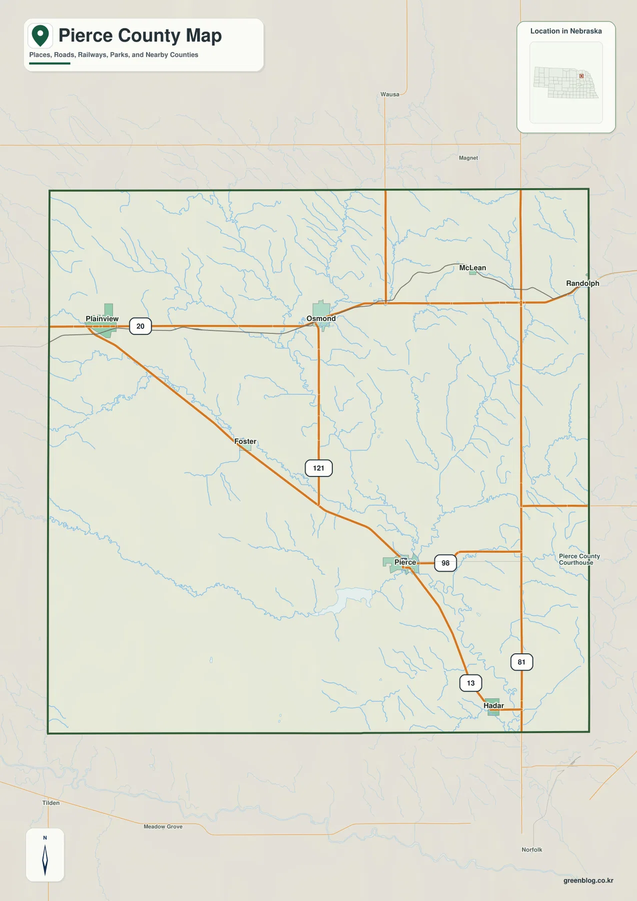
This map is most useful for broad orientation. It lets a reader locate Pierce, Plainview, Osmond, Hadar, and the major highways before moving to a more specialized image. If the main question is about streams, the water map provides more labels. If the question is about higher and lower ground, the elevation map gives a clearer answer. For driving, however, current navigation and road-condition information should always be checked because a static map cannot show temporary closures or construction.
Where Pierce, Plainview, Osmond, Hadar, McLean, and Foster sit
The city-focused map highlights six named communities: Pierce, Plainview, Osmond, Hadar, McLean, and Foster. Plainview and Osmond occupy the northern part of the county. McLean is farther east, Foster is west of the county’s center, and Pierce and Hadar are concentrated in the southeast. Seeing the communities on a simplified image makes their spacing much easier to understand than it is on a map filled with road and stream labels.
Plainview and Osmond share the Highway 20 corridor, but they are not adjacent towns. Plainview is closer to the western boundary, while Osmond is nearer the north-central part of the county. McLean is separated from Osmond to the east. Foster lies farther south and west, between the northern communities and the Pierce area in a broad geographic sense. Pierce and Hadar are close enough on the map to provide a useful southeastern pair for comparison with the northern towns.
Neighboring county names add another layer of context. Knox County is to the north, Wayne and Stanton counties are to the east and northeast, Madison and Cedar counties are to the west, and Antelope County is toward the southwest. The relationship between these boundaries and the six communities explains why Plainview feels connected to the western side of the county while McLean is visually much closer to the eastern edge.
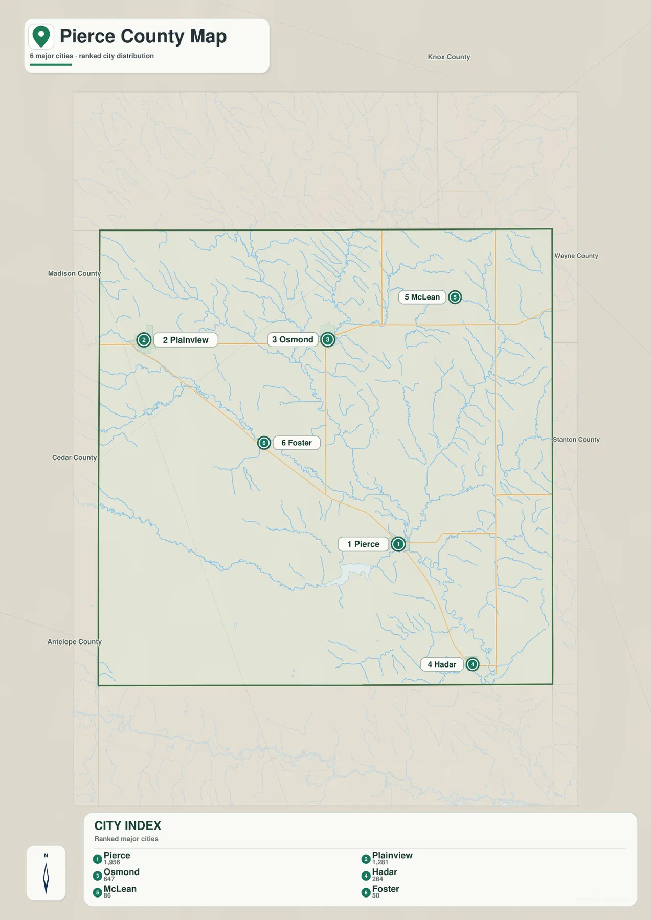
The city map works well for presentations, classroom activities, or a quick regional introduction because it reduces visual clutter. It is not intended to replace a street map or turn-by-turn navigation. When the goal is to understand how the towns connect by road, the general county map is the better companion because it shows Highway 20, 121, 98, 13, and the other routes together.
The North Fork Elkhorn River and named creeks
The North Fork Elkhorn River is the most prominent named river on the water map. It crosses the central part of Pierce County and continues toward the southeast. Several branches and creeks approach it from different directions. The W Branch N Fork Elkhorn River enters from the northwest, while the E Branch N Fork Elkhorn River and another East Branch are labeled in the northeastern part of the county. Together they make the main river corridor easier to recognize.
Other named waterways help distinguish different parts of the county. Breslau Creek and Dry Creek appear in the west and central areas. Willow Creek extends through the southern part of the county. Yankton Slough is visible to the east, and Middle Logan Creek lies farther toward the eastern side. Hadar Creek is labeled near Hadar, while Turtle Creek appears close to the southeastern boundary. The map therefore shows a network of separate streams rather than one isolated river running through otherwise featureless land.
The stream names become more meaningful when they are compared with the towns. Pierce is close to the North Fork Elkhorn River corridor. Smaller waterways descend from the Osmond area and from the western side of the county, while Hadar is associated with a different nearby creek. These relationships help explain why some lower areas form long, narrow bands on the elevation map. They should not, however, be treated as a current flood-risk assessment.
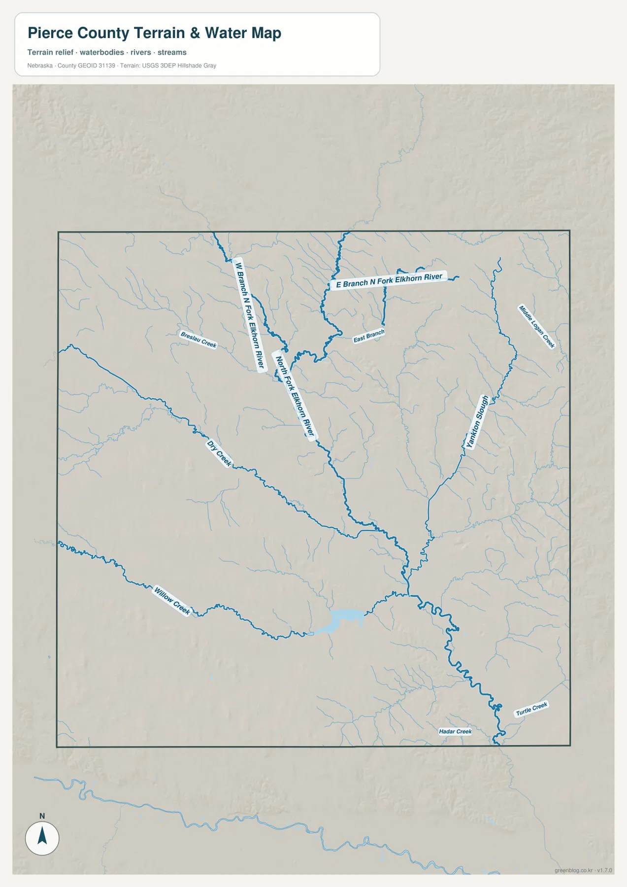
This image is useful for learning where streams run and how named waterways relate to the communities and roads shown on the other maps. It does not provide real-time water levels, water quality, fishing rules, public-access status, or flood insurance information. Those subjects change over time and require current information from USGS, local agencies, or other responsible authorities.
Lower river corridors and rolling higher ground
The elevation image makes the county’s broad relief easier to see. Lower ground follows the North Fork Elkhorn River and several of its tributaries, producing long bands that correspond closely with the waterways shown on the water map. Pierce sits near one of these lower corridors. Between the streams, the land rises into rolling uplands rather than forming a single flat surface across the county.
The northern area around Plainview and Osmond also contains visible variation. Small valleys cut through the surrounding farmland, and slightly higher ground separates one drainage from another. Similar patterns appear in the northeast, west, and southwest. The differences are not mountain-scale changes, but they are large enough to show why a road map alone gives only a partial picture of the county.
When the water and elevation maps are viewed together, many of the lower areas line up with the river and creek corridors. This makes it easier to understand the relationship between the North Fork Elkhorn River and the surrounding rolling landscape without relying on technical terrain analysis. The map is best used for county-level comparison, not for determining the exact height of a house site, road grade, survey benchmark, or parcel corner.
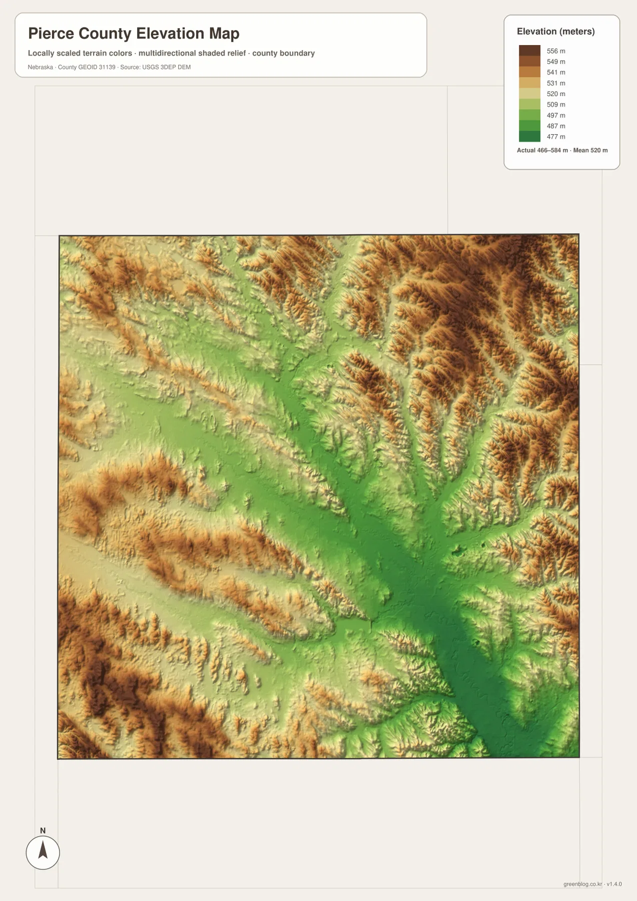
Anyone who needs precise elevation values should use appropriate source data such as the USGS 3D Elevation Program and, where necessary, professional surveying. The county map image is intended to show broad differences across Pierce County. It is not a substitute for engineering, construction, legal boundary, or site-specific measurement work.
Connecting the present-day map with county history
Pierce County’s official material identifies Pierce as the county seat and states that the county was organized in 1859. The county and city name are associated with Franklin Pierce. On the present-day map, Pierce appears as an important southeastern community where several roads meet, which makes its administrative role easy to understand geographically even without adding modern population statistics.
The county’s historical publication also discusses nineteenth-century settlement and transportation. Names such as Hadar, Pierce, Foster, and Plainview still appear on the modern map, allowing readers to connect historical references with present locations. Modern highways should not be assumed to follow the same paths as historical railroads or wagon routes. Anyone researching those older routes should consult dedicated historical maps and documents.
The North Fork Elkhorn River also appears in the county’s historical context. Local material describes early use of the river and records of past flooding near Pierce. Seeing the river close to the city on the water map helps place those historical accounts, but the historic record should not be used to define current flood zones. Current FEMA, state, or local flood information is required for property or insurance decisions.
Choosing the right Pierce County map for the task
Use the general county map when you need roads, communities, and the county boundary in one image. It is the most useful choice for initial orientation, especially if you begin with Plainview and Osmond along Highway 20 and then locate Pierce near Highways 98 and 13. The city map is cleaner when the main purpose is simply to show the relative locations of Pierce, Plainview, Osmond, Hadar, McLean, and Foster.
Choose the water map when the North Fork Elkhorn River, Dry Creek, Willow Creek, Hadar Creek, or other named waterways are the main subject. The elevation image is better for comparing the lower stream corridors with the rolling land between them. Using those two images side by side is especially effective in a classroom or presentation because the river locations can be compared directly with the lower terrain.
The ZIP below contains high-resolution JPG originals for the general county, city, water, and elevation maps. Each image is 2572 by 3638 pixels, giving labels more room than the smaller WebP previews used in the article. The files are suitable for printing, classroom material, presentations, regional comparison, and personal reference. They do not replace legal boundary maps, parcel records, professional surveys, flood determinations, or engineering plans.
Frequently Asked Questions
What is the easiest way to find Pierce County’s main communities?
Start with Plainview and Osmond along Highway 20 in the north, then locate Pierce in the southeast near Highways 98 and 13. Highway 121 runs south from the Osmond area. Once those reference points are clear, Hadar, McLean, and Foster are much easier to place.
Which map best shows the North Fork Elkhorn River and the creeks?
The water map is the best choice. It labels the North Fork Elkhorn River, its western and eastern branches, Dry Creek, Willow Creek, Yankton Slough, Hadar Creek, Turtle Creek, and other named waterways on one county-scale image.
Can the elevation map be used for a building site or property survey?
No. The elevation image is designed for broad county-level comparison. Exact site elevations, construction grades, parcel corners, survey benchmarks, and engineering work require appropriate official source data and professional measurement methods.
Map File Information
Download the high-resolution JPG versions of the Pierce County general, city, water, and elevation maps in one ZIP archive.
- Included Files: Use only the versions confirmed in the article and supplied images
- File Type: Use the confirmed download contents
- Intended Use: Printing, education, presentations, and map-based projects
Related Maps
Sources and references
County background and history are supported by Pierce County’s official website and history publication. Federal resources are included for boundary, hydrography, and elevation information.
- Pierce County, Nebraska – Official Website
- Pierce County – About Our County
- Pierce County history publication
- U.S. Census Bureau – TIGER/Line Shapefiles
- USGS – National Hydrography
- USGS – 3D Elevation Program
Green Map creates custom-edited map images using open geographic data sources such as geoBoundaries, Natural Earth, OpenStreetMap, and government open data. These maps are edited visual materials, not raw data files, and are provided for education, documents, presentations, and graphic reference.