Phelps County sits in south-central Nebraska, with Holdrege serving as the clearest reference point for understanding the county’s roads, communities, waterways, and relief. This Phelps County Nebraska Map page brings those elements together in separate views: a general county map, a city-connections map, a terrain-and-water map, and an elevation map. The WebP images are designed for quick viewing on the page, while the download box below provides the same map set as high-resolution JPG files in one ZIP archive.
A practical way to orient yourself is to begin at Holdrege. Highway 23 approaches from the west through Bertrand and Loomis, while Highway 34, Highway 6, and Highway 183 meet or pass near the city. Funk lies to the east and Atlanta to the south, so the county’s principal communities are spread in several directions rather than arranged along a single continuous urban corridor. The water and elevation views then add the Platte River, canals, creeks, and a clear west-to-east change in terrain.
Table of Contents
Roads and communities centered on Holdrege
The general county map makes Holdrege the most obvious anchor. It sits a little south of the county’s midline and is surrounded by the strongest road connections shown on the map. Highway 23 reaches the area from Bertrand and Loomis to the west, Highway 183 runs north and south, and Highways 34 and 6 approach from the southwest. For a reader who does not know Phelps County, using Holdrege first makes it much easier to place the other towns and to understand how the local road network is organized.
Bertrand lies close to the western boundary, with Loomis farther east on the same broad corridor toward Holdrege. Funk appears east of Holdrege, while Atlanta sits south of the main east-west group. This pattern matters because a quick glance at Highway 23 might make the county seem more linear than it really is. The wider map shows that Phelps County has a central hub with settlements distributed west, east, and south around it.
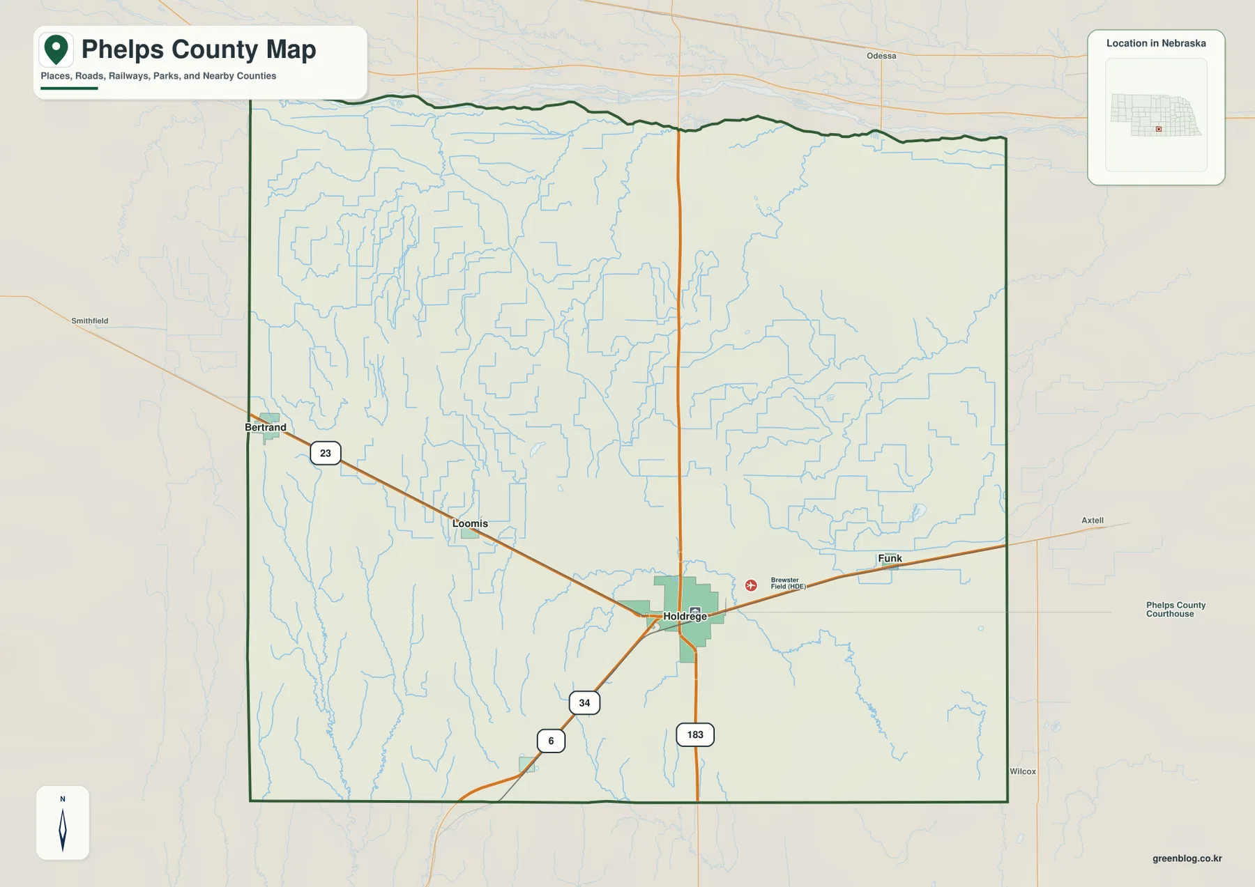
Brewster Field is labeled just east of Holdrege. Its presence is useful as a local landmark, but the map does not establish current operating conditions, access rules, or aviation services. Anyone planning to use the facility should consult current official information. The same caution applies to the smaller roads on the map: they are valuable for geographic context, but a printed county map should not replace current navigation, road-closure, or construction information.
Names outside the county boundary, including places near Smithfield, Odessa, Axtell, and Wilcox, provide useful context for the surrounding region. They help show how Phelps County connects to neighboring areas, but they should not be read as places inside the county. The dark county outline is the correct guide for separating the mapped county from nearby communities and roads beyond it.
Comparing Holdrege, Bertrand, Loomis, Funk, and Atlanta
The city-connections map removes much of the road detail and emphasizes five communities: Holdrege, Bertrand, Loomis, Funk, and Atlanta. Holdrege is shown as the hub, with the other four positioned around it. Bertrand and Loomis are to the west, Funk is to the east, and Atlanta is south of the hub. This simplified view is especially useful when the goal is to compare direction and spacing rather than to follow a particular highway.
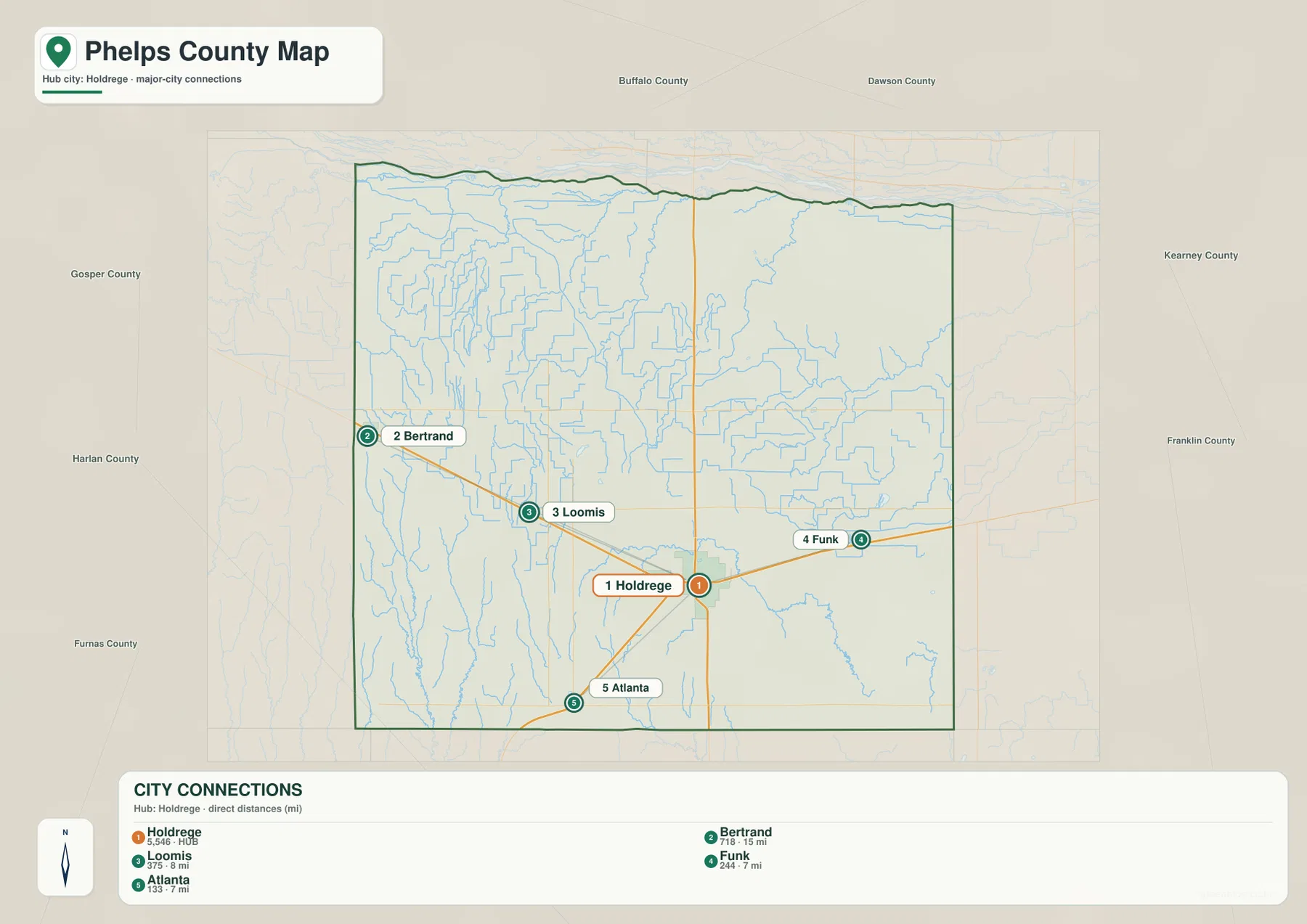
The connecting lines on this map represent direct, straight-line distances from Holdrege rather than driving routes. That distinction is important. A straight line may cross land that has no road, and an actual trip may require turns, different highways, or a longer path around local features. For travel planning, use the general map or an up-to-date navigation source. For geographic comparison, the direct-distance layout is a clean way to see how the communities relate to the county seat.
Holdrege is the county seat of Phelps County, a fact also reflected in the City of Holdrege’s official community information. Its administrative role matches what the maps suggest visually: multiple major roads converge near the city, while other communities are distributed around it. This makes Holdrege a natural reference point for school materials, county profiles, local history, and any explanation that needs to introduce Phelps County to readers who are unfamiliar with the area.
The numbers and labels included with the city map should be treated as map-reference information rather than a substitute for current population statistics. Population counts change over time, and direct distances are not the same as road mileage. The strongest use of this map is therefore relative location: identifying which communities lie west, east, or south of Holdrege and seeing how widely they are separated across a largely rural county.
The Platte River, canals, and named creeks
The terrain-and-water map is dominated by the Platte River along the northern edge of Phelps County. The river follows the county’s northern side, while the South Channel Platte River is labeled just to the south. Plum Creek appears near the northwest, and Whiskey Slough is marked near the northeast. These features make the northern part of the county more hydrologically complex than a single river line would suggest on a simpler road map.
A second major feature is the network of straighter water channels across the western and central portions of the county. Lateral E-65 and the Phelps County Canal are labeled on the map, and numerous other narrow blue lines cross agricultural land. Their regular geometry differs from the winding form of natural creeks. The map is useful for recognizing that irrigation and water distribution are part of the visible landscape, although it does not describe ownership, water rights, operating schedules, or current flow conditions.
Moses Hill Lagoon is labeled south of the county’s center. Farther east, North Dry Creek and Dry Creek form prominent drainage lines, while Sacramento Creek stands out in the southeast. Turkey Creek reaches the southern boundary, and Spring Creek and Elm Creek appear in the southwest. Taken together, these names show that Phelps County contains several different drainage areas rather than one uniform stream system.
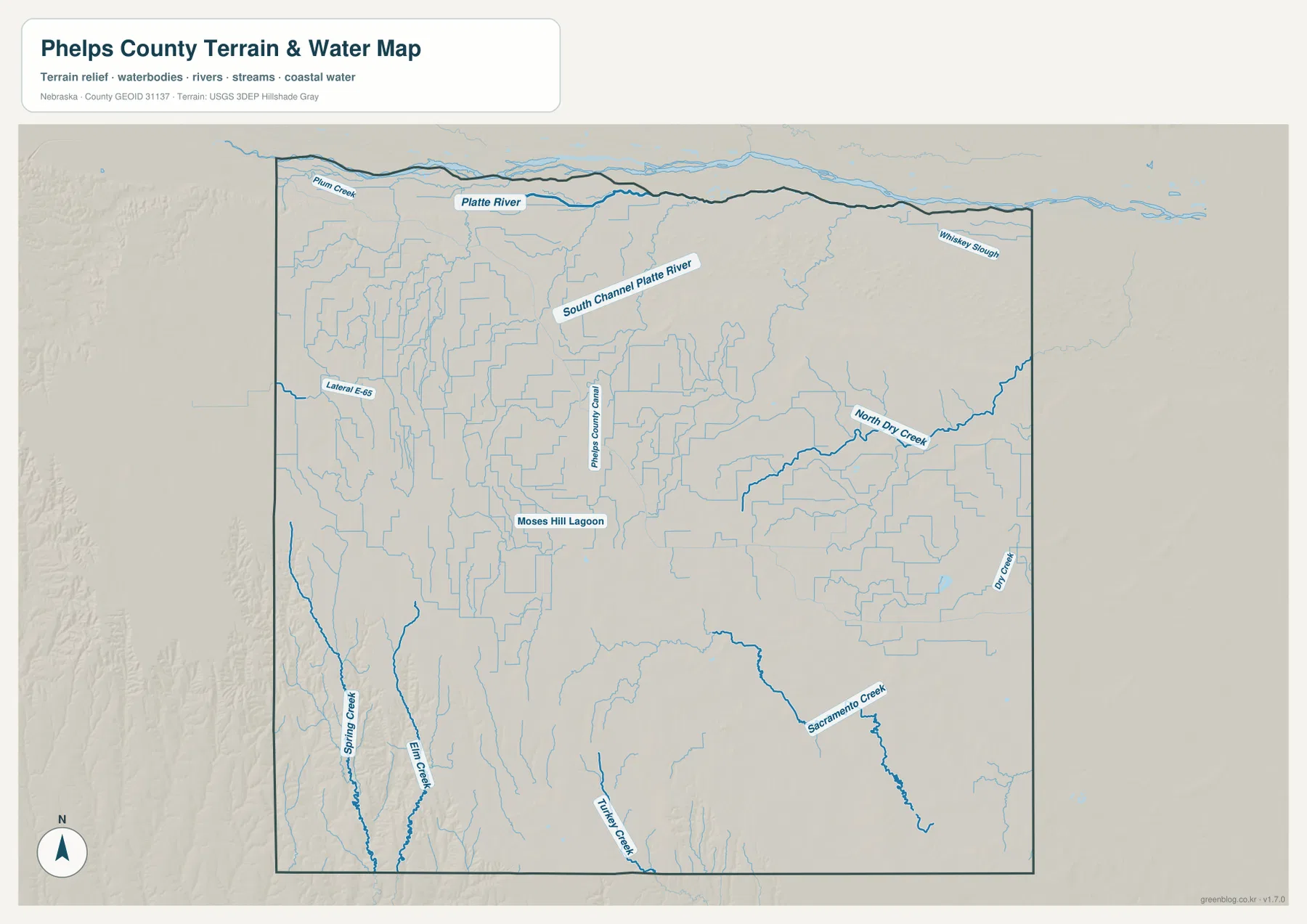
This water map is a county-scale reference, not a flood map, navigation chart, water-quality report, or parcel-access guide. The thickness of a blue line does not establish channel width or depth, and an intermittent or managed channel may behave differently from what a static map suggests. For hydrologic analysis, current conditions, or regulatory decisions, consult USGS National Hydrography and the appropriate local or state water-management source.
The visible canal network also fits the county’s development history. The City of Holdrege notes that efforts to use Platte River water for agriculture became increasingly important in the twentieth century and that irrigation water began reaching Phelps County in 1941. Seeing the canal and lateral lines beside the river and farm landscape gives useful geographic context to that history without turning the map into an irrigation-engineering document.
Higher western ground and lower eastern and northern terrain
The elevation map shows one of the clearest physical patterns in Phelps County. Its legend spans roughly 672 to 756 meters, while the map notes an actual surface range of about 663 to 771 meters and a mean near 709 meters. Brown and tan shades dominate much of the west and southwest, indicating higher ground. Green shades become more common toward the east and along the northern side, where lower terrain is associated with the Platte River corridor and other drainage features.
The western edge is elevated, but it is not a perfectly flat tableland. Shaded relief reveals narrow valleys and subtle ridges cutting through the higher surface. In the southwest, those features correspond with the Spring Creek and Elm Creek area shown on the water map. The combination is a useful reminder that broad agricultural plains can contain meaningful local relief even when the road network appears straight and regular.
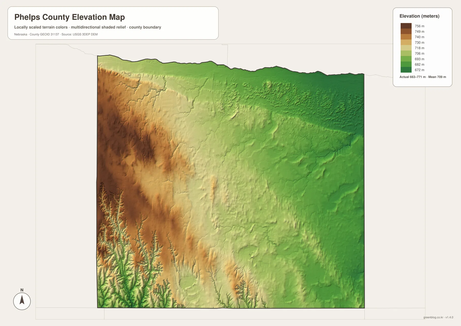
Around the middle of the county, colors shift toward yellow-green and light green. Holdrege sits within this transition rather than at either extreme. Eastward toward Funk, lower green terrain becomes more extensive, and the corridors around North Dry Creek and Dry Creek are easier to recognize. The north also trends lower as the land approaches the Platte River and its associated channels.
Viewing the water and elevation maps together makes the relationship between relief and drainage easier to understand. The Platte River lowlands, the Dry Creek system, and the Sacramento Creek area often correspond with lower-colored bands. Higher western ground is crossed by smaller drainage cuts rather than remaining uniformly level. The broad statement that the county descends from west toward east is useful, but the detailed surface still contains many local rises and valleys.
The elevation image is generalized for county-scale comparison. It should not be used to determine a parcel elevation, establish a construction grade, design drainage, set a survey benchmark, or define a legal boundary. Those tasks require suitable source data and professional methods. For classroom use, printing, regional comparison, and explaining why waterways occupy certain corridors, the map provides a clear and accessible picture of the county’s relative relief.
County history helps explain the modern map
A History Nebraska archival guide records that Phelps County was organized in 1873 and that the county seat moved from Williamsburg to Phelps Center and eventually to Holdrege. That history adds context to the modern map, where Holdrege is the most prominent community and the place where major roads converge. Its importance is not simply a cartographic choice; it reflects a long administrative and economic role within the county.
The same historical source notes that railroad development helped establish or expand communities including Atlanta, Bertrand, Loomis, and Holdrege during the late nineteenth century. Those names remain useful reference points on today’s map. The modern images on this page are not historical reconstructions, however, so they should not be used to locate vanished settlements, old property boundaries, or former rail alignments. Historical questions require dedicated archival maps and records.
The City of Holdrege describes the community’s rapid growth after the arrival of the railroad in the 1880s and its later development as an agricultural and service center. Irrigation strengthened that role further. When the road, water, and city maps are viewed together, it becomes easier to see why a community in this location could serve a broad rural area: roads approach from several directions, surrounding farmland is crossed by managed water channels, and neighboring towns are spaced across the county.
Phelps County is best understood as a combination of settlement pattern and physical geography. Holdrege anchors the road network, the Platte River defines the northern edge, canals and creeks cross the agricultural interior, and the land is generally higher in the west than in the east and north. None of those features alone tells the whole story. The four map views work best as complementary layers that answer different questions about the same county.
Choosing the right map for the task
Use the general county map when you need roads, boundaries, communities, and broad geographic context in one place. It is the best starting point for locating Holdrege, tracing Highway 23 west toward Loomis and Bertrand, or seeing how Highway 183 runs through the central part of the county. It also provides enough surrounding context to understand which labeled places lie outside the county boundary.
Choose the city-connections map when the main question is where the principal communities sit relative to Holdrege. It removes much of the visual clutter and makes west, east, and south relationships easier to compare. Because its lines are straight-line distance indicators rather than road routes, it should be paired with a road map when the goal is actual travel.
The terrain-and-water map is the most useful view for the Platte River, South Channel Platte River, Phelps County Canal, Dry Creek system, Sacramento Creek, Spring Creek, Elm Creek, and other named water features. The elevation map is better for the larger physical pattern of higher western ground and lower terrain toward the river and eastern drainages. Looking at those two maps side by side gives the most complete picture of how water and relief interact.
For printouts, presentations, or classroom materials, the downloadable JPG originals provide more room for labels than the on-page WebP previews. Each original image is 3638×2572 pixels. That higher resolution improves readability but does not change the maps into parcel, legal, survey, flood-control, or engineering products. Specialized decisions should always rely on the appropriate current authoritative source.
Frequently Asked Questions
Which map is best for comparing Holdrege with Bertrand, Loomis, Funk, and Atlanta?
The city-connections map is the simplest option because it emphasizes the five communities and their direction from Holdrege. Its connecting lines represent straight-line distance rather than driving routes, so use the general county map or current navigation information when actual road travel matters.
Where can I see the Platte River and Phelps County Canal most clearly?
Use the terrain-and-water map. It labels the Platte River and South Channel Platte River along the north, along with Phelps County Canal, Lateral E-65, North Dry Creek, Dry Creek, Sacramento Creek, Spring Creek, Elm Creek, and other local water features.
Can the elevation map be used for surveying or construction design?
No. The elevation image is a generalized county-scale view intended to compare relative relief. Parcel elevations, construction grades, drainage design, survey benchmarks, and legal boundaries require suitable official source data and professional surveying rather than the colors shown on this map.
Map File Information
Download the four high-resolution JPG maps shown on this page for Phelps County in one ZIP archive.
- Included Files: Use only the versions confirmed in the article and supplied images
- File Type: Use the confirmed download contents
- Intended Use: Printing, education, presentations, and map-based projects
Related Maps
Sources and references
County history and Holdrege context are supported by public information from History Nebraska and the City of Holdrege. Federal sources are included for boundary, hydrography, and elevation data used to understand the map themes.
- City of Holdrege – About Holdrege
- History Nebraska – Phelps County historical marker
- History Nebraska – Phelps County archives guide
- U.S. Census Bureau – TIGER/Line Shapefiles
- USGS – National Hydrography
- USGS – 3D Elevation Program
Green Map creates custom-edited map images using open geographic data sources such as geoBoundaries, Natural Earth, OpenStreetMap, and government open data. These maps are edited visual materials, not raw data files, and are provided for education, documents, presentations, and graphic reference.