You can download four high-resolution A3 JPG maps of Talbot County in one ZIP from this page. The set covers the county boundary and major roads, the relative positions of Talbotton and nearby municipalities, mapped creeks and lakes, and the county’s elevation range. Together they give a clearer picture of this west-central Georgia county than a single reference map can provide, especially because the terrain rises sharply toward the northwest while creek valleys cut through the interior.
Talbotton is the county seat and the main reference point on the supplied maps, but the county is not organized around one town alone. Woodland lies to the north, Junction City to the southeast, and Geneva to the south, with several state and U.S. routes linking those places across a landscape of short ridges and narrow drainage valleys. The maps are designed for county-level orientation rather than parcel research, engineering, navigation, or flood-risk decisions, so the most useful approach is to compare what each map emphasizes.
Table of Contents
Talbotton at the center of the road network
The county map makes Talbotton the easiest place to start. Talbotton sits slightly south of the county’s geographic center and is marked where several important roads meet. Route 22 and Route 80 pass through or near the town, while Route 36 reaches across the county farther north. To the northwest, Routes 116 and 85 connect toward Woodland and Manchester, and the southern part of the county is crossed by Routes 96 and 41 near Geneva. Junction City is tied into the eastern side by Route 90, with Route 208 continuing toward the winding eastern edge.
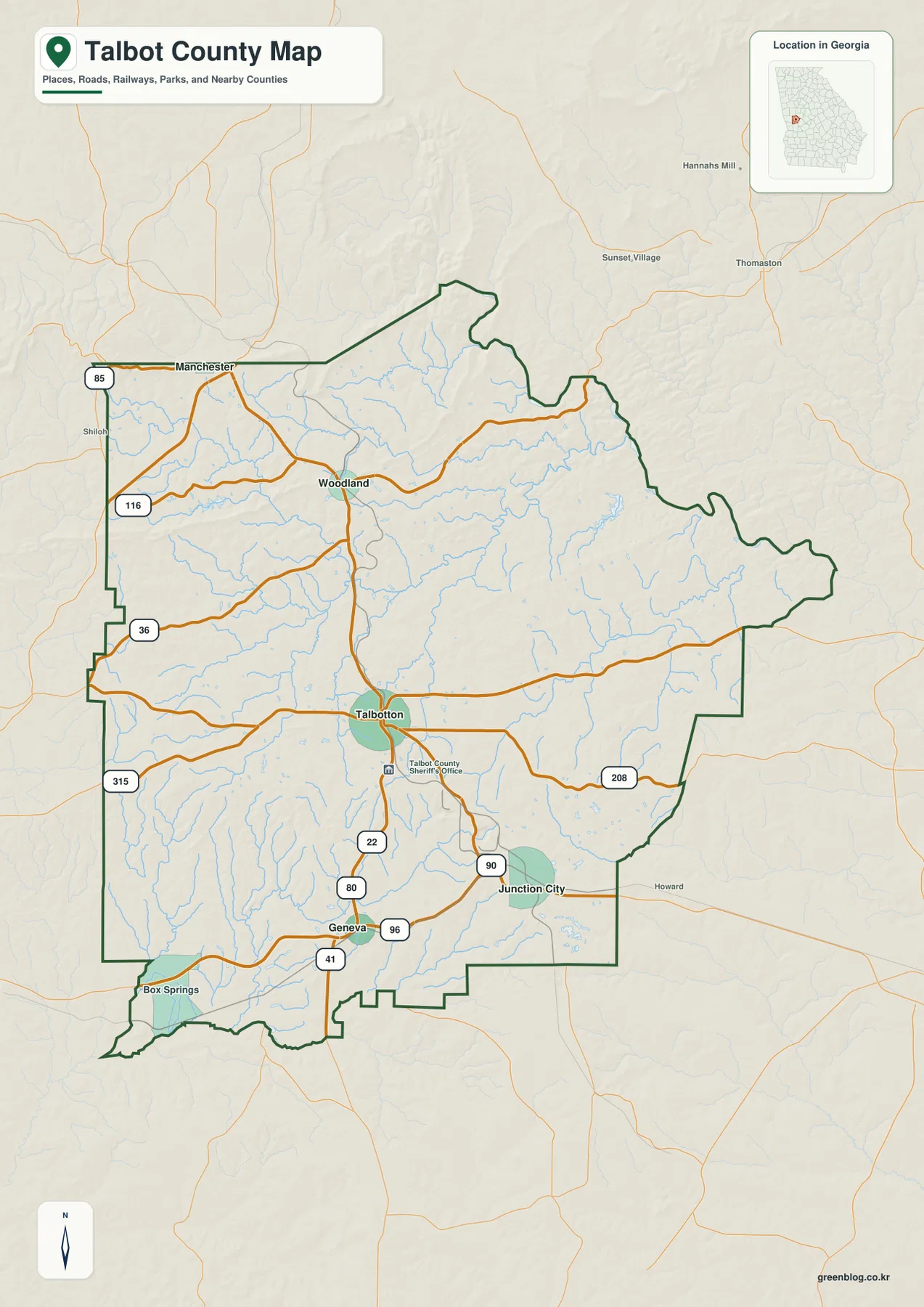
The boundary itself is useful context. Much of the outline is angular, but the eastern side has a long irregular section that contrasts with the straighter administrative segments elsewhere. The existing county material identifies the Flint River as an important part of Talbot County’s boundary setting. Box Springs also appears near the southwest side of the county map, while roads continue beyond the county line into neighboring areas. This makes the map useful for understanding where the main towns and routes sit before looking at more detailed city, water, or elevation information.
Three short links from Talbotton to the other mapped cities
The city-connections map narrows the view to four municipalities and uses Talbotton as the hub. Its city index lists Talbotton at 665, Junction City at 353, Woodland at 272, and Geneva at 101. Those figures are the values printed on the supplied city map; they are best treated as part of the map’s city reference rather than a substitute for the latest Census estimate. For current demographic research, the Census source in the reference section should be checked separately.
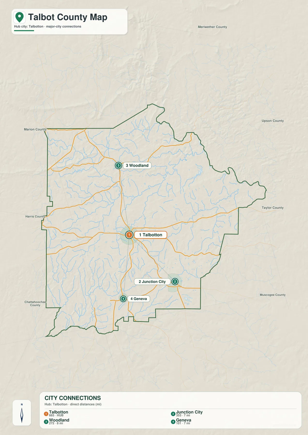
The spatial pattern matters more than the small numerical differences. Junction City is shown about 7 miles from Talbotton and lies to the southeast. Geneva is also about 7 miles away but sits to the south, while Woodland is about 8 miles north of the county seat. These are direct straight-line distances, not driving distances along the road network. A route that bends around streams or follows a different highway alignment may be longer. The city map therefore works best as a quick comparison of direction and separation, while the county map provides the road context needed to understand actual travel.
The four municipalities also occupy different parts of the county rather than forming one continuous urban strip. Talbotton is the administrative center, Woodland represents the northern part of the county, and Junction City and Geneva provide southeastern and southern reference points. Seeing those locations first makes the water and elevation maps easier to interpret because the reader already has a set of familiar place markers.
Creek valleys spread across the county interior
The terrain-and-water map shows a dense network of smaller streams rather than one dominant interior channel. Marshall Creek and Ransome Lake are labeled in the northwestern part of the county. Edwards Creek crosses the central-western area, while Richland Creek and Potter Creek stand out farther east. In the southern half, South Fork Upatoie Creek and Baker Creek are among the named waterways, and Fielder Lake appears as a distinct water body near the southeast side. Numerous smaller tributaries fill the spaces between those labels.
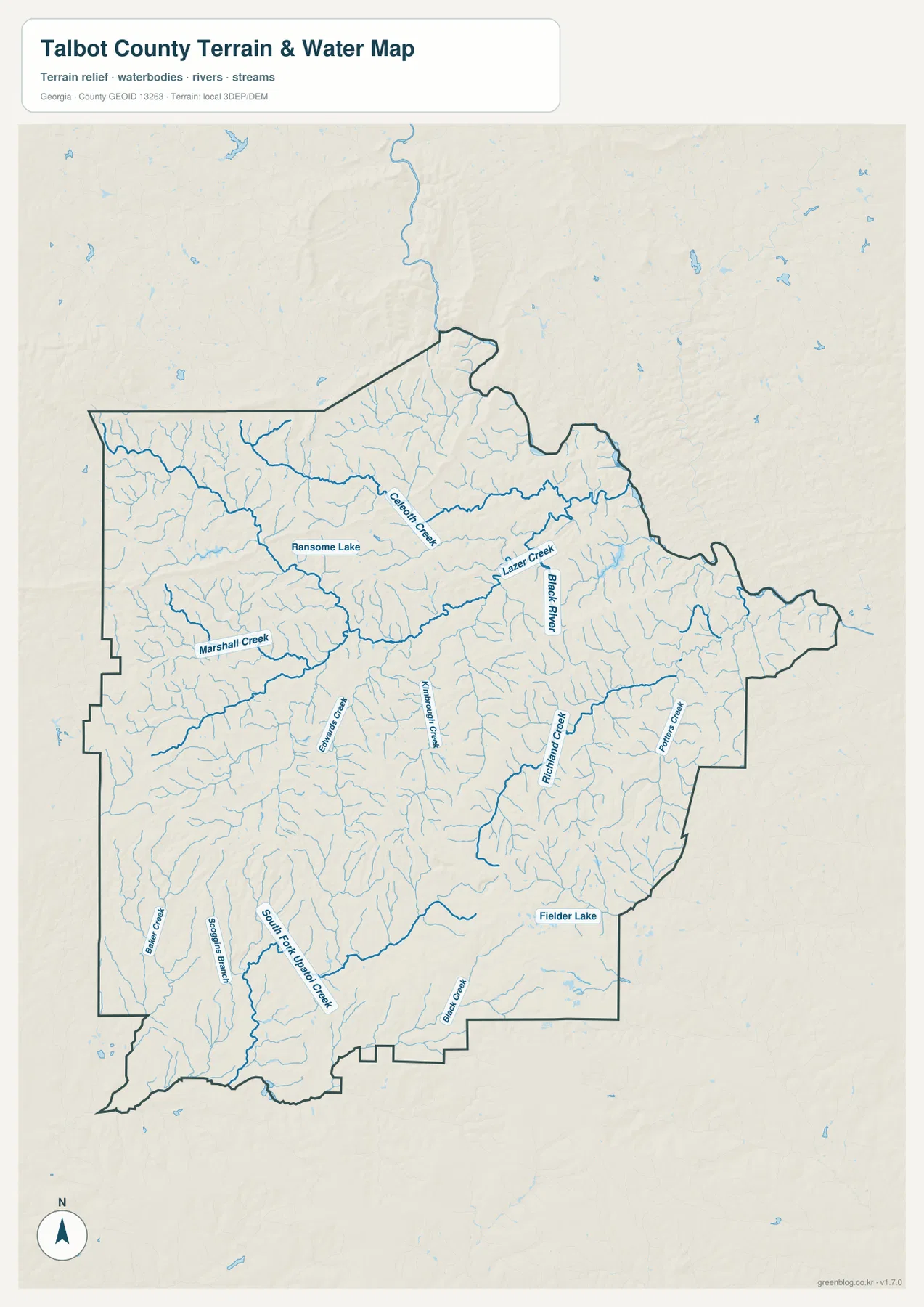
This pattern helps explain why the county’s surface appears finely divided on the relief background. Waterways occupy narrow low areas, while short ridges remain between adjacent drainage lines. Around Woodland and the northwestern section, several tributaries cut across higher terrain. South of Talbotton and toward Junction City, small channels remain frequent even where the larger labeled streams are farther apart. The supplied material also identifies the Flint River as part of the county’s broader eastern boundary context, but this water map should not be read as a flood-hazard map, a property map, or a navigation chart.
Ransome Lake and Fielder Lake are useful visual anchors because they are easier to spot than many of the narrow creeks. They also show that the water layer includes both flowing channels and standing water. The map does not indicate public access, ownership, boat suitability, or flood probability for those features. Its purpose is to show where water is located relative to the county boundary and surrounding terrain.
The northwest rises far above the lower valleys
The elevation map gives Talbot County an actual displayed range of about 100 to 386 meters, with a mean near 191 meters. That is a substantial difference within one county. The highest-looking terrain is concentrated along the northwest and parts of the northern edge, where brown and tan shading marks a broad belt of elevated ridges. Lower green areas become more common through the east and southeast, while the far southwest also contains deeply cut lower ground.
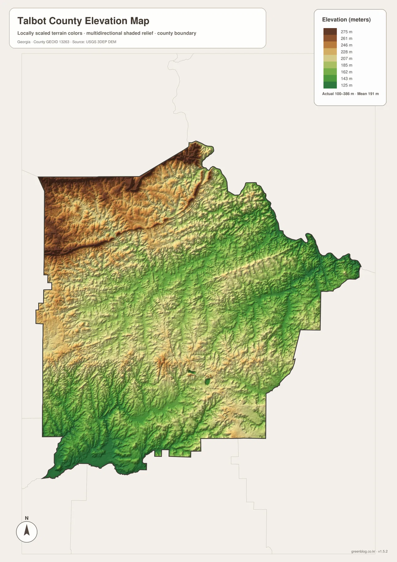
The relief becomes especially meaningful when compared with the water map. Many creeks follow the greener, lower corridors between ridges, and the close spacing of those valleys creates a textured surface rather than a broad flat plain. The northwest stands out because its ridges remain higher across a larger area before dropping toward the central and eastern drainage network. This generalized elevation surface is well suited to county-scale comparison, but it is not survey-grade data for a specific parcel, building site, road design, or engineering calculation.
What each file adds to the Talbot County picture
A reader looking only for Talbotton, Woodland, Junction City, Geneva, and the main numbered routes will usually get the quickest answer from the county map. The city-connections version is better when the question is how the three smaller municipalities sit around Talbotton and how far apart they appear in a straight line. When the focus shifts to Richland Creek, Marshall Creek, Edwards Creek, South Fork Upatoie Creek, or the small lakes, the water map removes much of the road emphasis and makes drainage easier to follow.
The elevation map answers a different question: how much the ground rises and falls across the county. Its 100–386 meter range makes the northwest-versus-valley contrast visible immediately. Comparing that surface with the road map also shows that roads cross a landscape of ridges and creek bottoms rather than a uniformly level area. Keeping all four JPG files together is useful because a place that looks ordinary on the county map may make more sense once the nearby creek valley or elevation change is visible.
The four-map set is most useful as a layered reference, not as four versions of the same information. For a classroom or local-history project, the county map can establish location first, the city map can clarify settlement relationships, and the water and elevation maps can explain the physical setting. For trip planning, the maps can help with general orientation before a current navigation service is used. For property, flood, construction, or legal questions, specialized official records are still necessary.
Reading Talbot County without overinterpreting the maps
Several limitations are worth keeping in mind. The county reference map does not include every local road, unincorporated community, parcel line, or service location. The city distances are straight-line measurements and should not be quoted as road mileage. The water layer identifies mapped streams and lakes but does not classify flood zones or public access. Elevation colors summarize county-scale terrain and should not replace a site survey.
Within those limits, the maps provide a strong geographic overview. Talbotton is clearly the road and administrative reference point, while Woodland, Junction City, and Geneva occupy different directions around it. Creek valleys are widespread, and the elevation map shows that the northwestern high ground differs sharply from lower corridors elsewhere. That combination is what makes the set more useful than a simple county outline: the reader can connect settlements and roads to the physical landscape that surrounds them.
Frequently Asked Questions
Are the 7- and 8-mile city distances driving distances?
No. The city-connections map measures straight-line distance from Talbotton. Junction City and Geneva are each shown at about 7 miles, while Woodland is about 8 miles away. Actual road mileage can be longer.
Can the creek map be used to determine flood risk near the Flint River or local streams?
No. The supplied water map is a county-scale reference for streams, tributaries, and lakes. It does not show regulatory flood zones, flood depth, property boundaries, or safe navigation routes.
Does the 100–386 meter elevation range provide survey-grade heights?
No. The range summarizes the generalized elevation surface shown on the county map. A professional survey or other site-specific source is required for precise elevations at a parcel or structure.
Sources and reference data
- U.S. Census Bureau QuickFacts for Talbot County
- New Georgia Encyclopedia: Talbot County
- USGS National Hydrography
- USGS 3D Elevation Program
Map File Information
The ZIP contains four original high-resolution A3 JPG files: the county map, city-connections map, water map, and elevation map shown on this page.
- Included Files: The map files described and shown on this page
- File Type: JPG map files packaged in a ZIP archive
- Intended Use: Printing, education, presentations, and map-based projects
Related Maps
Green Map creates custom-edited map images using open geographic data sources such as geoBoundaries, Natural Earth, OpenStreetMap, and government open data. These maps are edited visual materials, not raw data files, and are provided for education, documents, presentations, and graphic reference.