Richmond County sits on Georgia’s eastern side, where Augusta and the Savannah River provide the clearest geographic reference points. This page brings together four views of the same county: a boundary and road map, a city-connections map, a waterways and terrain map, and an elevation map. Visitors who need the files rather than only the on-page previews can download one ZIP containing four high-resolution A3 JPG maps. The previews remain in WEBP format so the page is lighter to load, while the larger JPG files are intended for printing, classroom use, reports, and closer inspection.
Taken together, the maps show a county that is strongly oriented toward Augusta in the northeast and the river side of the county, while Hephzibah and Blythe sit farther south and southwest. The eastern edge is lower and closely tied to the Savannah River, whereas the western and southwestern interior becomes noticeably hillier. Creeks such as Butler Creek, Rocky Creek, Spirit Creek, and Little Spirit Creek add another layer to that pattern, making it possible to compare settlements, water, and relief instead of treating each map as a separate illustration.
Table of Contents
Augusta anchors a county that opens toward the southwest
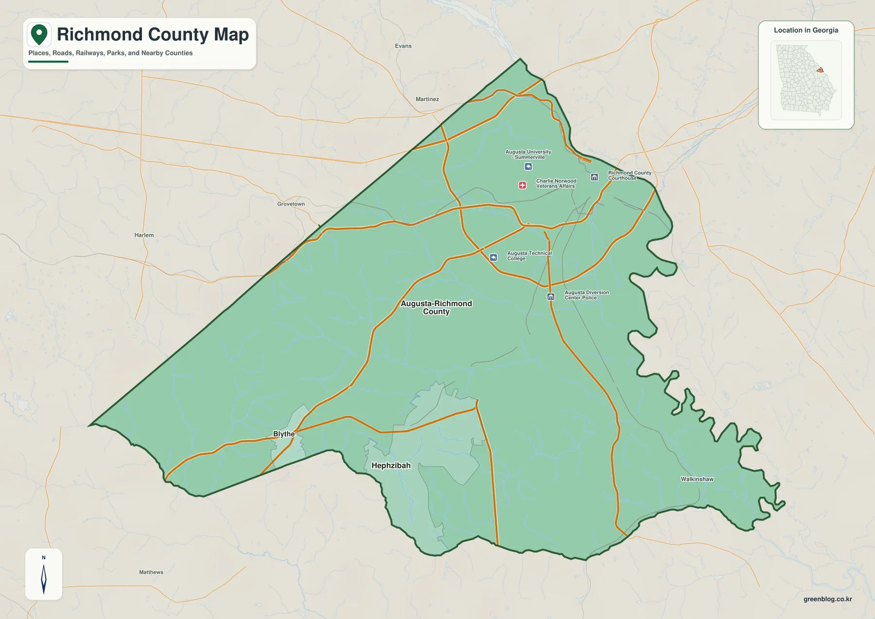
The county map makes Richmond County’s shape easy to recognize. Augusta occupies the northeastern part of the county near the Savannah River side, while the boundary widens and stretches southwest into a much larger area with fewer labeled urban points. The outline is not a simple rectangle: the east side contains a long series of river-related bends, the north narrows toward Augusta, and the southwest extends away from the urban core. That shape matters when reading the rest of the page because a point that looks “central” within Augusta is not central within the county as a whole.
Several labels around Augusta reinforce how concentrated the county’s urban functions are in the northeast. The supplied map includes Augusta University Summerville, Charlie Norwood VA Medical Center, Richmond County Courthouse, Augusta Technical College, and other selected facilities. Those labels are not meant to represent every school, government building, hospital, or service site. Instead, they give the reader landmarks for the built-up Augusta area while the broad southern and western portions of the county remain visually quieter. Outside the county line, names such as Evans, Martinez, Grovetown, and Harlem provide additional orientation without turning the map into a regional street atlas.
| State | Georgia |
|---|---|
| County | Richmond County |
| County seat | Augusta |
| Places emphasized on the supplied maps | Augusta-Richmond County, Hephzibah, Blythe |
| County establishment shown in the source article | 1777 |
| Download package | Four high-resolution A3 JPG maps in one ZIP |
Hephzibah and Blythe sit apart from the Augusta hub
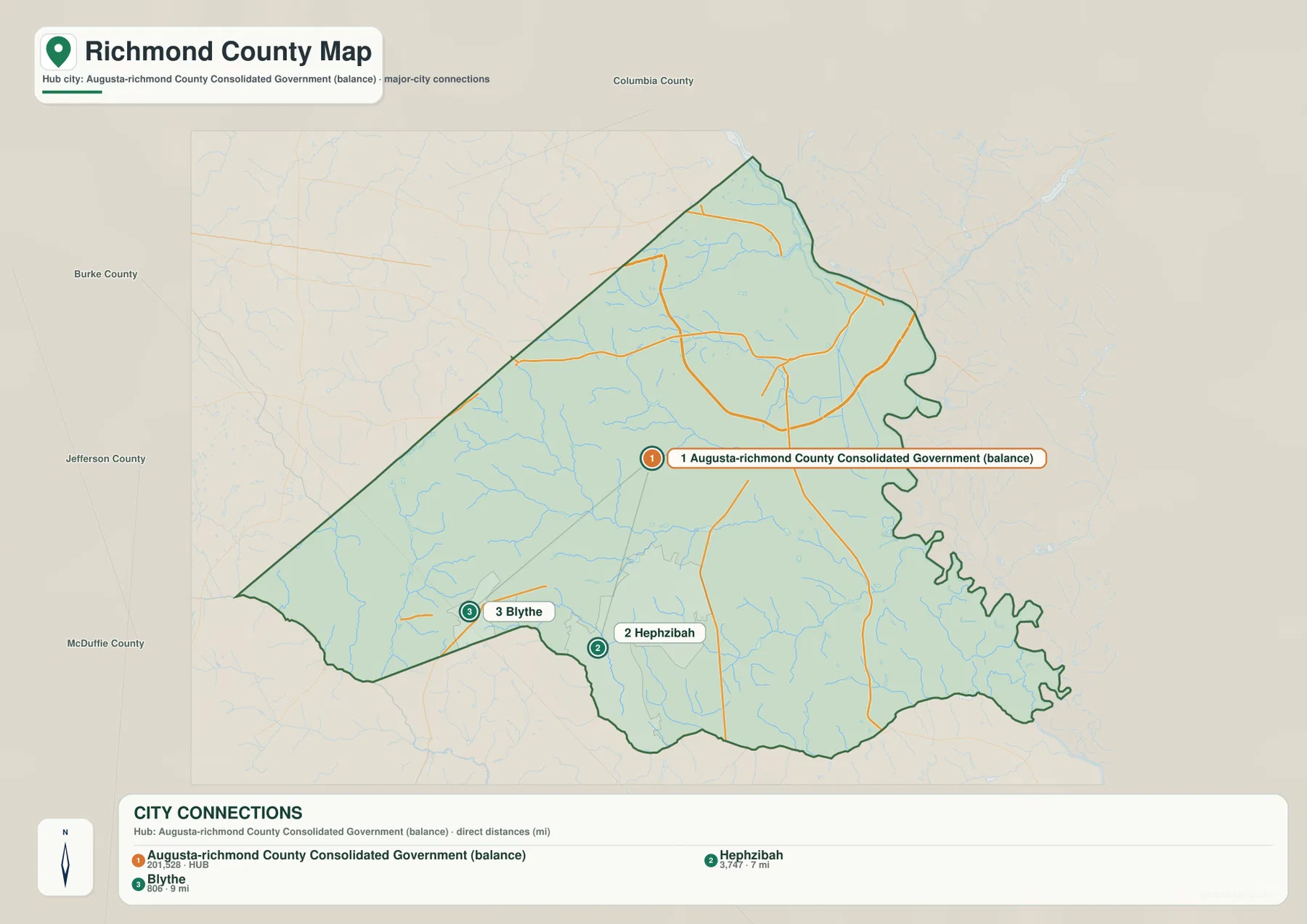
The city-connections map strips away much of the background detail so the relationship among the three labeled places is easier to see. Its hub is named “Augusta-Richmond County Consolidated Government (balance),” which is the label used by the supplied map data. The current Richmond County article also identifies Augusta as the county seat and a consolidated city, while Hephzibah and Blythe remain separate incorporated places. On the map, Hephzibah lies south of the Augusta hub, and Blythe lies farther to the southwest near the county’s western side.
The connection panel gives straight-line distances from the Augusta-Richmond County hub: about 7 miles to Hephzibah and about 9 miles to Blythe. These are not driving distances. They do not follow local streets, highway interchanges, turns, or a specific starting address, so they should not be used to estimate travel time. Their value is geographic comparison. A reader can immediately see that Hephzibah is the closer southern city, while Blythe is slightly farther away and shifted west. Comparing this map with the county map also helps explain why the southwest portion of the county feels more separate from the dense Augusta area.
Why the connection distances should not be used as route mileage
A straight line answers a different question from a road route. It shows how far apart two mapped points are in geographic terms, but real driving follows a network that bends around neighborhoods, waterways, interchanges, and local access points. For that reason, the city map works well when comparing settlement spacing or preparing a simple location graphic, but a current road-routing service is the better source for turn-by-turn travel distance. Keeping that distinction clear prevents the connection panel from being read as a navigation product.
The Savannah side is fed by a dense network of creeks and ponds
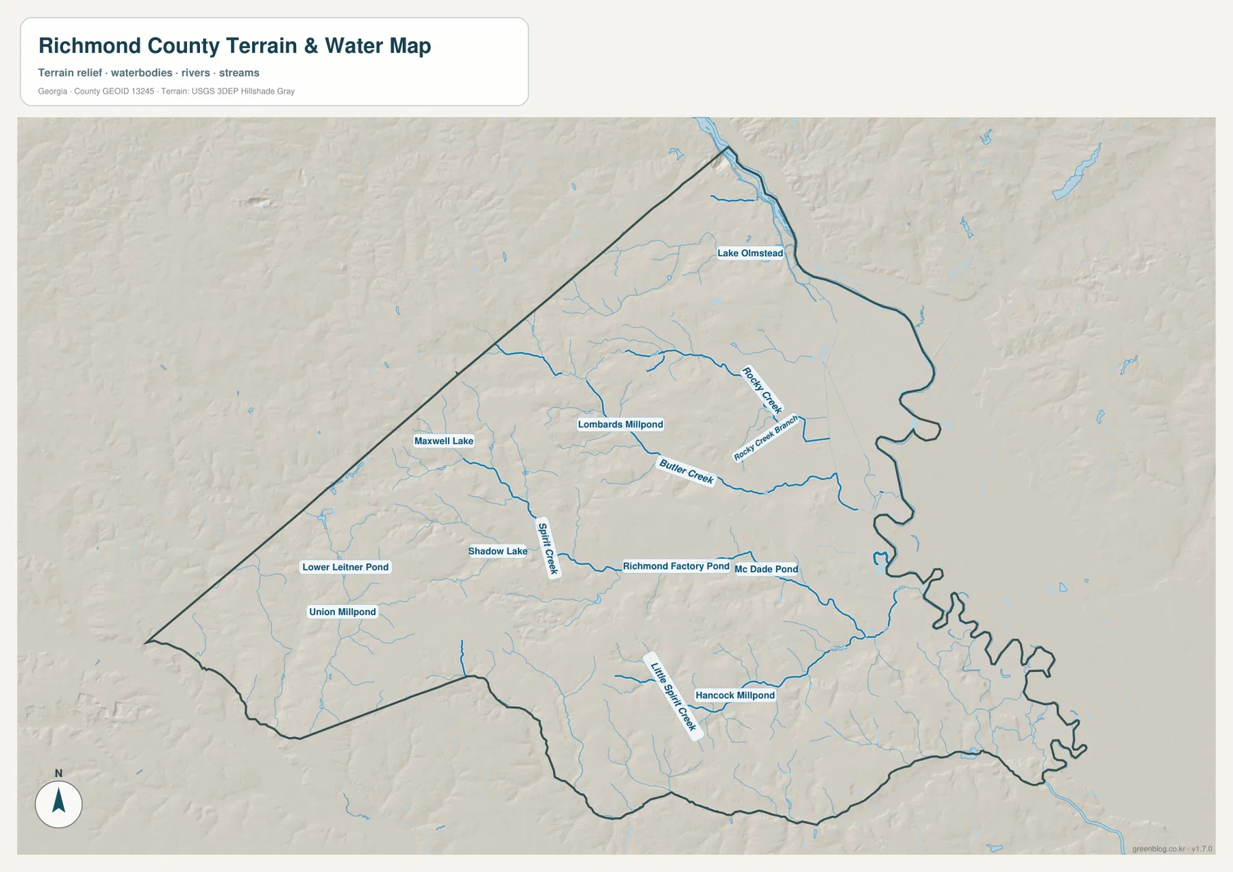
Water becomes much more prominent on the terrain-and-water map. Richmond County’s eastern side follows the Savannah River area, while numerous smaller streams cross the interior. Butler Creek is one of the longest named creeks visible through the central part of the county. Spirit Creek and Little Spirit Creek appear farther south, while Rocky Creek and Rocky Creek Branch are closer to the eastern urban side. These waterways are supplemented by a collection of smaller lakes and millponds, so the county’s hydrology is not defined by one large river alone.
The map labels Lake Olmstead near the northern end, Lombards Millpond and Maxwell Lake farther west, Shadow Lake and Lower Leitner Pond in the interior, Union Millpond in the southwest, and Richmond Factory Pond, Mc Dade Pond, and Hancock Millpond in other parts of the county. Seeing these names on a relief background makes the creek network easier to follow than on the general county map. Many small channels descend through shallow valleys toward the lower eastern side, giving the map a branching appearance across otherwise lightly labeled rural areas.
This map should be read as a water-location reference, not as a flood-risk map, legal water boundary, parcel layer, depth chart, or navigation chart. A creek shown on the page can help a reader understand the county’s physical setting, but it does not establish how wide the stream is at a particular date or whether nearby land is inside a regulatory flood zone. Those questions require the appropriate official or engineering source.
Elevation falls toward the eastern river side
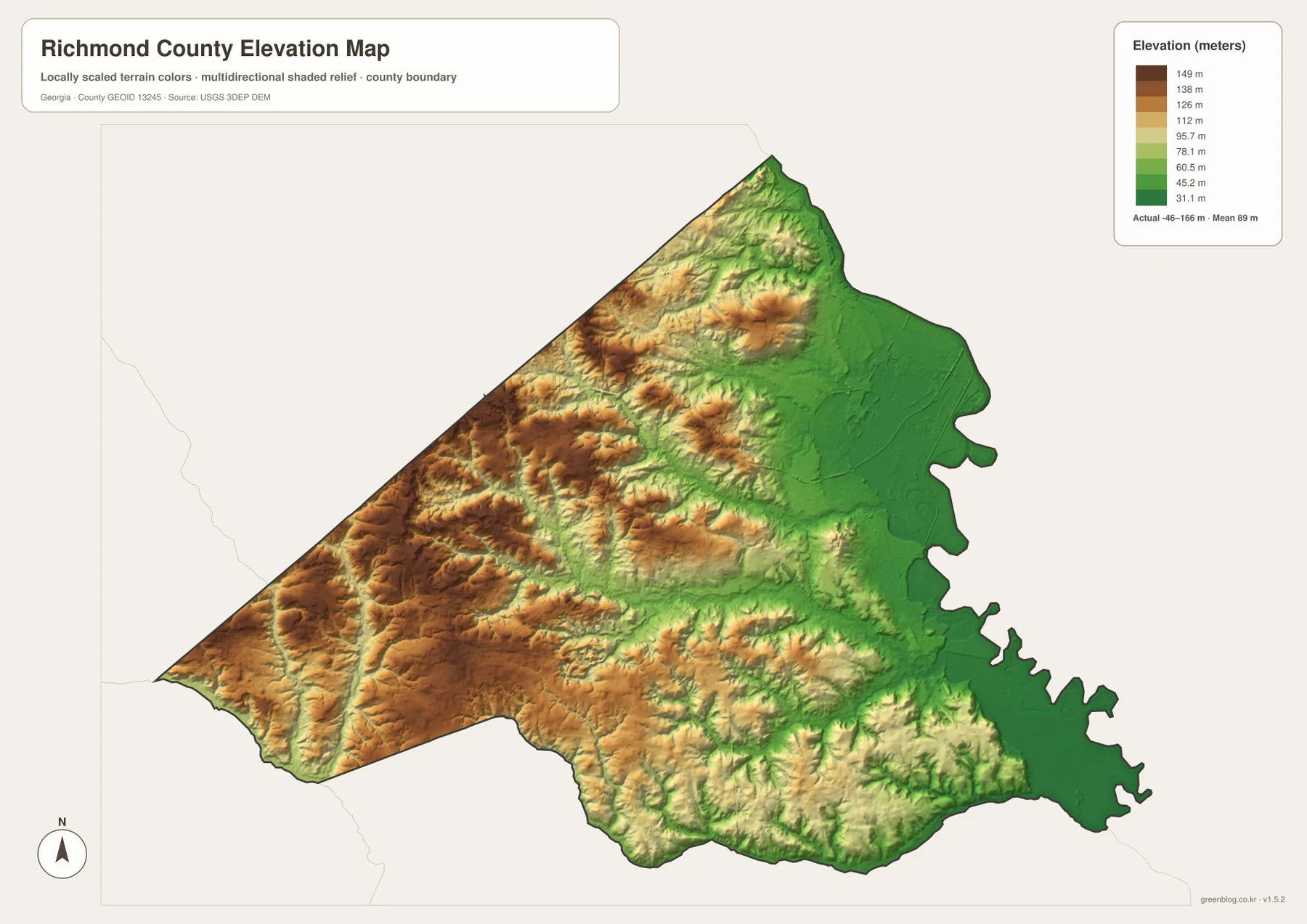
The elevation map adds a physical explanation to patterns that are only hinted at on the other views. Greens dominate the eastern and southeastern side of Richmond County, indicating lower terrain near the river. Browns and tan colors become more common through the west and southwest, where ridges and rolling ground are more pronounced. The northwestern interior also shows repeated rises and valleys. This creates a clear east-to-west contrast: the Augusta and Savannah River side is generally lower, while the county becomes hillier as it extends away from the river.
The legend on the supplied image reports an actual elevation range of roughly -46 to 166 meters and a mean of about 89 meters for the mapped surface. Those values should be treated as values from this generalized county-scale elevation product, not as survey elevations for an individual property. The map is most useful for relative comparison—identifying broad lowlands, higher ridges, and the direction of terrain change. It is not appropriate for construction staking, drainage design, property grading, or any task that depends on engineering-grade vertical accuracy.
Comparing all four views reveals more than any single map
The four maps become most useful when read together. The county map establishes the boundary and shows how the Augusta urban area is concentrated near the northeast. The city map then reduces that information to three key settlement points and makes the separation of Hephzibah and Blythe easier to measure. The water map explains why the eastern side is visually different by showing the Savannah-side setting and the many creeks that cut across the county. Finally, the elevation map shows that those waterways occupy a landscape that generally drops toward the east and rises through the western interior.
That combination gives Richmond County a distinctive geographic story. Augusta is not simply the largest labeled place on the map; it is positioned close to the river side, where the terrain is lower and where the county’s institutional labels are concentrated. Hephzibah and Blythe sit farther from that northeastern concentration, and much of the southwest is represented more by roads, streams, and relief than by dense place labeling. For a classroom explanation or a report graphic, this lets the reader move from “where is the county?” to “where are the main places?” and then to “what physical features surround them?” without switching to unrelated map sources.
The source article notes that Richmond County was established in 1777 and identifies the Savannah River, Fort Eisenhower, medical and higher-education activity, manufacturing, and highway access as part of the county’s broader setting. Not all of those topics are mapped in detail here, and the page does not attempt to replace a current transportation, installation, property, or municipal-service map. The strength of this four-map set is narrower and more practical: it provides a consistent county outline while changing the emphasis from settlements and roads to water and elevation.
- Use the county map when the boundary, Augusta, Hephzibah, Blythe, and selected road or landmark context are most important.
- Use the city-connections map when you need a simplified comparison of the three labeled places; remember that the 7- and 9-mile figures are straight-line distances.
- Use the water map when the Savannah-side setting, Butler Creek, Spirit Creek, Rocky Creek, or the labeled ponds and lakes are relevant.
- Use the elevation map when the key question is the lower eastern side versus the hillier west and southwest.
Frequently Asked Questions
Why does the city map use “Augusta-Richmond County Consolidated Government (balance)” as the hub?
That is the name printed by the supplied city-connections map for its central point. The source article also describes Augusta as the county seat and a consolidated city, while Hephzibah and Blythe remain separate incorporated places. This article keeps the map’s data label intact when discussing the hub, but uses Augusta-Richmond County in ordinary prose so the relationship is easier to follow.
Does the Savannah River define the important eastern side of Richmond County on these maps?
Yes in the geographic sense shown by the supplied materials. The source article identifies the Savannah River as a major county feature, and both the boundary and water maps place the river side along the county’s eastern edge. For a legally exact jurisdiction line, however, use an official boundary dataset rather than measuring the line from this page image.
Can the elevation map be used for surveying or engineering work?
No. It is a generalized county-scale reference intended to show broad differences in relief. The legend summarizes the mapped surface, but it does not replace a field survey or site-specific elevation data. Use it to understand the lower eastern side and higher western terrain, not to set construction grades, property elevations, or drainage specifications.
Sources and reference data
The following links are the supplied authoritative references for county background and for the boundary, water, and elevation data types represented on the page. The maps here are designed for geographic orientation and downloadable reference use; consult the original source when a current statistic, legal boundary, or technical dataset is required.
- Augusta’s official history page
- U.S. Census Bureau QuickFacts for Richmond County
- New Georgia Encyclopedia: Richmond County
- U.S. Census Bureau TIGER/Line Shapefiles
- USGS National Hydrography
- USGS 3D Elevation Program
Map File Information
The page uses lightweight WEBP previews, while the download ZIP contains four original high-resolution A3 JPG maps of Richmond County.
- File Type: one ZIP containing four high-resolution A3 JPG files
Related Maps
Green Map creates custom-edited map images using open geographic data sources such as geoBoundaries, Natural Earth, OpenStreetMap, and government open data. These maps are edited visual materials, not raw data files, and are provided for education, documents, presentations, and graphic reference.