Randolph County sits in southwest Georgia, where Cuthbert and Shellman provide the clearest anchors for understanding the county. Cuthbert is the county seat and the main road junction shown on the map, while Shellman lies farther east near the county edge. This page combines a boundary-and-road map, a ranked city map, a terrain-and-water map, and an elevation map. The four original high-resolution A3 JPG maps are also available together in one ZIP file for download.
The county is easier to understand when roads, streams, and relief are viewed together. Several numbered roads meet around Cuthbert, but the spaces between the towns are filled with branching creeks rather than a single dominant river corridor. The elevation surface adds another layer: the north and west contain more of the higher rolling ground, while many eastern and southeastern drainage valleys sit lower. That combination gives Randolph County a more varied local landscape than a simple road map alone suggests.
Table of Contents
Cuthbert as the Road and Administrative Anchor
On the county map, Cuthbert appears slightly west of center and is marked with the Randolph County Courthouse. Shellman is farther east, close to the irregular eastern side of the county. Route labels 82 and 50 form the most obvious east–west connection across the middle, while 27 and 1 run south from the Cuthbert area. Other visible route numbers include 266 toward the southwest, 216 farther south, and 41 near the Shellman side of the county.
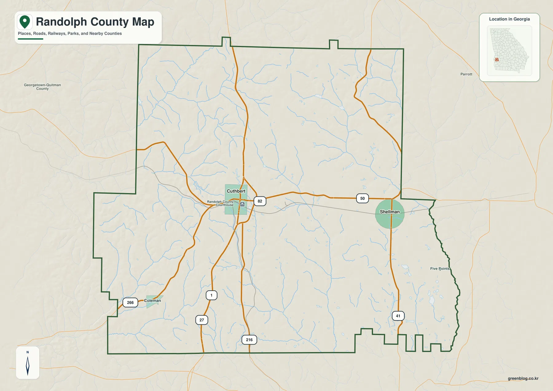
The boundary itself is useful context. Labels around Randolph County include Quitman, Clay, Calhoun, Stewart, Webster, and Terrell counties. The outline is not a simple rectangle: the western and southern edges step inward and outward, while the eastern side becomes especially irregular toward the southeast. That shape matters when comparing nearby places or matching a local road with the correct county.
For basic orientation, Cuthbert is the best starting point because several routes converge there and the courthouse marker identifies the administrative center. From that point, Shellman is reached by following the eastward corridor, while other roads lead toward the southern and southwestern portions of the county. The map is intended for geographic reference rather than turn-by-turn navigation, so it should not be read as a source for live traffic, lane counts, or current construction conditions.
A Two-City Pattern: Cuthbert and Shellman
The ranked city map deliberately simplifies the settlement picture. Its City Index lists Cuthbert at 2,991 and Shellman at 974, placing the two cities in a clear first-and-second order. Cuthbert is positioned in the west-central part of the county, while Shellman is farther east. The separation between them makes the map useful for seeing that Randolph County is not organized around a single cluster of named urban places.
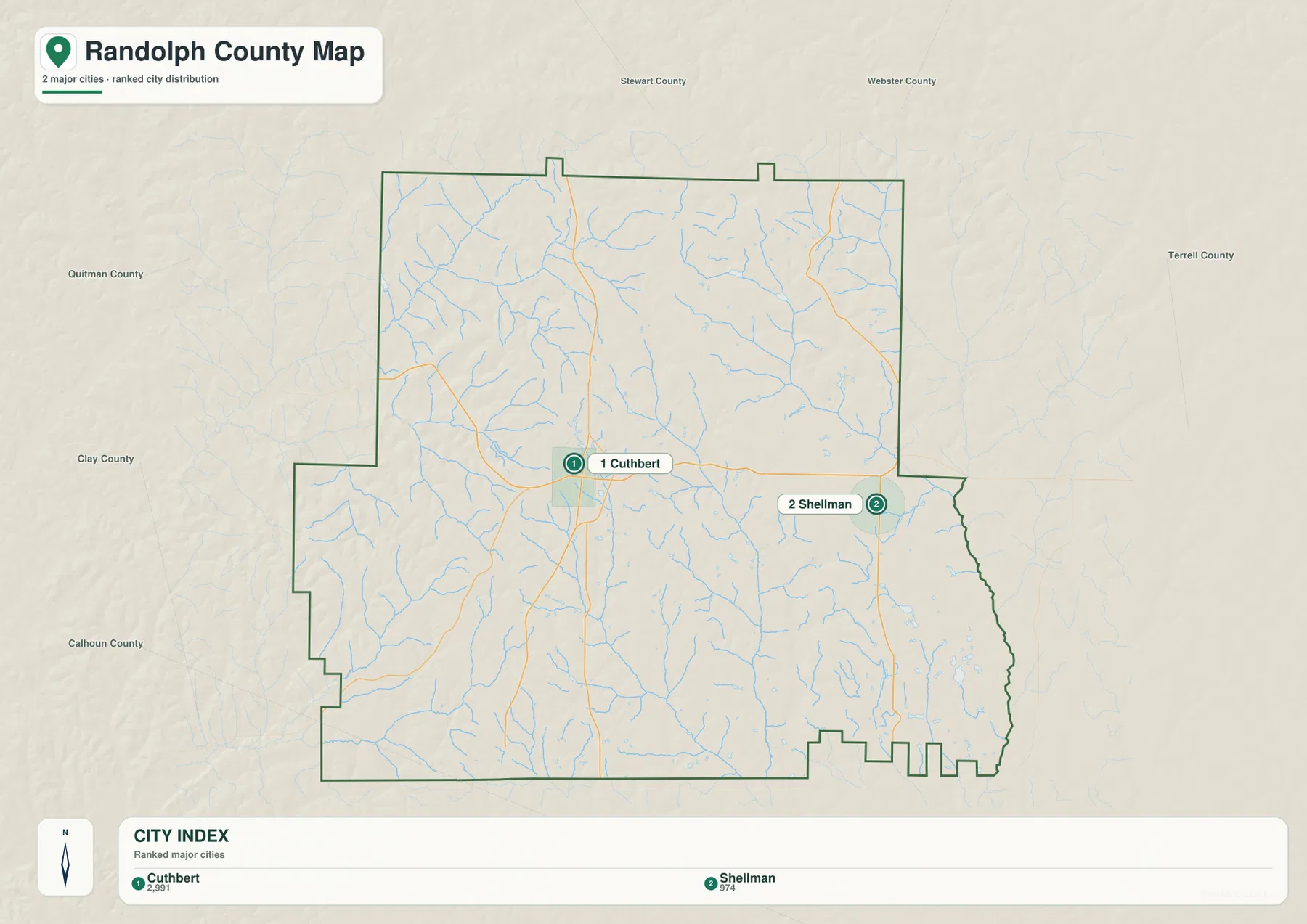
Cuthbert’s larger label and central road connections reinforce its role as the county’s main reference point. Shellman, by contrast, helps define the eastern side of the settled pattern. The map does not attempt to label every unincorporated community, crossroads, or small settlement. A place missing from this simplified city layer should not be interpreted as nonexistent; the purpose is to compare the principal named cities that are included in the supplied map.
The open space between the two city markers also becomes more meaningful after looking at the water map. Numerous small streams cross that interior area, and several north–south road segments cut across the drainage network. In other words, the county’s geography between Cuthbert and Shellman is not an empty gap. It is a landscape of rural roads, creek valleys, and rolling uplands that becomes much clearer when the thematic maps are read together.
Branching Creeks from Pataula to Ichawaynochaway
The terrain-and-water map shows a dense network of small waterways. Pataula Creek and Pumpkin Creek are labeled in the northern and northwestern part of the county. Farther east, Ichawaynochaway Creek and Little Ichawaynochaway Creek form prominent drainage lines. Town Branch, Goffs Mill Creek, Crater Creek, Hog Creek, Falling Creek, and other smaller tributaries add to the pattern across the central and southern sections.
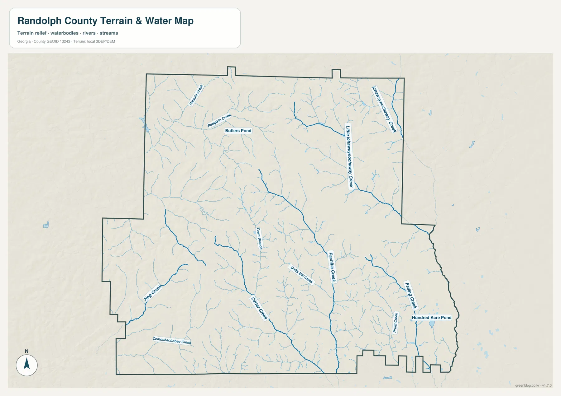
Two small waterbodies provide additional landmarks. Butlers Pond appears in the northern part of the county near Pumpkin Creek, and Hundred Acre Pond is labeled in the southeast. These ponds are not the dominant feature of the county, but they help show how surface water is distributed among many smaller drainage systems. The southeastern area also contains Falling Creek and several short tributaries that feed through lower terrain.
This map should be treated as a reference for the location and organization of waterways, not as a flood-hazard, parcel, legal-boundary, or navigation product. A creek shown here indicates the mapped hydrographic network, but it does not by itself describe flood probability, property rights, public access, or whether a channel is suitable for boating. Those questions require the appropriate current agency data.
Elevation from 64 to 177 Meters
The elevation map reports an actual county range of roughly 64 to 177 meters, with a mean of 119 meters. Randolph County is therefore not a mountain county, yet the shaded surface shows a noticeable difference between rolling uplands and drainage bottoms. Browns and tan colors are more common across parts of the north, north-central area, and west, while greener lower ground becomes more extensive toward the east and southeast.

Many of the green linear depressions match the creek valleys visible on the water map. The east and southeast contain broad areas of lower relief, while higher ridges and rounded uplands appear more frequently to the north and west. Small tributaries often begin among those higher areas and descend toward the larger creek lines. This is one of the clearest examples of why the water and elevation maps are more informative together than either map is by itself.
The elevation layer is generalized for county-scale comparison. It is useful for seeing relative highs, lows, ridges, and valleys, but it is not survey-grade elevation for a building site, drainage design, or engineering project. Anyone who needs a precise elevation for a particular property or structure should use current professional or agency data rather than reading a value from this shaded county surface.
What Becomes Clear When the Four Themes Are Compared
The road map establishes the main places and travel corridors first. The city map then removes much of the detail and makes the Cuthbert–Shellman pattern easier to see. The water map replaces the road emphasis with named creeks and tributaries, and the elevation map explains why many of those streams occupy long green valleys between higher ridges. Moving through the maps in that order turns a set of separate images into a connected picture of the county.
For example, an eastward look from Cuthbert toward Shellman begins with the road corridor, but the water layer reveals several drainage lines crossing the area in between. The elevation map then shows that many of those waterways sit in lower terrain. In the northwest, Pataula Creek and Pumpkin Creek lie among more strongly rolling ground, while the eastern side contains wider stretches of lower elevation. These are county-specific differences that are difficult to see from settlement labels alone.
Different readers may prefer different versions. The boundary-and-road map works well for a quick county locator, classroom handout, or general reference. The city map is cleaner when only the principal urban labels are needed. The water map is the best choice for naming creeks and small waterbodies, while the elevation map is the clearest visual for explaining hills and drainage valleys. The maps are complementary rather than interchangeable.
The WEBP images in the article are lightweight previews for the webpage. The downloadable archive contains the original high-resolution JPG versions. Because these maps are designed for general reference, use current authoritative sources for legal boundary decisions, surveying, engineering, flood analysis, or live navigation where a higher level of precision is required.
Frequently Asked Questions
Why does the city map emphasize only Cuthbert and Shellman?
The supplied ranked city map is intentionally simplified. Its index lists Cuthbert at 2,991 and Shellman at 974, so it is designed to compare the main cities shown rather than inventory every small community or crossroads in Randolph County.
How much elevation change is shown across Randolph County?
The map reports an actual range of about 64 to 177 meters and a mean of 119 meters. The higher rolling ground is more evident in parts of the north and west, while lower creek valleys are widespread toward the east and southeast.
Why are the webpage previews WEBP while the download files are JPG?
WEBP keeps the webpage previews smaller and faster to load. The ZIP contains four original high-resolution JPG files that are more convenient for printing, offline storage, and reuse in documents or presentations.
Sources and Reference Data
These sources provide background for county boundaries, hydrography, elevation, and county information.
- U.S. Census Bureau TIGER/Line Shapefiles
- USGS National Hydrography
- USGS 3D Elevation Program
- U.S. Census Bureau Randolph County QuickFacts
- New Georgia Encyclopedia – Randolph County
Map File Information
The download contains the four original high-resolution A3 JPG maps for Randolph County: the county map, ranked city map, terrain-and-water map, and elevation map. They are packaged together in one ZIP for printing, classroom use, presentations, and general geographic reference.
- File Type: JPG
Related Maps
Green Map creates custom-edited map images using open geographic data sources such as geoBoundaries, Natural Earth, OpenStreetMap, and government open data. These maps are edited visual materials, not raw data files, and are provided for education, documents, presentations, and graphic reference.