Butler County sits in north-central Iowa, where several small towns share the map rather than one large city dominating the county. Parkersburg, Shell Rock, Greene, Clarksville, Aplington, and Allison are spread across different parts of the county, while Iowa 3 and Iowa 14 provide two of the clearest reference lines for finding them. The terrain and water map adds another layer: the Shell Rock River crosses the eastern half of the county, the North Fork Cedar River runs across the south, and many smaller creeks cut narrow valleys through the uplands. The elevation map makes the contrast especially clear, with higher ground in much of the west and northwest and lower river corridors toward the east and south. The maps can be viewed on the page, and the high-resolution JPG versions are available in a downloadable ZIP for printing or close inspection.
A useful way to get oriented is to find Allison near the center and Parkersburg near the southern edge. Iowa 14 runs north from Parkersburg through the Allison area toward Greene, while Iowa 3 crosses the county from the Dumont side through Allison and Clarksville toward Shell Rock. These roads do not follow the major river valleys exactly, which makes the comparison between the road map and the terrain maps worthwhile. The Shell Rock River bends through the east, and the North Fork Cedar River forms a separate low corridor in the south. Reading the roads, towns, streams, and elevation together gives a much more complete picture of Butler County than any one map by itself.
Table of Contents
Use Allison and the Iowa 3–Iowa 14 crossroads to organize the county
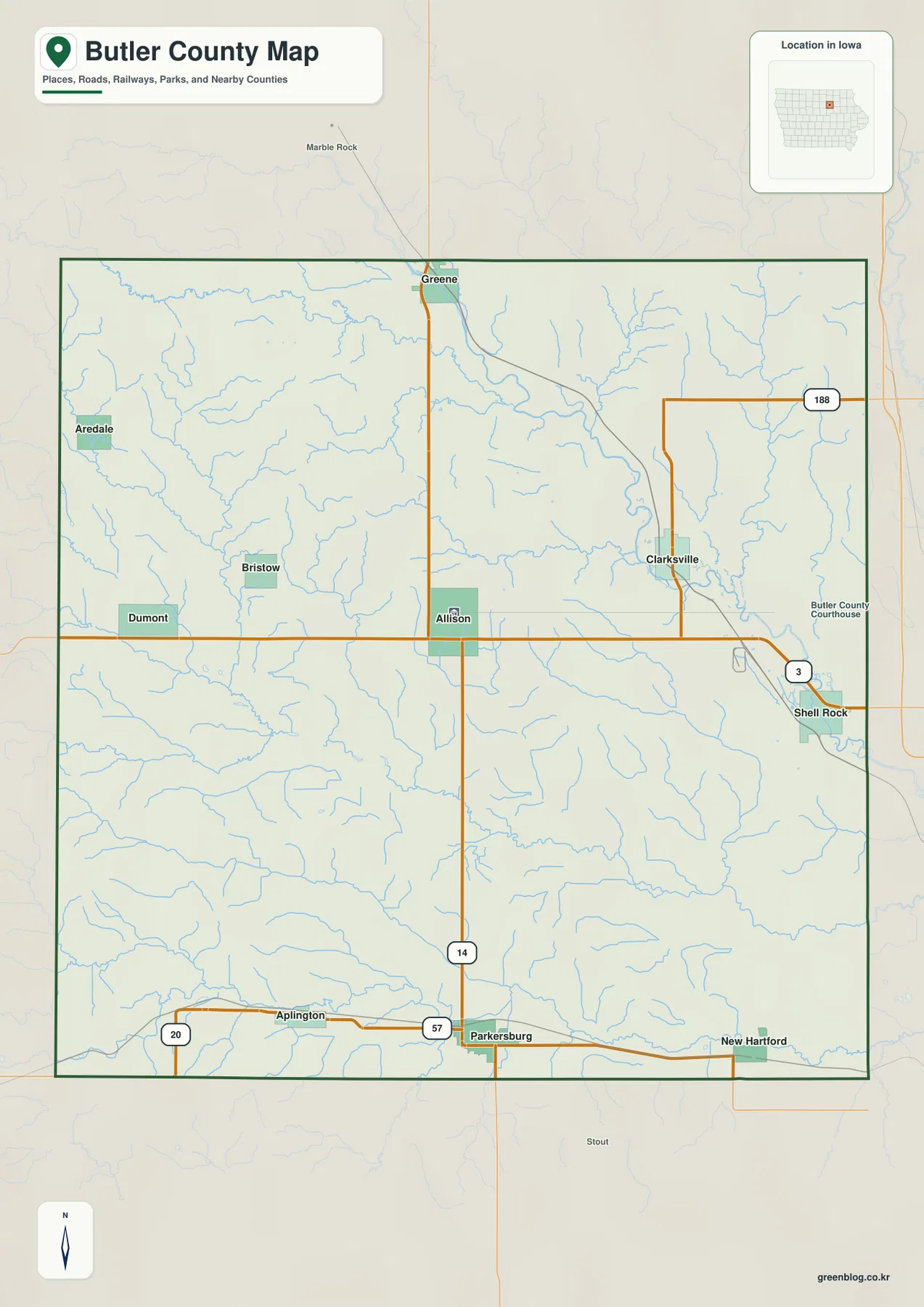
Allison appears close to the middle of Butler County, near the meeting of the county’s main east-west and north-south routes. Iowa 3 comes in from the west near Dumont, passes the Allison area, continues toward Clarksville, and reaches the eastern side near Shell Rock. Iowa 14 runs south from Greene, passes close to Allison, and continues toward Parkersburg. Finding these two highways first makes the rest of the county much easier to place because nearly every larger town can be described in relation to one of them.
Dumont and Bristow are in the western half, with Aredale farther north. Aplington lies in the southwest, while Parkersburg is close to the southern boundary. Clarksville occupies the northeast-central area, and Shell Rock sits close to the eastern edge. Greene is near the northern boundary. This distribution is important because Butler County does not have a single continuous urban corridor; instead, the towns are separated by farmland, creeks, and local road networks.
The county map also shows Iowa 188 in the northeast. In the southwest, U.S. 20 runs close to the county boundary west of Aplington, and Iowa 57 is visible along the southern route between the Aplington and Parkersburg area. The map is intended for county-level orientation rather than turn-by-turn driving. It emphasizes major roads, towns, boundaries, and the broader water network, so current road closures, construction, and local street routing should be checked with up-to-date transportation sources when travel details matter.
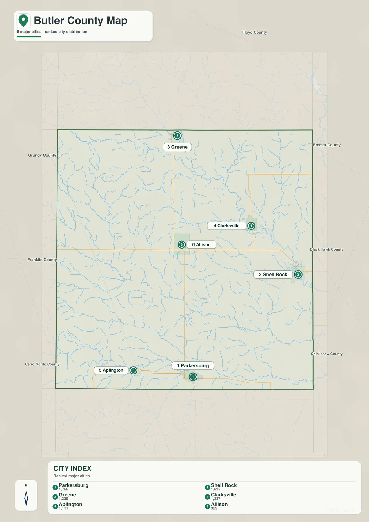
The six largest mapped towns are distributed across nearly every side of Butler County
The city map ranks six major towns: Parkersburg, Shell Rock, Greene, Clarksville, Aplington, and Allison. The index values printed on the map are 1,766 for Parkersburg, 1,625 for Shell Rock, 1,339 for Greene, 1,237 for Clarksville, 1,111 for Aplington, and 929 for Allison. These are values shown on the supplied map, not a newly calculated current population table. For an official population count tied to a specific year, a current Census dataset should be used instead.
What matters most here is the spatial pattern. Parkersburg, the first-ranked town on the map, is near the southern edge. Shell Rock is on the east side, Greene is in the north, Clarksville is in the northeast, Aplington is in the southwest, and Allison occupies a more central position. The towns therefore form a broad spread rather than a compact cluster. That makes the city map particularly useful for understanding why the county’s road network branches in several directions instead of focusing on one dominant urban center.
The contrast between city rank and location is also useful. Allison has the smallest index value among the six labeled cities, yet its central position makes it one of the easiest places to use as a geographic reference. Parkersburg has the largest value but is far from the center. Shell Rock is second on the list and sits beside the eastern river corridor. Comparing the city map with the county map shows why a settlement’s size and its usefulness as a map reference are not always the same thing.
Shell Rock River and the North Fork Cedar River define two major low corridors
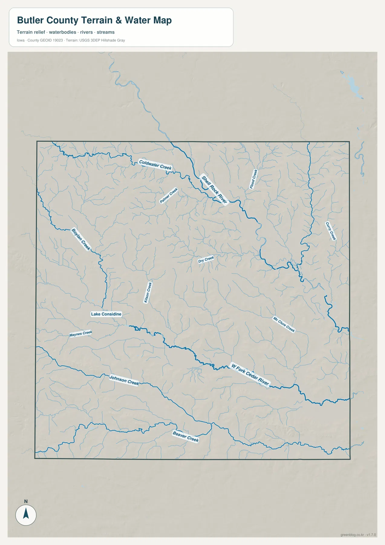
The Shell Rock River is the most prominent waterway on the terrain and water map. It enters from the north-central side, bends toward the east, and continues through the lower terrain around the Clarksville and Shell Rock side of the county. Coldwater Creek, Palmer Creek, and Flood Creek feed the same general drainage network. The main river and its tributaries create a branching pattern that stands out clearly against the surrounding uplands.
A separate system is visible in the south. The North Fork Cedar River runs broadly west to east, with Johnson Creek and Beaver Creek farther south following similar regional directions. Boylan Creek and Maynes Creek appear in the west, and Lake Considine is labeled near the southwestern drainage area. Dry Creek, Killion Creek, Hill Curve Creek, and Curl Creek add smaller channels through the center and east. The number of named tributaries helps explain why the relief map contains many narrow cuts instead of one smooth slope.
This water-reference map is designed to show the approximate location of rivers, streams, and terrain together. It is not a flood-hazard map, parcel map, legal water-boundary document, or navigation chart. Flood risk, bridge conditions, public access, water levels, and property boundaries require purpose-specific current information. For this page, the value of the map is in seeing where the major river corridors lie and how the smaller tributaries break the county into a series of valleys and ridges.
Elevation falls from western uplands toward the eastern river valleys
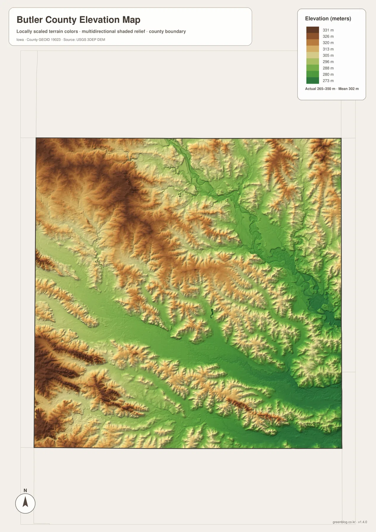
The elevation map lists an actual range of about 265 to 350 meters, with a mean near 302 meters. Higher colors cover much of the west and northwest, where brown and tan ridges extend across broad areas. Lower green terrain becomes more continuous toward the Shell Rock River corridor in the east and northeast. The difference is not dramatic mountain relief, but it is enough to make the major drainage valleys stand out clearly from the surrounding rolling ground.
The southern half has its own low corridor along the North Fork Cedar River. A long green band crosses the lower part of the county while yellow and brown ridges rise on both sides. In the center, smaller tributaries carve narrow green notches into moderately higher terrain. Comparing the elevation image with the water map shows that many of the low bands follow the same directions as the named rivers and creeks, making the relationship between drainage and local relief easy to see.
The colors are locally scaled for a county-wide overview. Brown does not mean mountainous terrain, and green does not automatically indicate wetland or flood hazard. The map is also not survey-grade elevation data. Engineering, drainage design, construction, and any task requiring exact point heights should rely on professional survey information or current high-resolution elevation data. This map is most useful for comparing broad high and low areas and identifying the main valley directions.
Follow Iowa 14 from Greene to Parkersburg to compare north and south
Iowa 14 creates a useful north-south transect through Butler County. Greene is close to the northern boundary, Allison lies near the middle, and Parkersburg is near the southern edge. On the county map this looks like a fairly straightforward transportation line, but the water and elevation maps show that the surrounding landscape changes repeatedly along the way. Northern tributaries, central creeks, and the low southern river corridor all cross or approach the route.
This makes Iowa 14 a good reference for explaining the county without relying on a long list of place names. Starting at Greene, moving through Allison, and ending near Parkersburg provides a simple geographic sequence. The elevation map adds the fact that nearby ridges and valleys do not remain at one level from north to south. The North Fork Cedar River becomes especially important near the southern part of the county, where the low green corridor runs across the map from west to east.
Clarksville and Shell Rock sit beside the county’s clearest eastern river landscape
Clarksville and Shell Rock are useful anchors for reading the eastern half of the county. Clarksville lies north of Iowa 3, while Shell Rock is closer to the eastern boundary. Between and around them, the Shell Rock River and several tributaries occupy a visibly lower part of the elevation map. The green valley floor contrasts with the higher western terrain and makes the eastern side one of the easiest places to connect settlement locations with natural topography.
The Shell Rock River does not travel in a straight line; it bends across the eastern drainage area and receives tributaries from several directions. That shape is much clearer on the terrain and water map than on the general road map. Looking at both maps together shows that Clarksville and Shell Rock are not simply eastern towns on a grid. They are part of a river-valley setting that continues toward neighboring Black Hawk County.
Choose the map by the question you need to answer
For town and highway orientation, begin with the county map. Find Allison, use Iowa 3 to establish the east-west direction, and use Iowa 14 to connect Greene with Parkersburg. Then add Clarksville and Shell Rock on the east side and Aplington in the southwest. The city map is the next useful step because it shows how the six major towns are spread across the county and how their ranked values compare.
For physical geography, reverse the order. Start with the terrain and water map, locate the Shell Rock River and North Fork Cedar River, and note where the smaller creeks join them. Then open the elevation map and compare the low green valleys with the higher tan and brown uplands. Returning to the county map afterward makes it easier to see which towns and highways sit close to the major river corridors and which lie on higher ground.
The WebP images in the article are convenient for quick viewing, while the JPG files in the download package are better for zooming and printing. The county, city, terrain/water, and elevation maps are provided as separate 3638 × 2572 pixel JPG images. That lets you use only the map that fits a lesson, presentation, local overview, or comparison instead of working from one crowded composite image.
County-wide reference maps and field-grade sources serve different purposes
These maps are designed to make the county’s overall geography easy to understand. They show major towns, important highways, prominent rivers and creeks, and broad elevation differences, but they do not include every local road, building, parcel, drainage ditch, or detailed contour. The water map should not be used to determine flood risk or legal water boundaries, and the elevation map is not a substitute for a survey. Legal, engineering, emergency, or property decisions require the appropriate current official source.
For county orientation, however, the simplified presentation is useful. Starting at Allison, tracing Iowa 3 and Iowa 14, comparing the eastern Shell Rock River with the southern North Fork Cedar River, and then checking the elevation colors provides a clear sequence for understanding how settlement, transportation, drainage, and relief fit together. Selecting the map that matches the question is more effective than trying to pull every detail from a single image.
Frequently Asked Questions
What is the easiest way to compare Parkersburg and Greene on the map?
Use Iowa 14 as the reference line. Greene is close to the northern boundary and Parkersburg is near the southern boundary along the same general north-south route. Allison lies between them near the county center, so it provides a useful third point for judging distance and direction.
Why does the Shell Rock River area appear lower on the elevation map?
The eastern Shell Rock River corridor is shown in lower green colors, while much of the west and northwest is represented by higher tan and brown terrain. Comparing the water and elevation maps shows that the main river and many tributaries follow lower valleys cut into the surrounding rolling uplands.
What is included in the downloadable ZIP?
The ZIP contains four high-resolution JPG files: the county overview, ranked city map, terrain and water map, and elevation map. Each JPG is 3638 × 2572 pixels, making the files more suitable than the page previews for zooming or printing.
Map File Information
The Butler County county overview, city map, terrain and water map, and elevation map are bundled as high-resolution JPG files. Download the ZIP when you need larger images for printing, presentations, or close map reading.
- Included Files: Use only the versions confirmed in the article and supplied images
- File Type: Use the confirmed download contents
- Intended Use: Printing, education, presentations, and map-based projects
Related Maps
Sources and references
For county administration and authoritative boundary, water, and elevation information, these official resources provide useful additional context.
- Butler County, Iowa – official county government information
- U.S. Census Bureau TIGER/Line Shapefiles – county boundaries, roads, and geographic reference data
- USGS National Hydrography – rivers, streams, and water features
- USGS 3D Elevation Program – elevation data
Green Map creates custom-edited map images using open geographic data sources such as geoBoundaries, Natural Earth, OpenStreetMap, and government open data.
These maps are edited visual materials, not raw data files, and are provided for education, documents, presentations, and graphic reference.