Lincoln County in eastern Georgia is easiest to understand as two connected landscapes. Around Lincolnton, roads spread through a rolling inland county, while the eastern side becomes increasingly shaped by the irregular shoreline and tributary arms of Clarks Hill Lake. The maps on this page separate those features into a county reference map, a city map, a water map, and an elevation map. You can use them to locate Lincolnton and major roads, trace named creeks toward the reservoir, compare higher inland ridges with lower stream valleys, and download all four maps as high-resolution A3 JPG files in one ZIP archive.
Lincolnton is the practical reference point for the county. On the general map it sits slightly west of center, where several numbered roads meet or pass nearby. The eastern and northeastern boundary looks very different: instead of a simple line across dry land, it follows a deeply indented reservoir edge with narrow water arms reaching inland. The elevation map adds a third layer to that picture, showing higher rolling ground in much of the west and lower terrain along creek valleys and near the lake. Looking across the four maps makes Lincoln County much more specific than a generic rural-county outline.
Table of Contents
Lincolnton Sits at the Center of a Small but Clear Road Network
| State | Georgia |
|---|---|
| County seat | Lincolnton |
| Places labeled on the county map | Lincolnton, Beulah, Bussey, and Amity |
| Road numbers visible | 44, 79, 220, 378, 47, and 43 |
| City map | Lincolnton is the single ranked major city |
| Elevation shown | Actual range about 99–260 m; mean 122 m |
| Download | Four high-resolution A3 JPG maps in one ZIP |
The county map makes the road pattern around Lincolnton easy to follow without turning the page into a full street map. Road 79 approaches from the north, 220 extends toward the northeast, and 378 runs away from the Lincolnton area toward the southwest. Road 47 appears farther southeast, 43 is shown near the southwestern edge, and 44 is labeled in the northwestern part of the county. These labels give readers a useful sense of direction and connectivity, even though the map is not intended to replace a current navigation service or a detailed state highway map.
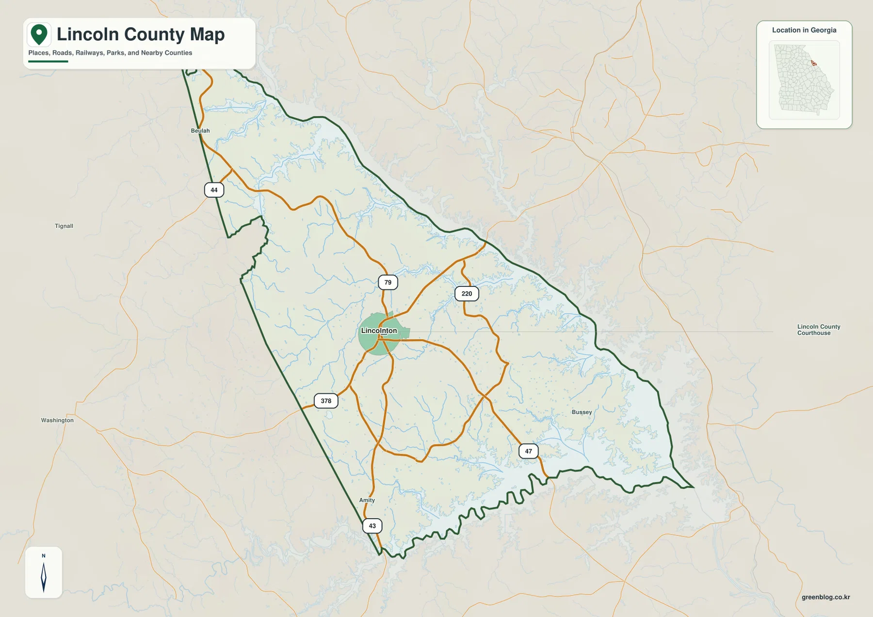
Beulah, Bussey, and Amity provide additional place references on the map. They should not be read as if they were all cities of the same size or legal status as Lincolnton; rather, they help identify the northern, eastern, and southern parts of the county. Outside the boundary, Washington and Tignall also appear as orientation points. This combination is useful when a reader wants to understand where Lincoln County sits in relation to nearby communities without loading the map with every local road and settlement.
The shape of the county changes noticeably from west to east. Much of the western edge is comparatively straightforward, but the east is cut by long reservoir inlets and shoreline bends. The southern boundary also becomes irregular where water and drainage valleys influence the outline. That contrast matters because it explains why a road-focused description works well around Lincolnton, while the eastern side is better understood by looking at creeks, lake arms, and relief.
One Ranked City Makes Lincolnton the Obvious Geographic Anchor
The city map is intentionally simple. It marks Lincolnton as the county’s one ranked major city and places a numbered marker at its location. The CITY INDEX shows Lincolnton as number 1 with the value 1,768. Because the preview does not state the reference year for that number, it is best treated as the population value used for the map’s ranking rather than as a claim about the latest official population. The important geographic point is that Lincolnton stands out clearly as the county seat and primary incorporated center on this map.
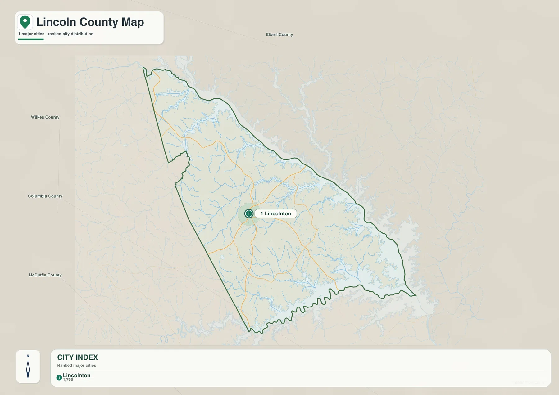
County names around the map help place that center in a wider setting. Elbert County is labeled to the north, Wilkes County to the west and northwest, Columbia County to the southwest, and McDuffie County farther southwest. The broad water area to the east gives that side of the map a very different appearance from the neighboring-county labels on the inland sides. For readers making a classroom map, a local-history graphic, or a county-location figure, this uncluttered city view can be more useful than a map filled with smaller communities.
The general map and city map therefore answer different practical needs. The county map is better when the road numbers, reservoir edge, and minor place labels matter. The city map is better when the goal is simply to show where Lincolnton sits inside the county and how Lincoln County relates to nearby counties. Using the simpler map for a simple question prevents the main location from being lost among extra labels.
Creeks Feed a Deeply Indented Clarks Hill Lake Shoreline
The water map changes the emphasis completely. Instead of roads and towns, it shows a dense network of tributaries draining toward the large reservoir system along the eastern side of Lincoln County. Fishing Creek is prominent in the north, while Curry Creek, Soap Creek, and Florence Creek cross the central and western interior. Farther east and southeast, Dry Fork Creek, Wells Creek, Shriver Creek, and Cherokee Creek run toward the reservoir. Graves Creek and Lloyd Creek appear in the southern part of the county, adding to a pattern in which many smaller valleys converge toward larger water bodies.
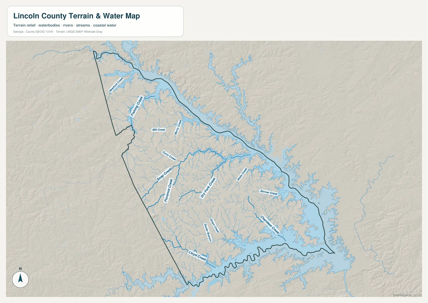
The reservoir edge is as important as the creek names. Long fingers of water reach inland from the east, creating a shoreline that is much more complicated than the county’s western boundary. Several tributaries terminate in these narrow lake arms, so the map shows repeated transitions from narrow stream channels to broader water. This makes the eastern half of the county easy to recognize even without road labels: the water geometry itself becomes a location reference.
Fishing Creek, Soap Creek, and Dry Fork Creek are especially useful for orienting a reader because they span different parts of the county. Wells Creek, Shriver Creek, and Cherokee Creek help explain the southeastern shoreline, where the reservoir has many inlets. Smaller named streams add detail but should not be confused with flood zones, navigable channels, legal wetland boundaries, or property lines. This map is a geographic reference to water locations; flood risk, boating conditions, water quality, and regulatory questions require the appropriate official data.
Clarks Hill Lake also appears in the existing county background as an important part of local recreation and regional identity. That context matches what the map shows: the lake is not a small feature at the edge of the page but a major element shaping the county’s eastern boundary. A reader who sees only the city map might think primarily about Lincolnton and a rural interior; the water map reveals how strongly the county is also tied to a large reservoir landscape.
Relief from About 99 to 260 Meters Separates Ridges from Stream Valleys
The elevation map reports an actual range of approximately 99 to 260 meters and a mean elevation of 122 meters. It does not depict a mountainous county, but it does show much more relief than a flat plain. Brown and tan areas identify relatively higher ground, especially across portions of the west and southwest, while green bands follow lower valleys. The pattern is finely divided: ridges and hollows repeat across the interior instead of forming one single high block and one single low block.
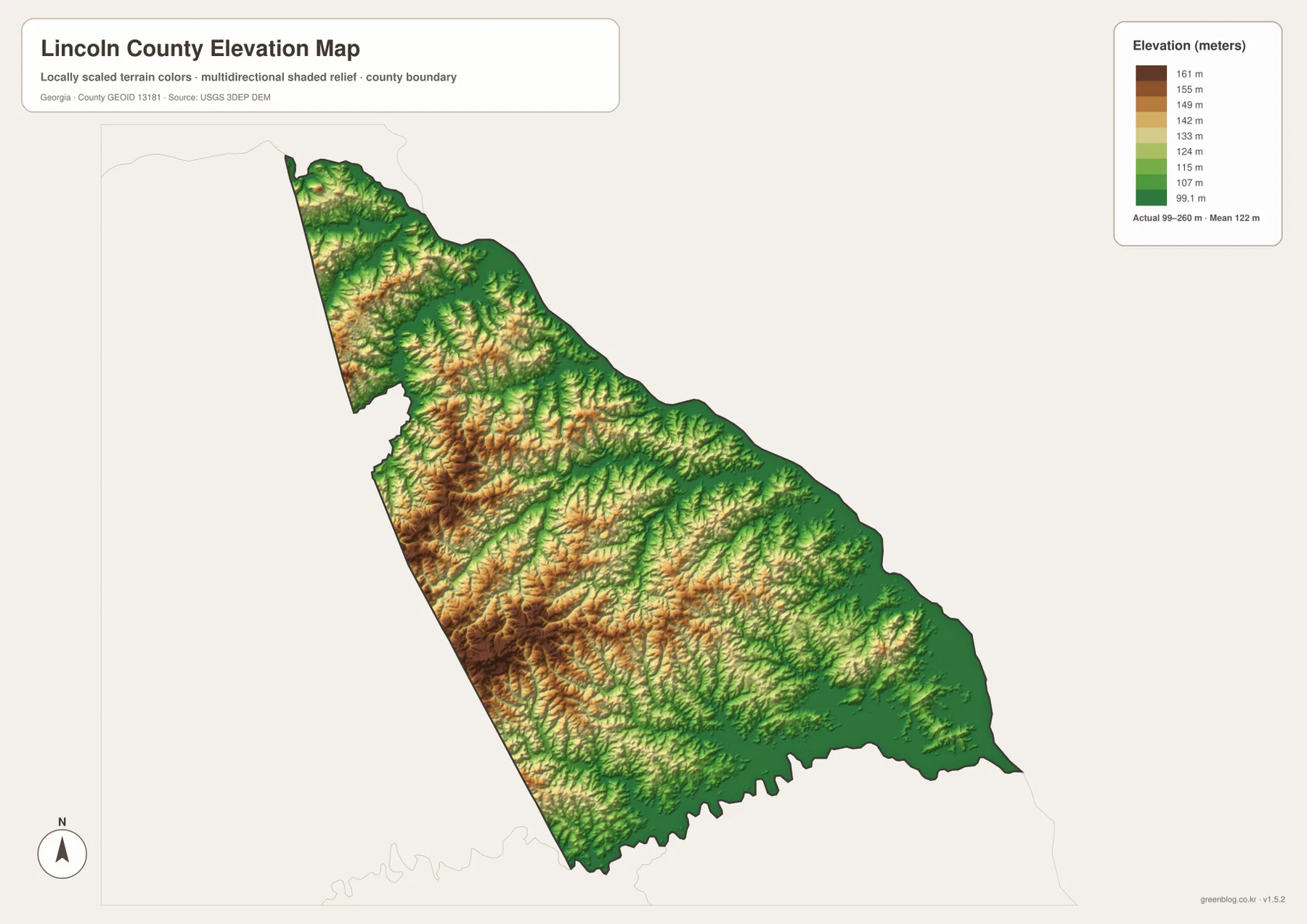
The eastern side becomes greener overall as the terrain approaches Clarks Hill Lake and its tributary arms. When the elevation map is compared with the water map, lower green corridors often align with the valleys occupied by creeks such as Fishing Creek, Soap Creek, Dry Fork Creek, and other tributaries. Higher ridges remain between those valleys. This relationship helps explain why the water network looks so branching: many small drainage paths descend through rolling terrain before reaching the reservoir.
The colors are scaled to make differences within Lincoln County visible, so they should not be compared mechanically with colors on another county’s map. A similar shade on two separately scaled maps does not guarantee the same elevation. The map is also not a survey product for a specific parcel. Its strength is county-wide comparison—showing which broad areas are relatively higher, where lower valleys cut through the ridges, and how the shoreline sits within the lower eastern terrain.
Comparing the Four Maps Reveals a Strong Inland-to-Lake Contrast
Each map becomes more useful when it is read with the others. The county reference map establishes Lincolnton, the numbered roads, and the unusual boundary. The city map strips the picture down to a single major urban reference. The water map shifts attention toward tributaries and the reservoir shoreline, while the elevation map explains the rolling ground and lower drainage valleys beneath that water network. Together they show a county that is centered administratively on Lincolnton but physically opens eastward into a heavily indented lake environment.
For a local geography assignment, the general map is a good starting image because it balances roads, places, and the county outline. A presentation focused on settlement patterns may need only the city map. The water map is the most informative choice for discussions of Clarks Hill Lake, creek names, or reservoir inlets. For terrain, watershed context, or a visual explanation of why streams occupy certain corridors, the elevation map works best beside the water map. Choosing the map that matches the question keeps the page readable and avoids forcing every label into a single image.
- County map: best for Lincolnton, Beulah, Bussey, Amity, road numbers, and the overall county outline
- City map: best for showing Lincolnton as the county’s single ranked major city and locating nearby counties
- Water map: best for Fishing Creek, Soap Creek, Dry Fork Creek, other tributaries, and the Clarks Hill Lake shoreline
- Elevation map: best for comparing the 99–260 m relief, higher western ridges, lower creek valleys, and the lake edge
The WEBP images in the article are optimized previews. The ZIP contains the larger JPG versions, which are more useful when you need to enlarge creek labels, inspect elevation shading, or prepare a printed reference. These maps are general geographic aids rather than legal or engineering documents, so current official sources should be consulted for parcel boundaries, surveying, flood hazards, regulatory decisions, or other high-precision uses.
Frequently Asked Questions
Where is Lincolnton within Lincoln County?
Lincolnton is located slightly west of the county’s center and serves as the county seat. The general map shows several numbered roads meeting or passing nearby, making Lincolnton the easiest point for orienting the inland road network.
Which named creeks are visible near Clarks Hill Lake?
The water map labels Fishing Creek, Soap Creek, Florence Creek, Dry Fork Creek, Wells Creek, Shriver Creek, Cherokee Creek, Lloyd Creek, and several other streams. Many of them drain toward narrow reservoir arms along the eastern and southern shoreline.
How much elevation change does the map show?
The elevation map lists an actual range of about 99 to 260 meters with a mean of 122 meters. Higher rolling ground is most visible inland, while lower corridors follow creek valleys and the reservoir side of the county.
What is included in the downloadable ZIP?
The ZIP contains four high-resolution A3 JPG files: the county map, city map, water map, and elevation map. The images shown in the article are WEBP previews, so the JPG files are the better choice for enlargement and printing.
Sources and Reference Data
The following sources provide county background and official reference data for boundaries, hydrography, and elevation. The maps on this page are designed for general geographic reference, so users making legal, surveying, regulatory, or safety decisions should consult the latest source datasets directly.
- U.S. Census Bureau QuickFacts – Lincoln County, Georgia
- New Georgia Encyclopedia – Lincoln County
- U.S. Census Bureau TIGER/Line Shapefiles – boundary data
- USGS National Hydrography – water data
- USGS 3D Elevation Program – elevation data
Map File Information
The download contains four high-resolution A3 JPG maps of Lincoln County: a county reference map, city map, water map, and elevation map. All four JPG files are packaged in one ZIP so you can choose the version that fits printing, classroom work, presentations, or closer on-screen inspection.
- Included Files: County Map JPG, City Map JPG, Water Map JPG, Elevation Map JPG
Related Maps
Green Map creates custom-edited map images using open geographic data sources such as geoBoundaries, Natural Earth, OpenStreetMap, and government open data. These maps are edited visual materials, not raw data files, and are provided for education, documents, presentations, and graphic reference.