Download the Talladega County Map as one ZIP containing four original A3 high-resolution JPGs: a county-and-roads map, a six-place ranked city map, a terrain-and-water map, and an elevation map. Talladega sits in the center as the county seat, Lincoln faces the northern I-20 corridor, Sylacauga and Childersburg form a southwestern group, and Munford lies closer to the higher eastern terrain. The Coosa River system borders the west while many smaller creeks drain the interior, so separating roads, settlements, water, and relief makes the county much easier to understand.
Talladega County is not organized around one compact urban center. Its communities belong to several different travel and terrain settings. Lincoln is close to I-20 and U.S. 78 in the north, Talladega is inland between the largest east-west corridors, and Sylacauga and Childersburg occupy the southwest. Munford is farther northeast near the ridge country. Looking at the four map types in sequence shows how those separated centers fit the county boundary rather than reducing the area to a list of place names.
Table of Contents
A long county connecting the I-20 north with the Sylacauga southwest
Talladega County lies in east-central Alabama. The supplied source material places Calhoun County to the north, Cleburne and Clay counties to the east, Coosa County to the south, and Shelby and St. Clair counties to the west. The county outline is far from rectangular: the Lincoln side bends strongly around the northwest, the eastern edge steps across the uplands, and the southwestern boundary follows a more irregular landscape near the Coosa system.
| State | Alabama |
|---|---|
| County | Talladega County |
| County seat | Talladega |
| 2025 population estimate | 81,603 |
| 2020 census population | 82,149 |
| Ranked-map places | Talladega, Sylacauga, Lincoln, Childersburg, Munford, Oak Grove |
| Major road references | I-20, U.S. 78, U.S. 280, AL 21, AL 77, and connecting routes |
| Water setting | Coosa River system and a dense network of interior creeks |
| Elevation shown | Actual 81-582 m, mean 187 m |
The existing county material gives a July 1, 2025 population estimate of 81,603 and a 2020 census count of 82,149. Those numbers provide useful scale, but the maps tell a more important geographic story: the county’s main communities are separated by long stretches of rural land, ridges, valleys, and water. Lincoln, Talladega, Sylacauga, and Munford do not belong to one continuous built-up strip, so road and terrain relationships matter as much as population totals.
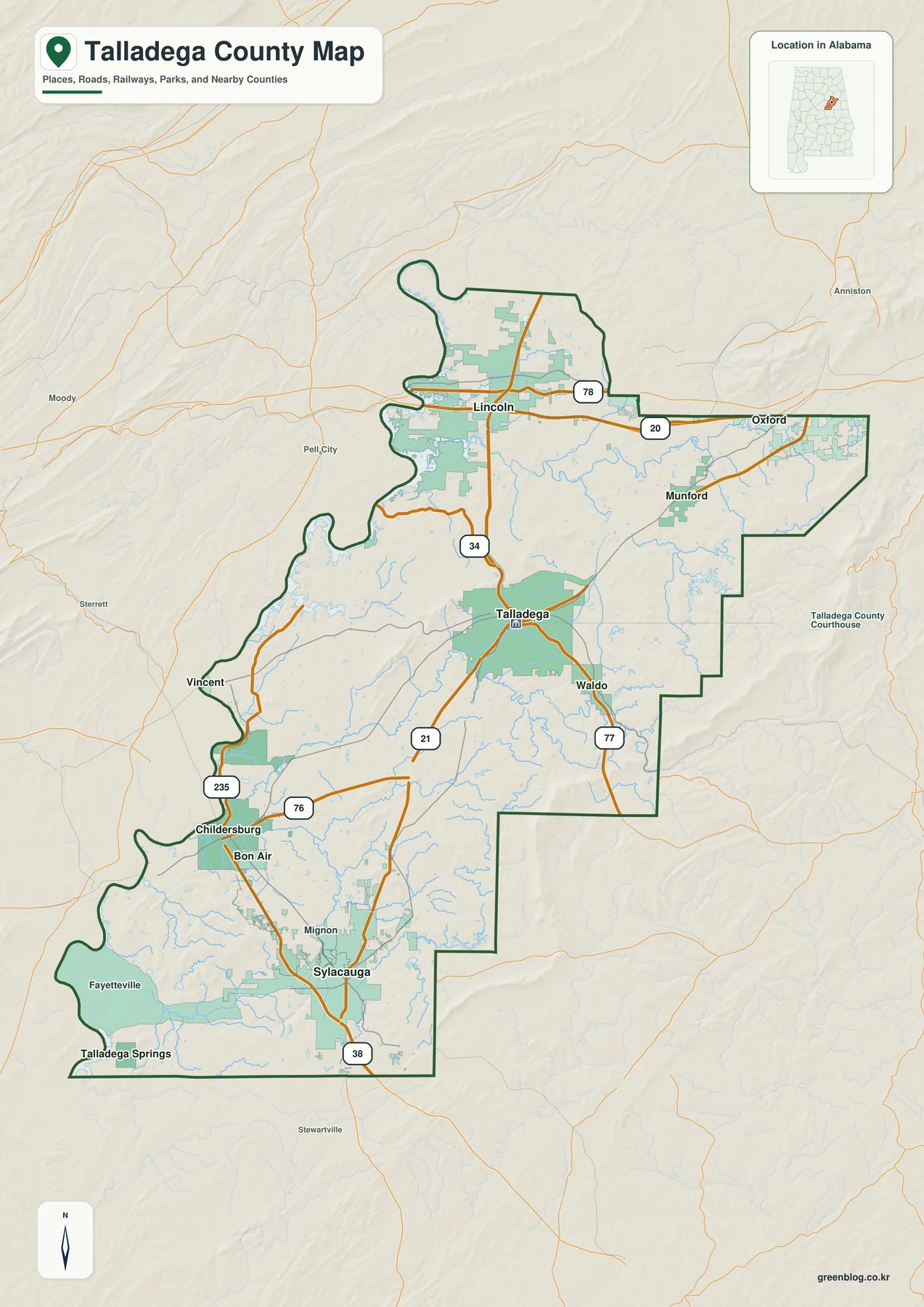
The clearest northern route is I-20 through the Lincoln side toward Oxford, with U.S. 78 providing another east-west reference nearby. Talladega is farther south in the interior, connected by Alabama 21, Alabama 77, and other state routes. Childersburg and Sylacauga form the strongest southwestern pair, with the supplied background identifying U.S. 280 as their major regional corridor. Route numbers such as 34, 76, 235, and 38 on the general map help fill in the connections between the larger highways and individual communities.
Six ranked places show separate northern, central, and southwestern centers
The ranked city map selects six places and prints a comparison value beside each. Talladega is first at 14,760 and Sylacauga second at 12,309. Lincoln follows at 7,305, Childersburg at 4,655, Munford at 1,508, and Oak Grove at 856. These are the values printed on the supplied map and are best used to compare its selected places rather than to replace a separately dated population table.
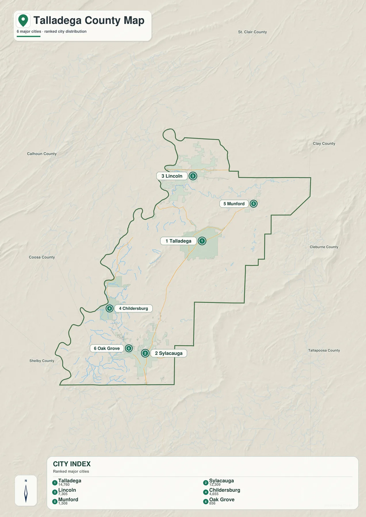
Talladega’s top rank pairs naturally with its county-seat role, but Sylacauga is also a major center and lies well to the southwest. Lincoln occupies another setting entirely, close to the interstate and the western water landscape. Munford sits near the northeastern uplands, while Childersburg and Oak Grove belong to the southwestern side. The city graphic therefore works as a regional comparison as much as a size ranking.
The six labels are not a complete municipal inventory. The general map also shows Waldo, Vincent, Bon Air, Fayetteville, Talladega Springs, and other place names. Use the ranked map when the goal is to simplify the settlement pattern; return to the general map when smaller communities, route numbers, or the relationship to the county edge matters.
The places also represent different local roles in the supplied background. Talladega contains county government and public institutions, Sylacauga is long associated with its marble belt, and Lincoln is linked with automotive manufacturing and the Talladega Superspeedway area. Those functions are distributed across different parts of the county, which is another reason the map should not be read as a single-center urban area.
The Coosa River side contrasts with a dense network of interior creeks
The dedicated water map makes the western side of Talladega County look very different from the interior. Broad Coosa River water appears along and beyond the county edge, while narrow tributaries branch repeatedly across the county. The existing article connects the Lincoln side with Logan Martin Lake and describes the Childersburg side as part of the lower Coosa and Lay Lake system. Those larger waters help explain why the western outline bends so strongly in places.
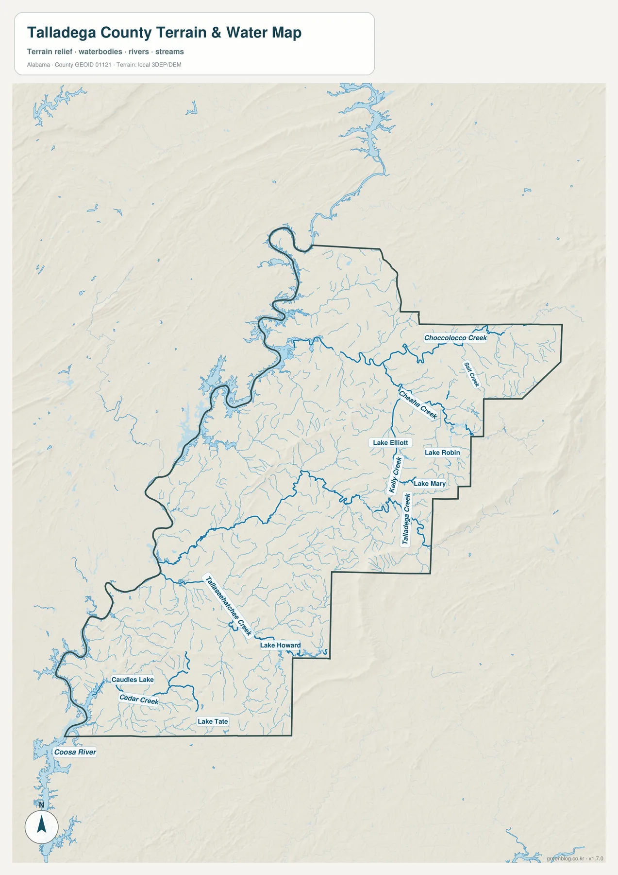
Choccolocco Creek is one of the clearest named waterways in the northeast, with Big Creek and many smaller branches nearby. Farther south, Cheaha Creek crosses the eastern interior near Lake Elliott, Lake Robin, and Lake Mary. Talladega Creek extends through the central and southeastern part of the map. Cedar Creek and Caudles Lake provide southwestern references, while Lake Tate and Lake Howard add smaller named waters that are easy to miss on the general map.
The water layer also helps distinguish the communities. Lincoln is close to the broad Coosa reservoir landscape, while Talladega and Munford are surrounded more strongly by creek-filled valleys. Sylacauga and Childersburg have dense smaller drainage in the interior but move toward the larger Coosa system on the west. The pattern is therefore not simply one river along one edge; a large regional waterway and many local tributaries work together.
This is a geographic water-reference map, not a flood-risk or legal-boundary product. It is useful for locating rivers, creeks, and lakes, for classroom work, and for adding water context to local research. Floodplain decisions, parcel drainage, legal shoreline questions, or navigation require more specialized current data.
Elevation climbs sharply toward the eastern ridge country
The elevation map provides the strongest visual contrast in the package. Its legend reports an actual county range from 81 to 582 meters and a mean of 187 meters. Low green terrain dominates much of the western Coosa side and parts of the interior. Along the eastern boundary, however, long brown and tan ridges rise sharply, with additional smaller ridge bands appearing through the center and southwest.
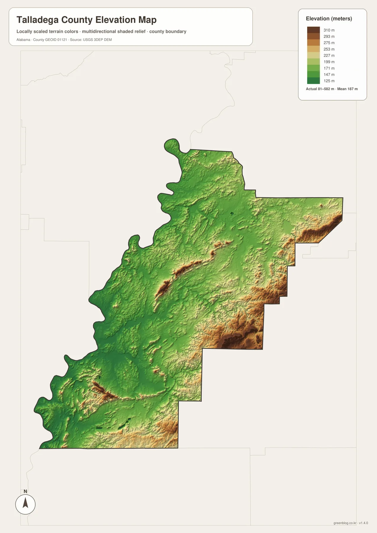
The supplied background places northeastern and eastern Talladega County in the southern Appalachian Valley and Ridge setting, with the southwest grading toward Piedmont terrain. It also identifies Talladega National Forest as an important part of the eastern mountain landscape. The relief image matches that description: the eastern high ground forms elongated ridges and the streams tend to occupy lower valleys between them.
Munford lies closest to the northeastern high country, while Talladega sits within lower interior terrain. Sylacauga and Childersburg are not in the highest mountain band, yet the southwest is still rolling rather than uniformly flat. Moving toward the Coosa side generally brings lower ground. These differences give useful context to the curves and gaps visible in the road network.
The elevation layer is intended for countywide comparison, not survey-grade measurement. It works well for showing where the high ridges are, how the eastern uplands differ from the river side, and why road travel does not follow a simple grid. Parcel elevations, construction design, engineering, or precise surveying require more detailed source data.
I-20 in the north and U.S. 280 in the southwest create different travel patterns
I-20 and U.S. 280 should be treated as separate regional references. I-20 serves the Lincoln side and links the county toward Birmingham to the west and Oxford, Anniston, and Georgia to the east. U.S. 280 serves the Sylacauga-Childersburg side and connects the southwest with a different Birmingham-facing route. Talladega lies inland between those large corridors, so the county seat is not simply an interchange community on either one.
Alabama 21 and Alabama 77 are more useful for understanding north-south movement around Talladega itself. The general map shows routes continuing toward Waldo and Sylacauga as well as connections north toward Lincoln. Munford’s northeastern position is more strongly influenced by the ridge country and the creek valleys shown on the other maps. Comparing road and relief layers explains why a short straight-line distance can still involve a winding route.
Childersburg and Sylacauga form a recognizable southwestern pair, but their surroundings combine rolling interior terrain with access toward the Coosa water side. Lincoln combines a large water setting with the interstate corridor. Talladega is defined by its administrative role and central road connections, while Munford is the strongest eastern-upland reference among the six ranked places. Those distinctions are more useful than treating the county as a single travel market.
Choose the Talladega County map that matches the detail you need
Use the general county map when boundaries, major roads, towns, and nearby context need to remain visible together. It is the best all-purpose reference for locating Lincoln, Talladega, Munford, Childersburg, and Sylacauga while keeping the county outline and road system in view. The ranked city map is faster when the main task is simply to compare the six selected places and see how they are distributed.
Choose the water map when the Coosa River, Choccolocco Creek, Cheaha Creek, Talladega Creek, Cedar Creek, or smaller named lakes are the main interest. Choose the elevation map when terrain matters more than labels. Its clearest message is the sharp contrast between the high eastern ridge country and the much lower western Coosa side, with rolling relief continuing through the interior and southwest.
For teaching, printing, regional comparison, or a personal map project, the four files work well as complementary references. Start with position and roads, simplify the settlement pattern with the ranked map, then add water and relief when the physical landscape becomes important. Keeping the subjects separate makes each map easier to read while still allowing the set to describe the county in considerable detail.
Frequently Asked Questions
Which place ranks first on the supplied city map?
Talladega ranks first at 14,760, followed by Sylacauga at 12,309. Lincoln, Childersburg, Munford, and Oak Grove complete the six-place ranking. The values are those printed on the map and should be used for comparison rather than as a complete list of county communities.
Where is the Coosa River system in relation to Talladega County?
The broad Coosa system lies mainly along the western and northwestern/southwestern side of the county. The supplied background links the Lincoln area with Logan Martin Lake and the Childersburg side with the downstream Coosa and Lay Lake system, while numerous interior creeks drain toward the larger waterway.
Where is the highest terrain shown on the elevation map?
The strongest high ground is along the eastern side of Talladega County. The map reports an actual range of 81 to 582 meters and a mean of 187 meters. Lower terrain is much more common toward the western Coosa side, while smaller ridges continue across parts of the center and southwest.
Map File Information
Talladega County map files
- Included Versions: county, city, water, elevation
Related Maps
- Abbeville, Headland, and Lake Eufaula on the Henry County Alabama Map
- Athens to Wheeler Reservoir on the Limestone County Alabama Map
- Autauga County Map
Sources and references
- U.S. Census Bureau — 2020 Census and Vintage 2025 population background
- Encyclopedia of Alabama — Talladega County history, communities, terrain, and water context
- U.S. Forest Service, National Forests in Alabama — Talladega National Forest background
- Alabama Department of Transportation — highway and county-road reference
- USGS National Hydrography — water-feature reference
- USGS 3D Elevation Program — elevation reference
Green Map creates custom-edited map images using open geographic data sources such as geoBoundaries, Natural Earth, OpenStreetMap, and government open data. These maps are edited visual materials, not raw data files, and are provided for education, documents, presentations, and graphic reference.