Henry County in southeast Alabama is easiest to understand by following three features: Abbeville near the middle of the county, Headland on the U.S. 431 route toward Dothan, and the Chattahoochee River along the Georgia side. This page includes four complementary maps, and you can download the A3 high-resolution JPG set as one ZIP from the map file box below.
The maps do not all answer the same question. The county map is best for roads, places, and the boundary; the city-connections map uses Headland as a distance hub; the water map brings small creeks into view; and the elevation map shows how low river valleys cut through higher rolling ground. Used together, they explain why Henry County feels different along the Dothan-facing south, around the Abbeville government center, and beside the Georgia border.
Table of Contents
Abbeville, U.S. 431, and the county boundary
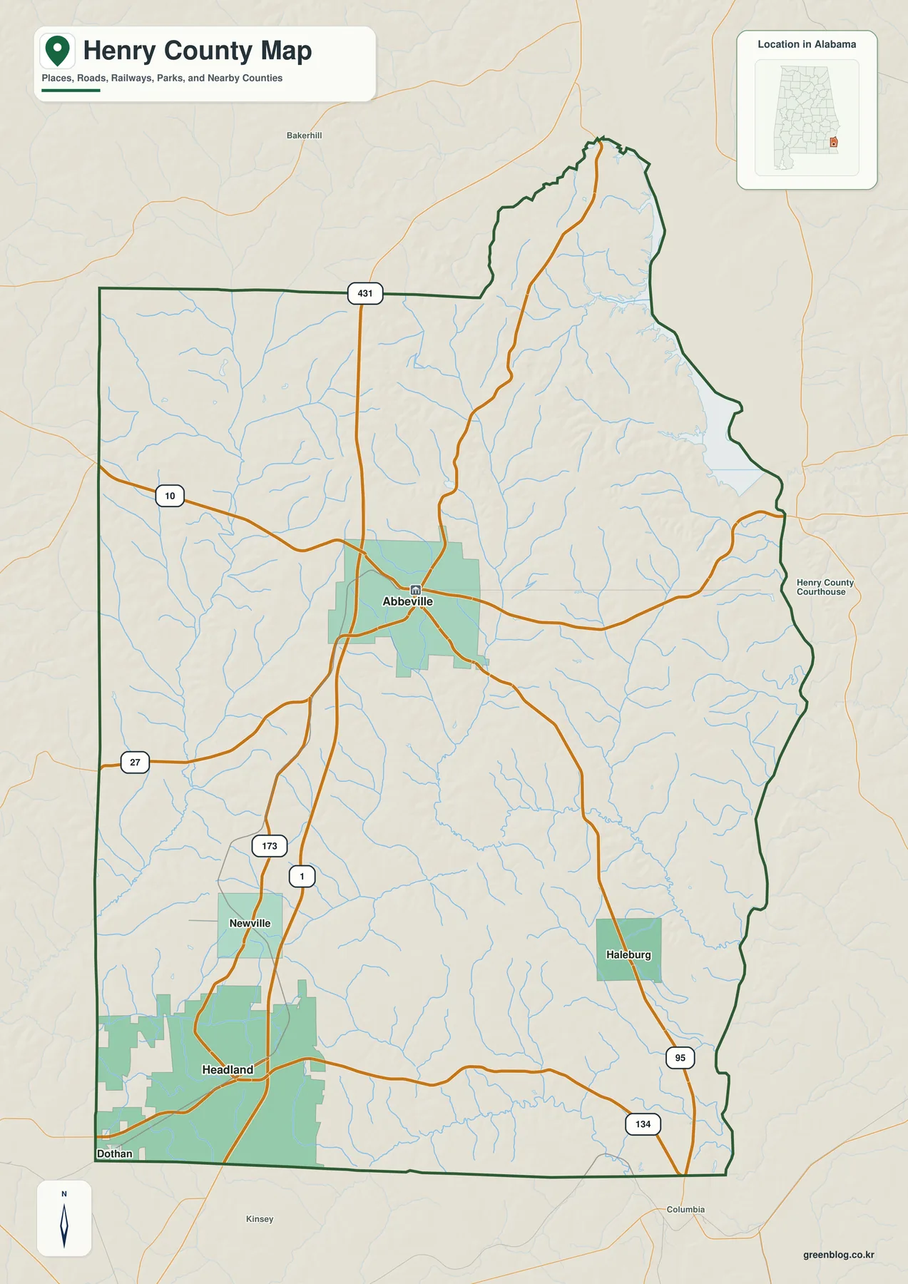
Abbeville is the county seat and the clearest starting point on the main county map. U.S. 431 runs north-south just west of the city before continuing toward Headland and Dothan, while Alabama 10 crosses the county seat from west to east. Those two routes give the middle of Henry County a simple reference frame even though the rest of the road network branches in several directions.
Headland fills a larger urban area in the southwest and sits close to the Dothan side of the county. Dothan itself is labeled at the southwest edge because part of the city reaches the Henry County boundary and because it is the major nearby service center. The label should not be read as a fifth equivalent Henry County municipality: Abbeville, Headland, Newville, and Haleburg are the four incorporated municipalities listed in the supplied county material.
Newville lies north of Headland on the western side, while Haleburg is farther east near Alabama 95. Alabama 27, 134, and 173 add useful local connections, so the map works well for seeing which roads meet each community. Alabama 134 crosses through the Headland area, and Alabama 95 provides a north-south reference on the southeast side near Haleburg.
The county meets Dale County on the west, Houston County on the south, Barbour County on the north, and Georgia on the east. The eastern outline is much less regular than the western and southern sides because it follows the Chattahoochee River and reservoir shoreline. That is one reason the water map is especially useful here: the boundary makes more sense when the river is visible.
| State | Alabama |
|---|---|
| County | Henry County |
| County seat | Abbeville |
| Incorporated municipalities | Abbeville, Headland, Newville, Haleburg |
| Main mapped routes | U.S. 431; Alabama 10, 27, 95, 134, 173 |
| Key mapped waters | Chattahoochee River, Abbie Creek, East Fork Choctawhatchee River |
| Elevation shown | About 31–167 m; mean about 99 m |
The supplied QuickFacts material lists a July 2025 population estimate of 18,394 and a 2020 census count of 17,146. The numbers are useful background, but the maps show something the totals cannot: settlement is not spread evenly. Abbeville remains the government center, Headland has the strongest connection to the Dothan side, and Newville and Haleburg serve much smaller rural areas.
Why Headland is the hub on the city-connections map
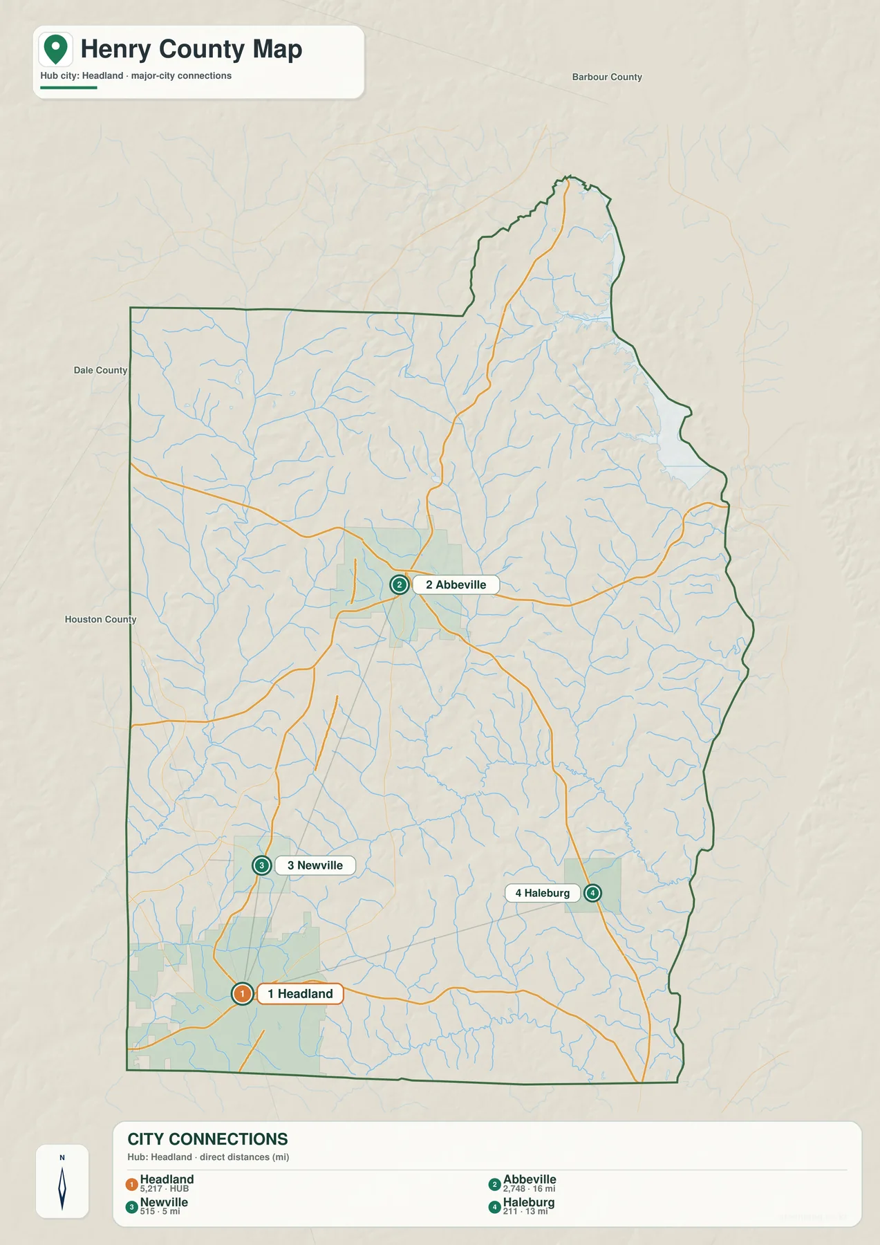
The city-connections map deliberately uses Headland as its hub. That does not change the county seat; Abbeville is still the administrative center. Headland is simply a practical comparison point because it is the largest of the mapped Henry County municipalities and sits close to U.S. 431 and the Dothan area.
From Headland, the map shows Abbeville at about 16 miles, Haleburg at about 13 miles, and Newville at about 5 miles. These are straight-line distances, not driving mileage. A road trip can be longer because roads curve, cross streams, or approach a town from a different direction, so the figures are best used for relative position rather than travel time.
Newville is the closest of the three numbered destinations and lies just north of Headland. Abbeville is farther north and slightly east, while Haleburg sits to the east. The layout makes it clear that Henry County’s towns are dispersed rather than packed into one continuous urban belt. Headland may be the hub for this map, but it is still separated from the county seat by a substantial stretch of rural land.
The contrast between the city map and the county map is also useful for understanding Dothan. Dothan appears on the broader county map at the southwest edge, but it is not given one of the four numbered Henry County municipality markers. Read the two maps together and the reason becomes clear: Dothan is an outside regional center that strongly influences the south, while the numbered places are the county’s own incorporated municipalities.
The supplied local material adds historical context to that pattern. Abbeville was established in 1823 and has retained the courthouse and county offices. Headland developed later in the nineteenth century and today benefits from its position on U.S. 431. East of Headland, the Wiregrass Research and Extension Center also reflects the agricultural setting that still surrounds the county’s towns.
Chattahoochee water on the east, Choctawhatchee drainage on the west
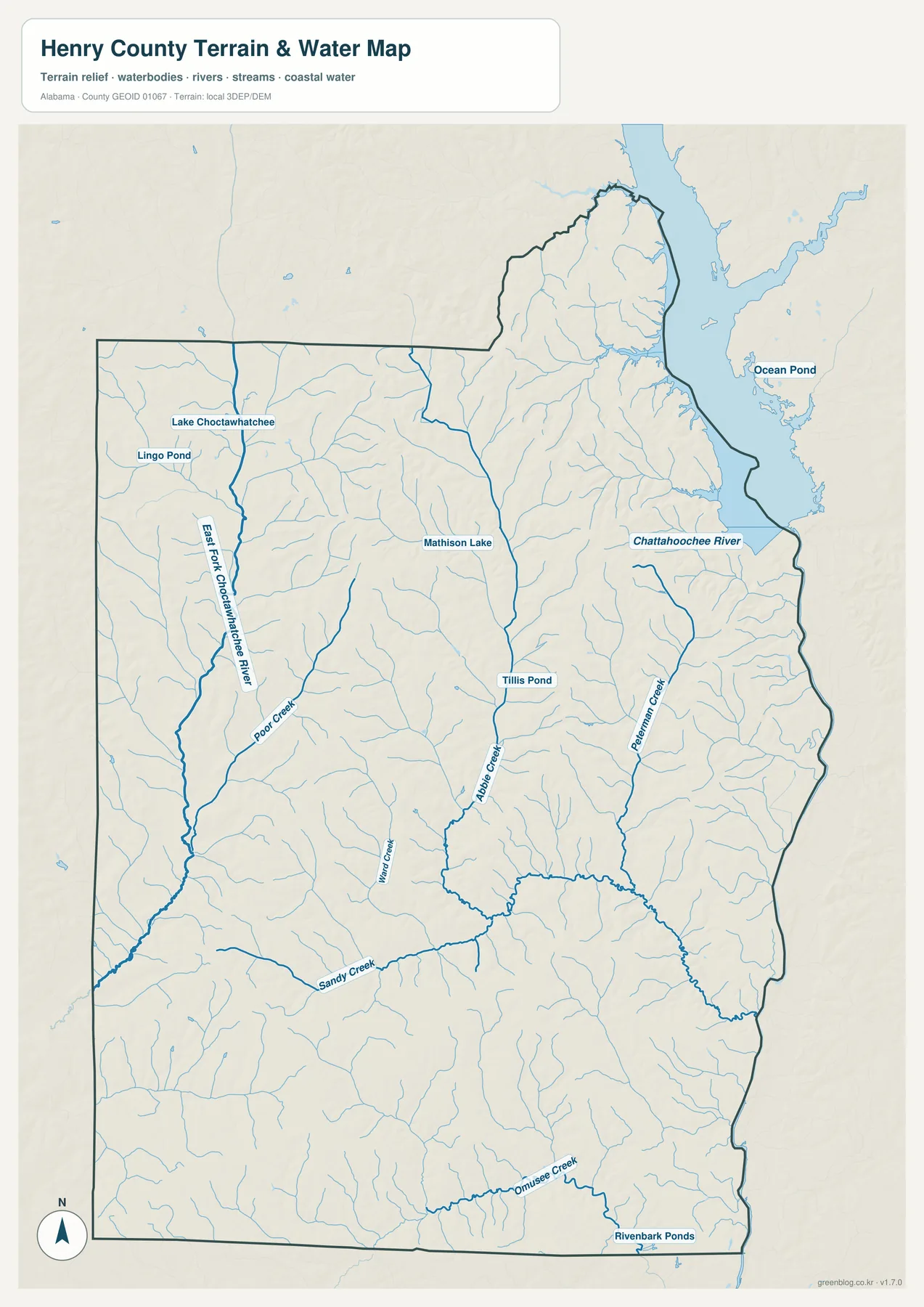
The eastern side of Henry County is defined by the Chattahoochee River and the broad reservoir reach associated with Lake Eufaula. Instead of a straight state line, the Alabama–Georgia edge bends with coves, tributary mouths, and the river channel. On the county map that shape is visible as a complicated boundary; on the water map the reason for it becomes obvious.
Abbie Creek is one of the most prominent inland streams on the map. It runs from the central part of the county toward the Chattahoochee side, joined by smaller branches. Peterman Creek is labeled farther east, and the map also shows many unnamed tributaries that fill what would otherwise look like empty rural space on a standard road map.
The western half tells a different water story. The East Fork Choctawhatchee River is clearly labeled, with Poor Creek and other branches feeding the network. Sandy Creek crosses the lower middle of the county. This means the county’s waterways do not all point toward the Georgia border; a substantial group of streams on the western side belongs to the Choctawhatchee drainage instead.
Smaller named waters, including Mathison Lake, Tillis Pond, and Lingo Pond, make the map useful at a more local scale. They are not substitutes for parcel or navigation data, but they help a reader match community roads with nearby creeks and ponds. The map should also not be treated as a flood-risk map: it shows where water features are, not how far floodwater may spread.
Lake Eufaula is described in the supplied Outdoor Alabama source as a reservoir of roughly 45,181 acres created by Walter F. George Dam. For Henry County, the importance is geographic as much as recreational. The river and reservoir form a long, water-defined edge, so eastbound roads approach the Georgia line through a landscape with fewer direct crossing opportunities than a simple straight boundary would suggest.
Elevation from 31 to 167 meters: creek valleys between rolling ridges
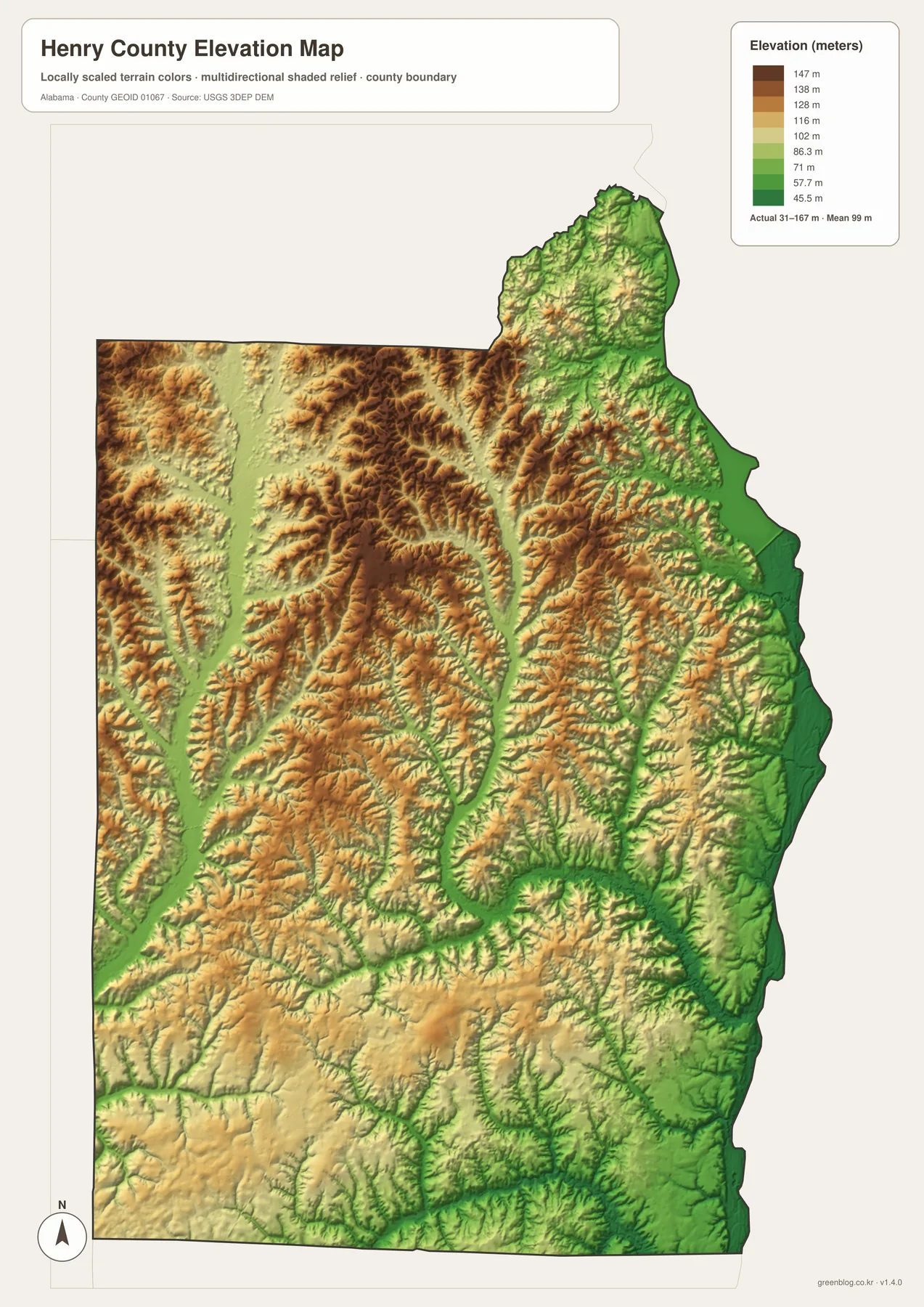
The elevation map gives Henry County an actual displayed range of about 31 to 167 meters, with a mean near 99 meters. There are no high mountains, but the county is not a flat sheet. Narrow stream valleys repeatedly cut through higher rolling ground, producing a textured pattern that is easy to miss on a simple boundary map.
Some of the lowest ground lies along the Chattahoochee side, where green shades follow the eastern river corridor. Other low bands run through the interior and western half along creek valleys. Between those bands, yellow, tan, and brown ridges rise above the drainage lines. The pattern is especially clear when the elevation image is compared directly with the water map.
The northern and central interior contains many short ridges and branching valleys, while parts of the south appear gentler. Even there, however, individual creeks cut lower paths across the landscape, so a simple north-high/south-low rule would be misleading. The useful takeaway is that elevation changes locally from one creek valley to the next.
This map is intended for regional reference, schoolwork, planning a visual presentation, or comparing terrain with roads and streams. It is not survey-grade elevation data and should not be used for engineering decisions. Its strength is the broad picture: low water corridors, rolling uplands, and the sharp drop toward the eastern river edge can all be seen at once.
Choose the map that matches the job
For a quick location reference, start with the county map because it combines the boundary, labeled places, roads, and streams. Use the city-connections map when relative town positions matter more than highway detail. The water map is better for tracing creeks and the Chattahoochee edge, while the elevation map is the clearest choice for explaining why the county contains both low river corridors and rolling interior ground.
- County map: best for Abbeville, Headland, Newville, Haleburg, major routes, and the county outline.
- City-connections map: best for straight-line distance and direction from Headland to the other Henry County municipalities.
- Water map: best for the Chattahoochee River, Abbie Creek, East Fork Choctawhatchee River, and smaller ponds and tributaries.
- Elevation map: best for the 31–167 meter relief range, creek valleys, and higher rolling ground.
The files can be useful for classroom handouts, county reference sheets, travel planning at a broad scale, presentations, or personal map collections. Print users will get the most detail from the original JPGs rather than the smaller web previews. The four files are packaged together so you can keep the same county extent while switching between road, city, water, and elevation information.
Frequently Asked Questions
Why is Headland the hub on the city-connections map?
Headland was selected as the comparison point for the city map; it is not the county seat. Abbeville remains Henry County’s government center. The map measures straight-line distance from Headland to Abbeville, Newville, and Haleburg so their relative positions can be compared quickly.
Why is Dothan labeled on the broader county map?
Dothan is mainly in Houston County, but it reaches the Henry County edge and is the major nearby regional center for the southern part of the county. Its label helps explain Headland’s position and the importance of U.S. 431. It is not presented as one of the four numbered Henry County municipalities on the city-connections map.
Can the water map be used as a flood map?
No. It is a reference map for rivers, creeks, ponds, and other mapped water features. It does not show flood probability, expected flood depth, property ownership, or navigational status. Those questions require the appropriate official datasets for each purpose.
Map File Information
Henry County A3 map files
- Included Files: Four JPG map files provided with this article
- File Type: ZIP archive of JPG files
- Intended Use: Printing, education, presentations, and map-based projects
Related Maps
Sources and reference data
- U.S. Census Bureau QuickFacts – Henry County, Alabama for population and land-area background
- Henry County official cities and towns information for local municipality reference
- ALDOT Highway Functional Classification Maps for road-network reference
- USGS National Hydrography for river and stream reference
- USGS 3D Elevation Program for elevation reference
- Outdoor Alabama – Lake Eufaula for reservoir background
Green Map creates custom-edited map images using open geographic data sources such as geoBoundaries, Natural Earth, OpenStreetMap, and government open data. These maps are edited visual materials, not raw data files, and are provided for education, documents, presentations, and graphic reference.