A Coosa County Map becomes much easier to use when Rockford, Goodwater, the western reservoir shore, and the county’s ridged interior are treated as a few clear reference points. Coosa County lies in central Alabama and is made up largely of small towns, rural communities, wooded uplands, creek valleys, and long stretches without dense urban development. The maps on this page separate those details so you can locate roads and named places, compare the main municipalities, follow lakes and streams, and see how elevation changes across the county. If you need larger files for printing or projects, the page also provides a ZIP download with four high-resolution A3 JPG maps.
Rockford sits near the middle of the county and makes a useful starting point. Goodwater is much farther northeast, Kellyton lies on the eastern side, and the western border is shaped by the narrow arms of Lay Lake and Mitchell Lake. Hatchet Creek crosses the interior through a landscape cut by many smaller tributaries. When the elevation map is added, the lower western valleys and reservoir margins contrast with higher ridges toward the north and northeast. Those relationships are the key to understanding Coosa County more clearly than a single road map can show.
Table of Contents
Rockford and Goodwater as orientation points
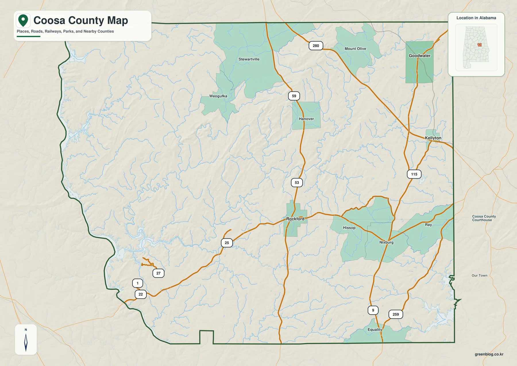
The general county map gives the broadest view of places and roads. Rockford appears close to the center, while Goodwater is near the northeastern corner. Kellyton lies farther south on the eastern side. Weogufka and Stewartville provide useful markers in the northwest, Hanover sits north of Rockford, and communities such as Hissop and Nixburg help define the east-central part of the county. Equality appears near the southern edge. These names are spread across a large area rather than packed into one continuous developed corridor, which is one of the first patterns the map reveals.
Roads help connect those scattered places. U.S. 280 crosses the northern part of the county near Goodwater, and several Alabama state routes meet or pass near Rockford before continuing toward the county line. Route numbers visible on the map include 9, 22, 25, 27, 53, 59, 115, and 259. The map is not intended to replace live navigation, but it is useful for learning which roads are associated with a town and for seeing whether a location is closer to the northern, central, eastern, or western side of the county.
For someone unfamiliar with Coosa County, it is often easier to begin with Rockford and Goodwater than to memorize every road number. Once those two places are fixed in mind, Weogufka can be placed in the northwest, Kellyton on the east side, and Equality near the southern boundary. That simple framework also makes the other thematic maps easier to read because the creeks, lakes, and ridges can be related back to known settlements.
Comparing Goodwater, Rockford, and Kellyton
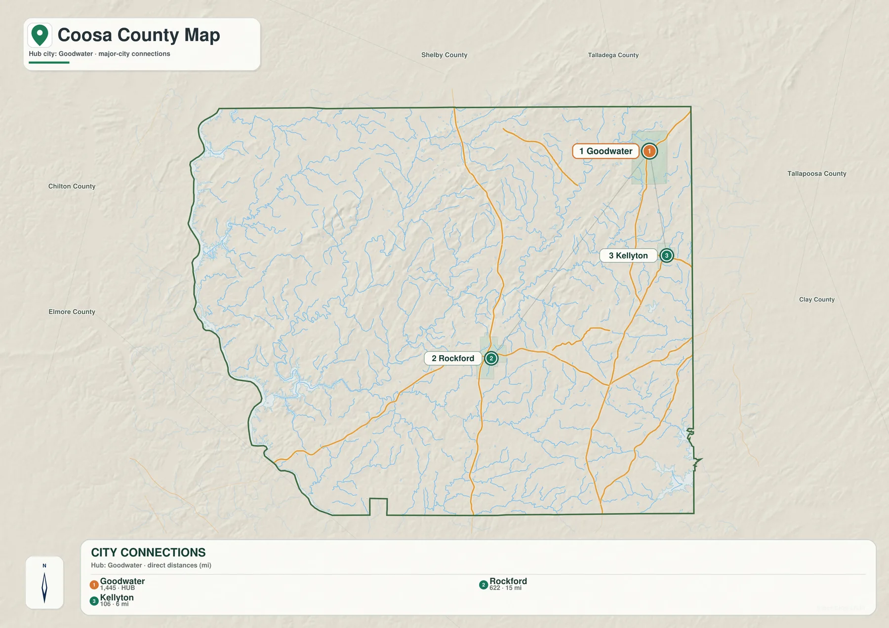
The city-connections map removes much of the smaller place detail and focuses on Goodwater, Rockford, and Kellyton. Goodwater is used as the hub. Rockford is labeled about 15 miles away, and Kellyton about 6 miles away. These values are straight-line distances between points, not driving distances measured along roads. They are best used for judging separation and direction, while actual travel planning should rely on a current road map or navigation service.
This simplified view makes the settlement pattern especially clear. Goodwater occupies the northeastern part of the county, Rockford is much closer to the center, and Kellyton is on the eastern side between those broad zones. The large areas without highlighted municipalities are just as informative as the markers themselves. They show how much of Coosa County consists of rural land, small unincorporated communities, forest, creeks, and local roads rather than a continuous urban strip.
Neighboring county names are also shown beyond the border. Shelby and Talladega are to the north, Tallapoosa and Clay lie to the east, and Elmore and Chilton are on the western side. This helps place local trips in a wider central-Alabama context. A point near the eastern side may be geographically closer to communities across the Tallapoosa or Clay County line than to the far western edge of Coosa County, even though all three Coosa municipalities remain useful internal reference points.
Lay Lake, Mitchell Lake, and Hatchet Creek
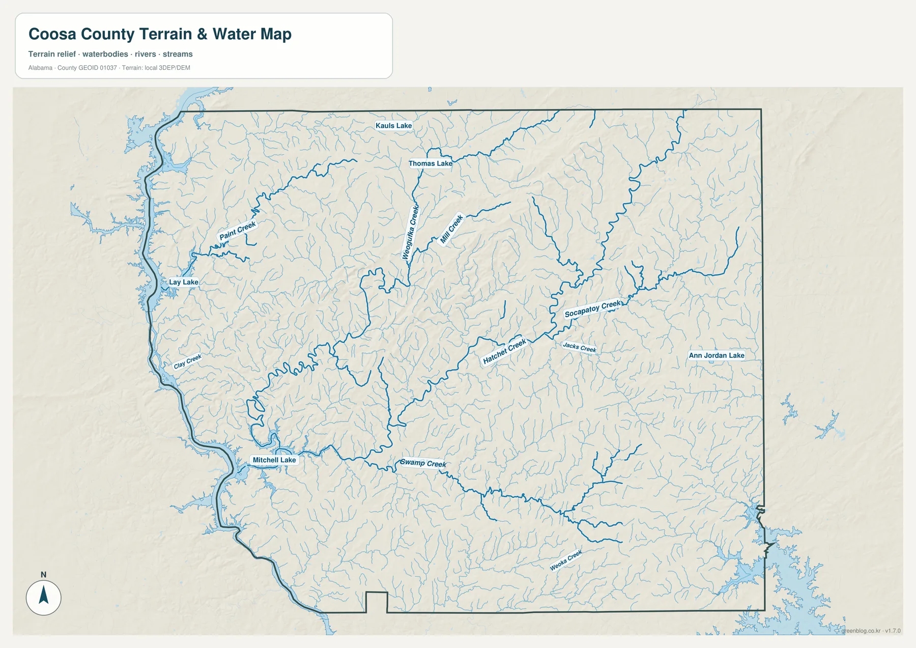
Water gives the western side of Coosa County a very different shape from the simpler boundary shown on the general map. Lay Lake touches the northwestern edge, and Mitchell Lake continues along the western side farther south. Their shorelines are narrow, branching, and irregular, with arms that extend into adjoining valleys. That makes the western border appear much more intricate once water is emphasized.
Hatchet Creek is the strongest named watercourse across the interior. It runs through the central and eastern part of the county and receives many smaller branches. Paint Creek and Weogufka Creek stand out in the northwest. Socapatoy Creek and Jacks Creek help define the eastern drainage network, while Weoka Creek appears in the southern part of the map. Mill Creek, Swamp Creek, Clay Creek, and numerous thinner unnamed tributaries reinforce the same point: Coosa County is cut by many small stream valleys rather than dominated by one broad flat basin.
The water map is useful for relating communities and roads to lakes and streams, but it is not a flood-zone product, a parcel map, or a navigation chart. It does not show current water levels or guarantee that every small water feature is suitable for access. For real-time conditions on Hatchet Creek or reservoir waters, official gauge and agency information should be checked separately. The value of this map is geographic context: it shows where the main waterways sit and how densely the county is divided by tributaries.
Lower western valleys and higher northeastern ridges
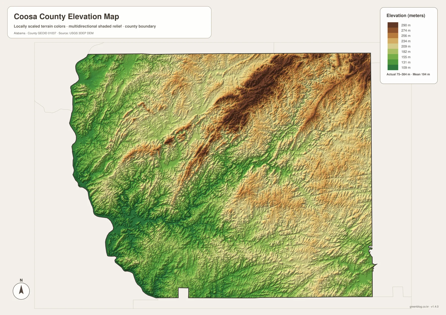
The elevation map changes the emphasis again. Instead of labels and road shields, it uses terrain color and shaded relief to show the shape of the land. Lower green areas are common near the western reservoir side and along several creek valleys. Moving into the county interior, the surface breaks into repeated narrow ridges and hollows. Stronger brown tones are especially visible toward the north-central and northeastern areas, making the contrast with the lower western side easy to recognize.
The legend uses local elevation colors, with labeled steps from roughly 109 meters to 290 meters. The map also notes a wider actual range of about 75 to 384 meters and a mean near 194 meters. Those figures are useful for county-wide comparison, but the image is still a generalized terrain surface. It should not be used as a survey-grade source for a construction site, property boundary, or exact building elevation.
What it does show very well is the relationship between valleys and ridges. The western lake margins sit in lower terrain. Farther east and north, long raised bands become more prominent, and the land looks increasingly broken by narrow drainage channels. Compare this view with the water map and many stream courses begin to make sense: creeks occupy lower corridors between the higher ground. That connection is one of the most useful reasons to keep the water and elevation maps separate but view them together.
Choosing the map that fits the task
For place names and road orientation, begin with the general county map. It has the most useful combination of settlements, road numbers, boundary lines, and surrounding context. If the goal is simply to compare the three incorporated municipalities, the city map is cleaner because it strips away much of the extra detail and makes the relative positions of Goodwater, Rockford, and Kellyton immediately visible.
The water map is the better choice when a project concerns lakes, creeks, outdoor geography, or the way drainage divides the county. The western reservoir shore and Hatchet Creek become the dominant features rather than secondary blue lines. The elevation map is most useful when the question is about hills, valleys, and broad terrain change. It does not tell you which road to drive, but it makes the lower lake side and higher ridge country easy to compare.
For school projects or presentations, pairing two maps often communicates more than using all four at once. The county map and elevation map work well together when explaining where towns sit in relation to the terrain. The county map and water map are a good combination for showing how Rockford, Weogufka, or Goodwater relate to creeks and reservoir edges. The city map is useful when a clean visual comparison is more important than small local place names.
The WebP images in the article are designed as quick browser previews. The downloadable archive contains four separate high-resolution JPG maps in A3 landscape format, giving more room for labels and terrain detail when printed or viewed on a larger screen. Because the themes are stored as separate files, you can use only the road map, water map, city map, or elevation map that fits the project instead of placing every detail on one crowded image.
Frequently Asked Questions
Are the distances on the city map driving distances?
No. The labels from Goodwater to Rockford and Kellyton are straight-line distances between the mapped points. Road mileage and travel time will be different because actual routes follow the road network, so current navigation data should be used for a trip.
Can the water map show flood risk?
No. It is a geographic reference map for lakes, creeks, and tributaries. It does not replace official flood-zone mapping, current stream gauges, reservoir notices, property surveys, or emergency information.
What files are included in the download?
The ZIP contains four high-resolution A3 JPG files: a general Coosa County map, a city-connections map, a water map, and an elevation map. They match the four map themes described on the page and are larger than the browser preview images.
Map File Information
Download the Coosa County map set as four high-resolution A3 JPG files in one ZIP archive.
- Included Files: County map, city map, water map, elevation map
- File Type: 4 high-resolution JPG files in one ZIP archive
- Intended Use: Printing, classrooms, presentations, and personal map reference
Related Maps
- Along the Cahaba Valley: Bibb County Alabama Map
- Between Two River Systems: A Clarke County Alabama Map
- Calhoun County Alabama Map
Sources and reference
- Coosa County Commission official information – local government reference for the county.
- ALDOT Coosa County functional-classification map – an official road reference for Coosa County.
- USGS Hatchet Creek near Rockford – station and water-data reference for Hatchet Creek.
- Alabama Forestry Commission: Weogufka State Forest – additional natural-area context for northwestern Coosa County.
These maps are intended for general geographic reference and comparison. When a project depends on a current road condition, legal boundary, water level, flood designation, or exact elevation, use the appropriate agency data or professional survey source in addition to the maps shown here.
Green Map creates custom-edited map images using open geographic data sources such as geoBoundaries, Natural Earth, OpenStreetMap, and government open data. These maps are edited visual materials, not raw data files, and are provided for education, documents, presentations, and graphic reference.