A Clay County Alabama Map is easiest to understand by starting with Ashland and Lineville and then looking toward the higher ridge country in the west and north. Ashland serves as the county seat, Lineville lies to the northeast, and smaller communities such as Delta, Millerville, and Hollins help define the wider county. Creeks occupy the lower valleys between long ridges, while the western landscape connects with the Talladega National Forest and the higher country near Cheaha. This page includes road, city, water, and elevation previews, plus a downloadable ZIP with high-resolution A3 JPG files for printing, classroom use, presentations, and offline reference.
The county does not have one dominant river or one large urban center. Its geography is defined more by small towns, forested ridges, numerous creeks, and short valleys. Once Ashland and Lineville are located, the roads, drainage network, and changing elevation become much easier to place within the county boundary.
Table of Contents
Ashland and Lineville provide the clearest road framework
Ashland sits slightly east of the county center, while Lineville lies farther northeast. Roads spread from these communities toward smaller places and the surrounding counties. Alabama 48 crosses the Lineville area, Route 130 runs through the central section between the two cities, Route 148 extends southwest from Ashland, and Route 49 provides a north–south reference through the southeastern part of the county.
Moving west and northwest, the road network enters more rugged and forested terrain. Delta, Millerville, and Hollins help identify the less urban parts of the county, while Talladega and Sylacauga outside the boundary provide additional regional context. The general map is therefore useful for understanding both settlement placement and the transition into the higher western landscape.
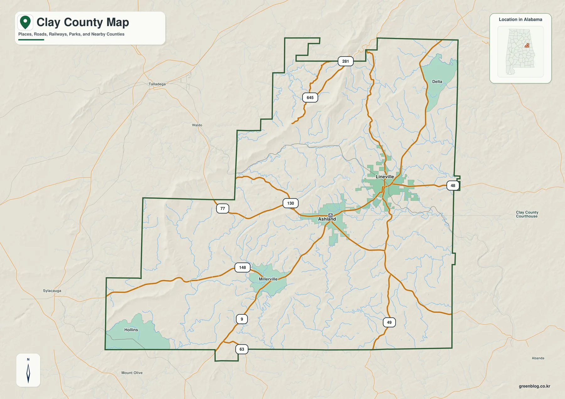
This overview is intended for regional orientation rather than detailed navigation. It can help identify where a community sits within the county and which main road passes nearby, but current driving directions and road conditions should be checked separately.
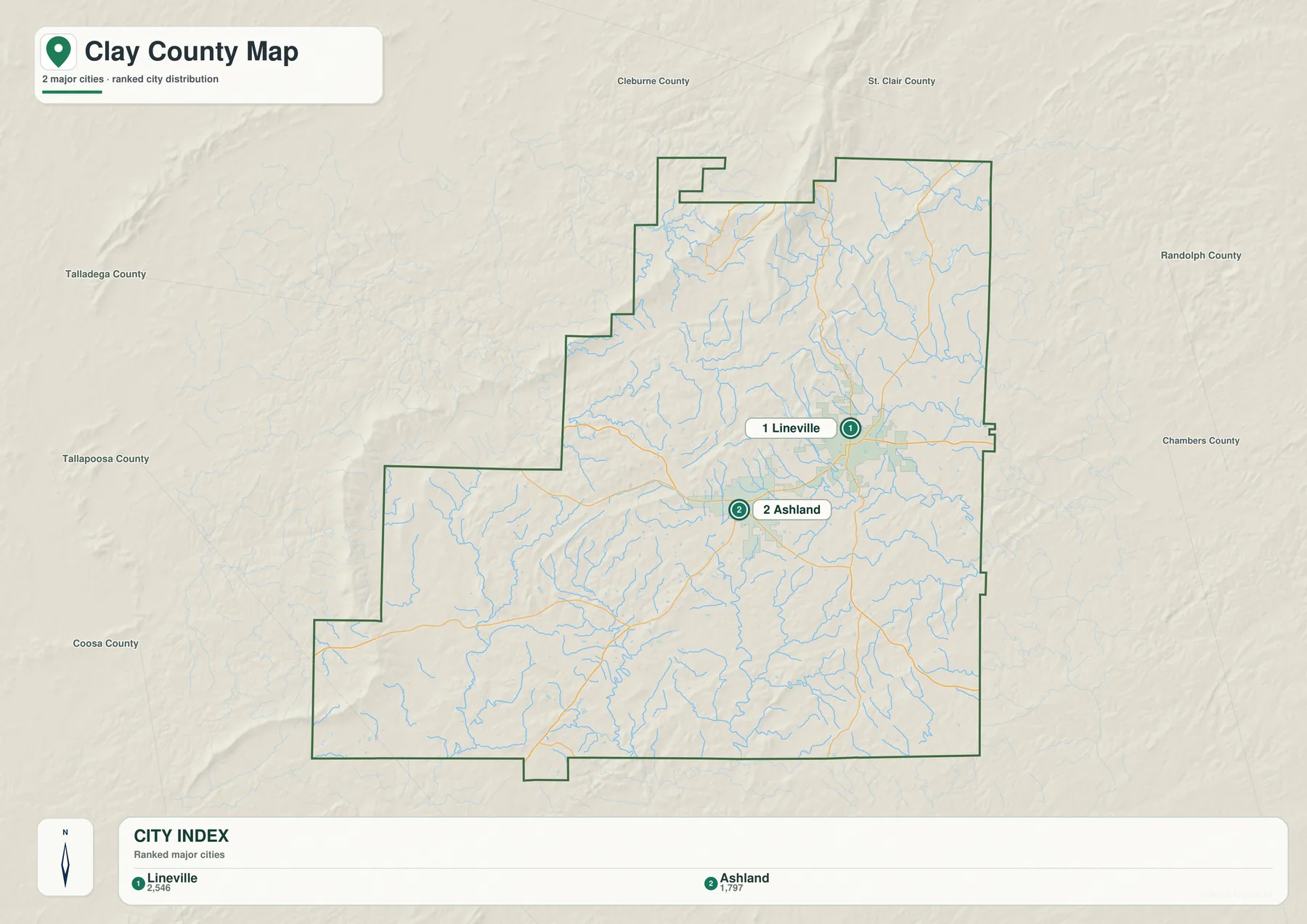
Ashland and Lineville form a simple eastern city pair
The city-focused view reduces background detail so the relative positions of Ashland and Lineville are easy to compare. Ashland is the southern and more central reference, while Lineville is positioned to the northeast. Together they show that the county’s two best-known cities are concentrated in the eastern half rather than spread evenly across the entire county.
Any connector line or distance label should be treated as a straight-line comparison rather than driving mileage. Roads through ridge-and-valley terrain can curve considerably, so actual travel may be longer than the direct distance suggests. For classrooms and presentations, however, the simplified view makes basic direction and spacing easy to explain.
Creeks divide the county into many small drainage valleys
Clay County is crossed by numerous small waterways rather than one dominant river. Talladega Creek is a major reference in the northwest, Shirley Mill Creek appears farther north in the interior, and Ketchepedrakee Creek and Fox Creek are visible toward the northeast. Hatchet Creek provides a southwestern reference, while Little Hillabee Creek runs through the southern part of the county.
Small lakes and ponds add more local landmarks. Lake Chinnabee lies in the north, Lake Gerald and Center Hill Lake are toward the northeast, and Lake David is farther east of center. Martins Lake and Blairs Lake appear in the south, while Newburys Pond provides another western reference. These features show that the county’s drainage is divided among many small valleys rather than concentrated in one broad river corridor.
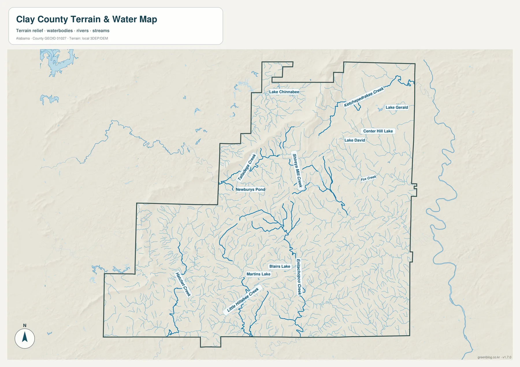
This water view is a geographic reference rather than a flood, navigation, or property product. It should not be used to determine flood risk, legal boundaries, water depth, or site-specific conditions; those questions require current official data.
Western and northern ridges rise above lower southeastern valleys
Elevation varies from roughly 173 to 710 meters across Clay County, with an average near 307 meters. The highest and most continuous ridge patterns appear along the western boundary and across parts of the north, while lower valleys become more common toward the east and south. Several long ridges also cross the interior at an angle, giving the county a more rugged appearance than a standard political map suggests.
The terrain is closely connected to the creek network. Water follows lower passages between ridges, which is why many streams curve through narrow valleys rather than crossing the county in straight lines. The proximity of Talladega National Forest and the highlands near Cheaha provides useful context for the stronger relief on the western side.
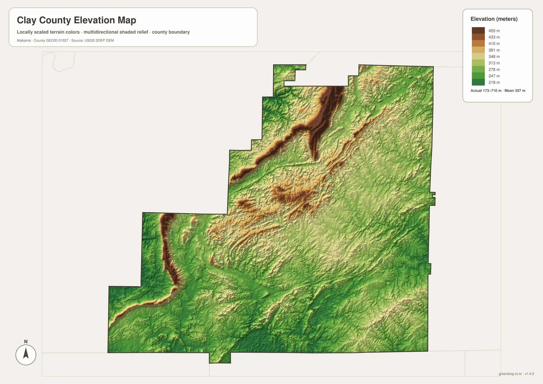
The elevation surface is intended for broad county-wide comparison. It helps show ridges, valleys, and relative height but should not be used as survey-grade information for a specific parcel, construction project, or engineering calculation.
Towns and natural areas make more sense when viewed together
Ashland works as the administrative and road reference, while Lineville provides a useful anchor for the northeastern part of the county. Moving west from these cities, development becomes less concentrated and forested ridge country becomes more prominent. Moving south or east, lower valleys and gentler terrain appear more often. This shift helps explain why roads, towns, and streams take different forms across a relatively small county.
The Talladega National Forest and the Cheaha highlands are especially useful for understanding the western landscape. Higher ridges extend through that side of the county, and small creeks occupy the lower passages between them. Comparing settlement locations with relief and drainage makes the region easier to understand than treating towns, water, and terrain as separate subjects.
Choose the view that matches the information you need
For basic orientation, start with Ashland, Lineville, the main roads, and the county boundary. Use the city-focused view when relative position matters more than road detail. The water layer is better for finding Talladega Creek, Hatchet Creek, and the smaller lakes, while the elevation layer provides the clearest explanation of the western ridges and lower southeastern terrain.
- Roads and places: locate Ashland, Lineville, smaller communities, and the main road corridors.
- Water: follow Talladega Creek, Hatchet Creek, smaller streams, lakes, and ponds.
- Terrain: compare the higher western and northern ridges with lower eastern and southern valleys.
- Natural setting: relate Talladega National Forest and the Cheaha highlands to the county’s ridge-and-creek landscape.
Keeping these subjects separate makes the files easier to use in classrooms, presentations, and printed handouts. A road-and-town discussion can remain uncluttered, while a physical-geography lesson can compare water and elevation directly. Each image stays readable, but the same county boundary makes it easy to connect the information.
Download the Clay County A3 JPG files
The ZIP below contains high-resolution JPG versions covering county roads and boundaries, city locations, waterways, and elevation. The WebP images in the article are intended for quick browser viewing, while the larger JPG files are better suited to printing, classroom handouts, posters, presentations, and other offline uses.
Frequently Asked Questions
Does the main map label every community in Clay County?
No. The map favors a small set of recognizable communities and major roads so the countywide view remains readable. For a denser transportation reference, the Alabama Department of Transportation county map is a better companion source.
Why compare the water and elevation maps?
The comparison shows how creeks occupy lower corridors between ridges. A winding channel that looks complicated on the water map often becomes easier to understand once the surrounding high ground is visible on the elevation sheet.
What is included in the downloadable ZIP?
The archive contains four high-resolution A3 landscape JPG files: the county overview, the two-city map, the terrain-and-water map, and the elevation map. The images embedded in the article are WebP previews rather than the download originals.
Map File Information
Download Clay County files for roads, communities, waterways, and terrain.
- Included Files: county map, city map, water map, elevation map
- File Type: high-resolution JPG files in one ZIP
- Intended Use: printing, education, presentations, and regional reference
Related Maps
- Along the Cahaba Valley: Bibb County Alabama Map
- Between Two River Systems: A Clarke County Alabama Map
- Calhoun County Alabama Map
- Alabama Population Density Map: Urban Clusters, County Totals and a Decade of Change
- Clay County Alabama Land Cover Map: 67.75% Forest Around Small Developed Clusters
Sources and further reading
- U.S. Census Bureau QuickFacts: Clay County, Alabama
- Alabama Department of Transportation Clay County map
- U.S. Forest Service Alabama Wilderness information
- USGS National Hydrography
- USGS 3D Elevation Program
- Encyclopedia of Alabama: Clay County
Green Map creates custom-edited map images using open geographic data sources such as geoBoundaries, Natural Earth, OpenStreetMap, and government open data. These maps are edited visual materials, not raw data files, and are provided for education, documents, presentations, and graphic reference.