A Miaoli County map is useful when you need more than a simple location view of northwestern Taiwan. Miaoli County sits between Hsinchu County to the north and Taichung City to the south, with the Taiwan Strait along its western side and more mountainous terrain toward the east. Because the county includes coastal towns, central urban areas, rural districts, and mountain communities, a labeled administrative map makes the regional structure much easier to understand.
This printable Miaoli County map collection includes three versions: a color map, a black and white map, and an outline map. The files are prepared as image files and designed for A3 printing, presentation slides, classroom handouts, blog graphics, regional comparison materials, and editable graphic projects. The color version helps separate the city and township areas visually, the black and white version works well for printed documents, and the outline version gives users a clean base for custom labels, coloring, routes, or data overlays.
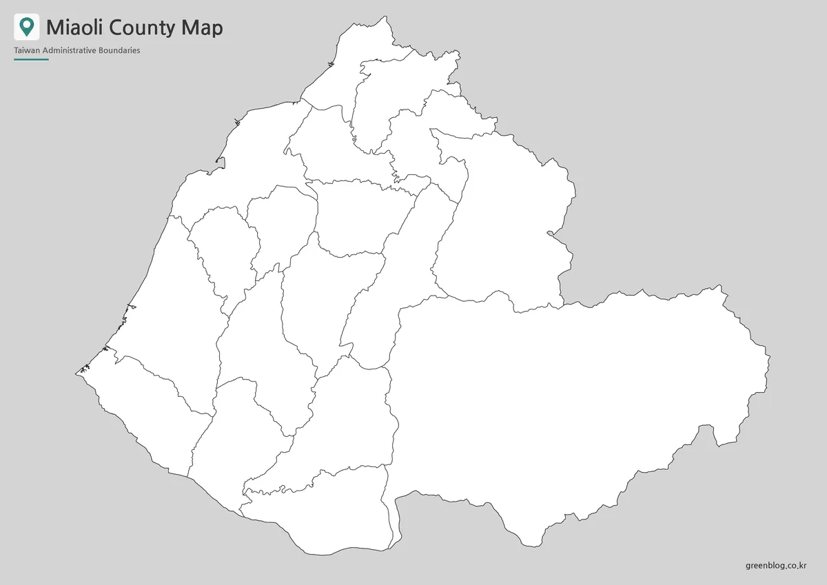
Miaoli County is divided into 2 cities, 5 urban townships, and 11 rural townships. Key places shown on the map include Miaoli City, Toufen City, Zhunan Township, Houlong Township, Tongxiao Township, Yuanli Township, Zhuolan Township, Dahu Township, Gongguan Township, Tongluo Township, Nanzhuang Township, Touwu Township, Sanyi Township, Xihu Township, Zaoqiao Township, Sanwan Township, Shitan Township, and Tai’an Township. This kind of internal boundary layout is especially helpful for students, teachers, map editors, and content creators who need to explain how different parts of the county connect.
While preparing the map layout, extra attention was given to the difference between the compact western areas and the wider eastern mountain-side districts. Labels in the western and central parts of the county can sit close together, while the eastern townships cover larger land areas. For that reason, the map was arranged to keep boundaries readable without making the design feel crowded.
Table of Contents
Miaoli County Map Overview
Miaoli County is located in western Taiwan, but its internal geography is not uniform. The western side connects to coastal areas, while the eastern side reaches into hill and mountain regions. This contrast matters when using the map for education, travel planning, or regional explanation because the county cannot be understood well from an outer border alone.
Zhunan and Toufen are located in the northern part of the county and often appear together in regional discussions. Miaoli City works as an important central reference point, while Tai’an Township occupies a much broader eastern area. When these places are viewed together on a labeled map, the administrative pattern becomes easier to compare.
For classroom use, the map can support Taiwan geography lessons, administrative boundary activities, and regional comparison worksheets. For bloggers and designers, it works as a visual reference when explaining places in northern or western Taiwan. Presentation creators can also use it to show where Miaoli County sits between Hsinchu and Taichung.
Included Map Files
The collection includes three practical map styles:
- Color administrative map
- Black and white printable map
- Blank outline map
Each version is designed for a different type of use. The color map is stronger for visual comparison, the black and white map is cleaner for handouts and reports, and the outline map is better when users need to add their own information.
Color Map for Administrative Comparison
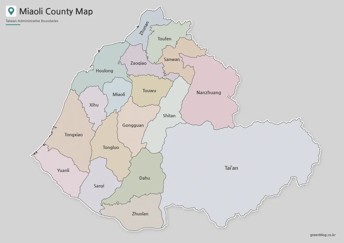
The color version separates Miaoli County’s cities and townships so the internal structure can be read quickly. This is especially helpful because the county has a mix of compact western administrative areas and larger eastern rural townships. Without color separation, the smaller areas near the coast and central region can be harder to follow.
For presentation slides, the color map gives viewers a faster way to distinguish places such as Zhunan, Toufen, Miaoli City, and Tai’an. It also works well in blog graphics or regional comparison materials where the reader needs to understand location relationships at a glance.
During preparation, the color balance was adjusted so neighboring areas would not blend together too easily. This matters for Miaoli County because several western and central districts sit close to one another, while the eastern side contains broader mountain-side areas.
Black and White Printable Version
The black and white Miaoli County map is designed for printed materials, worksheets, reports, and simple document layouts. Instead of relying on color, this version focuses on boundary clarity and label readability.
This format is helpful when the map is inserted into school materials, presentation notes, or reference documents where too much color may distract from the main information. It also works well for users who need a clean labeled map that prints clearly in grayscale.
Because Miaoli County includes several similar-sounding place names and many local divisions, label spacing was treated carefully. The goal was to keep the city and township names readable while maintaining a simple layout suitable for document use.
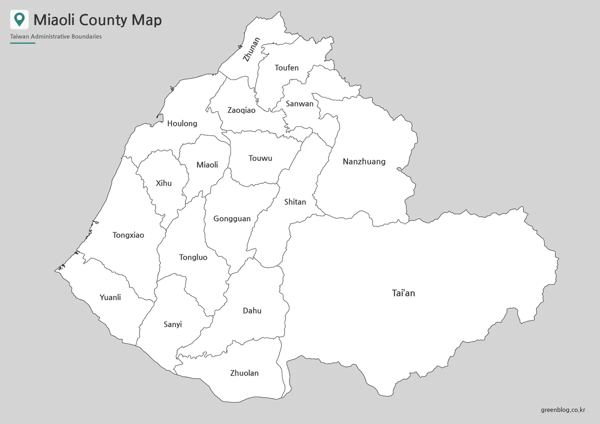
Blank Outline Map for Editing
The outline version provides the boundary structure without heavy visual styling. It works as a base map for users who want to add their own information, such as travel routes, highlighted districts, classroom coloring, population notes, project labels, or infographic annotations.
Teachers can use the blank Miaoli County outline map for geography activities or administrative boundary exercises. Designers can use it as a starting point for custom graphics, especially when creating regional comparison visuals or map-based presentation slides.
The outline map is also useful when only boundary lines are needed. Instead of removing labels or colors from a finished map, users can start with a cleaner version and build their own layout on top of it.
Administrative Areas Shown on the Map
The Miaoli County map includes the following administrative areas:
| Type | Administrative Area | Type | Administrative Area |
|---|---|---|---|
| City | Miaoli City | Rural Township | Gongguan Township |
| City | Toufen City | Rural Township | Tongluo Township |
| Urban Township | Zhunan Township | Rural Township | Nanzhuang Township |
| Urban Township | Houlong Township | Rural Township | Touwu Township |
| Urban Township | Tongxiao Township | Rural Township | Sanyi Township |
| Urban Township | Yuanli Township | Rural Township | Xihu Township |
| Urban Township | Zhuolan Township | Rural Township | Zaoqiao Township |
| Rural Township | Dahu Township | Rural Township | Sanwan Township |
| Rural Township | Shitan Township | Rural Township | Tai’an Township |
This structure makes the map useful for more than simple location identification. It can help users compare the county’s western coastal side, central administrative areas, and larger eastern rural townships in one view.
Practical Uses for the Miaoli County Map
A printable Miaoli County map can be used in many practical projects. Students may use it for Taiwan geography assignments, while teachers can include it in classroom handouts or regional worksheets. The labeled versions help explain administrative boundaries without requiring a separate atlas or online map view.
For content creators, the map works well in blog posts, video backgrounds, travel explanations, and regional comparison articles. It can also support infographic projects where different parts of Miaoli County need to be highlighted separately.
The outline version is especially useful when users need to add custom information. Routes, statistics, highlighted townships, tourism points, and local project notes can all be added more easily on a clean boundary map.
Frequently Asked Questions
What versions are included in this Miaoli County map collection?
The collection includes a color map, a black and white map, and an outline map. Each version is designed for a different use, from presentation graphics to classroom printing and editing work.
Can I use the Miaoli County map for A3 printing?
Yes. The map files are prepared with A3 printing in mind, making them suitable for larger classroom materials, posters, and presentation references.
Is the outline map good for editing?
Yes. The outline version is intended for editing, coloring, marking routes, adding labels, and creating custom infographic layouts.
Does the map show internal administrative boundaries?
Yes. The map includes Miaoli County’s city, township, and rural township boundaries, not just the outer county border.
Download Miaoli County Map
This download includes printable Miaoli County map versions for educational use, presentation design, document printing, and editable graphic projects.
- Included Versions: Color map, black and white map, outline map
- Printable Size: A3 layout
- File Type: Image files
- Intended Use: Classroom handouts, presentations, blog graphics, infographic editing, and printable reference materials
Additional Resources
- Miaoli County Government – Cities and Townships : A useful official reference for checking Miaoli County’s city and township structure when comparing the map with local administrative information.
Related Maps
- Hsinchu County Map – Printable Taiwan Administrative Map Collection
- Printable Yilan County Map with Administrative Boundaries
- Taichung City Map for Printing, Editing, and Classroom Use
- High Resolution Taoyuan City Map for Classroom and Presentation Use