A Korean version of this map page is available. View Korean Page
A Tainan City Map is useful when you need more than a simple location view of southern Taiwan. Tainan is located in southwestern Taiwan, with Chiayi County to the north, Kaohsiung City to the south and east, and the Taiwan Strait along its western side. Because the city includes a compact urban center, coastal districts, inland communities, and wider rural areas, a district-based map makes the regional layout much easier to understand.
This printable Tainan City map collection includes color, black and white, and outline versions designed for classroom reference, travel planning, blog graphics, presentation slides, and editable infographic projects. The maps are prepared as image files and arranged for A3-size printing, making them suitable for both digital use and printed materials. Whether you are comparing districts, marking travel routes, preparing a worksheet, or adding a clean map to a report, the three versions give you different levels of visual detail.
Tainan is divided into 37 districts. Central areas such as West Central, East, South, North, Anping, and Annan form the main urban section, while districts such as Qigu, Beimen, Jiangjun, Dongshan, Baihe, and Nanhua show how far the city extends toward the coast and inland mountain-side areas. This is why a labeled district map is especially helpful. Without a boundary map, Tainan can easily look like one continuous city, even though its districts have very different sizes, shapes, and local characteristics.
During the map preparation process, extra attention was given to district readability. Some urban districts are small and closely packed, while coastal and inland districts take up much larger areas. The layout was checked so that labels, boundary lines, and visual spacing remain clear when used in a large printed format or inserted into presentation slides.
Table of Contents
Tainan City Map Overview
Tainan’s administrative structure is one of the main reasons a Tainan City Map is useful for more than simple location checking. The city is not limited to the historic urban core. It stretches from dense central districts toward coastal wetlands, agricultural areas, and inland communities.
A simple Taiwan location map may show where Tainan is, but it does not explain how the city is divided internally. For school projects, travel planning, regional comparison, and map-based design work, district boundaries provide more useful context.
The collection includes three main styles:
- Color map for quick district recognition
- Black and white map for printing and document use
- Outline map for editing, coloring, and custom data marking
Each version is designed for a different type of project, so users can choose the map style that fits their purpose instead of relying on one general image.
Color-Coded District Map
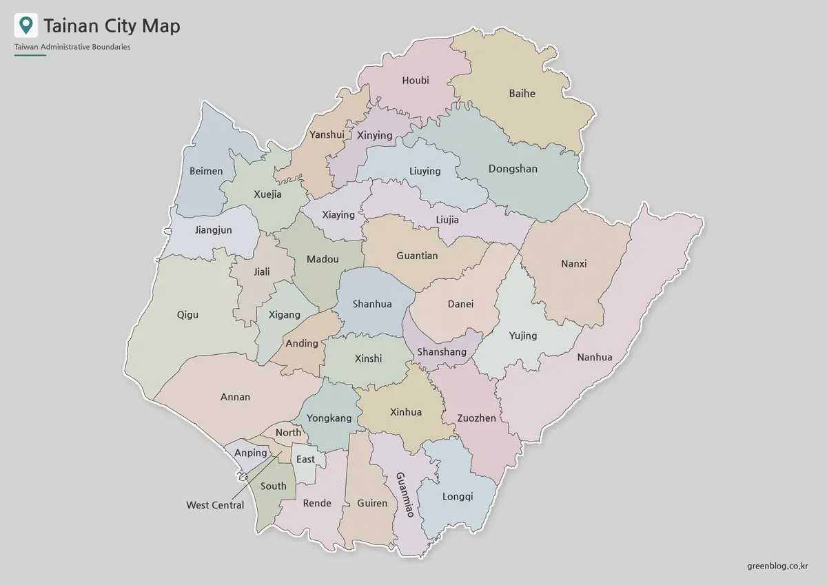
The color version is designed to make Tainan’s 37 districts easier to compare at a glance. This is especially helpful because the city includes both compact central districts and much larger outer districts. When all boundaries are shown in the same style, smaller urban areas can become harder to separate visually.
Color separation helps distinguish central districts such as West Central, East, North, South, and Anping from wider districts such as Qigu, Beimen, Dongshan, and Nanhua. This makes the map useful for travel presentations, regional overview graphics, classroom materials, and blog images about southern Taiwan.
The color version of the Tainan City Map works well when the goal is quick visual understanding. It is a good choice for explaining where major districts are located, comparing coastal and inland areas, or showing the relationship between Tainan’s historic center and its broader administrative area.
Black and White Printable Version
For reports, handouts, worksheets, and document layouts, the black and white version provides a cleaner visual style. It keeps the focus on district names and boundary lines without relying on color.
This version is especially helpful when the map needs to be printed in grayscale or placed inside a text-heavy document. Tainan has many district labels, and the simplified layout helps prevent the page from looking too crowded. Boundary lines were balanced so that the map remains readable without strong color contrast.
Teachers may use this version for geography lessons, students can place it inside assignments, and bloggers can use it as a neutral reference image. It also works well in travel documents where the map needs to support the text rather than dominate the page.
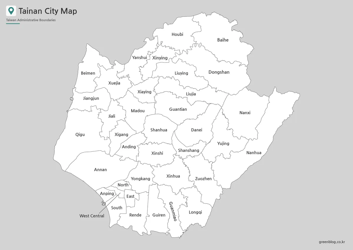
Blank Outline Map for Editing

The outline version of the Tainan City Map keeps only the district boundary structure, making it the most flexible map in the collection. It is intended as a working base map for users who want to add their own information.
You can mark travel routes between central Tainan and coastal districts, highlight specific districts, add tourism points, compare urban and rural areas, or create custom educational worksheets. Designers may also use it as a base for infographics, presentation highlights, or regional data visualization.
Because the outline map removes color and unnecessary visual elements, it is easier to edit in graphic design workflows. It is also useful for classroom coloring activities or simple district identification exercises.
Built for Printing, Teaching, and Visual Projects
This Tainan City Map collection was prepared for practical use rather than general viewing only. A3-size layout support makes the maps suitable for printed reference sheets, classroom handouts, and larger presentation visuals.
Tainan’s district layout also makes the map useful for travel-related content. The historic center, Anping area, coastal districts, and northern districts are not always close to one another, so a district map helps explain movement and regional distance more clearly.
For blog posts, the map can support articles about Tainan travel, Taiwan city comparisons, local district guides, and southern Taiwan geography. For presentations, the color map gives quick recognition, while the black and white map gives a cleaner look for formal slides.
Frequently Asked Questions
How many districts are shown on the Tainan City Map?
The map shows Tainan City’s 37 districts. This includes compact central districts, coastal districts, northern districts, and wider inland areas.
Which version is best for travel planning?
The color map is usually the easiest choice for travel planning because districts can be compared quickly. It works well when explaining the difference between central Tainan, Anping, coastal areas, and outer districts.
Can I use the black and white map for printing?
Yes. The black and white version is designed for clean document printing, classroom handouts, worksheets, and report layouts.
What is the outline map best for?
The outline map is best for editing, coloring, labeling, and adding custom information. It can be used for infographic projects, teaching materials, route marking, or district comparison work.
Is this map useful for classroom projects?
Yes. The collection is suitable for geography lessons, Taiwan city comparison materials, printable worksheets, and student assignments.
Map File Information
This download includes printable Tainan City map versions for educational use, presentation design, document printing, and editable graphic projects.
- Included Versions: Color map, black and white map, outline map
- Printable Size: A3 layout
- File Type: Image files
- Intended Use: Classroom handouts, presentations, blog graphics, infographic editing, and printable reference materials
Additional Resources
- Tainan City Administrative District Map : A useful official reference for checking Tainan City’s district boundaries and administrative layout.
Related Maps
- Taichung City Map for Printing, Editing, and Classroom Use
- High Resolution Taoyuan City Map for Classroom and Presentation Use
- New Taipei City Map Download with District Boundarie
Green Map creates custom-edited map images using open geographic data sources such as geoBoundaries, Natural Earth, OpenStreetMap, and government open data.
These maps are edited visual materials, not raw data files, and are provided for education, documents, presentations, and graphic reference.