A Taichung City Map must fit one exceptionally large eastern district and a dense western cluster onto the same page. Heping occupies most of the long right-hand side, while many smaller districts gather near the coast and urban center. The supplied landscape layout preserves all 29 boundaries and solves the tightest labeling problem by representing five central districts with numbers linked to a small legend.
The Taichung City Map set provides three matching administrative views: a pastel color map, a labeled black-and-white map, and an unlabeled outline. Each published preview measures 1,200 × 698 pixels and uses the same municipal geometry. The protected package supplies the versions in JPG format for A3-oriented use, while the page previews included for review are WebP images.
Twenty-four districts are written directly on the color and monochrome maps. South, West, North, East, and Central are instead marked as 1 through 5 because their shapes are too compact for five full labels at this scale. The legend disappears from the outline version along with every district name, leaving the complete boundary network available for recall work or custom annotation.
The images do not label the Taiwan Strait, neighboring counties, highways, railways, rivers, ports, attractions, elevation, or population. Although Taichung reaches Taiwan’s west coast and Heping is associated with the mountainous east, those geographic facts are not encoded as map layers here. Readers should treat the files as district references rather than navigation, tourism, transport, or physical maps.
Table of Contents
Taichung City Map Overview
Taichung is a special municipality in central-western Taiwan with 29 administrative districts. Its municipal silhouette stretches from a short, irregular western coastline far into the east. The gray exterior in these images supplies negative space only; no surrounding jurisdiction is named or divided.
The northern and northwestern sequence begins with Daan and Dajia, followed inland by Waipu and Houli. Qingshui, Wuqi, Shalu, and Longjing occupy the western side, with Dadu farther south. A small inlet-like cut near Wuqi is visible in the boundary, but no harbor, water name, or facility marker explains it.
Shengang, Fengyuan, Shigang, Tanzi, Daya, and Beitun form a closely connected band between the coastal group and the eastern side. Dongshi and Xinshe continue the transition toward Heping. On this Taichung City Map, Heping’s scale is immediately apparent because its single shape spans more horizontal space than the entire compact central group.
Xitun, Nantun, and Dadu sit west of the numbered center, while Beitun and Taiping frame it from the north and east. Dali, Wuri, and Wufeng extend across the south. These labels help readers reconstruct the urban core without assuming that visual size represents population, importance, or development.
The numbered inset is a map-reading feature rather than an extra administrative level. Number 1 means South, 2 means West, 3 means North, 4 means East, and 5 means Central. Anyone preparing a worksheet should retain the legend with the labeled maps; cropping it away would leave five unexplained numbers at the center.
Several Romanized labels deserve careful transcription. The artwork uses Daan, Wuqi, Qingshui, Shengang, Shigang, Xinshe, and Wufeng without adding “District” inside each boundary. Short forms reduce crowding, while captions and prose can use the full names, such as Daan District or Xinshe District, when grammatical context requires them.
Color District Map for Visual Comparison
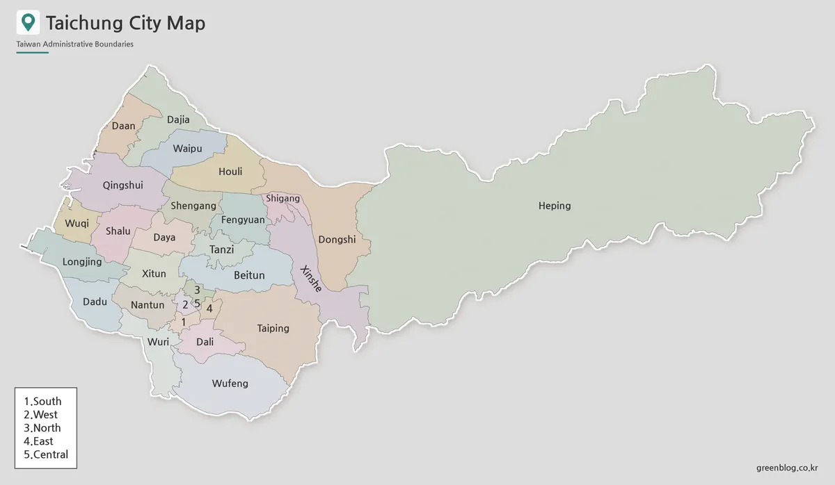
Pastel fills make neighboring districts easier to separate without implying a statistical scale. The treatment is particularly effective around Fengyuan, Tanzi, Beitun, Xitun, Nantun, Dali, and the five numbered center districts, where multiple boundaries meet within limited space. Heping receives a single pale fill across the broad eastern extension.
The color Taichung City Map is the clearest first reference for a lesson, answer key, or introductory presentation. Viewers can follow the coastal sequence, locate the districts surrounding the numbered center, and compare the western cluster with Heping at a glance. The color categories are decorative separators only and do not encode land use, elevation, transport access, demographics, or tourism zones.
The white outer stroke makes the municipality stand apart from the gray background, and the light drop shadow adds visual depth. Those effects should not be interpreted as a second boundary or offshore area. If a project adds data colors, replace the original palette or supply a new legend so readers can distinguish the added meaning from the base design.
Black and White Printable Version
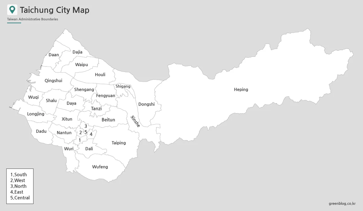
The black-and-white Taichung City Map retains the 24 written names, five numbered markers, legend, municipal outline, and internal boundaries while removing all district fills. This keeps the page restrained when it appears beside text or tables. Learners can add their own highlights without competing with a preset palette.
Line geometry becomes the main cue in monochrome. Heping remains unmistakable through its extent, Daan and Dajia form the narrow northwestern tip, and the compact center still depends on the 1–5 key. The version therefore suits guided identification better than a test requiring unaided recall.
Print one test page before producing a classroom set. Heavy reduction may make the central boundaries, their numbers, and the tiny Shigang label difficult to distinguish; aggressive cropping can remove the legend at the lower left. Preserve the 1,200 × 698 aspect ratio so the coast-to-Heping silhouette is not stretched vertically or compressed horizontally.
Blank Outline Map for Editing
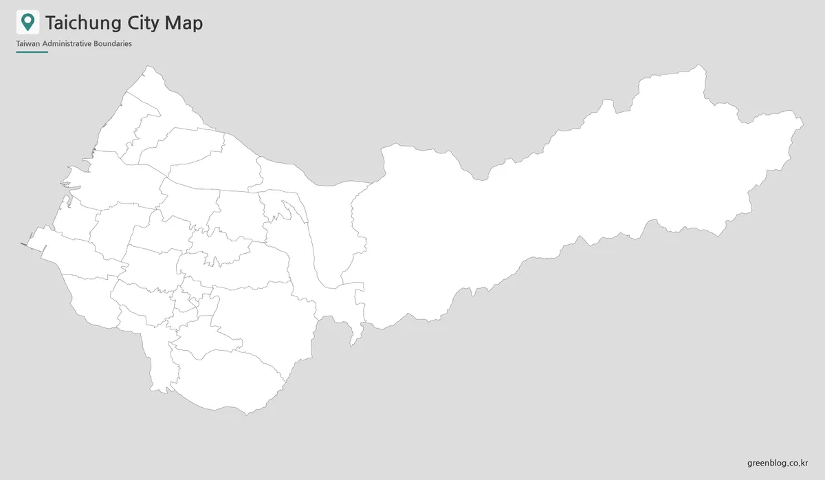
The outline removes every district name, all five central numbers, the legend, and the pastel colors while preserving the 29-unit geometry. The title and “Taiwan Administrative Boundaries” subtitle remain at the top. It is therefore an unlabeled district outline, not a fully empty image or an editable vector source.
A blank Taichung City Map supports several location-specific tasks. Students can label the coastal chain from Daan to Dadu, rebuild the Fengyuan-area cluster, identify the five central districts from boundary shape, or shade Heping only after locating its western neighbors. Pairing the outline with the monochrome map creates a straightforward exercise-and-answer-key set.
Designers can overlay a custom category or one carefully sourced statistic per district, but every added symbol and color needs a legend. Routes, stations, rivers, elevations, ports, and attractions require coordinates or a dedicated source; they should not be estimated from these boundaries. The supplied image is raster, so “editing” means drawing or placing information over the map rather than manipulating vector paths.
Designed for Classroom, Blog, and Presentation Use
A classroom sequence can move from visual separation to independent recall. Begin with color to establish the western cluster and Heping extension, continue with monochrome for guided labeling, and finish with the outline. The five-number solution itself can become a cartography discussion about how limited space changes label design.
For editorial graphics, color provides the quickest district comparison, monochrome blends more quietly into a report, and outline accepts a single project-specific data layer. A Taichung City Map also prevents “Taichung” from being reduced to only the compact downtown: the complete municipality includes coastal districts, former county areas, and the long eastern territory of Heping.
Choose the labeled versions whenever direct reference matters, and use the outline when readers must supply names or categories. Keep the numbered legend whenever numbers remain visible. For navigation, travel planning, or current infrastructure, supplement the administrative image with an authoritative transport or local map designed for those decisions.
Frequently Asked Questions
What is included in this Taichung City Map collection?
The collection includes a color district map, a black and white map, and a blank outline map of Taichung City.
Is this Taichung City Map suitable for A3 printing?
Yes. The map was prepared for A3-size printing, making it suitable for larger classroom handouts, presentation boards, and printed reference sheets.
What file format is included?
The map files are provided in JPG format.
Should every label include “District” on the map?
Not necessarily. Since Taichung has 29 districts, shorter labels such as Xitun, Beitun, Fengyuan, and Heping are easier to read inside the map. The full district names can be used in captions or article text.
Is the outline version editable?
Yes. The blank outline map is useful for adding colors, labels, markers, travel routes, data points, or custom infographic elements.
Map File Information
The protected package contains three matching views for 29-district reference, monochrome printing, recall practice, and custom annotation.
- Included Versions: Color map · Black and white map · Outline map
- File Type: JPG map files
Related Maps
Additional Resources
- Taichung City Districts and Landmarks — The official city page lists all 29 districts and introduces landmarks associated with different parts of Taichung.
Green Map creates custom-edited map images using open geographic data sources such as geoBoundaries, Natural Earth, OpenStreetMap, and government open data.
These maps are edited visual materials, not raw data files, and are provided for education, documents, presentations, and graphic reference.