A Louisiana Parish Map has to fit 64 county-equivalent areas into a state outline that changes dramatically from the straight northern border to the fragmented southeastern coast. The supplied set uses three matching views—a pastel color reference, a labeled black-and-white map, and an unlabeled outline—so readers can move from identification to printing and then to their own labeling work.
Louisiana is the only U.S. state that calls these primary county-equivalent divisions parishes. The official state directory lists all 64, and the artwork places every parish name inside its corresponding shape on both labeled versions. That makes the collection suitable for classroom geography, statewide reference sheets, presentation graphics, regional comparisons, and custom data illustrations.
The three WebP page previews share the same parish geometry. The color preview measures 1,200 × 1,104 pixels, while the monochrome and outline previews are 1,200 × 1,105 pixels. The protected download is a ZIP archive described as containing JPG files prepared for A3 printing; use those downloadable files rather than enlarging the smaller WebP previews for a final print layout.
The Louisiana Parish Map does not plot cities, roads, highways, rivers, population values, or elevation. Names such as East Baton Rouge, Orleans, Lafayette, Caddo, and St. Tammany identify parishes here, not separate city markers. The lower blue area suggests coastal water in the color version, but neither the Gulf of Mexico nor individual bays and waterways are labeled.
Table of Contents
How to Read a Louisiana Parish Map
The northern half is comparatively broad and rectangular. Caddo and Bossier occupy the northwest, with Webster, Claiborne, Lincoln, Union, Morehouse, West Carroll, and East Carroll extending across the upper tier. Many boundaries in this area contain long straight segments, making the parishes easier to distinguish even before color is added.
Moving south through the interior, the pattern becomes more varied. Natchitoches, Winn, Grant, Rapides, Avoyelles, Catahoula, and Concordia form a central transition between the wider northern blocks and the denser southern arrangement. Along the eastern edge, the outlines of East Carroll, Madison, Tensas, and Concordia follow an irregular state boundary rather than a single straight line.
Label density increases sharply around the Baton Rouge area. West Feliciana, East Feliciana, Pointe Coupee, West Baton Rouge, East Baton Rouge, Iberville, Ascension, Livingston, and St. Helena occupy a compact cluster where horizontal labels would not all fit. The artwork therefore rotates or stacks several names, a practical decision that keeps small parish shapes readable without using callout lines.
The southeastern coast creates the most distinctive shapes. Orleans, Jefferson, St. Bernard, Plaquemines, St. Charles, St. John the Baptist, Lafourche, and Terrebonne combine narrow connections, long projections, and broken coastal edges. Cameron, Vermilion, Iberia, and St. Mary continue the irregular shoreline toward the southwest. These forms make Louisiana’s parish framework visibly different from a grid-based state map.
Some names in the artwork use compact styling, including “St.Tammany,” “St.Landry,” and “St.John the Baptist,” while DeSoto and LaSalle appear with simplified capitalization. When copying labels into a report, consult the official Louisiana directory for standard spacing and capitalization. The map remains useful for shape recognition, but its design text should not replace an authoritative name list.
Included Map Versions
Every version contains the outer state silhouette and 64 internal parish boundaries. The color and monochrome maps include all parish labels, while the outline removes the names. None includes separate city symbols, neighboring-state names, a scale bar, or a data legend.
Because the geometry is consistent, the three maps can function as a sequence rather than unrelated illustrations. Readers may first study color separation, use the labeled monochrome view as a compact answer key, and finish with the blank outline for recall, custom grouping, or sourced thematic information.
Regional Color Map
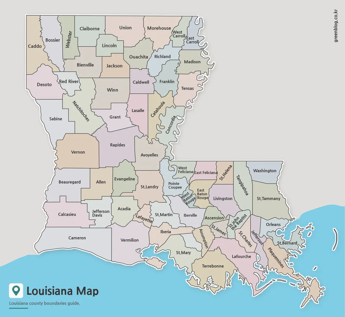
The color map assigns contrasting muted fills to adjacent parishes. That separation is especially valuable where multiple small areas meet around Baton Rouge and where the lower Mississippi and coastal portions create narrow or irregular shapes. Color helps the eye continue a boundary that might otherwise disappear among closely packed labels.
Use the color Louisiana Parish Map as an introductory reference, presentation slide, or answer key. The pastel fills are categorical only: they do not represent political affiliation, population, land cover, flood risk, or another measured variable. If the image is adapted for statistics, replace or clearly explain the original colors with a new legend.
The blue coastal background makes southern projections and islands easier to see, while the gray exterior isolates the land boundary elsewhere. However, the water area has no geographic labels, and surrounding states are not named. A separate regional map is needed when the task depends on Texas, Arkansas, Mississippi, or Gulf Coast context.
Labeled Printable Version
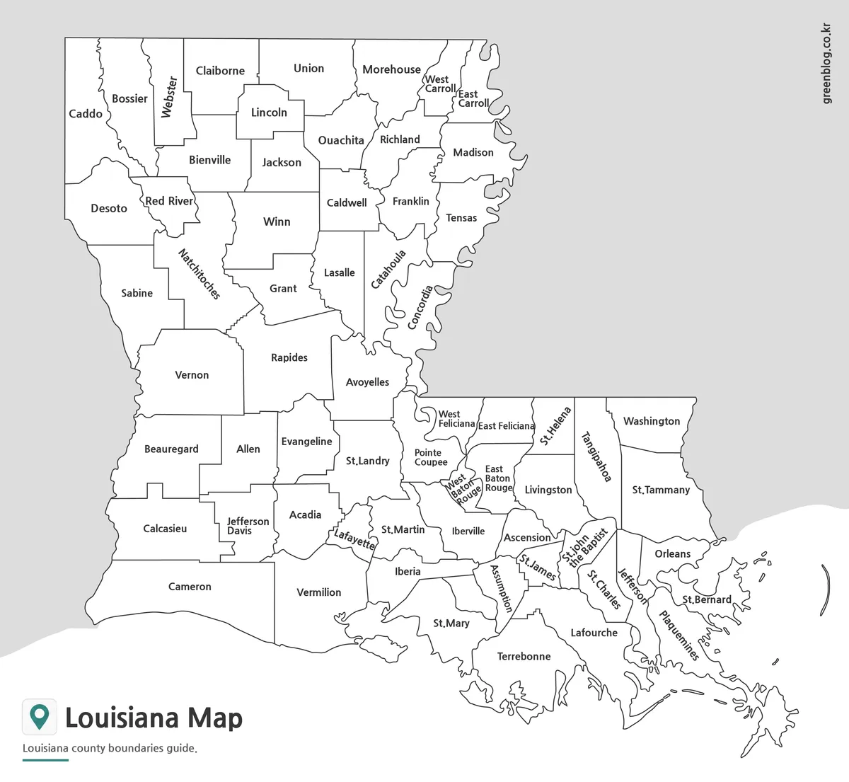
The labeled black-and-white Louisiana Parish Map preserves the full name set and boundary network without relying on color. It is the most direct choice for reports, handouts, or study sheets in which every parish must remain identifiable. The simpler treatment also reduces competition with surrounding text and charts.
Monochrome does not make this a blank activity: the labels remain the answers. Students can compare East and West Carroll, East and West Feliciana, or East and West Baton Rouge; trace the long shape of Plaquemines; and locate Orleans among neighboring southeastern parishes. The outline version is better when recall should be unaided.
At smaller print sizes, inspect West Baton Rouge, Lafayette, St. John the Baptist, St. James, and St. Charles before producing multiple copies. Their labels occupy limited space or use rotation. Preserve the original aspect ratio, and avoid cropping the southeast where coastal fragments extend close to the page edge.
Blank Outline Map for Editing
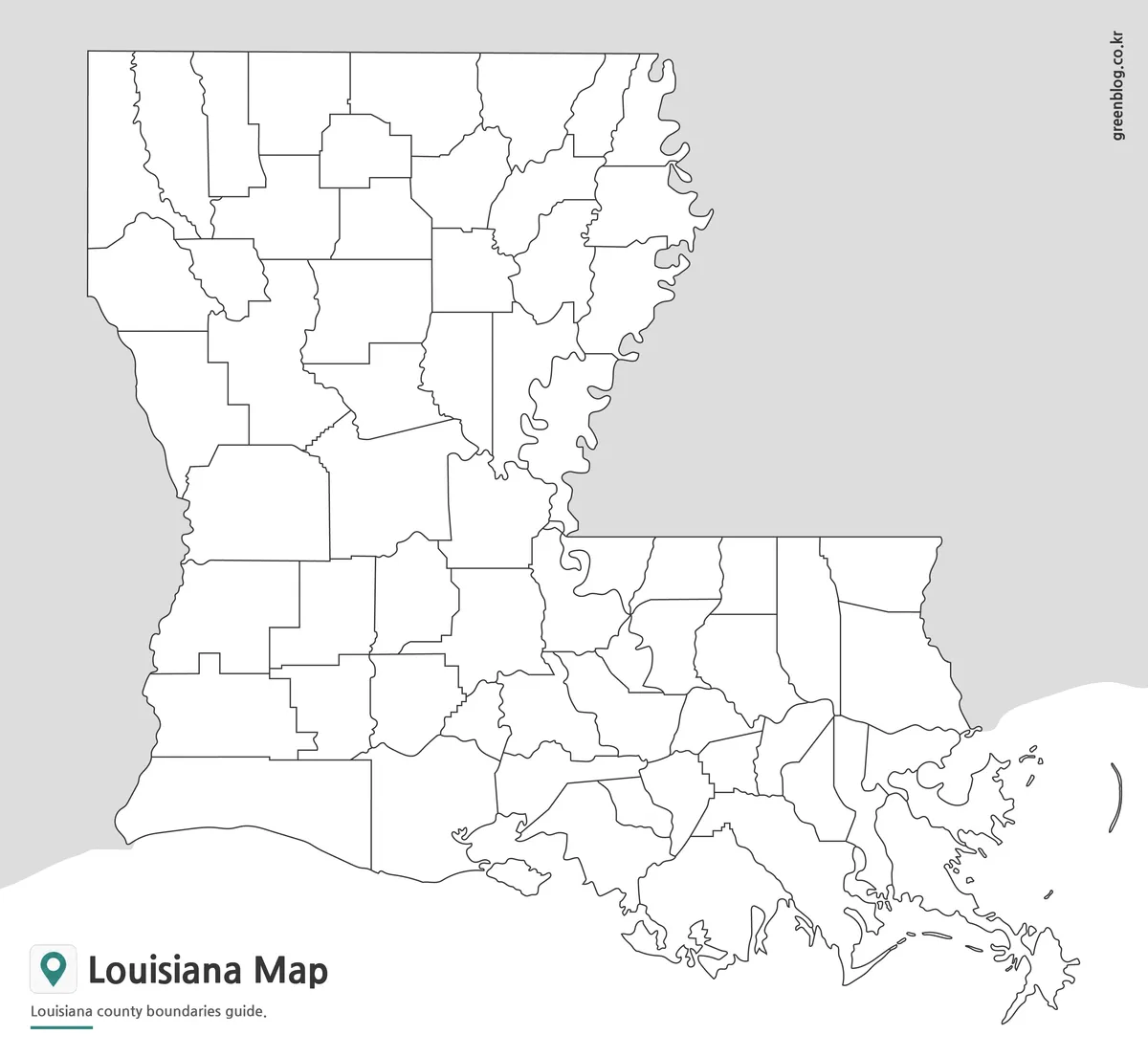
The outline Louisiana Parish Map removes all parish names and pastel fills while retaining the same 64 boundary shapes. Teachers can ask learners to identify the northern tier, label the Baton Rouge cluster, or reconstruct the coastal parishes. The matching labeled versions provide an answer key without changing the geometry.
For a custom project, users may add parish names, city points, routes, categories, or data values from a cited source. Each addition needs its own legend because the base contains no thematic meaning. The outline is a raster image preview and should not be described as an SVG, layered vector, or boundary dataset.
The most effective exercises use Louisiana-specific structure. Examples include coloring the nine “Saint” parishes as a name-recognition group, locating the three directional pairs that use East or West, or distinguishing Orleans Parish from the surrounding Jefferson, St. Bernard, and Plaquemines shapes. Such tasks turn the blank map into more than a generic coloring page.
Designed for Practical Use
Select color when fast separation matters, monochrome when labels must remain visible in a restrained document, and outline when readers will add information. A Louisiana Parish Map can support a three-step lesson: recognize shapes with color, review names in monochrome, and test recall on the blank version.
Presentation designers can focus on one part of the state by highlighting selected parishes, but the source map should remain visible enough to preserve statewide context. For example, a southeast inset may improve readability around Orleans and St. Bernard, while a northwestern crop can emphasize Caddo, Bossier, Webster, and Claiborne. Added crops should not be presented as separate administrative maps.
The set is not a city map. Baton Rouge, New Orleans, Shreveport, Lafayette, and other municipalities are not marked as point locations, even when a city shares a name with a parish. It is also unsuitable for navigation, road planning, flood analysis, or measuring distances because those layers and tools are absent.
For printing, place the downloaded JPG on an A3 page without distorting its proportions and check the smallest labels in a test copy. For digital work, retain enough resolution for thin coastal boundaries and compact interior names. Any new colors, symbols, or labels should be documented so readers can separate the original parish framework from the added information.
Frequently Asked Questions
What makes a Louisiana Parish Map different from maps in other states?
Louisiana uses parishes instead of counties, making its administrative structure unique within the United States.
Can I print the Louisiana Parish Map in A3 size?
Yes. The maps were prepared in high resolution and are suitable for large-format printing.
Which version is best for presentations?
The color map is usually the easiest option for visual presentations and regional comparisons.
Is the outline map editable?
Yes. The outline version is designed for annotation, custom coloring, and graphic editing projects.
Does the Louisiana Parish Map include parish boundaries?
Yes. All versions include Louisiana parish boundary information.
Map File Information
The protected archive contains three matching 64-parish maps for labeled reference, monochrome printing, and blank annotation work.
- Included Versions: Color map · Labeled black-and-white map · Blank outline map
- Printable Size: A3 layout
- File Type: JPG map files in a ZIP archive
- Intended Use: Lessons · reports · presentations · parish-labeling activities
Related Maps
Additional Resources
- Louisiana.gov Parish Directory — The official state directory lists all 64 parishes with links to local information and standard parish names.
Green Map creates custom-edited map images using open geographic data sources such as geoBoundaries, Natural Earth, OpenStreetMap, and government open data.
These maps are edited visual materials, not raw data files, and are provided for education, documents, presentations, and graphic reference.