Wheeler County lies along the eastern side of Nebraska’s Sandhills, where Bartlett and Ericson serve as the two principal village references in a broad landscape of ranch country, creek valleys, and grass-covered dunes. This Wheeler County Nebraska Map page combines the U.S. 281 corridor near Bartlett with Nebraska 70 and 91 near Ericson, plus Beaver Creek, the Cedar River system, and an elevation view that shows higher western and southwestern hills descending toward lower northeastern terrain. The WebP images are designed for quick viewing, while the same four maps can be downloaded below as high-resolution JPG files in one ZIP archive. High-resolution map files are available for download in the section below.
The county is easier to understand by starting with its two incorporated villages rather than looking for a dense city network. Bartlett is the county seat and the first-ranked community on the city panel, while Ericson lies well to the southwest near the Cedar River. The general map also labels Wheeler (historical) and Koinzan Ranch, reminders that much of the county between the villages consists of sparsely settled ranch and agricultural land rather than blank space.
Table of Contents
Bartlett and Ericson as the two anchors of Wheeler County
Bartlett sits south of the county center near U.S. 281, the clearest north-south route on the general map. Ericson lies in the southwest where Nebraska 91 approaches from the west and Nebraska 70 continues through the local road network. Those routes provide a simple framework for a county whose remaining roads are widely spaced and often identified by local route numbers rather than by major highways.
North and east of Bartlett, settlement labels become sparse and local roads cross broad ranch country. Wheeler (historical) appears northwest of the county center, while Koinzan Ranch is labeled in the east-central interior. These points are useful because they show how much of the map is organized around rural landmarks, ranches, and waterways rather than incorporated towns.
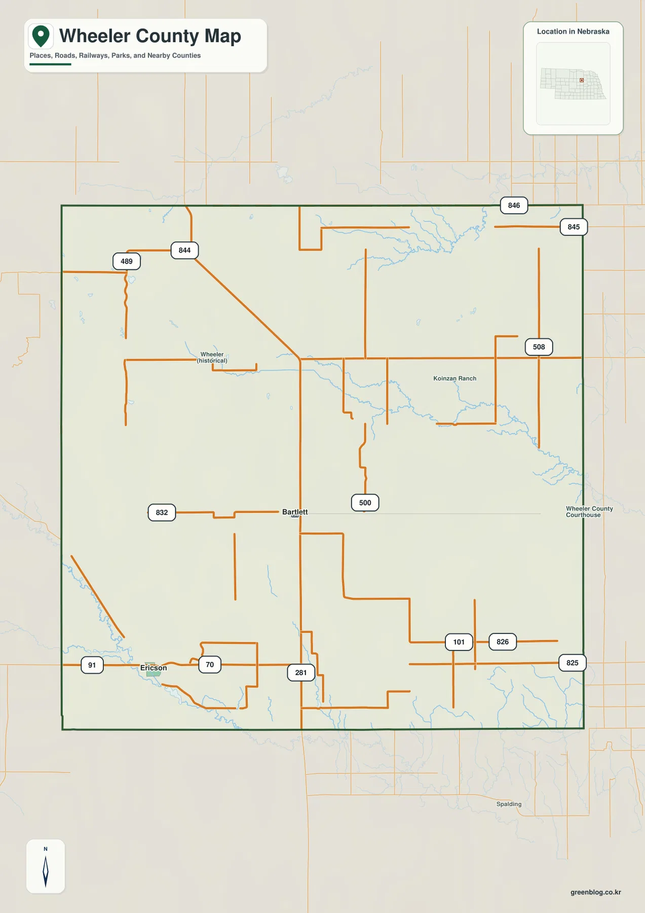
U.S. 281 provides the strongest route near Bartlett and continues south out of the county. Ericson has a different setting, close to the Cedar River and the highways approaching from Valley County. Between the two villages, local roads cross a surface shaped by Sandhills ridges and shallow valleys rather than a continuous street grid. Comparing this road image with the terrain maps makes that difference much easier to see.
This is a regional reference rather than a live navigation product. Construction, detours, and weather-related road conditions can change after a static map is produced. Its main value is orientation: readers can quickly locate Bartlett and Ericson, identify the county boundary, and understand how U.S. 281 and the Nebraska 70–91 corridor organize travel across a very lightly settled landscape.
A two-community city panel with no invented distance lines
The ranked city graphic is unusually simple. Bartlett is listed first and Ericson second, and there are no other major city markers. Bartlett appears in the south-central interior, while Ericson sits close to the southwestern boundary. The panel therefore works best as a settlement-distribution view rather than as a city-to-city route diagram.
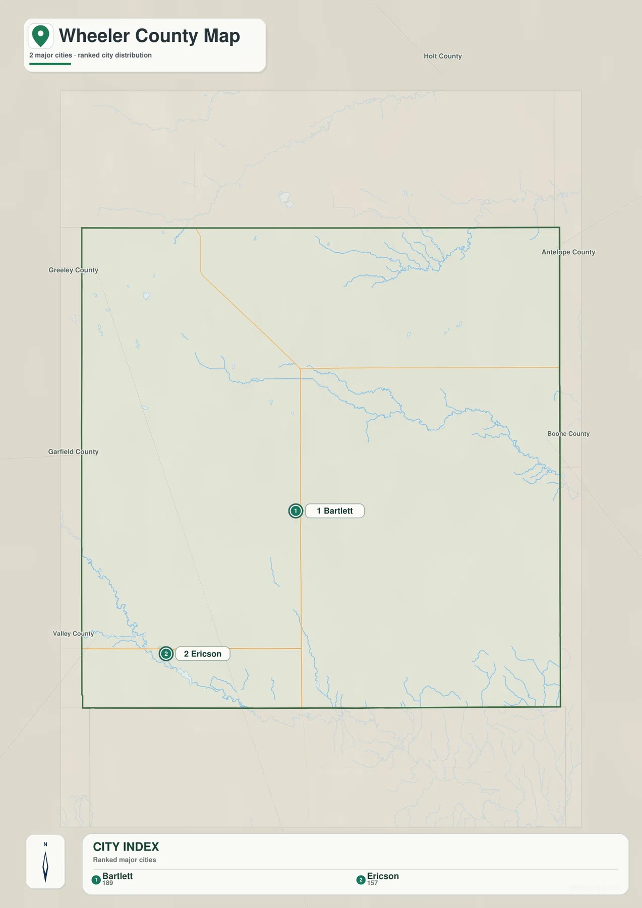
Unlike some county city maps, this one does not display a mileage label between the two villages. For that reason, no straight-line or driving distance should be inferred from the graphic itself. Anyone who needs travel mileage or driving time should use current route data based on the roads actually available between Bartlett and Ericson.
The official Wheeler County website also identifies Bartlett and Ericson as the county’s two villages. Bartlett functions as the administrative center, while Ericson provides a southwestern community reference near the Cedar River. With so few urban labels, the water and elevation maps become especially important for understanding the large area between them.
Beaver Creek across the center and the Cedar River near Ericson
Beaver Creek is the most prominent long stream on the water map. It crosses the central part of Wheeler County from west toward east, gathering smaller tributaries along the way. Clearwater Creek occupies the northern part of the county and continues toward the northeastern edge, giving the upper map a separate drainage line from the central Beaver Creek corridor.
The Cedar River defines the southwestern corner and provides the strongest natural reference near Ericson. Cedar Creek and Dry Cedar Creek descend toward the river from the west and north, while Clear Creek runs through the south-central portion of the county. Trail Creek appears near the southeastern edge. Together these waterways divide the Sandhills into several separate low corridors instead of one dominant river valley.
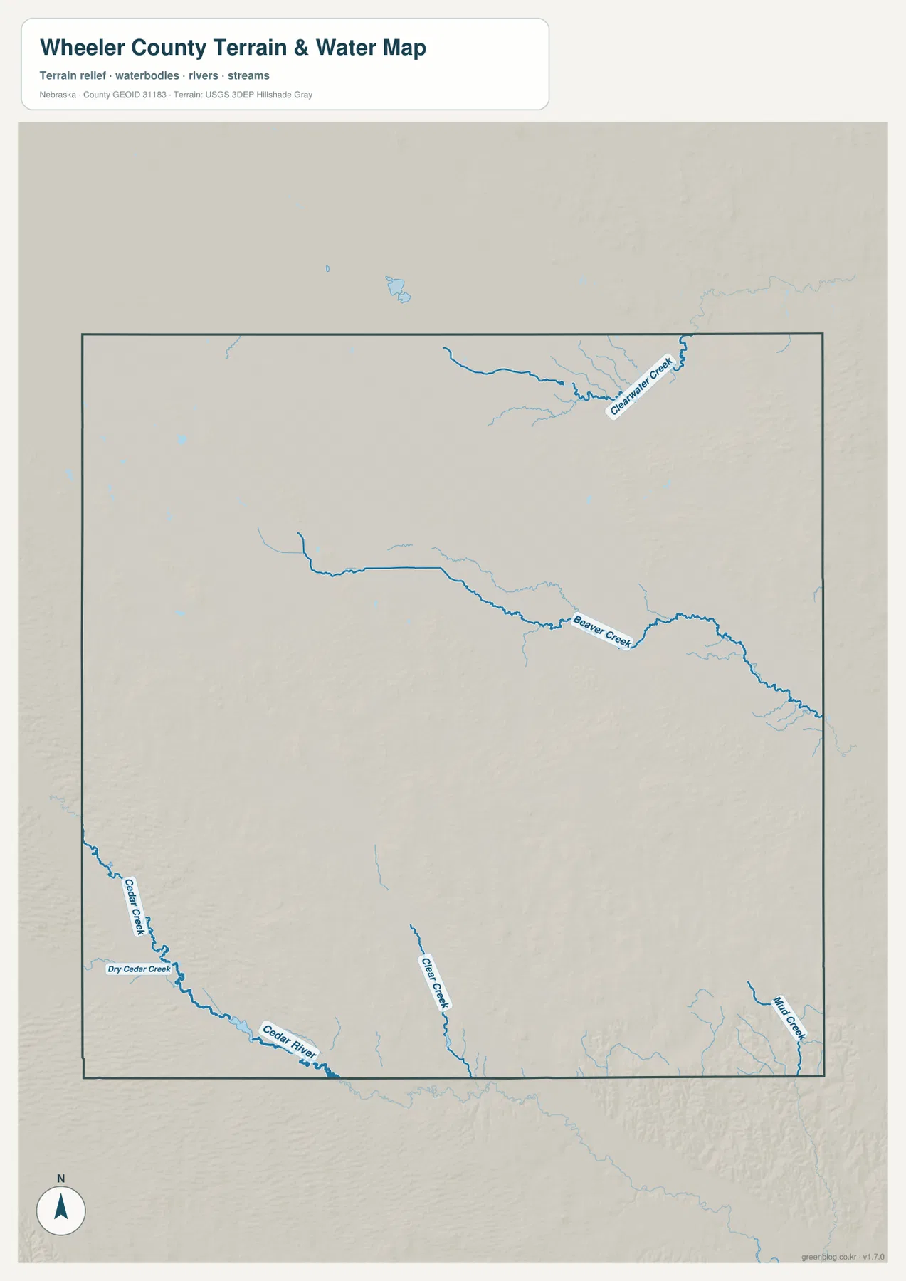
Wheeler County’s official history also records a long relationship between local water and settlement. During an 1895 irrigation project, a dam across Clear Creek created the lake that became known as Pibel Lake. The simplified county water map emphasizes the creek and river network rather than recreation-site detail, so visitors looking for the lake itself should use a current local recreation map or agency information.
Blue line thickness and color should not be treated as measurements of flow, depth, or flood risk. This image is designed to show where rivers, creeks, and channels are located at county scale. Floodplain decisions, stream access, water-use questions, and safety planning require current information from USGS, FEMA, or the relevant water-management agencies.
Southwestern Sandhills rise above lower northeastern country
The elevation map shows that Wheeler County is not a flat rectangle of ranchland. The displayed surface ranges from about 584 to 700 meters, with a mean near 640 meters. Warmer brown and orange colors are concentrated in the west and especially the southwest, while greens spread across the northeast as the county gradually drops in elevation.
The Cedar River occupies a lower green corridor through the high southwestern Sandhills. Long dune ridges rise on either side, creating some of the strongest relief on the map around the Ericson side. Beaver Creek forms another lower corridor across the center, but the surrounding surface remains rolling rather than becoming a broad flat plain.
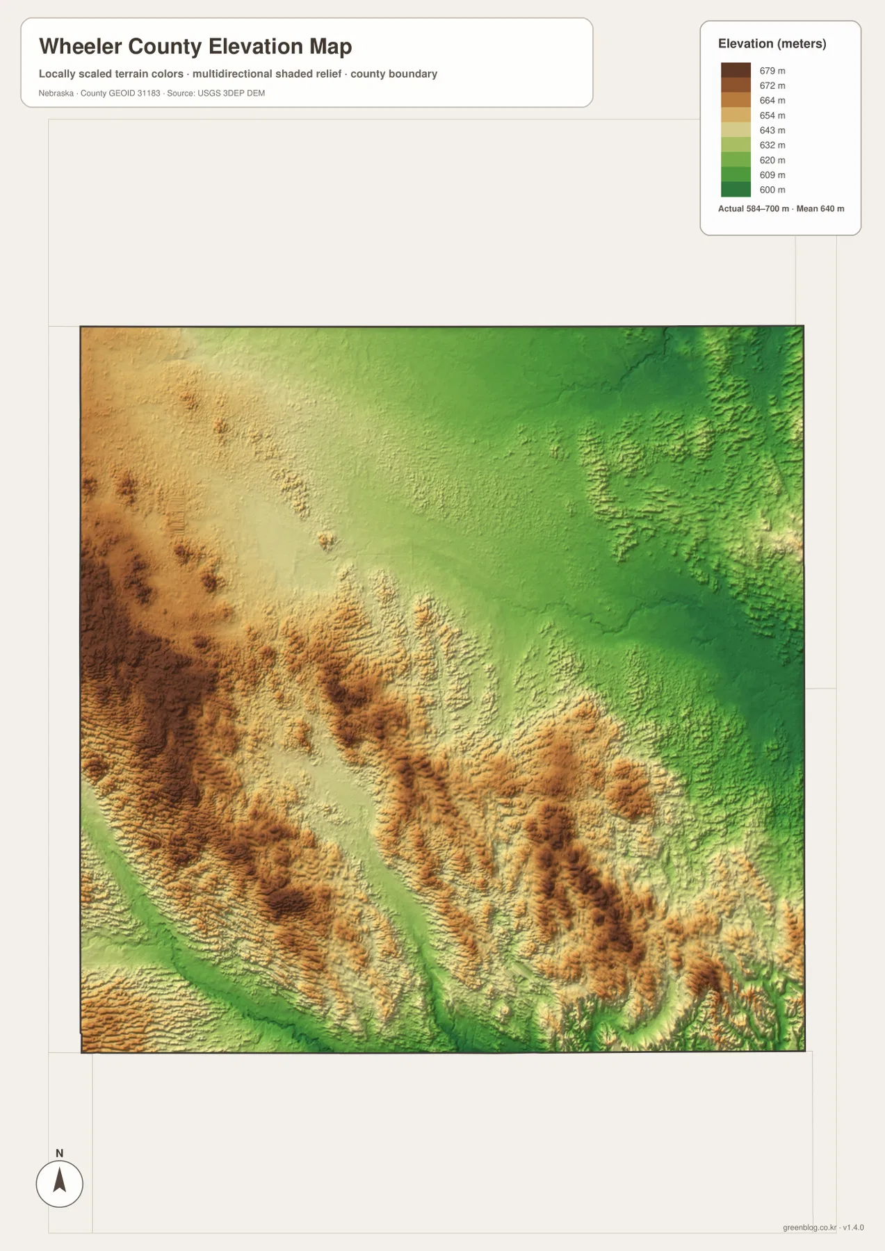
The northeast is lower overall, yet small ridges and tributary valleys remain visible in the shaded relief. Around Beaver Creek and Clearwater Creek, green corridors cut through the surrounding uplands. The west-to-east contrast is therefore more than a simple slope: it is a repeated pattern of grass-covered dunes separated by creeks and shallow valleys.
This elevation surface is intended for county-scale comparison, not parcel surveying or engineering. Exact site elevations, road grades, construction benchmarks, and design values require USGS source data, professional surveying, or another appropriate technical source. Here the map is most useful for comparing Bartlett’s central setting, the Cedar River valley near Ericson, the high southwestern dunes, and the lower northeastern half.
County-seat competition, the railroad era, and Pibel Lake history
Wheeler County’s official history says the county was organized in 1881 and originally included land that later became Garfield County. The present counties were separated as the area developed. Wheeler County was named for Major Daniel H. Wheeler, a longtime secretary of the Nebraska State Board of Agriculture.
The location of the county seat was a major local issue in 1885. Bartlett ultimately defeated Cumminsville in the county-seat election and became the center of county government. The Bartlett name is tied to Ezra Bartlett Mitchell, whose homestead was selected for the townsite. County offices remain in Bartlett today, which fits the village’s first-place position on the city panel.
Ericson grew in connection with late nineteenth-century railroad development. According to the county history, the railroad purchased land from Peter Erickson, laid out town lots, and named the settlement Ericson. Later irrigation and dam projects around the Cedar River and Clear Creek created additional local water features, including the origins of Pibel Lake.
Pibel Lake remains a recognized recreation water in Wheeler County and appears in Nebraska Game and Parks fishing information. The county map on this page is not intended to replace a fishing or recreation-site map, however. Current access, boating rules, camping conditions, and fish regulations should always be checked with the managing agencies before a visit.
A practical sequence for reading Wheeler County without overcomplicating it
Begin with the general county map by locating Bartlett and Ericson, then identify U.S. 281 and the Nebraska 70–91 corridor. The city panel provides an even simpler second view because it contains only the two ranked villages. Since the panel does not include distance connectors, it should not be used to estimate mileage.
Next, trace Beaver Creek across the center and the Cedar River in the southwest. Compare those same corridors on the elevation map to see how water occupies lower ground between Sandhills ridges. The strongest contrast appears in the southwest, where high dune country surrounds the Cedar River valley, while the northeast sits lower overall.
High-resolution JPG files are better suited to printing and close inspection when small road numbers and stream names matter. These maps remain regional references rather than legal or safety documents. County boundaries can be checked against Census TIGER/Line data, waterways against USGS National Hydrography, and elevation against the USGS 3D Elevation Program.
Frequently Asked Questions
Does the city map show a distance between Bartlett and Ericson?
No. The supplied city panel ranks Bartlett and Ericson and shows their locations, but it does not contain connector lines or a mileage table. Driving distance and travel time should be checked with current route information instead of inferred from the graphic.
Which waterways are most useful for understanding Wheeler County?
Beaver Creek provides the main central reference, while the Cedar River and Cedar Creek define much of the southwestern setting near Ericson. Clearwater Creek, Clear Creek, and Trail Creek add separate drainage corridors elsewhere in the county.
Is this water map detailed enough for a Pibel Lake fishing trip?
No. The county map provides regional context but does not show recreation facilities, access points, or current fishing rules in detail. Use current Nebraska Game and Parks or local recreation information when planning a Pibel Lake visit.
Map File Information
Download the four high-resolution JPG maps shown on this page for Wheeler County in one ZIP archive.
- Included Files: Use only the versions confirmed in the article and supplied images
- File Type: Use the confirmed download contents
- Intended Use: Printing, education, presentations, and map-based projects
Related Maps
Sources and references
County organization, Bartlett county-seat history, Ericson, and Pibel Lake background come from the official Wheeler County history. Current recreation-water information is cross-checked with Nebraska Game and Parks, while the federal sources below provide authoritative references for boundaries, hydrography, and elevation.
- Wheeler County – About Our County
- Nebraska Game and Parks – Fishing Guide
- U.S. Census Bureau – TIGER/Line Shapefiles
- USGS – National Hydrography
- USGS – 3D Elevation Program
Green Map creates custom-edited map images using open geographic data sources such as geoBoundaries, Natural Earth, OpenStreetMap, and government open data. These maps are edited visual materials, not raw data files, and are provided for education, documents, presentations, and graphic reference.