Sioux County occupies Nebraska’s far northwestern corner, where Harrison serves as the main community in a large landscape of ranchland, creek valleys, and high rolling terrain. This Sioux County Nebraska Map page combines the county boundary and road network with the locations of Harrison and Agate, the Niobrara and White rivers, named creeks, and an elevation view that reveals large differences between lower northern valleys and the higher central and southern country. The WebP previews are designed for quick viewing, while the same four maps can be downloaded below as high-resolution JPG files in one ZIP archive. High-resolution map files are available for download in the section below.
Harrison is the best place to begin reading the county. U.S. 20 crosses the northern part of Sioux County through Harrison, while Nebraska 29 runs south toward Agate and the Niobrara River country. Nebraska 71 appears in the far northeast. Because the county has very few major settlements, roads, rivers, and relief carry more geographic information here than a long list of towns would.
Table of Contents
Harrison where U.S. 20 meets the north-south route through Sioux County
The general county map makes Harrison the clear reference point. U.S. 20 crosses the county from west to east through the community and continues toward Crawford outside the eastern boundary. Nebraska 29 begins its long southward run from the Harrison area, passes near Agate, and continues through the central and southern parts of the county. In the northeast, Nebraska 71 reaches a much less populated section near the county edge.
Montrose appears as a small northern place label, while Crawford and Whitney provide orientation outside the county to the east. Henry and Nebraska 26 appear near the southern edge but outside the main county interior. The dark county boundary is therefore important when distinguishing locations inside Sioux County from surrounding reference points. The shape of the county is long north to south, so the road map is especially useful for judging how far Harrison is from the southern county line.
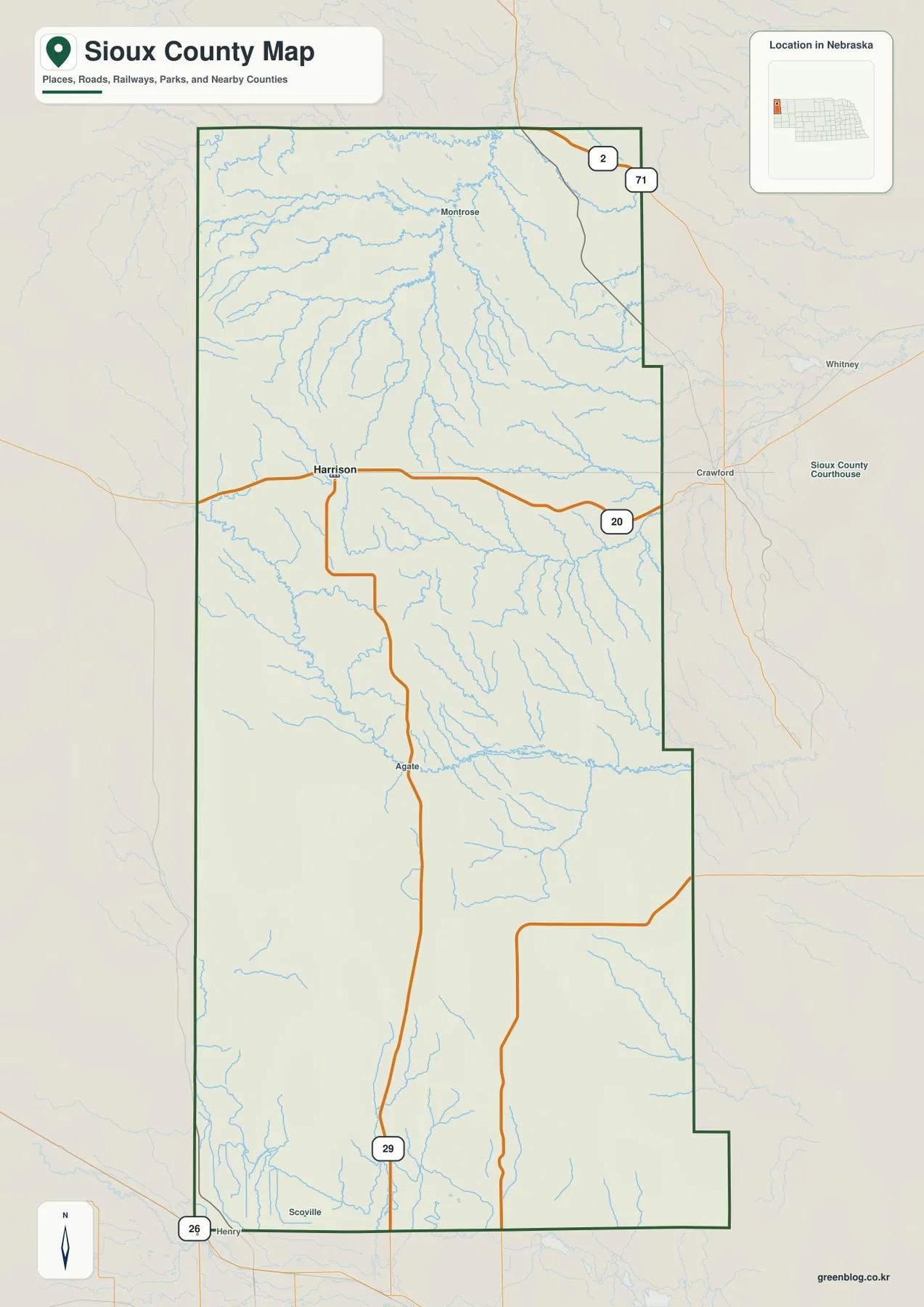
Nebraska 29 is the dominant internal route because it links Harrison with the much more sparsely settled center and south. The landscape along the route changes from the creek-cut northern country to the Niobrara River area near Agate and then into broad high ground farther south. A map focused only on towns would miss most of this variation, which is why the road, water, and elevation views work particularly well together in Sioux County.
The image is a regional reference rather than a live navigation product. Construction, weather, and road conditions can change, so actual travel should be planned with current transportation information. Its main value is orientation: it clearly shows where Harrison sits along U.S. 20, how Nebraska 29 reaches Agate, and how Nebraska 71 relates to the far northeastern corner.
A city index with Harrison as the only major urban reference
The ranked city map is unusually simple. Harrison is the only major city shown in the CITY INDEX, and no connector lines or intercity distance table are needed because there is no second ranked city to compare. That makes the map useful for a different reason: it emphasizes just how lightly settled the county is and places Harrison clearly in the northern third of a very large geographic area.
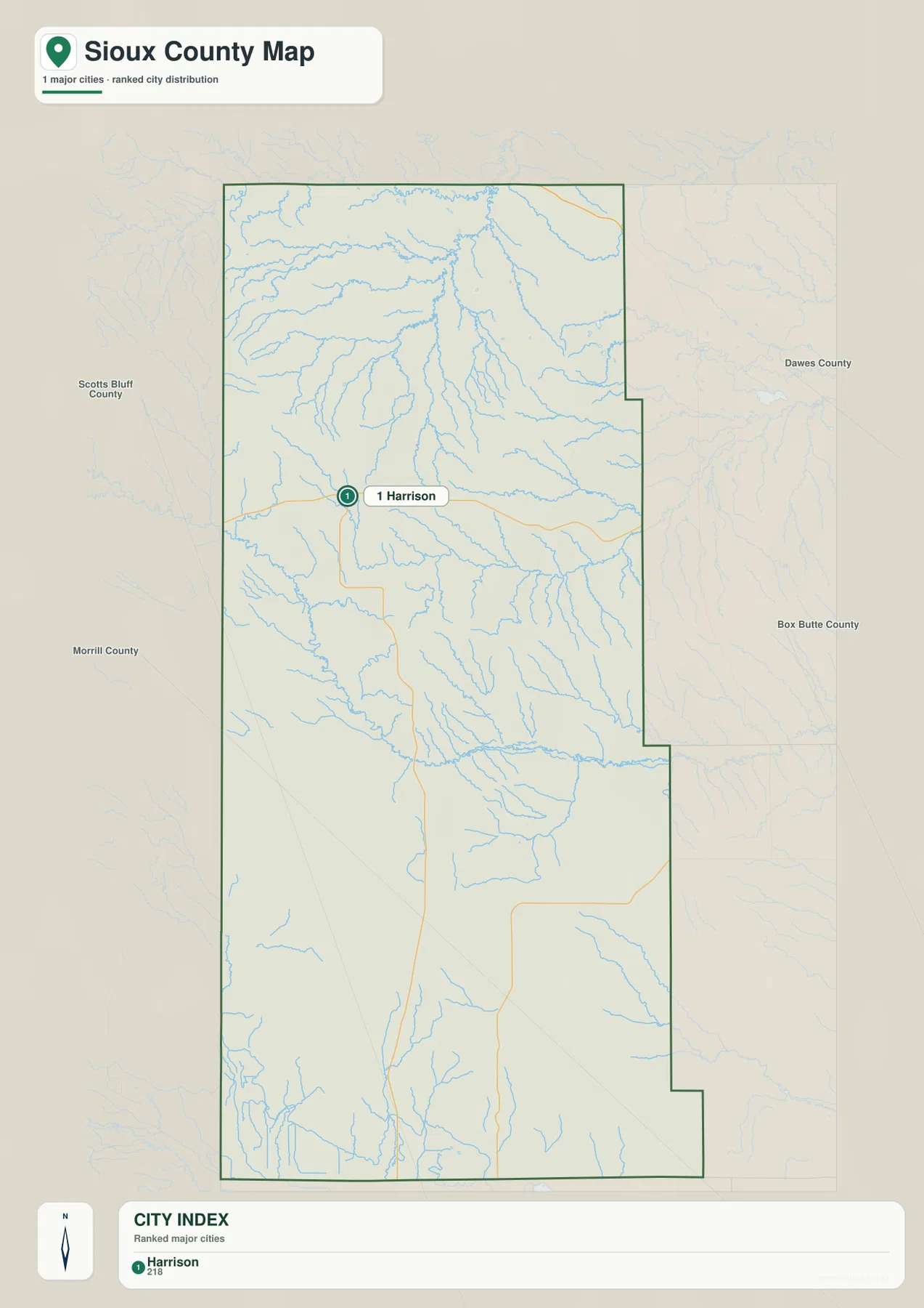
Harrison is also the county seat. The Sioux County comprehensive plan explains that the county was officially established in 1885 and that one of the railroad construction camps in the northern part of the county eventually became Harrison, the county seat. That history fits the present map well: Harrison remains positioned along the main east-west highway and serves as the principal named community for county-wide orientation.
The simplicity of the city map should not be mistaken for a lack of geographic variety. In Sioux County the most useful contrasts come from the terrain rather than from a dense urban network. After locating Harrison, the water and elevation maps reveal sharply dissected northern valleys, the Niobrara River corridor, and broad higher ground farther south.
White River tributaries in the north and the Niobrara River farther south
The water map is busiest in the northern half of the county. Indian Creek, Antelope Creek, Jim Creek, Hat Creek, Warbonnet Creek, and Grandmother Creek form a dense set of channels across the northern uplands. Soldier Creek and the White River appear farther east and south. The pattern shows why the northern landscape has so many narrow valleys and ridges even when the general road map looks relatively open.
The Niobrara River crosses the county farther south, running generally from west to east through the Agate area. Agate Fossil Beds National Monument occupies part of this river valley. The National Park Service describes the Niobrara as a spring-fed river that meanders through prairie and wetland inside the monument, while fossil-bearing hills rise above the valley. This makes the river corridor both a major physical feature and an important part of the county’s natural history.
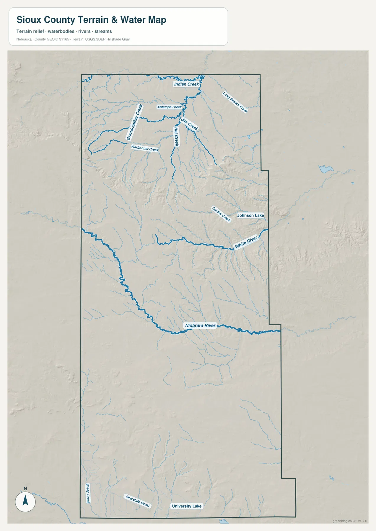
Sheep Creek appears near the southwest, while the Interstate Canal and University Lake are labeled near the southern edge. These features help orient the lower part of the county, but the map does not provide current canal operation, water level, access, or recreation status. Anyone needing those details should consult the agencies responsible for the water system or site.
Blue line width and color should not be interpreted as measurements of flow, depth, or flood risk. This map is designed to show where water features are located. Floodplain determinations, property restrictions, stream access, and water-right questions require current official information from USGS, FEMA, or the appropriate local and state agencies.
A wide elevation range from northern valleys to central and southern high ground
The elevation map shows a large range for a Nebraska county. The displayed surface runs from about 1,081 to 1,599 meters, with a mean near 1,355 meters. Greens dominate much of the north, while warmer yellow, orange, and brown colors expand across the central and southern portions. The west-central part of the county contains some of the darkest high terrain, creating a strong contrast with lower creek valleys.
The northern Pine Ridge area is not simply low and flat. Numerous streams cut into the landscape, producing green valleys separated by higher ridges. Farther south, broad uplands become more prominent until the Niobrara River creates another lower corridor. This combination of deeply cut northern terrain, high central ground, and river valleys explains why Sioux County looks much rougher on an elevation map than on a simple road map.
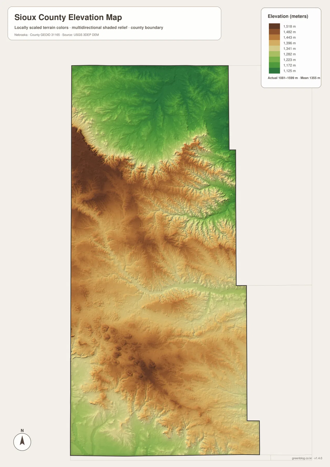
The southern half also contains narrow lower corridors, but much of the broad background remains elevated. When the elevation image is compared with the water map, the green channels generally line up with named rivers and creeks. That relationship makes it easier to understand how water has carved the county’s hills and why roads often follow valleys or avoid the roughest terrain.
This elevation surface is intended for county-scale comparison, not parcel surveying or engineering. Exact site elevations, road grades, construction benchmarks, and design values require USGS source data, professional surveying, or another appropriate technical source. Here the image is most useful for comparing Harrison’s northern setting with the Niobrara corridor and the higher interior uplands.
Agate Fossil Beds and the county’s ranching history
The Sioux County comprehensive plan describes fur traders and trappers entering the region in the 1830s, followed by more permanent settlement after Fort Robinson was established in 1874. Cattle ranches developed in the area, and the county was officially established in 1885. The same plan notes that ranching has remained a dominant land use, with native grasses covering a large share of the county and supporting grazing and hay production.
Agate Fossil Beds National Monument provides one of the county’s most distinctive natural-history landmarks. The National Park Service explains that early twentieth-century excavations uncovered exceptionally important Miocene mammal fossils, including nearly complete skeletons from the fossil hills. The monument also preserves the story of rancher James Cook and his relationship with Chief Red Cloud and other Lakota people.
The park occupies prairie along the Niobrara River, with fossil-bearing hills rising above the wetlands. NPS geologic information notes that Miocene rocks are exposed in the area and contain an unusually rich fossil record. The county maps on this page are not detailed visitor maps for the monument, but they provide useful regional context for understanding where Agate lies in relation to Harrison, Nebraska 29, and the Niobrara River.
Using the maps for printing, teaching, and regional reference
Start with the general county map when you need the boundary, roads, and named places in one view. Locate Harrison on U.S. 20, then follow Nebraska 29 south toward Agate. The city map is intentionally simple and works best for showing Harrison’s position within the long county rather than for comparing multiple urban centers.
Use the water map to compare the White River system in the north with the Niobrara River farther south. The elevation map then shows how those waterways occupy lower corridors within much higher surrounding terrain. In a classroom, students can first locate Harrison and Agate, trace the Niobrara River, and then compare the same area on the elevation image.
High-resolution JPG files are more useful than the WebP previews when printing or zooming in on small creek names and road labels. These maps remain regional references rather than legal or safety documents. County boundaries can be checked against Census TIGER/Line data, waterways against USGS National Hydrography, and elevation against the USGS 3D Elevation Program.
Frequently Asked Questions
Where is Harrison within Sioux County?
Harrison is in the northern part of the county along U.S. 20, where Nebraska 29 begins its southward route. It is the only major city shown in the ranked city map and serves as the county seat.
Do the Niobrara and White rivers cross the same part of the county?
No. The White River is farther north and east, while the Niobrara River crosses the county much farther south through the Agate area. Broad uplands and many smaller tributary valleys lie between the two river systems.
Can the elevation map be used for surveying or construction design?
No. It is intended to compare lower valleys and higher uplands at county scale. Exact site elevations, road grades, and engineering benchmarks require appropriate USGS source data or professional surveying.
Map File Information
Download the four high-resolution JPG maps shown on this page for Sioux County in one ZIP archive.
- Included Files: Use only the versions confirmed in the article and supplied images
- File Type: Use the confirmed download contents
- Intended Use: Printing, education, presentations, and map-based projects
Related Maps
Sources and references
County history and land-use background come from the Sioux County comprehensive plan. Agate Fossil Beds information comes from the National Park Service, while the federal sources below provide authoritative references for county boundaries, hydrography, and elevation.
- Sioux County – Comprehensive Plan
- National Park Service – Agate Fossil Beds National Monument
- U.S. Census Bureau – TIGER/Line Shapefiles
- USGS – National Hydrography
- USGS – 3D Elevation Program
Green Map creates custom-edited map images using open geographic data sources such as geoBoundaries, Natural Earth, OpenStreetMap, and government open data. These maps are edited visual materials, not raw data files, and are provided for education, documents, presentations, and graphic reference.