Rock County stretches across a large part of north-central Nebraska’s Sandhills, with Bassett serving as the county seat and the junction of U.S. Highways 20 and 183. The northern boundary follows the Niobrara River, while the interior includes the forks of the Elkhorn River, scattered Sandhills lakes, and broad ranch country. This Rock County Nebraska Map page shows those features through a general county map, a simplified settlement view, a water reference, and an elevation image. High-resolution JPG versions are also available in one ZIP file for printing or detailed viewing. High-resolution map files are available for download in the section below.
Bassett is the easiest place to use as an anchor. U.S. 20 runs east-west through the community, U.S. 183 extends south, and Nebraska Highway 7 connects toward the Long Pine and Niobrara Valley side of the county. Newport lies farther east along the same general U.S. 20 corridor. South of that northern travel belt, roads and named settlements become much more widely spaced as the landscape opens into the Sandhills.
Table of Contents
Bassett at the meeting point of U.S. 20 and U.S. 183
The county map makes Bassett the clearest transportation reference. U.S. 20 approaches from the Long Pine side, crosses the Bassett area, and continues east. U.S. 183 drops south from the same vicinity, while Nebraska 7 approaches from the west and northwest. Rock County’s official profile specifically notes that U.S. 20 and 183 meet in Bassett, helping explain why the county seat stands out on a map of an otherwise sparsely settled county.
East of Bassett, U.S. 20 provides the main connection toward Newport and the eastern county line. Rural roads branch away from this corridor in a much looser grid, especially toward the south. The contrast is useful because it shows that Rock County does not have a dense network of towns spread across its full area. Most of the obvious road-and-settlement activity is concentrated in the northern portion, while the long southern half is dominated by ranch roads, open land, and small water features.
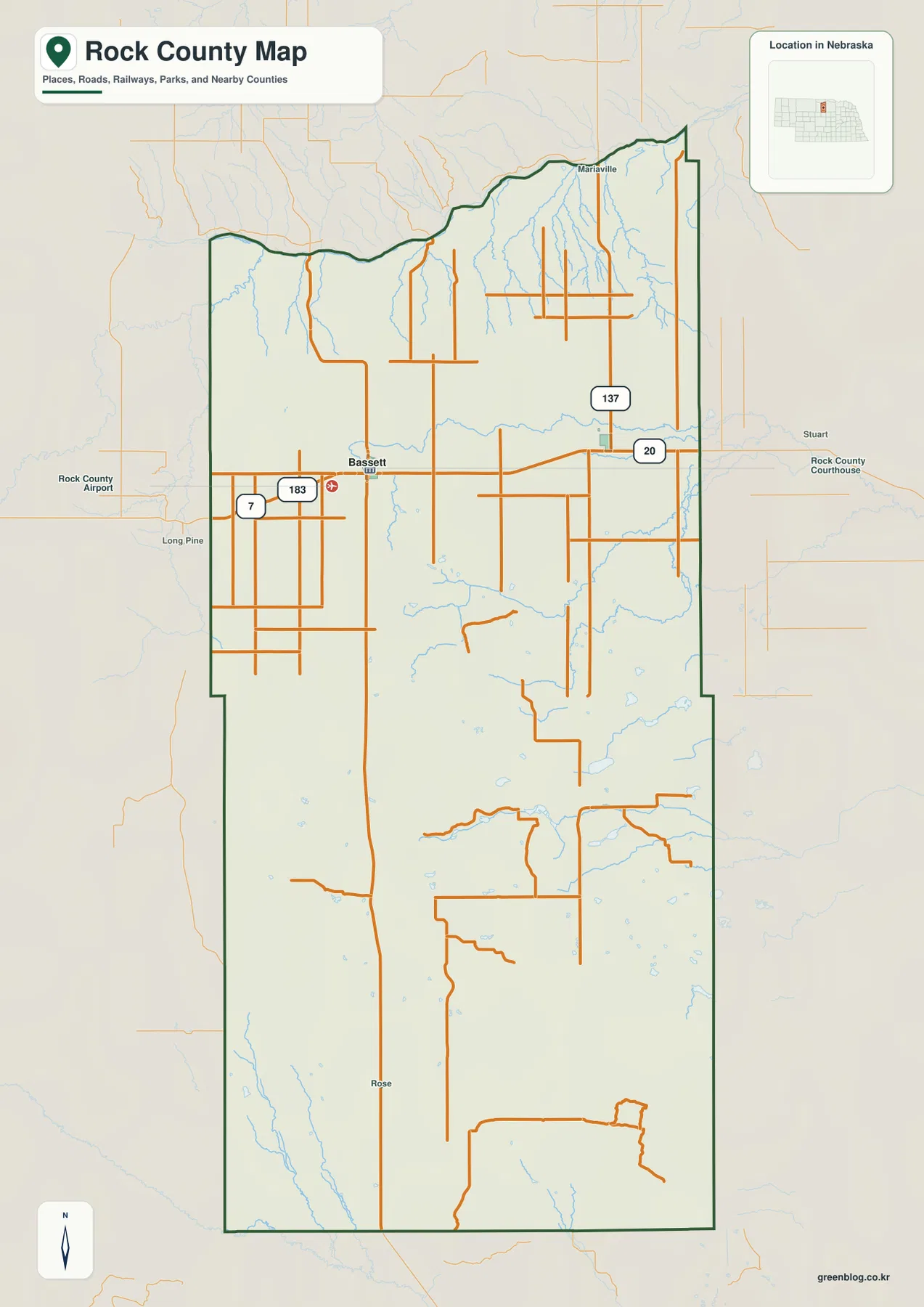
One of the most distinctive shapes is the northern county line. Rather than following a simple straight survey line, it bends and arcs across the top of the county. The official county website explains that the Niobrara River forms this northern boundary. That relationship is useful when reading the map because it connects the county outline directly to a major natural feature instead of treating the boundary as an abstract administrative line.
Labels outside the county, including Long Pine and Stuart, provide regional orientation but should not be confused with communities inside Rock County. The dark county boundary is the main visual guide for that distinction. For legal boundary work, parcel research, or a current GIS layer, the static image should be supplemented with U.S. Census Bureau TIGER/Line data or another current authoritative source.
A county where Bassett and Newport stand apart
The settlement map strips away much of the road detail and highlights only Bassett and Newport as the two principal communities. Bassett sits slightly west of the county’s northern center, while Newport lies farther east. The surrounding labels for Brown, Keya Paha, Holt, Boyd, Blaine, Garfield, and Loup Counties make the long north-south shape of Rock County especially clear and place it within the broader north-central Nebraska region.
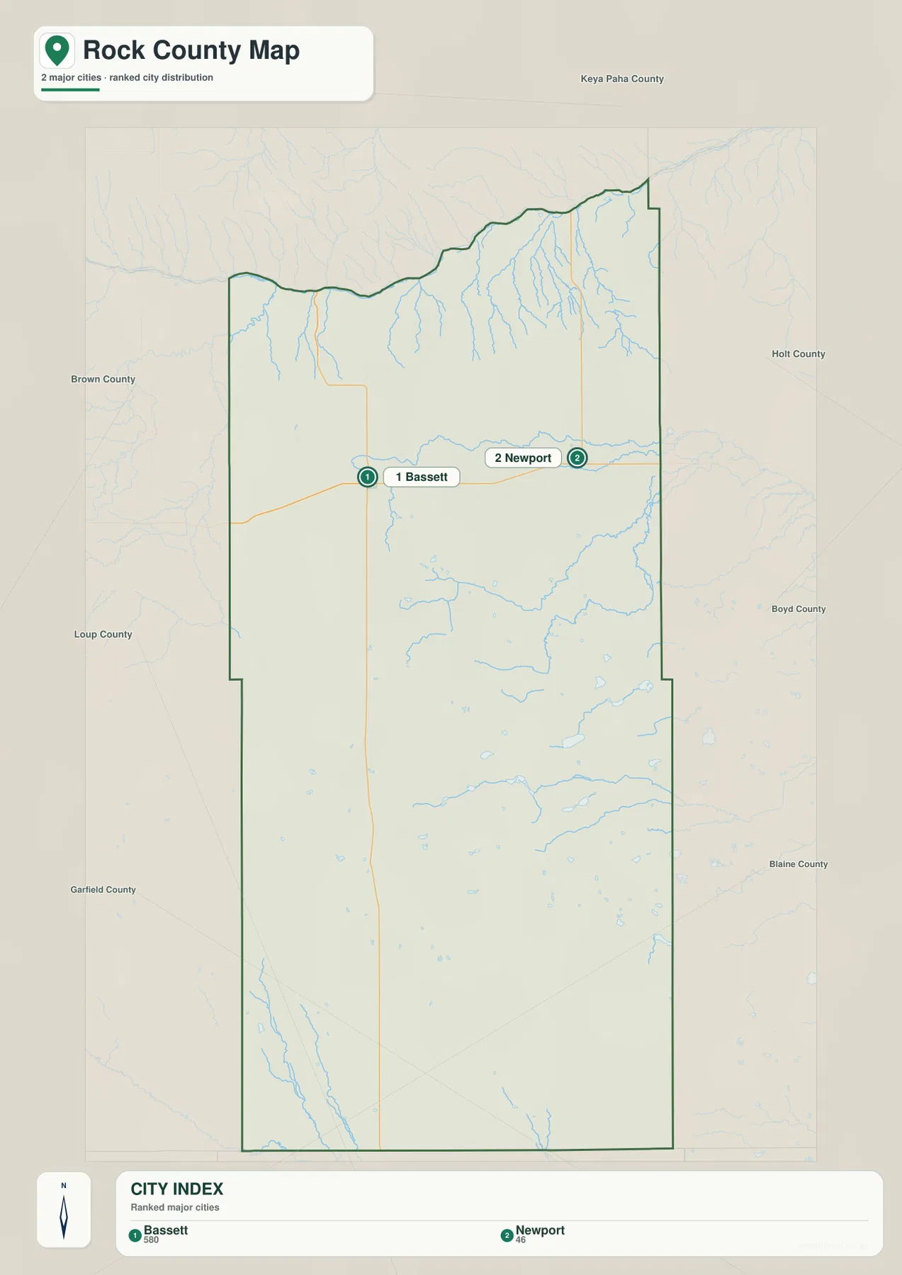
The CITY INDEX ranks Bassett first and Newport second for this map. Those numbers are map labels rather than a substitute for an official population table, so they are best used to identify the two places quickly. Rock County’s government site describes Bassett as the city and Newport as the village within the county. For current population estimates or municipal classification, readers should use Census or local government records rather than reading demographic meaning into the graphic itself.
The two communities also have a historical connection. Rock County was organized in 1888, and the county’s official history records that Bassett became the permanent county seat in 1889 after competition that included Newport and other communities. On the modern map, Bassett and Newport remain easy to compare because both sit in the northern road corridor, separated east-west rather than scattered across the much larger southern part of the county.
That sparse settlement pattern fits the county’s land use. The Nebraska Association of County Officials reports a land area of a little more than 1,008 square miles and a very high agricultural share, with grassland and livestock production especially important. The map does not classify individual ranches or fields, but the wide spaces between named places and the limited urban footprint are consistent with a Sandhills county built around extensive rural land rather than closely spaced towns.
Niobrara boundary, Elkhorn forks, and small Sandhills lakes
Water features give Rock County a more varied appearance than the road map alone suggests. Along the north, the Niobrara River defines the county edge and receives many short tributaries from the south. Farther inside the county, the North Fork Elkhorn River runs across the upper-middle section, bending eastward through open country. It is one of the most prominent labeled streams on the water map.
In eastern Rock County, the South Fork Elkhorn River curves northward toward the larger drainage, while an Elkhorn River label appears downstream. Dry Creek joins this system near the east, and Holt Creek is labeled farther south. The stream network is not dense everywhere, but it creates several narrow valleys through land that can otherwise look broad and open on the settlement map.
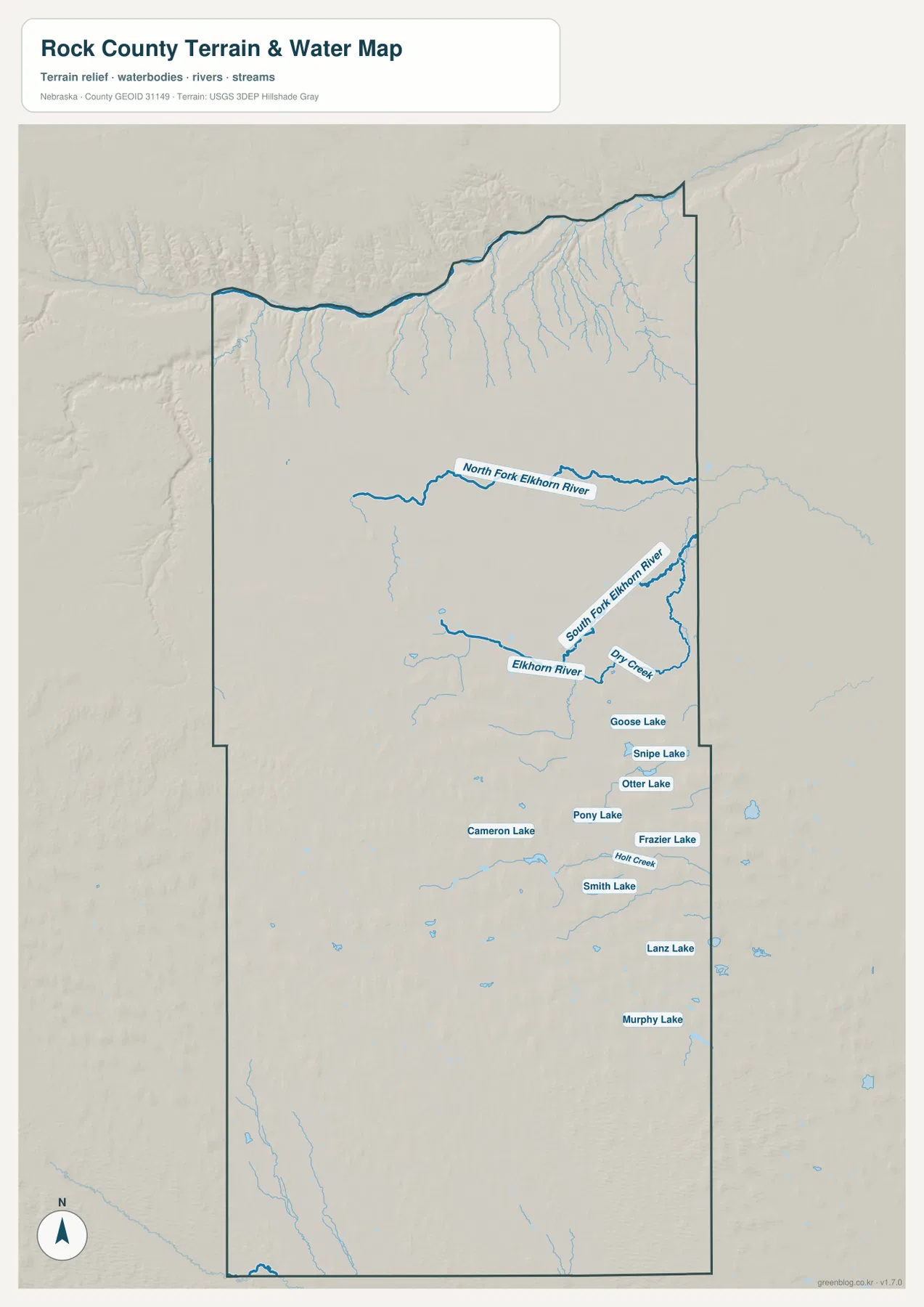
The southeastern half is especially notable for small lakes. Goose Lake, Snipe Lake, Otter Lake, Pony Lake, Frazier Lake, Cameron Lake, Smith Lake, Lanz Lake, and Murphy Lake are all labeled on the supplied map. Their scattered arrangement is characteristic of the Sandhills setting, where small basins can hold water amid rolling grass-covered dunes. The county’s official website also highlights local lakes and the Niobrara River as important natural features.
This image is a county-scale water reference, not a live report of lake level, streamflow, flood risk, public access, or fishing conditions. A lake label does not establish that a shoreline is publicly accessible, and line thickness does not measure discharge. For water management, floodplain decisions, or current recreation conditions, readers should check the appropriate state, local, or USGS sources. The map is most useful for understanding where named rivers, creeks, and lakes sit relative to one another.
Lower northern valleys and higher southern Sandhills
The elevation map reveals a strong north-to-south contrast. Dark green follows the low terrain near the Niobrara border and several northern tributary valleys. Moving toward the center, colors shift through green and yellow, then become orange and brown across much of the southwest and south. The legend reports an actual surface range of about 536 to 821 meters with a mean near 726 meters, showing that the county has substantial relief despite its broad Sandhills appearance.
The southwest contains the largest continuous area of higher ground. Small ridges and depressions repeat across the surface instead of forming one single mountain or plateau, giving the terrain the rolling texture associated with the Nebraska Sandhills. The southeast is also elevated in many places, although narrow valleys and lake basins interrupt the higher colors. These variations help explain why the water map shows many small lakes and channels even where major rivers are absent.
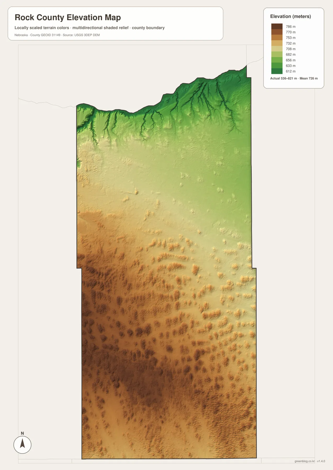
Along the northern edge, tributary valleys cut southward from the Niobrara boundary and appear as darker green fingers against higher surrounding ground. That texture aligns closely with the thin blue stream network on the water map. Looking at the two maps together makes it easier to see why the county’s northern outline is so irregular and why the southern half has a different visual character, with fewer large streams but many rolling uplands and small basins.
The elevation colors are intended for regional comparison rather than survey or engineering work. They should not be used to establish a parcel elevation, road grade, building benchmark, or construction design. Those uses require the underlying USGS 3D Elevation Program data, professional surveying, or another technical source. For general geography, the map is effective at separating the low river valleys from the higher Sandhills interior.
Ranch country shaped by roads, grassland, and water
Rock County’s official profile describes a county of just over 1,008 square miles in which agriculture covers about 92.5 percent of the land, with grassland and livestock production playing a major role. Those figures provide useful context for what the maps show. Large areas contain few settlement labels, the road grid is loose away from Bassett, and the landscape is broken more often by creeks, lakes, and Sandhills relief than by dense development.
Bassett functions as the practical center of this rural landscape. The courthouse, local airport, and highway junction sit close together in the northern part of the county. The official county site also highlights the annual Rock County Ranch Expo, reflecting the importance of ranching to local identity. The maps do not show agricultural production statistics, but they make the relationship between a small county seat and a very large surrounding ranch region easy to understand.
The Niobrara River adds a different kind of landscape along the county’s north side. Local sources describe fishing, hunting, and outdoor access associated with the river area. Nebraska Highway 7 and nearby roads provide a geographic link between Bassett and the northern valley, while the boundary itself follows the river’s bends. That combination of a highway crossroads, river border, and open grassland gives Rock County a recognizable pattern that differs from more densely settled Nebraska counties.
The small lakes in the southeast add another layer. They are not arranged along one large river but appear as individual water bodies scattered among the hills. On a classroom or regional comparison map, that cluster can be used to distinguish the lake-dotted Sandhills interior from the Niobrara corridor in the north and the Elkhorn drainage farther east. Exact lake size, ownership, or access should still be checked with current local or state sources.
Choosing the right Rock County map for the question
For general orientation, start with the county map and find Bassett at the U.S. 20–183 junction. From there, follow U.S. 20 east toward Newport and compare the straight southern and eastern boundaries with the winding Niobrara edge in the north. If settlement location is the only question, the simplified Bassett-and-Newport map removes much of the road detail and makes the county’s sparse population pattern much clearer.
Use the water reference when the focus is the Niobrara border, the North and South Forks of the Elkhorn River, or the cluster of southeastern lakes. The elevation image answers a different question by showing where the lower valleys and higher Sandhills lie. Matching the map to the question keeps the page easier to use than trying to read roads, streams, towns, and relief from one crowded image.
For classroom work, one useful sequence is to mark Bassett and Newport first, trace U.S. 20 between them, locate the Elkhorn River forks, and then compare those water features with the green lowlands on the elevation map. The high-resolution JPG files are better for printing and close inspection of labels than the WebP previews. These maps are suitable for education, regional reference, and personal projects, but legal boundaries, flood decisions, live navigation, and surveying require current authoritative data.
Frequently Asked Questions
Which map is the simplest way to compare Bassett and Newport?
The settlement map is the clearest choice because it strips away much of the road detail and highlights Bassett and Newport directly. Use the general county map when you also need U.S. 20, U.S. 183, Nebraska 7, and the surrounding county boundary.
Why does the northern Rock County boundary have so many bends?
The official county profile states that the Niobrara River forms the northern boundary. The county line therefore follows the river’s winding course instead of a straight survey line, which creates the irregular shape visible along the top of the map.
Does the water map show current lake access or water levels?
No. It shows the approximate locations and names of features such as Goose Lake, Snipe Lake, Otter Lake, and Frazier Lake. Current water levels, public access, fishing rules, and property restrictions should be checked with the appropriate state or local agency.
Map File Information
Download the four high-resolution JPG maps shown on this page for Rock County, Nebraska, in one ZIP archive.
- Included Files: Use only the versions confirmed in the article and supplied images
- File Type: Use the confirmed download contents
- Intended Use: Printing, education, presentations, and map-based projects
Related Maps
Sources and references
County-seat history, the Niobrara boundary, agriculture, highways, and local background were checked against Rock County and Bassett sources. The federal links below provide authoritative references for boundaries, hydrography, and elevation.
- Rock County – About Our County
- Rock County, Nebraska Official Website
- Bassett, Nebraska – History & Facts
- U.S. Census Bureau – TIGER/Line Shapefiles
- USGS – National Hydrography
- USGS – 3D Elevation Program
Green Map creates custom-edited map images using open geographic data sources such as geoBoundaries, Natural Earth, OpenStreetMap, and government open data. These maps are edited visual materials, not raw data files, and are provided for education, documents, presentations, and graphic reference.