Saline County lies in southeastern Nebraska, where Crete and Wilber anchor a network of smaller communities and the Big Blue River follows the lower eastern side of the county. This Saline County Nebraska Map page combines roads and county boundaries with the locations of Crete, Wilber, Friend, Dorchester, DeWitt, and Western, plus the Big Blue River, Turkey Creek, Swan Creek, and the elevation contrast between the higher west and the lower river country in the east. The WebP images are for quick viewing, while the same four maps can be downloaded below as high-resolution JPG files in one ZIP archive. High-resolution map files are available for download in the section below.
Crete in the northeast and Wilber in the east-central part of the county are useful anchors for reading the region. Nebraska 33 links Crete with Dorchester and Friend across the north, while Nebraska 41 crosses the Wilber area. Western lies much farther southwest and DeWitt sits toward the southeast. The official Saline County website also lists Crete, DeWitt, Dorchester, Friend, Swanton, Tobias, Western, and Wilber among the county’s communities, showing how settlement is spread across several parts of the county rather than concentrated in one cluster.
Table of Contents
Roads and communities from Crete to Friend and Wilber
The general county map makes Crete the most prominent place in the northeast. Nebraska 33 enters from the west, passes near Friend and Dorchester, and continues toward Crete, creating a clear east-west frame for the northern part of Saline County. Wilber provides a second anchor farther south, while Nebraska 74 and Nebraska 15 help organize the southwestern road pattern near Western.
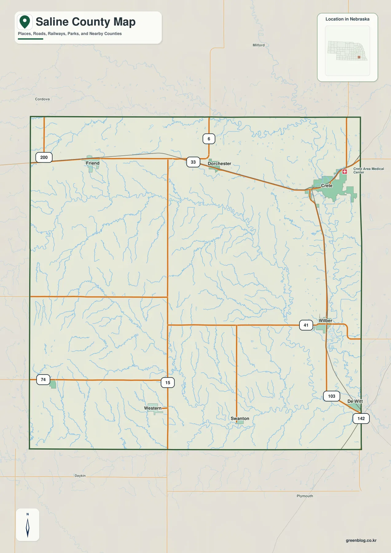
Wilber is the county seat. Saline County’s official history explains that the seat was first located at Swan City, then moved to Pleasant Hill, and finally shifted to Wilber after a series of elections in 1877. On the modern map, Wilber occupies a practical east-central position between Crete to the north and DeWitt to the southeast. Labels such as Milford, Plymouth, and Daykin are useful orientation points outside the county but should not be mistaken for Saline County communities.
The road map is a regional reference rather than a live navigation product. Construction, closures, and seasonal conditions may change after a static map is produced. Its strength is in comparing the Crete–Dorchester–Friend corridor in the north, the Wilber–DeWitt area in the east, and the more widely spaced rural routes of the south and west.
How Crete, Wilber, Friend, and the smaller communities are distributed
The city-distribution map removes much of the road detail and highlights six larger communities. Crete occupies the northeast and ranks first on the map, with Wilber next in the eastern part of the county. Friend and Dorchester form the northern pair farther west, while DeWitt and Western are separated across the southern half. The simplified layout makes community spacing easier to understand than on a busier transportation map.
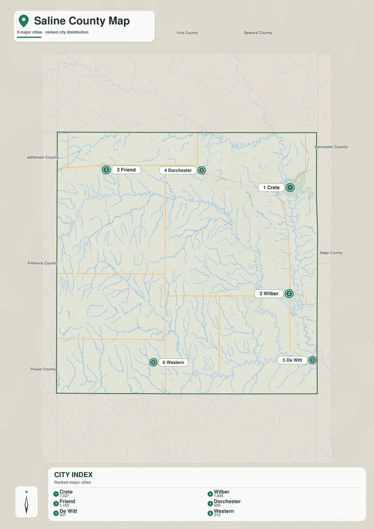
The ranked panel places Crete ahead of Wilber, followed by Friend, Dorchester, DeWitt, and Western. Those rankings are useful for relative scale, but current population estimates should come from the latest Census data rather than a static graphic. The geographic lesson is more important here: Crete and Wilber sit closer to the lower eastern drainage country, while Friend and Western occupy higher ground farther west.
The county website lists eight communities, while this map emphasizes six of the larger ones. Swanton and Tobias are therefore better located on the general map or through county information. A map designed to compare major population centers does not need to give every settlement the same visual weight, and understanding that difference helps avoid confusing “not emphasized” with “not present.”
Big Blue River, Turkey Creek, and the Swan Creek drainage
The water map is dominated by the Big Blue River along the eastern side of Saline County. The West Fork Big Blue River approaches from the north, while Turkey Creek crosses the central part of the county from west toward the Big Blue system. These waterways help explain why the east appears lower on the elevation map and why the Crete and Wilber areas sit near a dense network of tributaries.
Dry Branch and Spring Creek feed the central drainage, with Brush Creek and Dry Creek farther east. In the south, North Fork Swan Creek and South Fork Swan Creek form a separate set of valleys, while South Fork Johnson Creek appears in the northwest and Wilson Creek near the northeast. The many smaller channels show that the county is divided by rolling stream valleys rather than being a uniformly flat plain.
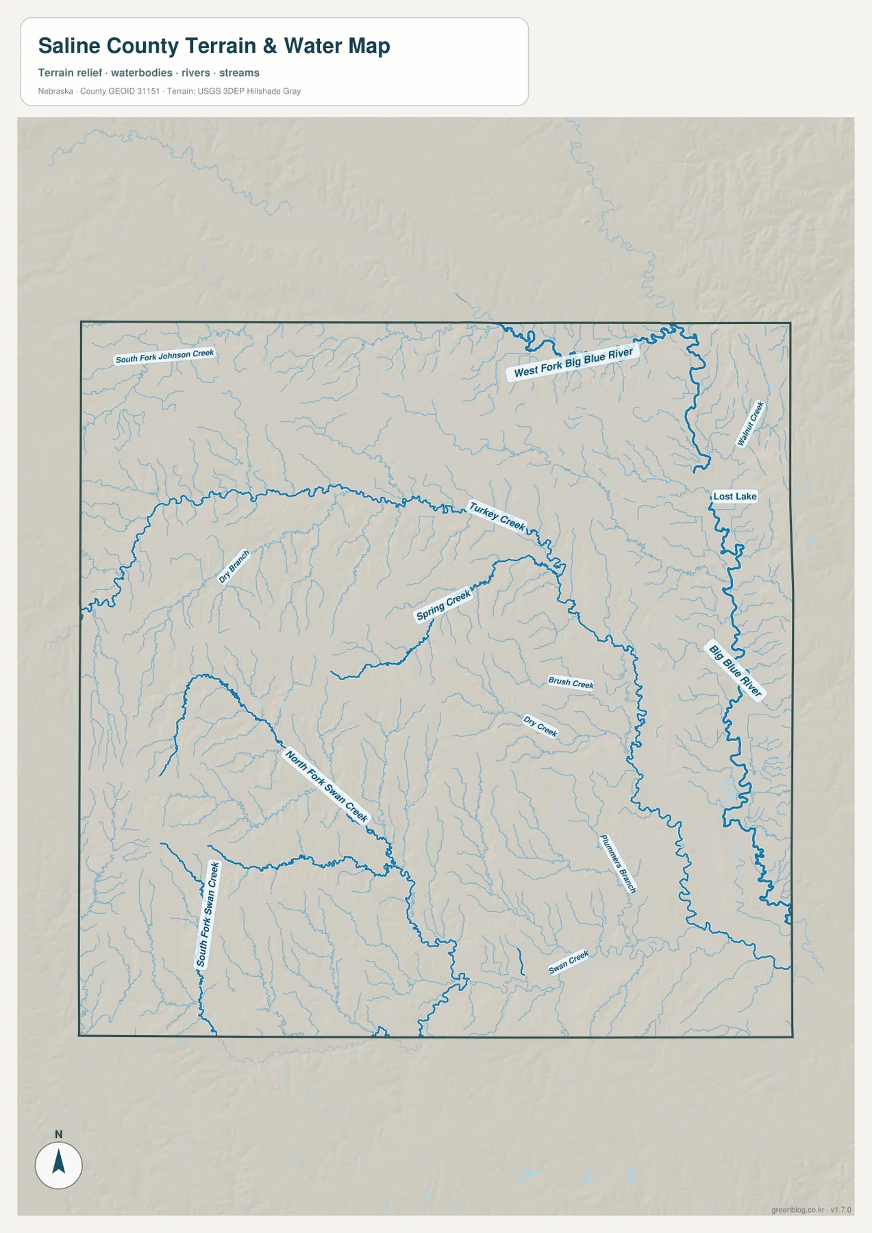
Lost Lake is also labeled on the eastern side. The county’s official information page notes numerous NRD dams and structures in the Swan Creek Watershed, with some locations developed for public use. Willard L. Meyer Recreation Area, also known as Swan Lake, is one example highlighted by the county. Because the supplied image is not a recreation-status map, current access, boating rules, and amenities should be checked through the appropriate local agencies.
Blue line width and color do not measure discharge, depth, or flood danger. Floodplain decisions, stream access, water rights, and safety questions require current official data from the responsible agencies. For general geography and classroom work, however, the map gives a clear county-wide view of the Big Blue River and its tributary network.
Higher western hills and the lower Big Blue River side
The elevation map shows a strong west-to-east contrast. Brown and orange cover much of the west and southwest, while green dominates the lower terrain near the Big Blue River in the east. The mapped surface ranges from about 389 to 505 meters, with a mean near 446 meters. The exact values provide context, but the most useful visual lesson is the broad descent from the western uplands toward the eastern river valleys.
Turkey Creek creates a broad lower corridor through the center. North and south of it, smaller tributaries cut narrow valleys into the rolling land. The Big Blue River corridor on the east is wider and lower, producing a long green strip. Crete and Wilber lie near this lower country, while Friend and Western are surrounded by more elevated terrain farther west.
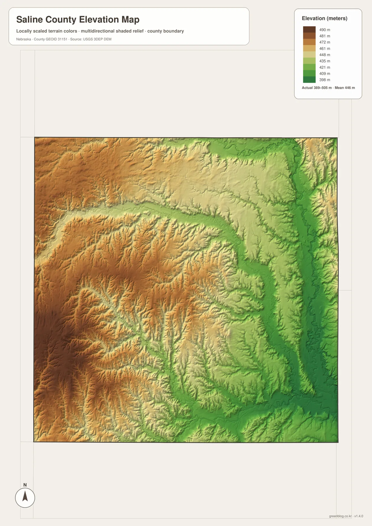
The southern Swan Creek system and the northern West Fork Big Blue River drainage produce additional lower corridors. Comparing the water and elevation maps makes the relationship clear: named streams generally occupy the lower parts of the terrain. This image is intended for county-scale comparison, not parcel surveying, building benchmarks, road grades, or engineering design.
Wilber’s county-seat history and local context
Saline County was created in 1855 during the territorial period and formally organized in 1867. The county’s official history says the name came from an early belief that large salt springs or deposits would be found in the area, although that expectation proved incorrect. The story adds useful historical context to a county whose modern maps are more visibly shaped by the Big Blue River and its tributaries.
The county-seat story is especially distinctive. Swan City served first, followed by Pleasant Hill. In 1877, repeated elections narrowed the competition until Wilber defeated Crete, and county records were moved to Wilber soon afterward. On the present map, both Wilber and Crete are prominent eastern communities, making the historic rivalry easy to place geographically.
Wilber is also associated with Czech-American heritage, and the county website directs visitors to Nebraska Czechs of Wilber as part of its community information. Cultural history is not directly shown on the four supplied maps, but the map provides the geographic starting point for deeper research. Crete, Friend, Dorchester, DeWitt, Western, Swanton, and Tobias provide additional reference points across the county.
Choosing the right map for printing, classes, and regional reference
Start with the general county map when you need roads, communities, the boundary, and nearby place labels in one view. The city-distribution map is cleaner when the question is simply where the larger communities lie relative to one another. For waterways, the Big Blue River and Turkey Creek are easiest to follow on the terrain-and-water image.
The elevation map answers a different question by showing why the eastern river side is lower and the western side is higher. Comparing Crete and Wilber with Friend and Western is a simple way to connect settlement position with terrain and drainage. In a classroom, students can first locate communities and highways, then trace the river network, and finally compare the same places on the elevation image.
High-resolution JPG files are better suited to printing and close inspection than the WebP previews when small stream names and route numbers matter. These maps remain regional references rather than legal or safety documents. County boundaries can be checked against Census TIGER/Line data, waterways against USGS National Hydrography, and elevation against the USGS 3D Elevation Program.
Frequently Asked Questions
Which map is easiest for comparing Crete, Wilber, and Friend?
The city-distribution map is the simplest choice because it removes most road detail and highlights the major communities directly. Crete is in the northeast, Wilber is farther south in the east, and Friend is toward the northwest. Use the general county map when you also need route numbers and road connections.
Where do the Big Blue River and Turkey Creek run through Saline County?
The Big Blue River follows the eastern side of the county, while Turkey Creek crosses the central area from west toward the Big Blue system. The water map also labels the West Fork Big Blue River, Swan Creek branches, and several smaller tributaries.
Why is western Saline County higher than the eastern side on the elevation map?
The west contains more elevated rolling terrain, while the east is lowered by the Big Blue River and its tributary valleys. The map is designed for broad comparison only and should not be used as a parcel-level survey or engineering elevation source.
Map File Information
Download the four high-resolution JPG maps shown on this page for Saline County in one ZIP archive.
- Included Files: Use only the versions confirmed in the article and supplied images
- File Type: Use the confirmed download contents
- Intended Use: Printing, education, presentations, and map-based projects
Related Maps
Sources and references
County-seat, community, history, and Swan Creek recreation background comes from the official Saline County website. Federal sources below provide authoritative references for county boundaries, hydrography, and elevation data.
- Saline County – About Our County
- Saline County – History
- U.S. Census Bureau – TIGER/Line Shapefiles
- USGS – National Hydrography
- USGS – 3D Elevation Program
Green Map creates custom-edited map images using open geographic data sources such as geoBoundaries, Natural Earth, OpenStreetMap, and government open data. These maps are edited visual materials, not raw data files, and are provided for education, documents, presentations, and graphic reference.