Perkins County occupies a broad rural area in southwestern Nebraska, with Grant serving as the main reference point and Madrid and Elsie continuing east along the county’s principal highway corridor while Venango sits near the western edge. This Perkins County Nebraska Map page brings together the county boundary and road network, the relative positions of four principal communities, named creeks, and a clear elevation transition from higher western ground toward lower drainage country in the east. The WebP images are designed for quick viewing, and the download box below provides the same map set as high-resolution JPG files in one ZIP archive.
The easiest way to organize the county at first glance is to follow Nebraska Highway 23. It runs from the Venango side of the county through Grant, Madrid, and Elsie, while Highway 61 crosses the route at Grant and extends north and south. The city-index map simplifies those four communities, and the water and elevation maps add the physical setting behind the road pattern. Together they show that the county is not simply a flat rectangular grid: stream valleys become more intricate toward the east, and the overall land surface drops noticeably from west to east.
Table of Contents
Highway 23 links Venango, Grant, Madrid, and Elsie
The general county map is dominated by the east-west route of Nebraska Highway 23. Venango lies close to the western edge, Grant occupies a more central position, and Madrid and Elsie continue along the same corridor to the east. Nebraska Department of Transportation records confirm this sequence with N-23 segments identified from the Colorado line through Venango and Brandon to Grant, then onward toward Madrid and Elsie. That makes Highway 23 a practical geographic spine for reading the county even when the map includes many smaller numbered roads.
Highway 61 provides the major north-south contrast. It meets Highway 23 at Grant and continues across the county boundary in both directions. On the map, that intersection makes Grant stand out as more than one stop on an east-west line; it is also a junction for traffic moving north and south. Other road numbers such as 314, 316, 324, 760, 761, 343, 333, and 350 appear around different parts of the county. They are useful for locating road segments on this map, but readers should consult current state and local records for route status, construction, or maintenance information.
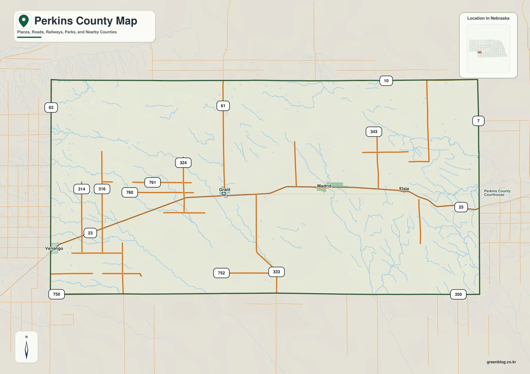
Light blue stream lines add an important second layer to the road map. Western and central parts of the county contain long, relatively open drainage lines, while the eastern side shows a denser branching pattern. A straight road grid can make the county look uniformly level, but the waterways reveal many shallow valleys and divides. The area east and southeast of Elsie is especially useful for seeing how small tributaries break up the surface before reaching larger named creeks.
This map is best used for county-scale orientation rather than turn-by-turn navigation. Road conditions, closures, construction, access rules, and surface types can change, so a current Nebraska road source should be checked before a trip. For classroom use, printed county references, local-history context, or a quick comparison of settlement locations, the map works well because it keeps the major roads, communities, county outline, and drainage background together on one page.
Four communities form a simple east-west settlement pattern
The city-index map removes most of the road detail and emphasizes Grant, Madrid, Venango, and Elsie. Grant is marked as number 1, Madrid as 2, Venango as 3, and Elsie as 4. Perkins County’s official website also identifies Grant, Elsie, Madrid, and Venango as its cities and villages, so the map’s four highlighted places provide a useful framework for describing the county’s current settlement pattern without inventing additional urban centers.
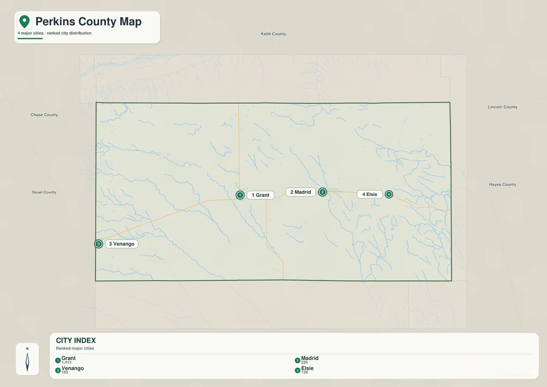
The index also prints numeric values beneath the community names, but those should be treated as values used by the map rather than assumed to be current census counts. Anyone needing present population figures should check the latest Census release directly. For this page, the more durable information is spatial: Venango and Elsie sit near opposite ends of the county, with Grant and Madrid between them, and all four line up closely with the Highway 23 corridor.
That alignment makes the city map unusually easy to compare with the road map. Grant is near the junction with Highway 61, Madrid is farther east along Highway 23, Elsie is still farther east, and Venango anchors the western side. Even so, the straight-line appearance of the city points should not be confused with actual driving distance. Rural roads can bend, merge with other routes, cross drainage channels, or change surface, so the index is most useful for answering the simple question of where one community lies relative to another.
The physical setting becomes more apparent when the city map is compared with the next two maps. Venango and Grant are associated with the higher western and central part of the county, while Madrid and especially Elsie approach the lower, more densely dissected eastern terrain. That distinction is difficult to see from settlement points alone. The creek network and elevation colors explain why one long highway corridor can pass through noticeably different local landscapes within the same county.
Sand Creek, Sinking Water Creek, and the eastern drainage network
The terrain-and-water map labels several waterways that give Perkins County more geographic detail than the road map alone can provide. Sand Creek and Spring Creek appear in the southwest, Sinking Water Creek runs through the central portion of the county, Red Willow Creek crosses the northeast, and Blackwood Creek occupies the eastern side farther south. Rather than converging on one large river within the county, these named creeks belong to a dispersed pattern of drainage corridors that head in different directions.
Sand Creek enters the western side and continues generally southeast, with Spring Creek labeled along the lower part of the same broad drainage area. Numerous smaller tributaries approach these channels without every minor stream receiving a name on the map. The western drainage lines are comparatively open and elongated, matching the broad higher surface seen later on the elevation map. They make shallow cuts through the upland rather than creating one dominant valley.
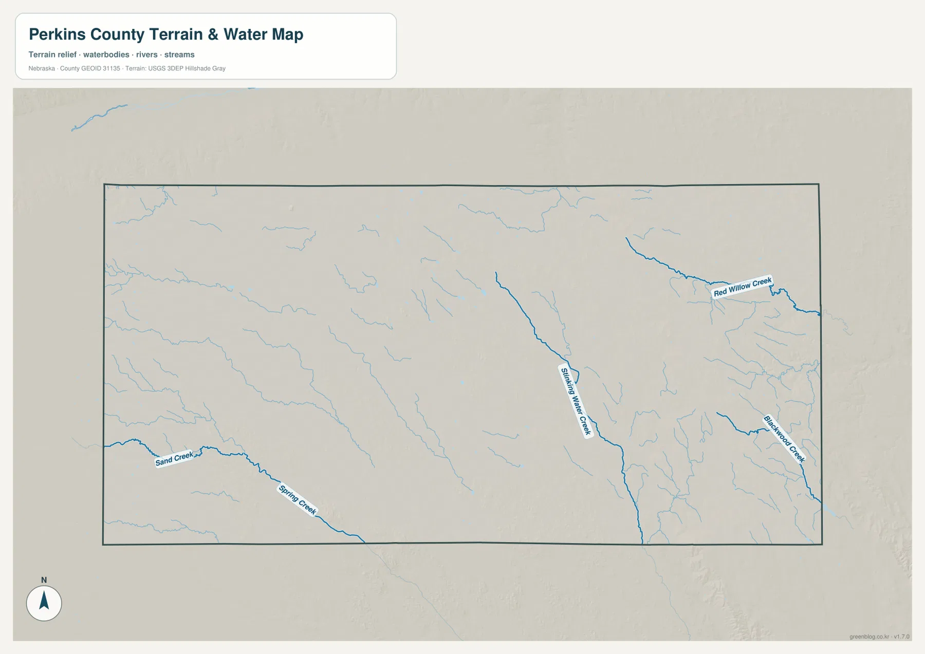
Sinking Water Creek is one of the most prominent central features because it traces a long north-south course. Smaller branches extend toward it from surrounding higher ground, so the creek forms a useful link between the water map and the relief pattern. In the northeast, Red Willow Creek follows a more distinct east-west corridor before leaving the county. Blackwood Creek and a dense set of smaller eastern tributaries occupy lower terrain farther south and help explain the intricate blue network visible around the Elsie side of the general map.
The water map is intended to show names and approximate county-scale relationships. A line’s thickness is not a measurement of stream width or depth, and the map does not report real-time flow, flood stage, water quality, fishing rules, irrigation rights, or public access. Those questions require current information from USGS and the relevant Nebraska agencies. For regional orientation, however, the map is effective because it separates named waterways from the road system and makes the branching drainage pattern easy to compare.
One practical way to use the map is to connect the creeks back to the settlement corridor. Grant and Madrid occupy the central part of the county near the transition to the Sinking Water Creek drainage, while Elsie is closer to the more densely branched eastern network associated with Red Willow Creek and Blackwood Creek. Venango lies in the higher western country where Sand Creek and Spring Creek help define the local valleys. Those relationships make the county’s east-west change easier to understand than a list of community names alone.
Elevation falls from the western High Plains toward eastern creek valleys
The elevation map makes the west-to-east transition unmistakable. Its legend uses representative color steps from about 976 meters to 1,099 meters, while the map reports an actual surface range of roughly 953 to 1,111 meters and a mean near 1,034 meters. Brown and orange dominate the western side, indicating higher ground, while yellow-green and green become progressively more common toward the east. The county therefore has a broad eastward drop, although the surface is broken by many valleys rather than sloping as one smooth plane.
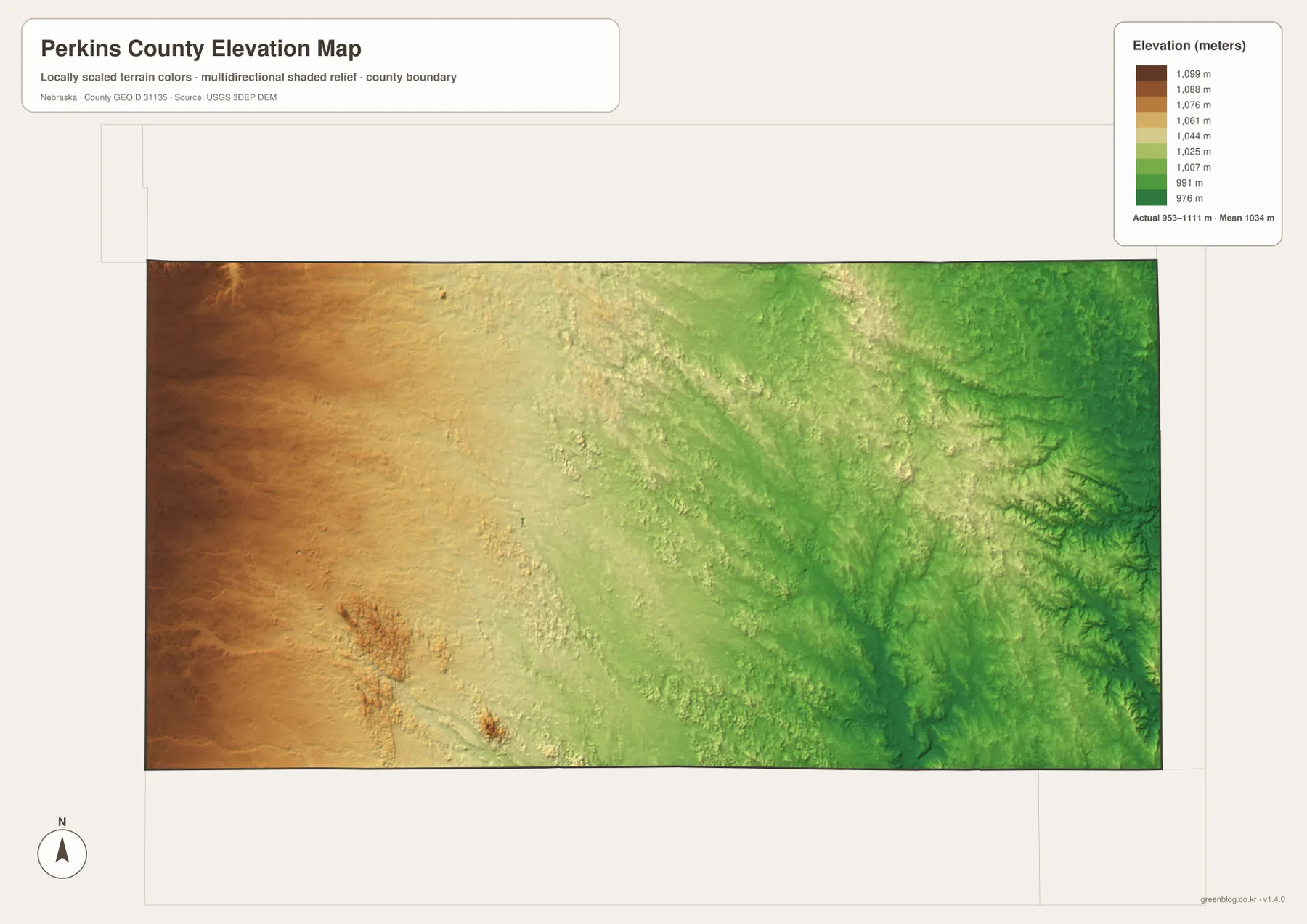
The western half looks broad and elevated, but narrow lower bands cut into it. Those bands correspond well with the creek corridors shown on the water map, including the Sand Creek and Spring Creek area. This is an important correction to the idea that the High Plains are perfectly flat. Around Venango and west of Grant, the overall surface is high, yet local drainage still creates shallow valleys, low swales, and subtle ridges that are visible in the shaded relief.
Near the middle of the county, the color pattern becomes more mixed. Sinking Water Creek occupies a lower corridor running through the transition, and smaller tributaries reach into it from both sides. East of this central zone, green shades spread more widely. Madrid sits near the transition, while the terrain around and east of Elsie contains a finer network of low drainage cuts. Comparing the water and elevation maps side by side shows that the named creeks generally occupy the lower bands rather than crossing the high areas at random.
Red Willow Creek and Blackwood Creek lie within the lower eastern part of the county, where green valleys branch repeatedly into surrounding ground. This creates a more dissected appearance than the broad western upland. A trip along Highway 23 therefore crosses more than a sequence of towns: it also moves from higher western terrain toward a lower and more finely divided eastern landscape. That broad pattern is one of the most distinctive features visible across the four maps.
The elevation image is a generalized county-scale visualization and should not be used to establish parcel elevations, construction grades, drainage design, legal boundaries, or survey control. Those tasks require appropriate USGS source data, official records, and professional field work. For classroom explanation, county comparison, route context, or understanding why stream corridors occupy particular areas, the map provides a clear visual summary without implying engineering precision.
Grant’s county-seat role adds historical context to the modern map
Perkins County’s official website identifies Grant, Elsie, Madrid, and Venango as the county’s cities and villages. The same four places are emphasized on the city-index map, which makes the modern settlement pattern straightforward to connect with local government information. Grant also contains the county courthouse and appears at the intersection of the two most prominent highways on the map, reinforcing its usefulness as the central reference point for readers unfamiliar with the area.
A Nebraska State Historical Society archives guide adds earlier context. It describes settlement increasing during the 1880s, an 1887 election that organized the new county after division from Keith County, and a special election in 1888 that selected Grant as the county seat. Those details help explain why Grant remains such a prominent map reference today. They also show that the modern road-and-town pattern sits on more than a century of county development.
The historical record includes former post offices, railroad activity, and other communities that are not the focus of these present-day map images. The maps on this page are not historical reconstructions and should not be used to locate vanished settlements, nineteenth-century property boundaries, or former rail alignments. Instead, they provide a current geographic framework of roads, communities, water, and relief that can make separate historical sources easier to place spatially.
Perkins County is especially useful for this kind of comparison because its principal communities are spread along a long rural corridor rather than concentrated into one continuous urban area. Between the towns are large expanses of agricultural land, local roads, and shallow drainage valleys. The city map simplifies that pattern into four points, while the water and elevation maps fill in the terrain between them. Using all four views prevents the county from being reduced to either a road grid or a list of place names.
Choose the map that matches the question
Use the general county map when the task is to compare roads, county boundaries, communities, and the broad stream network in one view. It is the best starting point for tracing Highway 23 from Venango through Grant to Madrid and Elsie or for seeing where Highway 61 crosses the county. The city-index map is better when road detail would be distracting and the main question is simply how the four principal communities are positioned relative to one another.
Choose the terrain-and-water map for Sand Creek, Spring Creek, Sinking Water Creek, Red Willow Creek, and Blackwood Creek. It emphasizes named waterways and branching tributaries much more clearly than the general map. Choose the elevation map for the larger physical pattern: higher western ground, lower eastern valleys, and the relationship between creek corridors and relief. The water and elevation maps are particularly informative when viewed together because the lower green bands generally align with the drainage network.
For printing, presentations, or classroom materials, it is often clearer to select the map that fits the topic rather than shrinking every image onto one page. The downloadable JPG originals are 3638×2572 pixels each, providing more room for labels than the WebP previews on this page. Higher resolution does not turn them into parcel, survey, flood-control, or engineering products, so specialized decisions should still rely on the appropriate authoritative source.
Frequently Asked Questions
Which map is best for comparing Grant, Madrid, Elsie, and Venango?
The city-index map is the simplest choice because it strips away most other detail and shows the four communities in a clear west-to-east arrangement. Use the general county map next if road connections matter. It shows Highway 23 linking the four places and Highway 61 crossing at Grant.
Where is the west-to-east elevation change easiest to see?
The elevation map shows it most clearly. Brown and orange higher terrain dominates the west, while green lower terrain becomes more extensive toward the east. Pair it with the terrain-and-water map to see how Sinking Water Creek, Red Willow Creek, Blackwood Creek, and other drainage corridors occupy many of the lower bands.
Can the downloadable elevation map be used for surveying or construction?
No. It is a generalized county-scale visualization of relative relief, not a survey or engineering product. Parcel elevations, construction grades, drainage requirements, and legal boundaries require suitable USGS data, official records, and professional surveying rather than the colors in this map.
Map File Information
Download the four high-resolution JPG maps shown on this page for Perkins County in one ZIP archive.
- Included Files: Use only the versions confirmed in the article and supplied images
- File Type: Use the confirmed download contents
- Intended Use: Printing, education, presentations, and map-based projects
Related Maps
Sources and references
County settlement information comes from the official Perkins County website, while the county’s early organization and Grant’s county-seat history are summarized from the Nebraska State Historical Society archives guide. Road context is supported by Nebraska DOT, with federal sources listed for boundary, hydrography, and elevation data.
- Perkins County official website
- Nebraska State Historical Society – Perkins County archives guide
- Nebraska Department of Transportation – Highway Log Book
- U.S. Census Bureau – TIGER/Line Shapefiles
- USGS – National Hydrography
- USGS – 3D Elevation Program
Green Map creates custom-edited map images using open geographic data sources such as geoBoundaries, Natural Earth, OpenStreetMap, and government open data. These maps are edited visual materials, not raw data files, and are provided for education, documents, presentations, and graphic reference.