DeKalb County in northwestern Missouri is a compact rural county where small communities are separated by rolling farmland, branching creeks, and a handful of important highways. Maysville works as the clearest reference point, with Stewartsville and Osborn to the south, Union Star in the northwest, Clarksdale to the west, and Weatherby to the east. The page combines road, city, water, and elevation views so the same places can be compared from several angles. High-resolution JPG versions of the map set are also available together in one ZIP for printing, enlargement, or offline reference. High-resolution map files are available for download in the section below.
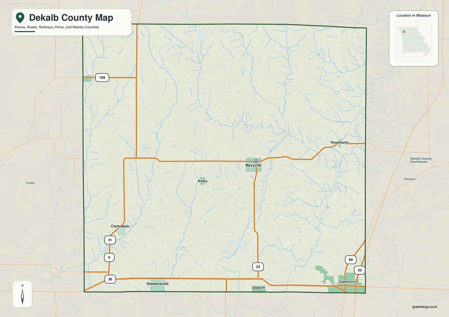
The general county map makes the spacing of the communities easy to understand. Maysville sits near the middle, Osborn and Stewartsville line the southern side near U.S. 36, and Weatherby lies well to the east. Union Star is close to the northwestern edge, while Clarksdale occupies the western side near Routes 6 and 31. Cameron appears just beyond the southeastern edge, next to I-35 and U.S. 69. Roads are useful landmarks here, but the creeks and valleys add another layer that becomes much clearer on the terrain and elevation maps.
Table of Contents
Use Maysville as the main reference point
Maysville is the easiest town to use for orientation because the DeKalb County Courthouse is marked there and Route 33 runs south toward Osborn. An east-west road continues from the Clarksdale side through Maysville toward Weatherby, giving the county a strong central line for comparison. Farther northwest, U.S. 169 clips the county edge, while the southeastern corner is close to U.S. 69 and I-35 near Cameron.
The southern boundary is especially easy to recognize because U.S. 36 crosses the county from west to east. Stewartsville lies near the western part of that route, and Osborn is closer to the middle. Around Clarksdale, Route 31 and Route 6 provide additional landmarks. These labels do not replace live navigation or current road-condition information, but they are excellent for seeing which communities share the same general corridor and which are separated by larger rural areas.
How the six ranked communities are distributed
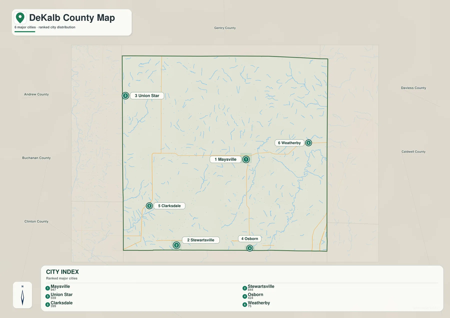
The city distribution map ranks Maysville first, Stewartsville second, Union Star third, Osborn fourth, Clarksdale fifth, and Weatherby sixth. Those numbers are map-ranking markers rather than mileage or travel-time measurements. The pattern is geographically useful: Maysville is near the middle, Stewartsville and Osborn occupy the south, Union Star is near the northwestern edge, Clarksdale sits to the west, and Weatherby stands alone in the east.
This spread makes DeKalb County very different from a county dominated by one continuous urban area. The six communities are separated by farmland, small roads, and creek valleys, so the ranked city map works best as a quick index. After finding a numbered place, readers can return to the general map to see the nearest state or U.S. route and then compare the water and elevation maps for the surrounding terrain.
Lost Creek defines much of the central drainage
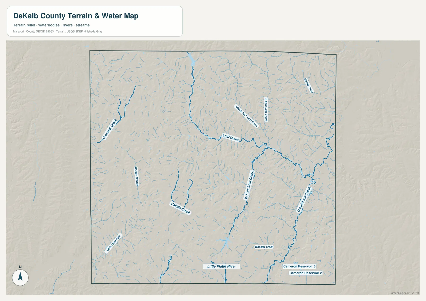
Lost Creek is one of the most prominent named waterways on the terrain-and-water map. It crosses the central and eastern part of the county, receiving Middle Fork Lost Creek and East Fork Lost Creek from the north and West Fork Lost Creek from the south. The branching network creates a long low corridor that becomes even more obvious on the elevation layer, where green tones trace the valley through otherwise rolling ground.
The relationship is especially clear between Maysville and Weatherby. A road connects the two communities across the county, but the water map reveals the creek branches that cut through the land between them. Moving farther southeast, Grindstone Creek becomes a major feature and continues toward the Cameron Reservoir area. Cameron Reservoir 2 and Cameron Reservoir 3 are labeled near the southeastern edge, adding useful local water landmarks.
Little Platte River and the western creeks
The Little Platte River appears along the southern part of the county, while Little Third Fork enters the southwest. Castle Creek is labeled in the west-central interior, and Crooked Creek runs through the northwestern side. Jordan Branch provides another named reference in the west. Together these waterways show that DeKalb County is not organized around one dominant river; instead, many smaller creeks divide the rolling uplands into short ridges and narrow valleys.
Baker Creek is labeled in the northeast, and Wheeler Creek appears farther south and east. Numerous smaller unnamed channels fill the spaces between the larger labels. The result is a dense network of shallow valleys that explains the textured relief visible on the elevation map. For readers looking at Union Star or Clarksdale, the western creeks are particularly helpful because they provide landmarks where the road pattern alone can feel sparse.
Elevation ranges from about 237 to 338 meters
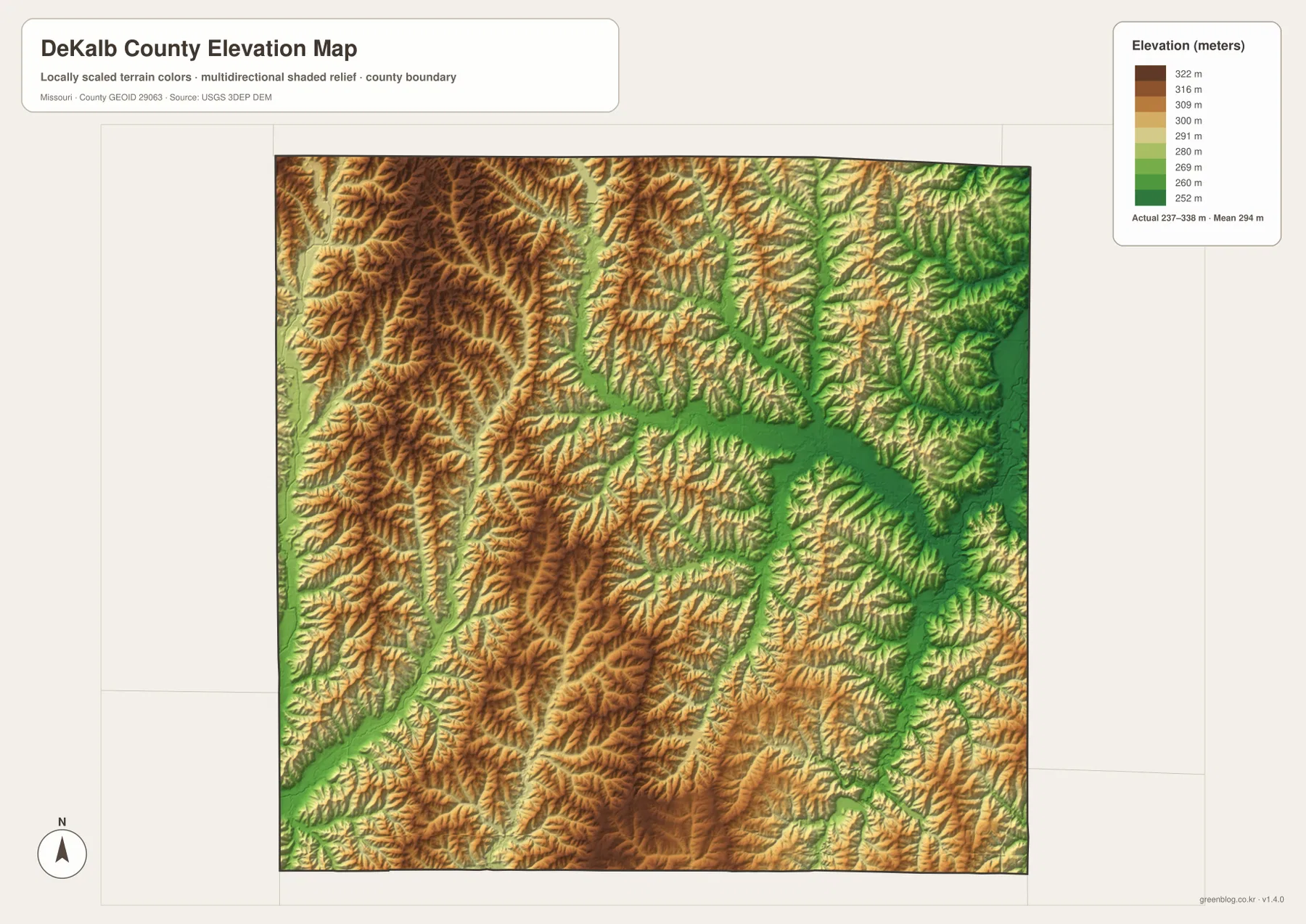
The elevation map reports an actual range of roughly 237 to 338 meters, with a mean near 294 meters. Higher ground is widespread in the west and southwest, where tan and brown ridges form a dense pattern. Lower elevations are concentrated along the Lost Creek system and other major valleys in the east and southeast. The county therefore looks like rolling upland cut by many stream corridors rather than a flat plain.
The Maysville and Union Star side contains many higher ridges, while the Weatherby side includes broader green valleys. The southern edge also drops along the Little Platte River and smaller tributaries. There is no single mountain ridge dominating the county; instead, the topography is made of repeated rises and dips between closely spaced creeks. Comparing the elevation layer with the water map makes those relationships easy to see without relying on technical terrain terminology.
Maysville and Weatherby show the east-west contrast
Maysville and Weatherby provide a useful comparison because they sit on the same broad east-west side of the road network but occupy different terrain settings. Maysville is the county-seat reference point with several roads meeting nearby. Weatherby lies farther east, where Lost Creek and smaller tributaries create a wider low corridor. Switching from the road map to the water and elevation layers makes that contrast much more obvious than the town labels alone.
The western side tells a different story. Union Star sits close to the northwestern border, while Clarksdale lies farther south near Routes 6 and 31. Higher rolling ground is more extensive in that part of the county. Comparing these locations shows why DeKalb County cannot be summarized by a single landscape type: the eastern creek valleys and the western ridges are both important parts of the same county.
Stewartsville, Osborn, and the U.S. 36 corridor
The southern edge is organized around U.S. 36, making Stewartsville and Osborn easy to locate. Stewartsville is toward the southwest, while Osborn lies nearer the south-central portion of the county. Route 33 leaves the Osborn area and runs north toward Maysville. Farther east, the highway approaches the Cameron area, where I-35 and U.S. 69 provide another major regional connection just beyond the county line.
Water and relief add context to this road corridor. The Little Platte River follows the southern side, while Grindstone Creek drains the southeastern interior. The elevation layer shows that U.S. 36 crosses a landscape of low valleys and modest ridges rather than a uniformly flat surface. That information is useful for geographic reference, although current travel conditions, bridge restrictions, and road work should always be checked with a live transportation source.
Choosing the right map file
The general county map is the quickest choice for community names, courthouse location, highway numbers, and nearby counties. The ranked city map simplifies the settlement pattern into six highlighted places. The terrain-and-water map is better for Lost Creek, Grindstone Creek, Little Platte River, Cameron Reservoirs, and the smaller named tributaries. The elevation map is the clearest view of the contrast between western ridges and lower eastern valleys.
The download ZIP contains high-resolution JPG versions of all four map themes. The on-page WebP previews are convenient for quick browsing, while the JPG files are better for enlarging labels or printing a reference sheet. They can also be placed side by side in a classroom handout or personal research document. These maps are geographic reference products, not substitutes for real-time navigation, flood alerts, engineering surveys, or legal parcel boundaries.
Official sources for additional context
DeKalb County’s official website provides county government information from the courthouse in Maysville, matching the courthouse location shown on the general map. For geographic data, the U.S. Census Bureau TIGER/Line program provides boundary and road layers, USGS National Hydrography covers rivers and streams, and the USGS 3D Elevation Program supplies elevation data. Those sources are useful when a reader needs to move from this visual overview to more specialized official datasets.
Frequently Asked Questions
What is the easiest place to use as a reference in DeKalb County?
Maysville is the clearest starting point. It is near the center of the county, contains the marked DeKalb County Courthouse, and connects easily to Osborn, Weatherby, and the western side through the mapped road network.
Do the numbers on the city map represent driving distance?
No. They rank six highlighted communities—Maysville, Stewartsville, Union Star, Osborn, Clarksdale, and Weatherby. The numbers are not mileage, road distance, or travel-time values.
What elevation range does the DeKalb County map show?
The elevation layer shows an actual range of about 237 to 338 meters, with a mean near 294 meters. Lower terrain follows Lost Creek, Grindstone Creek, and other valleys, while higher ridges are more extensive in the west and southwest.
Map File Information
Download the map files associated with this page for reference, printing, and compatible visual projects.
- Included Files: Use only the versions confirmed in the article and supplied images
- File Type: Use the confirmed download contents
- Intended Use: Printing, education, presentations, and map-based projects
Related Maps
Sources and references
- DeKalb County, Missouri Official Website – county government and courthouse information in Maysville
- U.S. Census Bureau TIGER/Line Shapefiles – boundary and road data
- USGS National Hydrography – rivers, creeks, and reservoir data
- USGS 3D Elevation Program – elevation data
Green Map creates custom-edited map images using open geographic data sources such as geoBoundaries, Natural Earth, OpenStreetMap, and government open data. These maps are edited visual materials, not raw data files, and are provided for education, documents, presentations, and graphic reference.