Lake of the Woods County occupies one of Minnesota’s most unusual geographic settings. Baudette and Williams lie on the southern mainland, while the Northwest Angle extends far north across Lake of the Woods. The county combines a huge international lake, widely spaced settlements, river-and-wetland lowlands, and a noticeably higher southwestern interior.
This page uses the supplied county, city, water, and elevation maps to explain those local relationships with the actual roads, communities, bays, rivers, and terrain shown in the package. Original high-resolution JPG versions are also available together in one ZIP download for printing, classroom work, presentations, or image editing.
Table of Contents
Baudette anchors the southern road network
Baudette is the easiest place to begin on the general county map. The city sits close to the eastern county edge and functions as the county seat, while several numbered county roads spread south and west from the surrounding area. Williams lies farther west, and Roosevelt provides another reference closer to the Roseau County side.
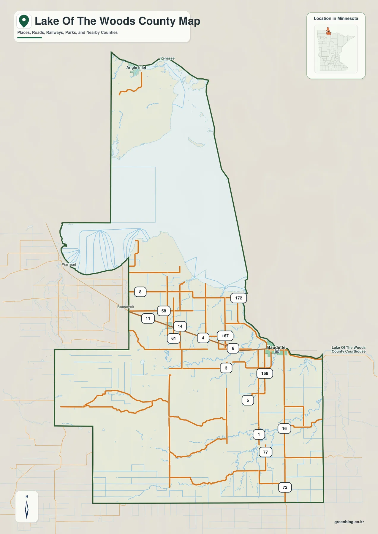
A cluster of numbered routes surrounds the Baudette-Williams corridor. Roads 11, 58, 61, 14, and 4 are visible across the central interior, while 167, 6, 158, and 3 appear closer to Baudette. Farther south, Roads 1, 77, 16, and 72 cross a much more sparsely settled landscape.
The spacing between roads and settlements increases toward the south. Large town labels disappear, while streams and wetlands become more visually important. That pattern is typical of a county where much of the land is rural, forested, wet, or lightly developed rather than organized around a dense chain of towns.
Warroad is labeled outside the western boundary and helps place the county relative to Roseau County. Koochiching County borders the east, while the lake and international boundary dominate the north. The map is designed for orientation, not current road construction, winter conditions, or travel-time estimates.
Baudette and Williams are the two selected city references
The city map highlights only Baudette and Williams. Baudette sits on the eastern side of the southern mainland, while Williams is farther west. A broad rural area separates the two, and both lie far south of the Northwest Angle portion of the county.
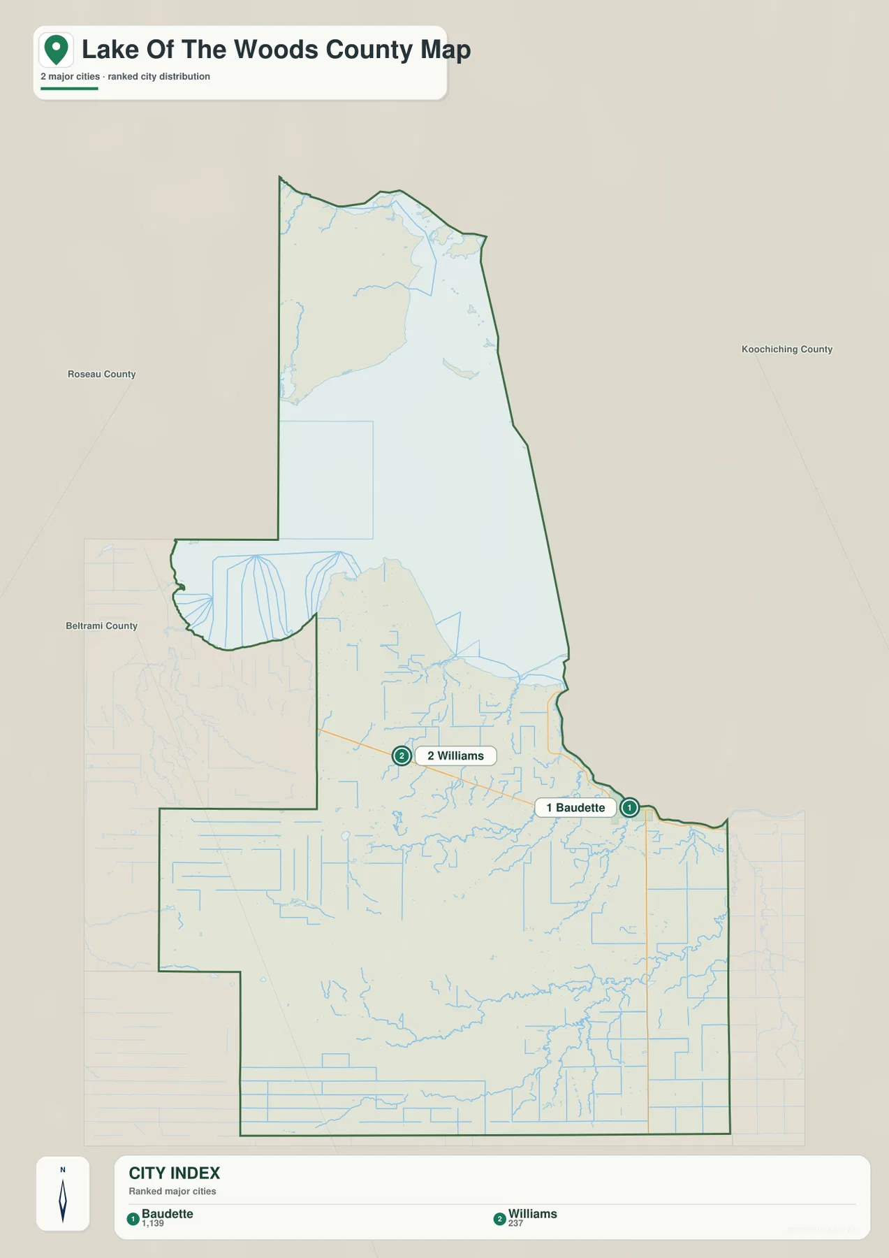
The supplied CITY INDEX lists Baudette at 1,139 and Williams at 237. These should be treated as values embedded in the map rather than as a claim about the latest official population estimates. Their main value is comparative: Baudette is represented as the much larger of the two selected communities.
Roosevelt appears on the general map but is not part of the two-city index. Lake of the Woods County’s official information identifies Baudette as the county seat, which matches the map’s strong emphasis on the city. Williams remains an important western mainland reference, especially when the county is viewed in relation to Warroad and the Roseau County side.
This city map is not a mileage chart. Actual driving between Baudette and Williams depends on the chosen route and current conditions. Use it for relative position, then return to the general county map when road numbers, waterways, and outlying areas matter.
Lake of the Woods separates the Northwest Angle from the mainland
The northern part of the county is its most distinctive feature. Lake of the Woods occupies a huge area between the southern mainland and the Northwest Angle. Angle Inlet and Penasse are labeled near the upper portion of the map, while the water itself fills most of the space between them and the Baudette-Williams side of the county.
Lake of the Woods County’s official history describes the Northwest Angle as one of the county’s defining geographic features. County planning material also explains that the Angle mainland is separated from the rest of Lake of the Woods County by the lake and that highway access commonly passes through Manitoba, Canada. The unusual outline on the map therefore reflects a real geographic separation, not just a cartographic design.
Youngs Bay is labeled near the far north, while Zippel Bay appears along the southern lake shore. These bays help orient the enormous open-water area and make the county’s shoreline geography easier to understand. In the north, the lake itself is a more useful reference than the road grid.
Winter Road, Baudette, and Rapid rivers drain the southern interior
South of Lake of the Woods, the water map highlights Winter Road River, Baudette River, and Rapid River. Winter Road River crosses the north-central mainland, Baudette River runs toward the eastern side near Baudette, and Rapid River forms one of the strongest channels in the southeast.
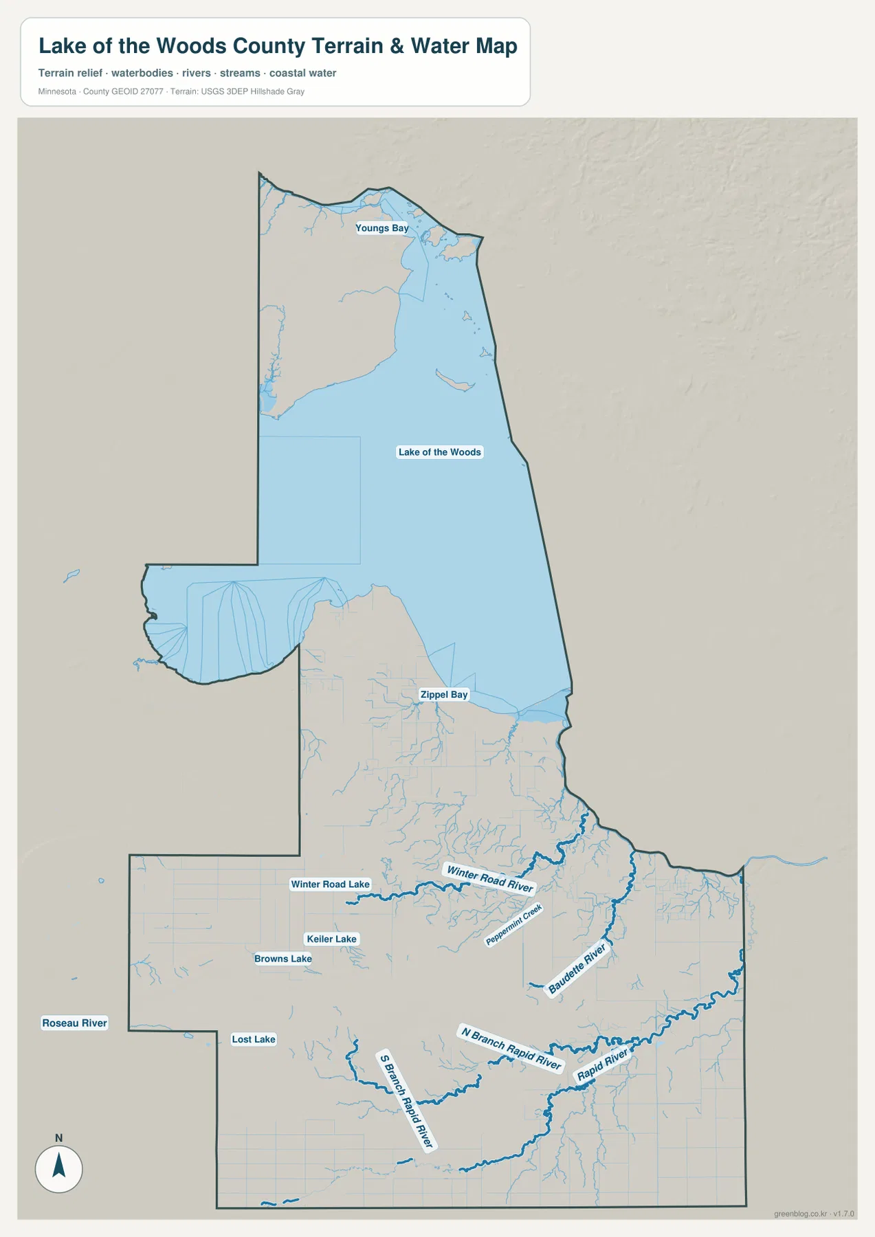
North Branch Rapid River and South Branch Rapid River are both labeled, showing how water from a broad southern area converges toward the larger channel. Roseau River appears beyond the western county side, and Peppermint Creek provides another named reference in the center-east. Numerous smaller channels show that the mainland is far more water-rich than the road map suggests.
Winter Road Lake, Keiler Lake, Browns Lake, and Lost Lake provide smaller inland landmarks. Their scale is modest beside Lake of the Woods, but they help show where local depressions and wet areas occur across the southern county. Winter Road Lake is especially easy to connect with the nearby Winter Road River.
Minnesota DNR manages Lake of the Woods and the Rainy River system as major fisheries waters and identifies Lake of the Woods as Minnesota’s largest lake. The map here is for geographic orientation only; it does not provide water depth, ice safety, boating rules, flood zones, or current fishing regulations.
A 315–401 meter range from southwest uplands to lake lowlands
The supplied elevation map reports an actual range of about 315 to 401 meters, with a mean near 347 meters. The strongest brown high ground occupies the southwest, while greens dominate the Lake of the Woods side and much of the eastern county. This southwest-to-northeast drop is the clearest large-scale relief pattern.
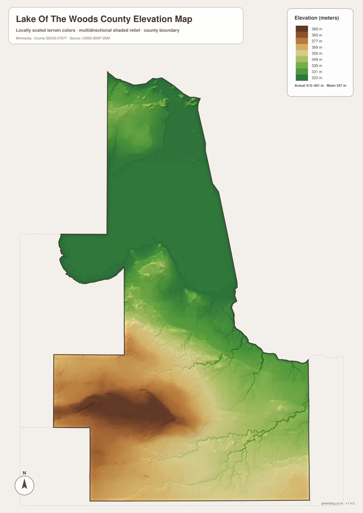
The southwest contains the broadest and darkest high area. From that upland, terrain steps down toward the east and northeast, while Rapid River and its tributaries occupy lower corridors. The strong brown patch makes it clear that the southern mainland is not uniformly flat.
A smaller elevated area appears in the central interior, but it is much less extensive than the southwest upland. North of it, terrain becomes increasingly low toward Lake of the Woods. Lake of the Woods County’s official hazard-mitigation plan describes the southwest as roughly 200 feet higher than areas near the lake, which matches the broad contrast visible in the supplied map.
Baudette and the eastern edge lie within lower terrain crossed by many streams. Rapid River and Baudette River align with narrow green valleys on the elevation surface. The Northwest Angle is also mostly low, although small higher patches appear near the far northern mainland.
This elevation map is appropriate for county-scale comparison, not survey or engineering work. It should not be used for exact building elevations, road grades, drainage design, or parcel-level contour decisions. Detailed USGS 3D Elevation Program data or professional survey information are better sources when precision matters.
Baudette and the Northwest Angle represent two very different county settings
Baudette is the county’s principal mainland community and administrative center. Roads converge around it, the Baudette River is nearby, and access to the south shore of Lake of the Woods and the Rainy River area is relatively direct. The city map also makes Baudette clearly larger than Williams among the two selected communities.
The Northwest Angle has a completely different geographic relationship to the rest of the county. Lake of the Woods separates its mainland from the southern county, and the map labels Angle Inlet and Penasse in the far north. County history repeatedly treats the Northwest Angle as a defining local feature, so it deserves to be considered alongside Baudette rather than as a minor map appendage.
Williams provides a useful third reference on the southern mainland. It sits west of Baudette and closer to the Warroad-Roseau County side. Taken together, Baudette, Williams, and the Northwest Angle show why Lake of the Woods County cannot be understood as a single compact road-and-town district.
Choosing the right view for roads, cities, water, or terrain
Use the general county map when Baudette, Williams, Roosevelt, Angle Inlet, major roads, and the unusual county outline need to appear together. The city map is cleaner when the goal is to compare Baudette and Williams without the full road and water detail. The Northwest Angle’s separation is easiest to understand on the general map.
The water map is the better choice for Lake of the Woods, Zippel Bay, Winter Road River, Baudette River, Rapid River, and smaller inland lakes. Pair it with the elevation view when the goal is to explain why the southwest is higher and why lake-side and eastern river terrain is lower.
For printing or image editing, the original JPG files in the ZIP provide more resolution than the WebP previews embedded in this article. Each JPG measures 2572 by 3638 pixels, and the archive contains the county, city, water, and elevation maps.
Official county GIS, history, DNR, and federal sources
Lake of the Woods County maintains an official Maps page and IT/GIS program with links to the county plat book, Public Land Survey maps, Minnesota DNR mapping, and an interactive GIS map. Parcel, property, legal-boundary, and other administrative questions should rely on those current county tools rather than on a general overview map.
The county’s Local History page provides useful background on the Northwest Angle and the development of Baudette and Williams. Minnesota DNR is the appropriate state source for Lake of the Woods and Rainy River management, while U.S. Census Bureau TIGER/Line, USGS National Hydrography, and the USGS 3D Elevation Program support more detailed boundary, water, and elevation work.
Frequently Asked Questions
Why does the Northwest Angle appear separated from the county mainland?
The Northwest Angle mainland is separated from the southern part of Lake of the Woods County by Lake of the Woods. County planning information notes that highway travel to Angle Inlet commonly passes through Manitoba, Canada. The long northern land section on the map represents this real geographic separation.
Why does the city map show only Baudette and Williams?
The supplied city map selects two major communities and lists Baudette at 1,139 and Williams at 237 in its CITY INDEX. Roosevelt appears on the general county map but is not included in this two-city ranking.
Where is the highest terrain in Lake of the Woods County?
The supplied elevation map shows a range of about 315–401 meters with a mean near 347 meters. The southwest is highest overall, while Lake of the Woods, Baudette, and many eastern river corridors occupy lower terrain. Exact site elevations require detailed USGS or survey data.
Map File Information
Download the original high-resolution JPG versions of the Lake of the Woods County maps shown on this page in one ZIP file.
- Included Files: county map, city map, water map, elevation map
- Printable Size: each JPG is 2572 × 3638 px
- File Type: ZIP containing 4 JPG files
Related Maps
Sources and references
- Lake of the Woods County Maps – official county mapping, plat book, survey, and interactive GIS resources
- Lake of the Woods County Local History – Northwest Angle, Baudette, Williams, and county history
- Minnesota DNR Lake of the Woods – official Lake of the Woods and Rainy River management information
- U.S. Census Bureau TIGER/Line Shapefiles – boundary, road, and place data
- USGS National Hydrography – river, stream, and water data
- USGS 3D Elevation Program – elevation data and products
Green Map creates custom-edited map images using open geographic data sources such as geoBoundaries, Natural Earth, OpenStreetMap, and government open data. These maps are edited visual materials, not raw data files, and are provided for education, documents, presentations, and graphic reference.