Jefferson County lies along Nebraska’s southern state line, with Fairbury near the center of its road network and the Little Blue River cutting southeast through rolling farm country. U.S. 136 reaches Fairbury from the west, while Nebraska Highways 15 and 8 connect the county seat with northern and southern parts of the county. This page compares the locations of Fairbury, Plymouth, Daykin, Diller, Endicott, and Jansen, the major roads, the Little Blue River drainage, and an elevation range of about 373 to 493 meters. The four original high-resolution JPG maps can also be downloaded together in a ZIP archive for printing or detailed viewing. High-resolution map files are available for download in the section below.
Jefferson County’s official website describes the county as roughly 573 square miles and confirms Fairbury as the county seat. The maps show why the area is easier to understand through both roads and terrain: higher ground occupies much of the west and southwest, while the Little Blue River creates a lower corridor through the middle and toward the Kansas border. Smaller streams cut into the uplands from several directions, producing a landscape of low rolling hills rather than one flat agricultural surface.
Table of Contents
Fairbury ties U.S. 136 to Highways 15 and 8 near the Little Blue River
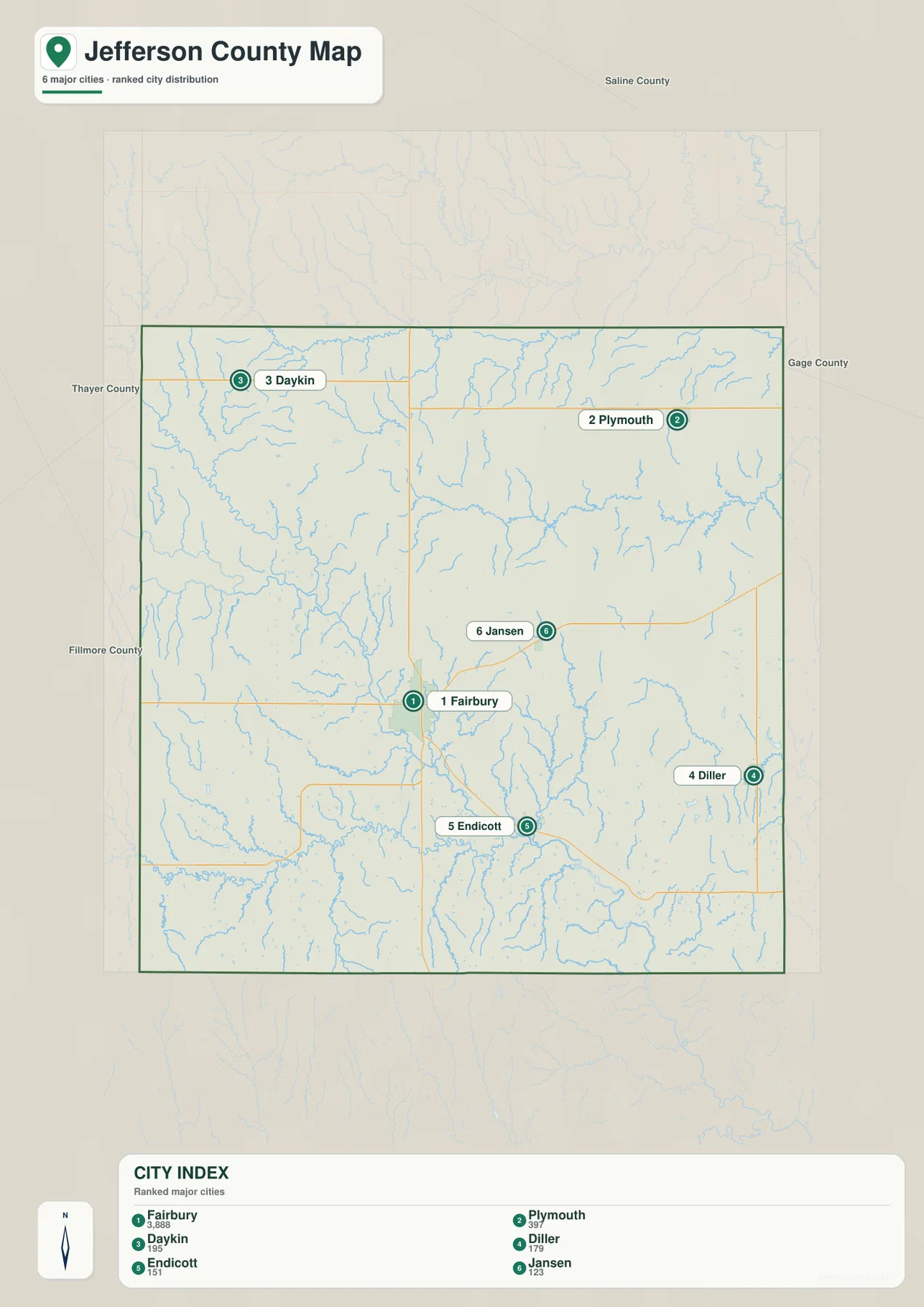
Fairbury is the clearest starting point on the general county map. U.S. 136 approaches from the west and reaches the city, while Nebraska Highway 15 runs north–south through the same area. Highway 8 leaves Fairbury toward the southeast, connecting the county seat with the Endicott and Steele City side of the county. City of Fairbury material also identifies Highways 15 and 8 and U.S. 136 as the principal routes at the community, making Fairbury a practical anchor for understanding Jefferson County’s transportation pattern.
The smaller communities form a wide ring around that center. Daykin sits to the northwest, while Plymouth is in the northeast near Highway 4. Jansen lies east of Fairbury, followed farther east by Harbine and Diller; Endicott and Steele City occupy the southeastern side. Reynolds is separated from the main eastern cluster and lies toward the southwest. Because the towns are spread across several directions rather than lined up on a single corridor, the road that matters most changes depending on which community a traveler is trying to reach.
The outer boundary adds another strong reference. Saline County is to the north, Gage County lies to the east, and Thayer County is on the western side. Jefferson County’s southern edge is also Nebraska’s state line with Kansas, which makes the lower border easier to recognize than an ordinary county line. Fillmore County lies near the northwest side of the broader area. Roads and streams continue across all of these boundaries, so the county outline is most useful when it is paired with Fairbury, the Little Blue River, and the Kansas line.
The six-city ranking makes Fairbury’s size advantage easy to see
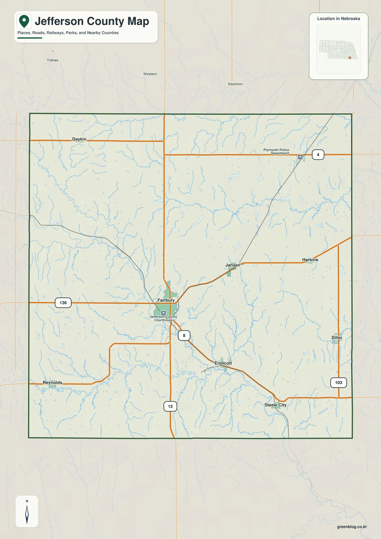
The city-distribution map identifies six major communities in Jefferson County. Fairbury ranks first, followed by Plymouth, Daykin, Diller, Endicott, and Jansen. The ranking belongs to the supplied map and should be treated as a visual index rather than a current official population table. Its strongest value is geographic: Fairbury clearly dominates the county’s settlement pattern, while the other five communities are much smaller and scattered across the northern, eastern, and southeastern parts of the county.
The printed city index lists Fairbury at 3,888, Plymouth at 397, Daykin at 195, Diller at 179, Endicott at 151, and Jansen at 123. Anyone who needs current population estimates should consult a recent Census release or county source, but the map values still show the large gap between Fairbury and the other ranked places. Jefferson County therefore looks less like a continuous urban area and more like one main town surrounded by several small communities separated by farmland, tributaries, and local roads.
Each of those towns helps locate a different part of the county. Plymouth and Daykin mark the northern half, Diller gives a reference near the eastern boundary and Highway 103, and Jansen sits comparatively close to Fairbury on the east side. Endicott helps orient the lower Little Blue River corridor. Smaller places such as Harbine, Reynolds, and Steele City appear on the general county map even though they are not included in the six-city ranking, so switching between the two maps provides a fuller picture.
The Little Blue River gathers creeks from the western hills and eastern farm country
The Little Blue River is the most important natural line on the terrain-and-water map. It enters Jefferson County from the northwest, passes close to Fairbury, then bends southeast toward the Kansas state line. The elevation map shows the same route as a dark green low corridor, making the relationship between water and terrain especially clear. Because Fairbury sits beside this valley, the county seat provides an easy link between the road map and the physical landscape.
Several named tributaries feed the river system. Little Sandy Creek descends from the northwest and joins the main valley, while Cub Creek crosses a long stretch of the north-central county. Rock Creek and Elm Creek drain parts of the east-central area, and Big Indian Creek runs down the eastern side. Buckley Creek and Rose Creek are visible in the southwest, along with many smaller unnamed channels that follow shallow valleys toward the Little Blue River.
The drainage pattern shows why Jefferson County should not be pictured as a perfectly flat block of farmland. Numerous short streams cut across rolling uplands before reaching the larger river. South Fork Swan Creek appears near the northern side, while the denser network south and west of Fairbury reveals repeated low valleys between higher ridges. When roads and town labels are added back mentally, it becomes easier to see how communities developed within a landscape shaped by both agriculture and drainage.
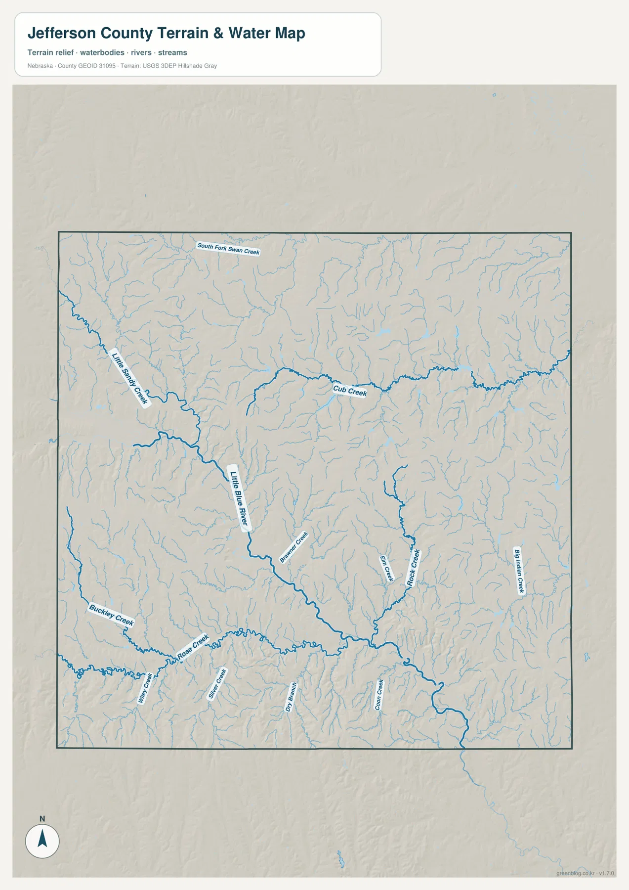
This water map is intended for geographic reference rather than flood decisions, navigation, property boundaries, or real-time river conditions. A stream shown on the map does not indicate current flow, safe access, bridge status, or flood risk. For those questions, current USGS data and local emergency or planning information should be used. Here, the map is most useful for understanding which parts of the county drain toward the Little Blue River and how the tributary valleys divide the uplands.
A 373–493 meter elevation range separates western uplands from the river lowlands
The supplied elevation map gives an actual county-wide range of roughly 373 to 493 meters, with a mean near 436 meters. Brown and orange colors cover much of the west and southwest, while green follows the Little Blue River through the central and southeastern parts of the county. The total difference is about 120 meters. That is modest compared with mountainous counties, but it is large enough to produce a clear contrast between broad uplands and the lower river corridor.
The Fairbury area illustrates the pattern well. Higher tan and brown ground rises to the west and northwest, then drops toward the Little Blue River valley beside the city. Southeast of Fairbury, the river remains in a low green corridor as it approaches the Endicott and Steele City side of the county. Northeastern Jefferson County is generally lower than the western uplands, but its surface is still broken by many small ridges and tributary valleys rather than forming one smooth plain.
Higher terrain also reappears near parts of the southern and southwestern edge. Small creeks cut into those uplands and create narrow green channels that connect back toward the main river system. This is why a simple statement that the county slopes from west to east is incomplete. A better description is that broad western and southwestern uplands are dissected by many creeks, while the Little Blue River creates the strongest low corridor through the center and toward the southeast.
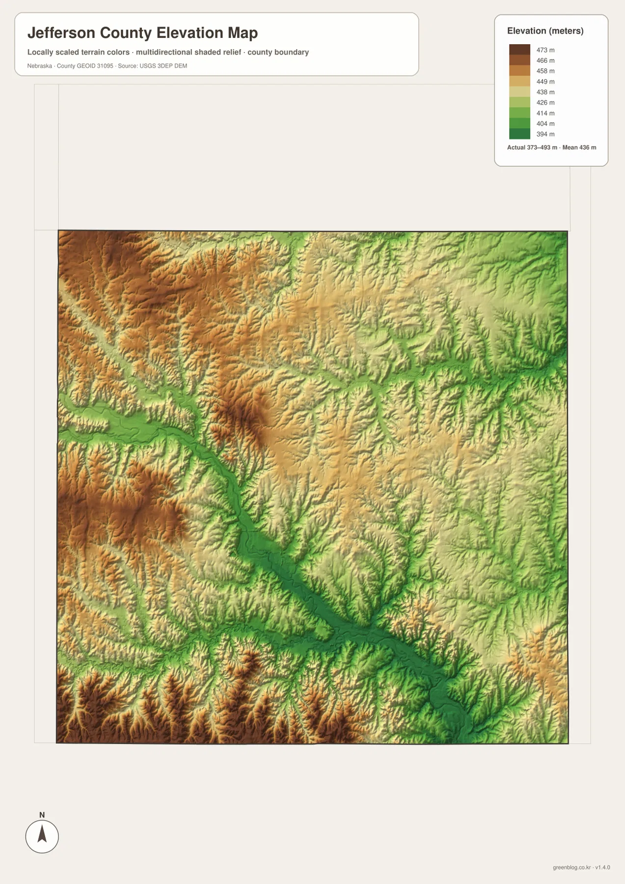
The elevation surface is generalized for county-scale comparison. It is not suitable as survey-grade elevation for a parcel, building site, drainage design, road grade, or engineering project. Those uses require current high-resolution datasets such as the USGS 3D Elevation Program and, where necessary, professional field measurements. For regional study, however, the color ramp makes the relationship between Fairbury, the river valley, and the surrounding hills straightforward to see.
The Kansas border and river valley divide southern Jefferson County into distinct settings
Jefferson County’s position on the Nebraska–Kansas line gives the southern part of the map an unusually clear edge. Highway 15 heads south from Fairbury toward the state line, while Highway 8 angles southeast toward Endicott and Steele City. Diller sits near the eastern side and is linked to Highway 103. These routes do not converge on one southern center; instead, they spread through a lightly populated agricultural area where the river valley and rolling uplands are often better location guides than town density.
The Little Blue River adds a second frame for the south. After passing Fairbury, it bends southeast through the lower terrain, while higher country remains to the southwest around the Reynolds side of the county. Endicott and Steele City are much closer to the river corridor. Even within the same southern half of Jefferson County, the western uplands and the southeastern lowlands have noticeably different relief, which becomes obvious when the county and elevation maps are compared.
Fairbury’s local history also fits this geography. City material describes the community’s beginnings near a sawmill on the Little Blue River in 1868 and notes the importance of later railroad development. On today’s maps, the same area remains where a major river valley and several important highways come together. The county seat is therefore not simply a dot near the middle of Jefferson County; its location reflects a long-standing connection among water, transportation, and settlement.
Choose the sheet by whether you need roads, communities, drainage, or relief
The general county map is the best first choice for Fairbury, the smaller towns, U.S. 136, Highways 15, 8, 4, and 103, and the county boundary. It is particularly useful when comparing the northern locations of Plymouth and Daykin with the eastern and southeastern positions of Diller and Endicott. The city-distribution map removes much of that background and focuses on the six ranked communities, making the large difference between Fairbury and the smaller towns easier to see.
For physical geography, the terrain-and-water map provides much more detail. The Little Blue River can be followed together with Little Sandy Creek, Cub Creek, Rock Creek, Elm Creek, Big Indian Creek, and other tributaries. The elevation map answers where the land is higher or lower, placing the western uplands and river corridor in immediate contrast. Viewing those two sheets side by side shows why the river follows its particular route and why the strongest lowland band runs through Fairbury toward the southeast.
A useful sequence for schoolwork or regional comparison is to locate towns and highways first, then trace the same area on the water map, and finally compare elevation. The WebP images on the page are quick previews; the original JPG files are better when labels need to be enlarged or the maps need to be printed. These are general-reference products, so legal boundaries, flood determinations, live road conditions, surveying, and engineering work should use the latest authoritative source for the specific task.
Frequently Asked Questions
Where is the Jefferson County seat?
Fairbury is the county seat. Jefferson County’s official website identifies Fairbury as the seat, and the maps show why it is an effective geographic reference: U.S. 136 and Highways 15 and 8 meet in the same area, while the Little Blue River passes close to the city.
Which part of Jefferson County does the Little Blue River cross?
The river enters from the northwest, passes the Fairbury area, and then bends southeast toward Kansas. Little Sandy Creek and several other tributaries join the system, and the elevation map shows the main river as one of the county’s lowest green corridors.
Can the 373–493 meter elevation range be used for surveying or construction?
No. The range is a generalized county-scale summary that is useful for comparing the western uplands with the lower Little Blue River valley. Parcel surveys, construction, drainage design, and road engineering require current detailed elevation data and professional measurements rather than this regional reference map.
Map File Information
The county, city-distribution, terrain-and-water, and elevation maps described on this page are available together in one ZIP file. It contains four original high-resolution JPG maps suitable for printing and detailed viewing.
- Included Files: County map, city-distribution map, terrain-and-water map, elevation map
- File Type: JPG files in a ZIP archive
Related Maps
Sources and references
These official and public sources provide additional context for Jefferson County government, Fairbury history, administrative boundaries, waterways, and elevation. The maps on this page are simplified for readable regional reference, so legal, engineering, and current-condition decisions should be checked against the original authoritative datasets and notices.
- Jefferson County, Nebraska official website – county overview and government information
- City of Fairbury official website – community information and public resources
- U.S. Census Bureau TIGER/Line – administrative boundary and geographic reference data
- USGS National Hydrography – river and stream data
- USGS 3D Elevation Program – elevation data
Green Map creates custom-edited map images using open geographic data sources such as geoBoundaries, Natural Earth, OpenStreetMap, and government open data. These maps are edited visual materials, not raw data files, and are provided for education, documents, presentations, and graphic reference.