Stevens County occupies the far southwestern High Plains of Kansas, with Hugoton serving as the clear urban and administrative center and Moscow forming a much smaller community to the northeast. US 56 and K-25 provide the county’s main highway references. The Cimarron River clips the northwestern part of the county, cutting a deep valley into otherwise broad upland terrain. High-resolution map files are available for download in the section below.
This guide follows Hugoton, Moscow, the main highway network, the Cimarron River, and elevation changes from about 867 to 1,016 meters. WebP previews are available for quick viewing, and the matching high-resolution JPG files can be downloaded together in one ZIP for printing, classroom work, or offline reference.
Table of Contents
Hugoton anchors the county at the US 56 and K-25 highway junction
Hugoton lies slightly south of the county center and is the strongest road reference in Stevens County. US 56 provides the principal east–west route, while K-25 runs north–south through the county. Kansas Department of Transportation records identify both routes as important highway corridors in Stevens County.
The official Stevens County website places county government and the courthouse at 200 E. 6th in Hugoton, and the Kansas Historical Society identifies Hugoton as the county seat. On the map, the city also contains the densest concentration of streets, rail lines, and local roads.
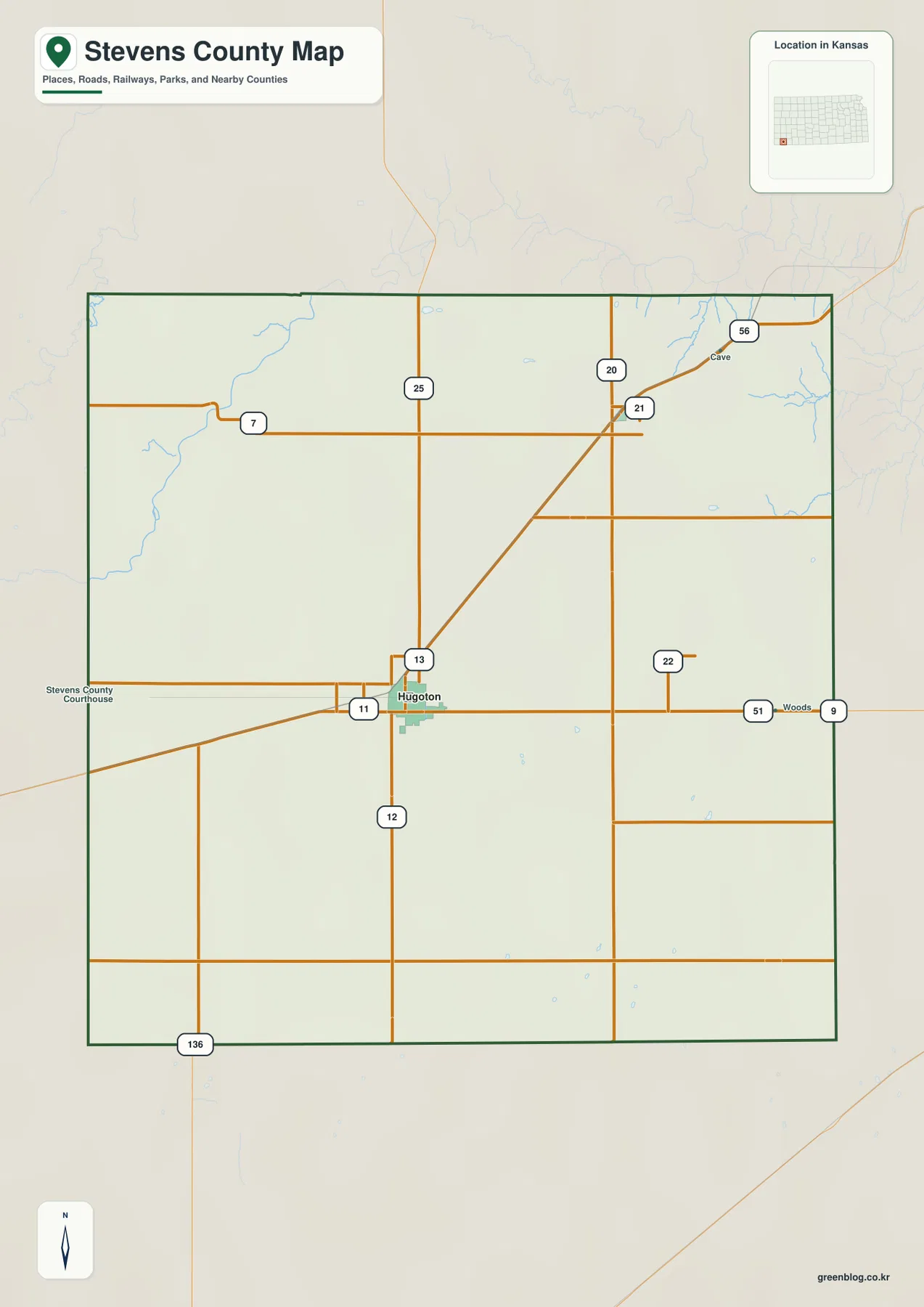
Moscow lies in the northeastern part of the county, separated from Hugoton by broad agricultural land. Woodsdale survives as a map label near the eastern side and provides a direct reminder of the county’s nineteenth-century seat rivalry. In a county with few towns, road numbers and historic place names are especially useful for orientation.
The city panel contains only Hugoton and Moscow
The supplied city panel lists Hugoton at 3,974 and Moscow at 180. These are map index values rather than current official population estimates, but they show the dramatic difference in scale between the county seat and the smaller northeastern community.
Hugoton occupies a broad street grid and transportation node, while Moscow is a compact settlement surrounded by rural land. The two places are the only ranked cities in this package, so the county’s urban hierarchy is unusually simple compared with counties that contain several similarly sized towns.
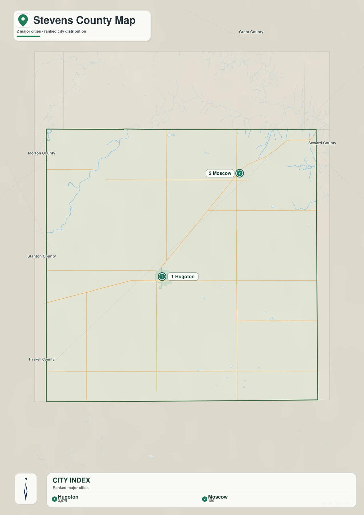
Kansas Historical Society material likewise identifies Hugoton as the county seat and central community. The official population record and the supplied map index are different datasets and should not be used interchangeably, but both reflect Hugoton’s dominant local role.
The Cimarron River cuts a deep valley into the northwestern High Plains
The Cimarron River is the strongest water feature on the terrain map, but it does not cross the entire county. Kansas Geological Survey material describes the river entering northwestern Stevens County before continuing toward Grant County. Even this relatively short reach creates a major break in the otherwise broad upland surface.
Short tributaries descend sharply from the surrounding plateau toward the river. Away from the northwest corner, the surface drainage network becomes much sparser, and much of central and southern Stevens County appears as open High Plains terrain with only small scattered water features.
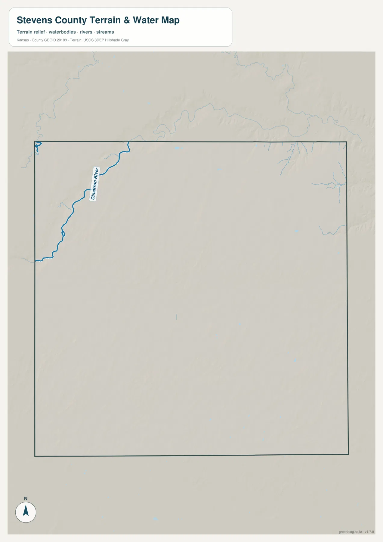
The river’s flow and channel conditions can vary with season and rainfall. This map is intended for geographic reference rather than floodplain, navigation, water-quality, parcel, or legal-access decisions, so current agency information should be used whenever safety or property questions are involved.
Elevation from 867 to 1,016 meters slopes from western uplands toward the east
The elevation surface ranges from about 867 to 1,016 meters, with a mean near 945 meters. Brown and tan high ground dominates much of the west and southwest, while greener lower terrain becomes more common toward the east. The Cimarron River valley creates the sharpest local drop in the northwest.
Hugoton sits on relatively high but gently sloping plains rather than on the river floor. Moscow occupies lower northeastern terrain. The west-to-east gradient is broad and gradual across most of the county, but tributary valleys near the Cimarron create much steeper local relief.
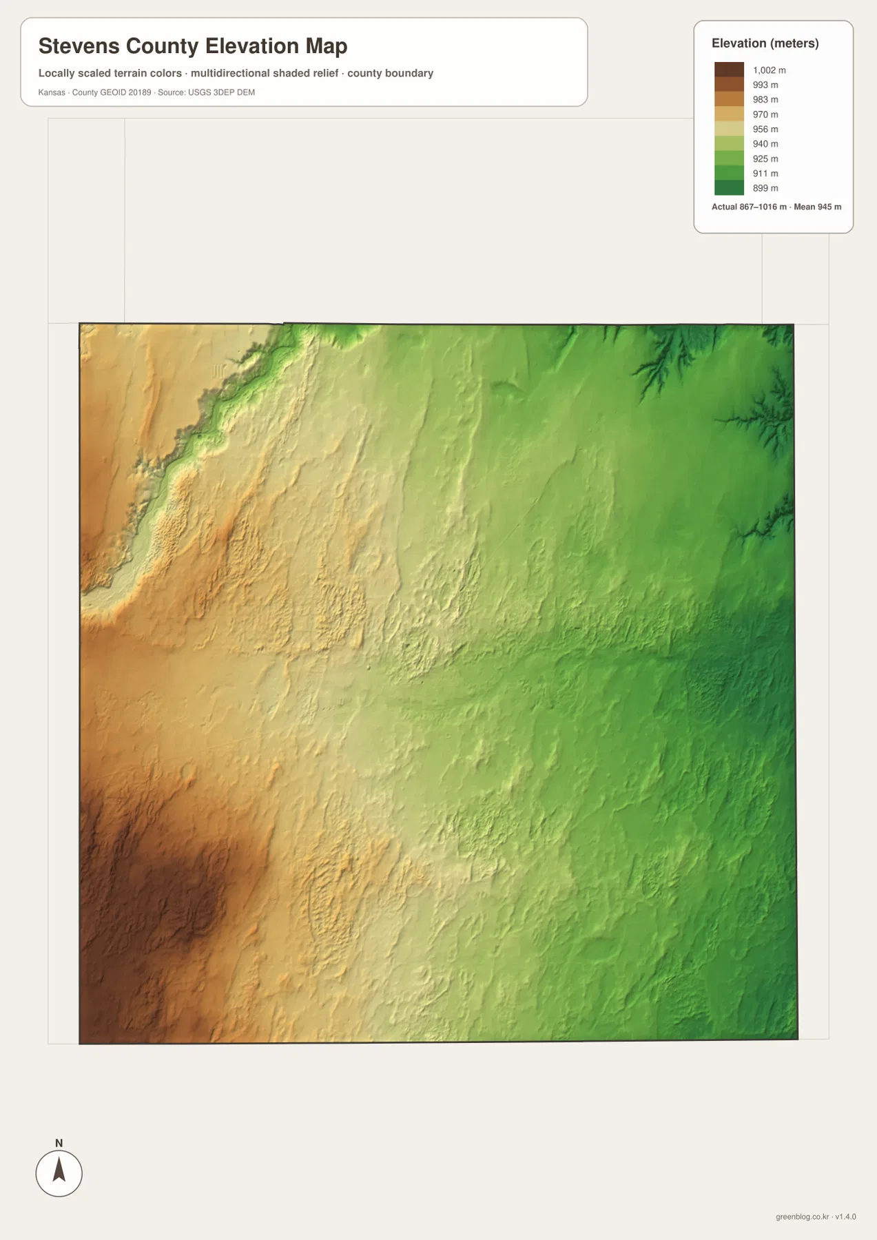
The Kansas Historical Society places Stevens County within the High Plains physiographic region. The relief image fits that description: wide upland surfaces dominate the county, while the river corridor and short tributaries create the most obvious breaks in elevation.
The elevation surface is generalized for county-scale comparison. It is not survey-grade or engineering-grade measurement and should not be used for parcel elevations, construction grades, drainage design, or legal boundary work.
The Hugoton–Woodsdale county-seat fight shaped the county’s early history
The Kansas Historical Society describes an unusually intense county-seat dispute between Hugoton and Woodsdale during the late 1880s and early 1890s. Elections, arrests, political conflict, and violence drew state attention before Hugoton ultimately became the permanent county seat.
Today the contrast on the map is striking. Hugoton remains the county’s administrative and transportation center, while Woodsdale appears only as a small historic place label. The two names therefore connect the modern map directly with one of southwestern Kansas’s best-known county-seat conflicts.
The Hugoton Gas Field transformed the economy after the 1927 discovery
Kansas Geological Survey records place a major 1927 gas discovery southwest of Hugoton in Stevens County. That discovery became central to the development of the Hugoton producing area, followed by pipelines, additional drilling, and large-scale natural-gas production across southwestern Kansas.
The Kansas Historical Society notes that the Hugoton and Panoma fields extend into Stevens County and that Hugoton Field gas contains significant helium. Individual wells are not shown on the supplied county maps, but the gas industry is essential context for understanding why Hugoton became more than a small agricultural service town.
Dust Bowl history adds another layer to the broad plains landscape
The 1930s Dust Bowl hit southwestern Kansas hard, including Stevens County. Kansas Historical Society material records severe dust storms across the region. The county’s broad, sparsely wooded High Plains setting makes that environmental history especially relevant when considering agriculture, wind, and land use.
The modern maps do not reconstruct 1930s conditions, but the combination of open uplands, limited surface drainage, and widely spaced settlements helps explain why drought and soil loss had such far-reaching effects in this part of Kansas.
For posters, classroom prints, or presentation slides, use the original JPG files in the download archive rather than enlarging the web previews. Small road labels, place names, the Cimarron River, and the elevation legend remain clearer at the higher resolution.
Frequently Asked Questions
Why does the city map show only Hugoton and Moscow?
The supplied ranked-city dataset contains two entries for Stevens County: Hugoton at 3,974 and Moscow at 180. Other place names can appear on the general county map, but only these two communities are included in the city ranking panel.
Does the Cimarron River cross all of Stevens County?
No. The river passes through the northwestern part of the county before continuing toward Grant County. Its short county reach still creates the most pronounced river valley on the water and elevation maps.
Can the 867–1,016 meter elevation image be used for surveying?
No. It is a generalized county-scale terrain image for comparing high western plains with lower eastern terrain and the Cimarron River valley. Parcel elevations, engineering grades, drainage design, and legal boundary work require more precise official data and, where needed, professional surveying.
Map File Information
The archive contains the Stevens County, Kansas general county map, city map, terrain-and-water map, and elevation map as original high-resolution JPG files.
- Included Files: Use only the versions confirmed in the article and supplied images
- File Type: Use the confirmed download contents
- Intended Use: Printing, education, presentations, and map-based projects
Related Maps
Sources and references
- Stevens County, Kansas official website — county government and Hugoton courthouse information
- Kansas Historical Society: Stevens County, Kansas — county-seat conflict, High Plains setting, Dust Bowl, and natural-gas history
- Kansas Geological Survey: Hugoton Natural Gas Area of Kansas — 1927 Stevens County discovery and Hugoton Field development
- Kansas Geological Survey: Grant, Haskell, and Stevens County Geography — Cimarron River and High Plains geography
- U.S. Census Bureau TIGER/Line Shapefiles — county boundary and geographic reference data
- USGS 3D Elevation Program — elevation and terrain reference data
Green Map creates custom-edited map images using open geographic data sources such as geoBoundaries, Natural Earth, OpenStreetMap, and government open data. These maps are edited visual materials, not raw data files, and are provided for education, documents, presentations, and graphic reference.