Wright County lies in the Ozark uplands of southern Missouri, with Hartville in the interior and Mansfield, Norwood, and Mountain Grove spread across the southern part of the county. U.S. 60 gives the southern towns an easy east-west reference, while the interior is broken by the Gasconade River headwaters and a dense network of smaller creeks. The maps on this page separate those questions into clear views of county boundaries and roads, city-to-city position, waterways and terrain, and elevation. High-resolution A3 JPG copies are available in the download box for printing or closer inspection.
A useful way to understand the county is to begin with the road map and then compare the same places on the water and elevation sheets. Mountain Grove sits close to the eastern boundary, Mansfield is farther west near U.S. 60, and Hartville is well north of that southern line. Once the creek valleys are added, the county no longer looks like a simple rectangle crossed by roads; the Gasconade system cuts through the upland and helps explain why nearby places may be separated by ridges and winding routes.
Table of Contents
Hartville in the interior and the U.S. 60 towns to the south
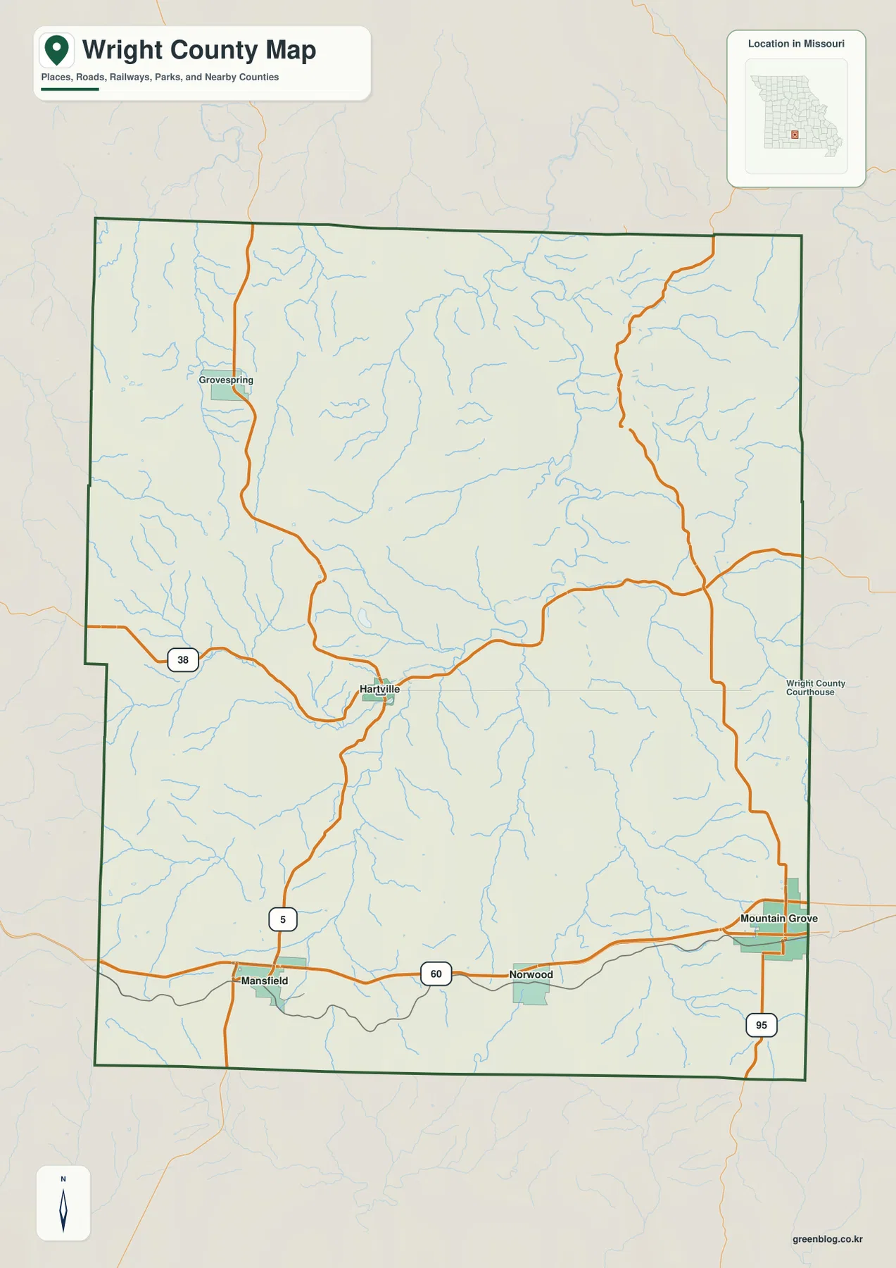
The county overview gives the clearest first look at settlement and transportation. U.S. 60 runs across the southern portion of Wright County, passing Mansfield, Norwood, and Mountain Grove in west-to-east order. Hartville, the county seat, is farther north near the middle of the county rather than directly on that highway. Route 5 links the Mansfield area with Hartville, while Route 38 passes through Hartville and continues across the county. Route 95 appears near Mountain Grove and extends south from the U.S. 60 area.
That arrangement matters because the administrative center and the most obvious east-west highway are not in the same place. A visitor approaching from the south may encounter Mansfield, Norwood, or Mountain Grove before ever reaching Hartville. Mountain Grove is especially close to the eastern county line, whereas Hartville is surrounded by more of Wright County on every side. Grovespring is also labeled in the northwestern part of the map, providing another useful reference away from the U.S. 60 corridor.
The boundary labels help place Wright County in its regional setting. Laclede County lies to the north, Texas County to the east, Douglas County to the south, and Webster County to the west. Those neighboring names are useful when a route continues beyond the county line, because the roads on the map do not stop being relevant at the border. For general orientation, the overview is the best sheet to use before switching to the more specialized water or elevation maps.
Using Mountain Grove as a hub for straight-line distance
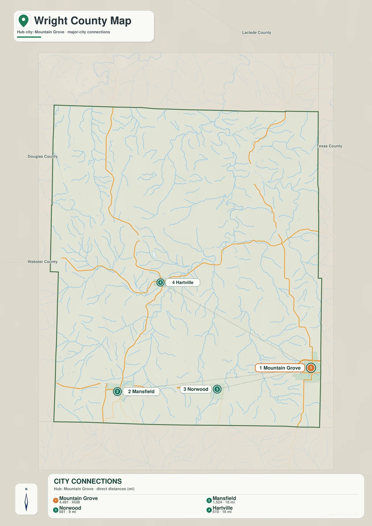
The city-connections map strips away much of the road detail and turns Mountain Grove into a simple reference point. From that hub, Norwood is shown at about 9 miles, Hartville at about 16 miles, and Mansfield at about 18 miles. These values are straight-line distances, not driving distances. They are useful for comparing relative separation and direction, but they should not be used to estimate mileage on a route without checking an actual road service.
The pattern is easy to understand visually. Norwood is west of Mountain Grove and remains on the southern line of settlements, while Mansfield is farther west. Hartville is different: it lies north of the southern towns, so its connection from Mountain Grove cuts diagonally into the county interior. Two destinations can therefore have similar straight-line distances while requiring very different road choices. The map is most helpful when the question is simply, “Which town is closer, and in what direction?”
County-edge position also becomes more obvious on this sheet. Mountain Grove sits almost against the eastern boundary, and Mansfield occupies the southwestern part of the county. Hartville is more centrally placed, which helps explain its role as the county seat even though it is not on U.S. 60. If a trip involves several Wright County communities, this simplified view is a good planning aid before turning to current navigation for exact roads, travel times, closures, or construction.
Gasconade headwaters among branching Ozark creek valleys
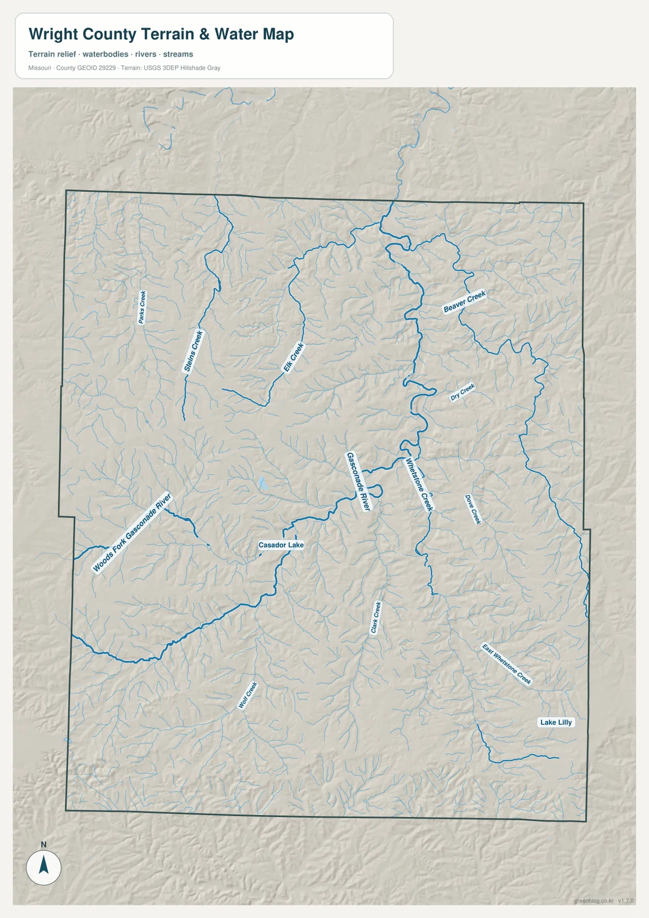
The terrain-and-water map changes the emphasis from roads to drainage. The Gasconade River and Woods Fork Gasconade River are prominent in the western and central portions of the county, while Whetstone Creek forms another long north-south feature farther east. Beaver Creek is labeled in the northeastern area, with Dry Creek and Dove Creek nearby. Instead of one dominant channel occupying the whole county, Wright County contains many branching streams separated by narrow uplands and ridges.
Several smaller names add detail to that picture. Elk Creek and Spring Creek appear toward the northwestern half of the county, while Clifty Creek and East Whetstone Creek are labeled farther south. Casador Lake appears near the west-central part of the map, and Lake Lilly is marked close to the southeastern side. These smaller features are useful landmarks when the main river name alone is not enough to locate a valley or nearby road.
The shaded terrain behind the waterways helps explain why the channels bend and branch. Major creeks occupy lower corridors, and the surrounding land rises into irregular hills between them. Around the Gasconade headwaters and Whetstone Creek, the relationship is especially clear: the named channel follows a low valley while higher ground stands on both sides. The water map therefore works best as a location and terrain reference rather than as a list of river names.
This sheet should not be treated as a flood map or a legal definition of a stream boundary. It does not establish whether a property is inside a flood zone, how far water may spread during a storm, or where a parcel line lies. For those decisions, use the appropriate flood, parcel, engineering, or survey source. Here, the purpose is to show the county’s named waterways and the landforms that surround them.
From 302 to 531 meters: ridges rising above the creek bottoms
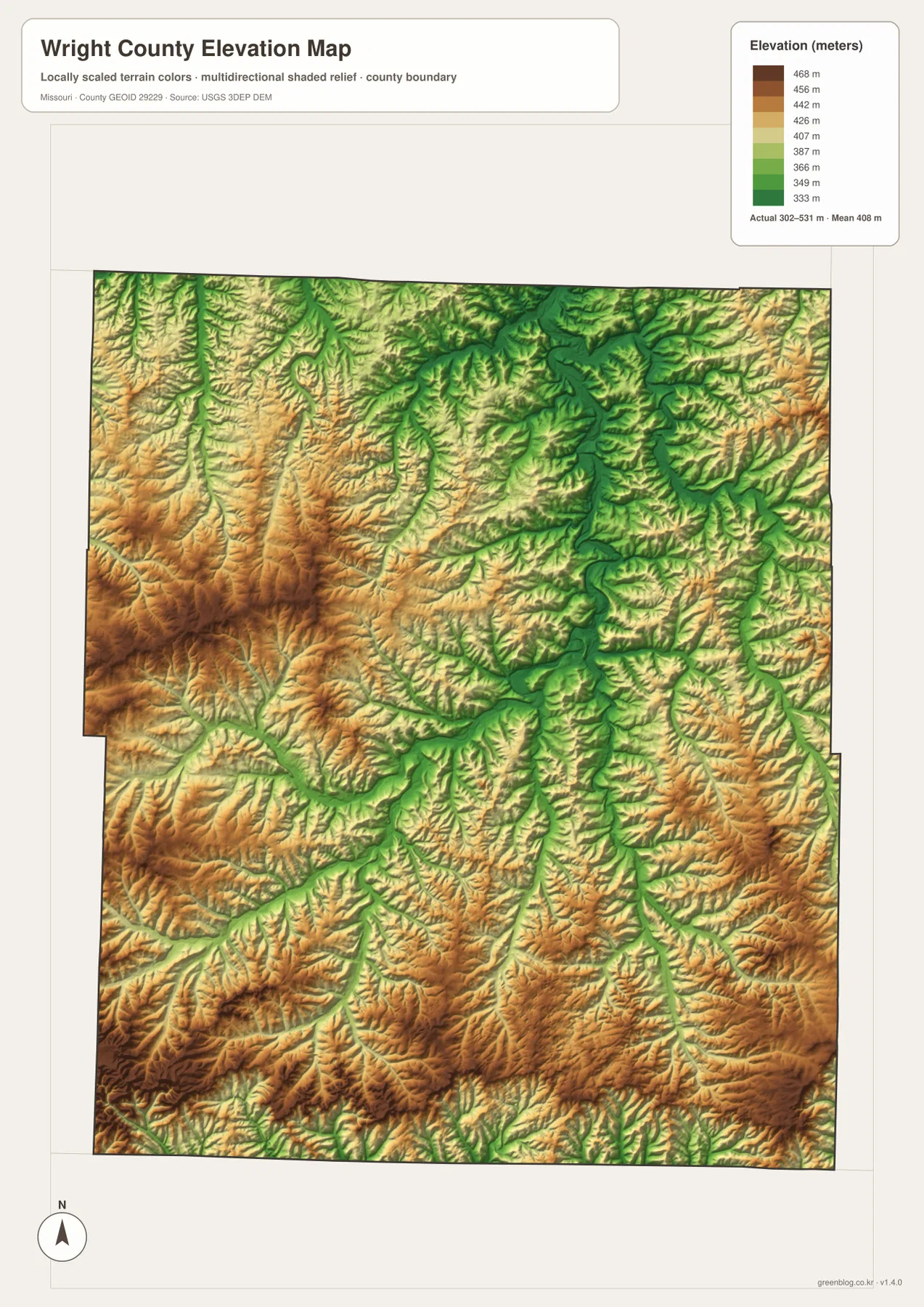
The elevation map reports an actual county range of about 302 to 531 meters, with a mean of roughly 408 meters. Its colors are scaled to Wright County so that lower valleys stand out in green and higher ground appears in tan and brown. This makes the map particularly useful after looking at the water sheet, because many of the long green corridors line up with the places where rivers and creeks have cut into the upland.
Higher terrain is widespread rather than confined to one isolated peak. Broad areas of higher ground appear in the western side and across much of the southern part of the county, but they are repeatedly interrupted by lower creek valleys. The northern and central portions also contain long, branching low areas. As a result, the county looks less like one smooth plateau and more like an upland that has been deeply divided by drainage.
That appearance fits Wright County’s position on the Salem Plateau within the Ozark region. A plateau can still contain pronounced local relief when streams have cut valleys into it, and the elevation map shows exactly that kind of landscape. The difference between a ridge and a nearby creek bottom may be more important to local travel than the countywide elevation average. A short straight-line connection can cross several ups and downs even when both endpoints appear close on the city map.
The elevation surface is intended for regional reference, not engineering or parcel-level measurement. It is useful for comparing the relative height of valleys and uplands, identifying broad terrain differences, and understanding how the creek network fits into the land. It should not replace a survey, site-specific contour data, or a professional slope calculation when precise elevation is required.
Choosing the right Wright County sheet for the question
For a quick county orientation, begin with the overview. It puts Hartville, Mansfield, Norwood, Mountain Grove, major numbered roads, and the county boundary in one place. That is the most practical sheet when the main question is where a town lies or which road crosses a particular part of Wright County. The city-connections map is better when the question is narrower and you simply want to compare the direction and straight-line separation of the principal labeled communities.
Questions about rivers, creeks, or valleys call for the terrain-and-water map. It gives names to the Gasconade River system and several tributaries while showing enough relief to distinguish the valleys around them. If the next question is whether the surrounding land is relatively high or low, move to the elevation sheet and compare the same location. Whetstone Creek and the Gasconade headwaters are good examples of places where the two maps reinforce each other.
The downloadable A3 JPG files are the better choice when you need to zoom in, print a larger copy, or compare labels without relying on the smaller page previews. All four files describe the same county but answer different practical questions, so there is no need to force one map to do everything. For current navigation, road restrictions, legal boundaries, property research, or flood-risk decisions, pair these reference maps with the latest source from the responsible agency.
Frequently Asked Questions
Is the 16-mile Mountain Grove–Hartville figure a driving distance?
No. The city-connections map shows a straight-line distance of about 16 miles between Mountain Grove and Hartville. A road trip follows the available highway and local-road network, so actual mileage and travel time will be different. Use the number to compare the towns’ relative separation, then check a current navigation or road source for a real trip.
Where can I best see the low valleys along the Gasconade River and Whetstone Creek?
Locate the named channels first on the terrain-and-water map, then compare the same areas on the elevation map. Lower ground generally appears in green, while higher ridges and uplands shift toward tan and brown. Together, the two sheets make the relationship between the waterways and the surrounding relief easy to see. They are geographic reference maps, however, not flood-zone or parcel-boundary products.
What is included in the downloadable Wright County archive?
The ZIP contains four high-resolution A3 JPG files: the county overview, the city-connections map, the terrain-and-water map, and the elevation map. The WebP images in the article are smaller previews for convenient browsing, while the JPG copies are better for printing and close viewing. For legal, survey, navigation, or flood decisions, use the relevant current official source in addition to these reference maps.
Map File Information
The Wright County county, city-connections, terrain-and-water, and elevation maps are bundled as high-resolution A3 JPG files.
- Included Files: county map, city-connections map, terrain and water map, elevation map
- File Type: ZIP containing four high-resolution JPG images
Related Maps
Sources and References
Local context for Hartville, neighboring counties, the Salem Plateau setting, and the Gasconade headwaters can be checked through the Wright County Government County History page. Boundary, road, and place-name reference data are available from the U.S. Census Bureau TIGER/Line Shapefiles.
Waterway information can be compared with USGS National Hydrography, and elevation data with the USGS 3D Elevation Program. Additional watershed background is available from the Missouri Department of Conservation Gasconade River watershed page.
Green Map creates custom-edited map images using open geographic data sources such as geoBoundaries, Natural Earth, OpenStreetMap, and government open data. These maps are edited visual materials, not raw data files, and are provided for education, documents, presentations, and graphic reference.