Crawford County in southeastern Kansas is easiest to understand by using Pittsburg and Girard as two different kinds of anchors. Pittsburg is the largest urban area on the supplied maps and occupies the southeastern part of the county, while Girard lies closer to the center and serves as the county seat. Frontenac, Arma, and Franklin extend north from Pittsburg along the eastern side, whereas Cherokee, McCune, Walnut, and Mulberry mark smaller communities around the outer parts of the county. This page uses the supplied general, city, water, and elevation maps to connect those settlements with U.S. 69, U.S. 400, the Cow Creek drainage, Farlington Lake, and the county’s 243–333 meter elevation range. High-resolution JPG versions corresponding to the web maps are available together in the ZIP download box below.
The east side of Crawford County contains the most obvious concentration of cities and major highways. U.S. 69 runs north and south through the Pittsburg–Frontenac–Arma corridor, while U.S. 400 crosses near the southern edge. Girard sits farther west near K-7 and K-47, creating a second orientation point between the eastern urban corridor and the broader rural west. The supplied map also shows K-126 at Pittsburg, K-57 south of the city, and K-171 near the southeast corner. This road pattern makes Crawford County more useful to read as a collection of connected centers than as a place dominated by one single town.
Kansas Historical Society identifies Girard as the county seat and Pittsburg as the county’s largest city. It also places Crawford County within the Cherokee Lowlands and Osage Cuestas, two physical regions that help explain the terrain changes visible in the map set. The county also has a long history of coal mining and zinc smelting, and Pittsburg began as a coal-mining camp in the 1870s. That background matters geographically because the concentration of Pittsburg, Frontenac, Arma, and nearby communities in the southeast is tied to the transportation and industrial history of the area.
Table of Contents
Pittsburg and Girard as the county’s two main reference points
The general county map makes Pittsburg the easiest place to find first. Its urban footprint is the largest on the page, and U.S. 69 runs along the city and continues north through Frontenac, Franklin, and Arma. K-126 crosses the Pittsburg area from east to west, while K-57 continues south from the U.S. 69 corridor. U.S. 400 lies along the southern edge of the county, and K-171 provides another reference near the southeast corner. These highways create a dense orientation framework in the eastern third of Crawford County.
Girard is positioned farther west near the middle of the county. K-7 and K-47 make it easy to identify, with K-47 extending east toward Ringo and Franklin and K-7 continuing north. West and northwest of Girard, settlements and major roads become more widely spaced. Walnut sits near the northwest side, McCune is in the southwest, and large rural areas separate those communities from the eastern urban corridor. This contrast between a denser east and a more open central and western landscape is one of the clearest features of the general map.
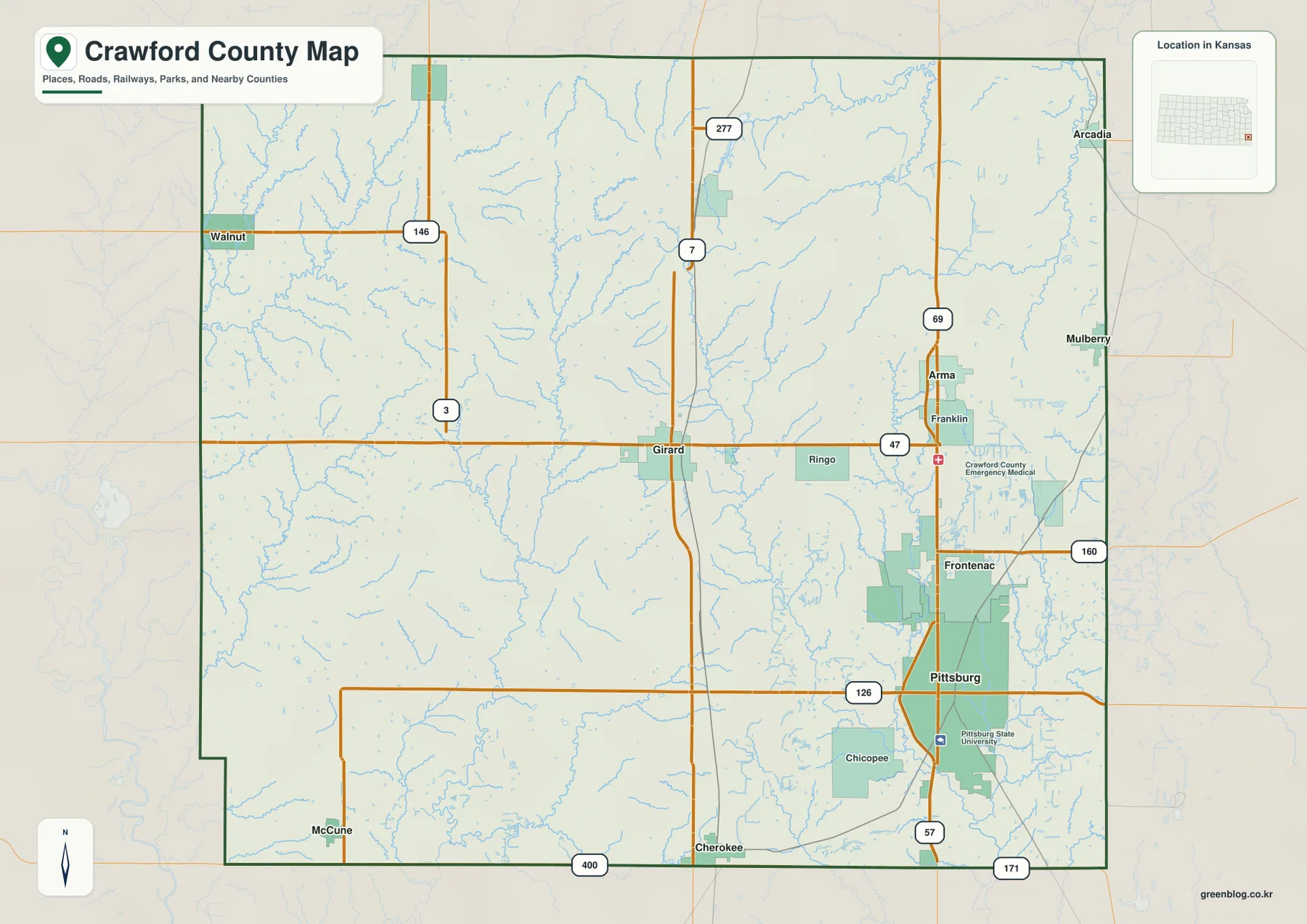
The map also includes Arcadia and Mulberry near the northeast, Cherokee along the southern part of the county, and several smaller place labels that help define the edges of the rural areas. Pittsburg State University is marked in Pittsburg, while a Crawford County emergency medical facility is labeled near the U.S. 69 corridor north of the city. These landmarks reinforce how much of the county’s urban activity is concentrated in the east even though county government remains centered in Girard.
A city pattern concentrated along the eastern side
The city map simplifies the roads and emphasizes the relative positions of six major communities. Its city index ranks Pittsburg first, followed by Frontenac and Girard, with Arma, Cherokee, and Mulberry completing the displayed set. Pittsburg and Frontenac sit very close together, creating a compact urban cluster in the southeast. Arma lies farther north, while Mulberry is close to the northeast edge. Girard is separated from that cluster by a broader rural zone, and Cherokee marks the southern interior.
This arrangement shows why county administration and the largest population center are not in the same place. Girard is the county seat, but Pittsburg is visibly the larger city and functions as a major educational, commercial, and service center. When explaining the county, it is useful to keep both roles in view. Girard gives the administrative center and a central geographic reference, while Pittsburg explains the dominant urban pattern and the U.S. 69 corridor.
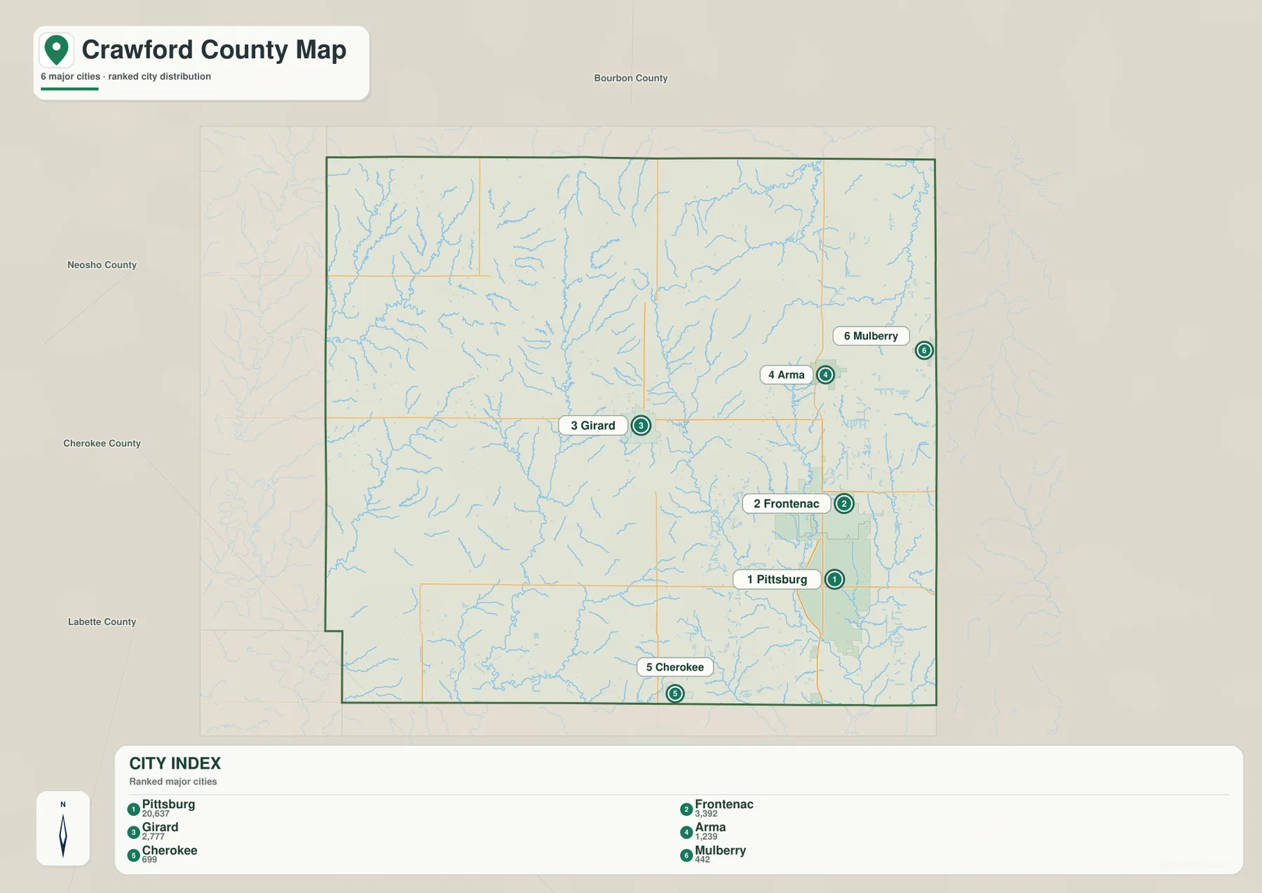
The population figures shown in the supplied city index should be treated as values attached to that map rather than assumed to be current estimates. Current demographic work should use the latest U.S. Census Bureau data or an official city source. For location teaching, travel orientation, and county introductions, however, the city map is valuable because it removes secondary roads and makes the east-side concentration immediately visible.
Cow Creek, Lightning Creek, and the northern lakes
The terrain and water map reveals a dense branching drainage network that is much less obvious on the city view. Cow Creek follows the eastern side of the county, and First Cow Creek and Second Cow Creek run south through the interior east. Bone Creek and Dry Branch add smaller channels in the northeastern area. Together they show that the Pittsburg–Frontenac side of the county is crossed by numerous low corridors even though the general road map visually emphasizes highways and urban areas.
Farther west, Lightning Creek, Hickory Creek, Walnut Creek, and Little Walnut Creek provide the main labeled references. Lightning Creek runs through the central and southern parts of the county, while Hickory Creek lies farther southwest. Walnut Creek and Little Walnut Creek are visible toward the northwest. Farlington Lake and Frisco Lake appear in the northern part of the map, giving useful waterbody landmarks in a county otherwise dominated by narrow stream valleys rather than large lakes.
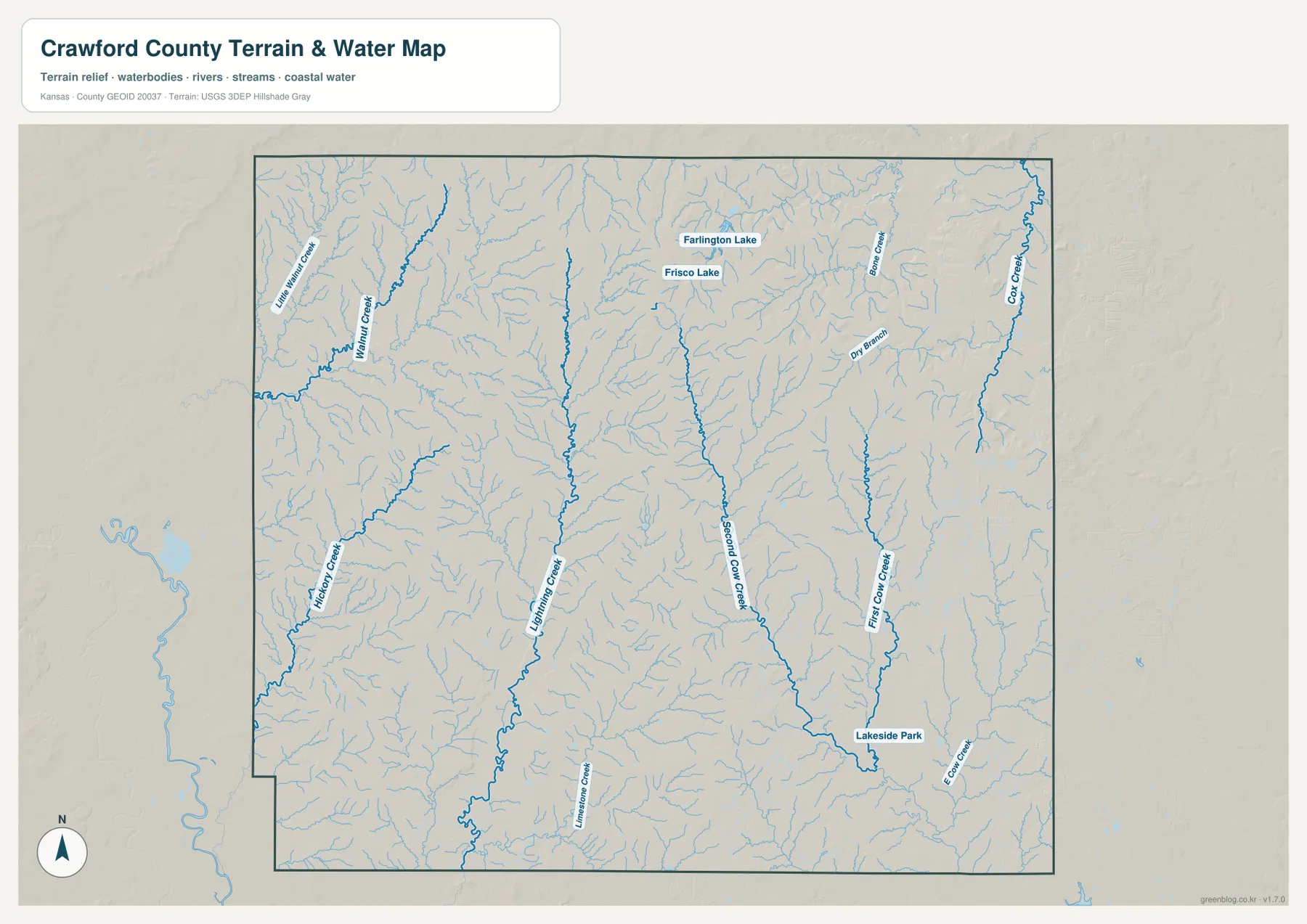
The water network does not form one simple straight corridor. Streams descend through multiple valleys and divide the uplands into long ridges. This becomes much clearer when the water map is compared with the elevation surface. Many of the green low-elevation strips line up with the labeled creeks. The map is not a real-time flood, water-quality, or streamflow product, so current conditions should be checked through USGS or another responsible agency when those details matter.
A 243–333 meter surface cut by narrow valleys
The elevation map gives an actual county range of approximately 243 to 333 meters and a mean elevation of about 287 meters. The highest brown and dark orange areas occur across the north and north-central uplands, with additional elevated ridges in the northwest. Lower green terrain becomes more extensive toward the south and east and follows several of the same valleys highlighted on the water map. Although the overall vertical range is about 90 meters, the close spacing of ridges and creeks creates a strongly textured surface.
The northeastern portion contains elevated ground next to lower eastern valleys, while the Pittsburg area in the southeast appears comparatively low and gentle. Central Crawford County has long north–south ridges separated by drainage corridors, and the west contains a similar mixture of upland and lower creek valleys. Lightning Creek, Second Cow Creek, Hickory Creek, and Walnut Creek help explain why the relief breaks into repeated bands rather than forming one isolated hill or escarpment.
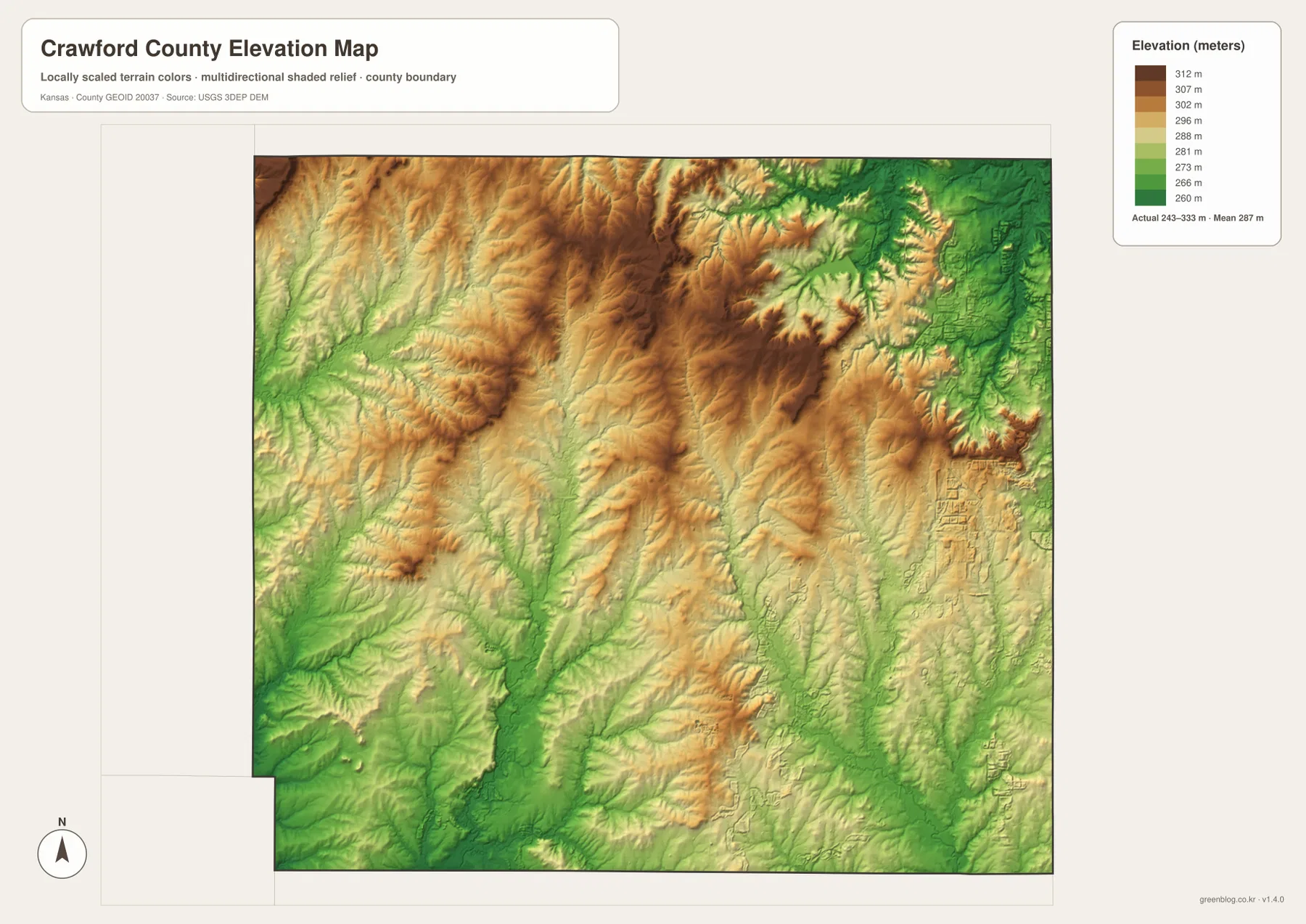
This elevation map is designed for county-scale comparison, not parcel surveying or engineering. It is useful for seeing why Pittsburg and the southeast appear relatively low, why higher ridges are prominent north of Girard, and how the Cow Creek and Lightning Creek valleys cut through the county. Exact elevations for construction, drainage design, or legal survey work require purpose-built data and professional methods.
Cherokee Lowlands, Osage Cuestas, and the industrial landscape
Kansas Historical Society describes Crawford County as part of both the Cherokee Lowlands and the Osage Cuestas. The supplied elevation map gives a visual way to understand that transition. Lower and more gently colored terrain is widespread in the southeast, while central and northern sections contain more pronounced ridges and valleys. The boundary between physical regions is not a legal line on the county map; it is better understood as a gradual change in landform and relief.
The county’s industrial history is closely tied to the southeast. Kansas Historical Society notes that Pittsburg began as a coal-mining camp in 1876 and later became a major center for coal and zinc-smelting industries. Crawford County includes part of the Pittsburg-Weir coalfield, and rail connections helped the mining district grow. The close spacing of Pittsburg, Frontenac, Arma, and nearby communities makes more sense when viewed against that history of mining, rail transport, and industrial development.
Girard became the county seat in 1868 and remains the administrative center, while Pittsburg grew into the county’s largest city. The two roles explain why Crawford County has more than one obvious center on a map. Girard anchors county government and the central road network, while Pittsburg anchors the largest urban area, Pittsburg State University, and the denser eastern transportation corridor. Reading the county through both cities avoids reducing the geography to a single dominant point.
Choosing the right map and using the download
For basic orientation, start with the general map and locate Pittsburg, Girard, U.S. 69, and U.S. 400. Add Frontenac, Arma, Cherokee, and Mulberry to see how the eastern and southern settlements are distributed. This version works well for county introductions, classroom handouts, and route context because it combines place names, highways, and the county boundary in one view.
For physical geography, begin with the Cow Creek system, Lightning Creek, and Farlington Lake on the terrain and water map. Then compare those features with the elevation surface to see how the northern ridges and southern or eastern valleys fit together. The city map is more useful when the goal is simply to explain the relative locations of Pittsburg, Frontenac, Girard, Arma, Cherokee, and Mulberry without the distraction of smaller roads and drainage lines.
The high-resolution JPG files in the ZIP are better suited to printing or enlarged viewing than the reduced web previews. Each file corresponds to one of the supplied web maps. Anyone reusing or adapting the maps should check the source and attribution requirements connected with the underlying data. Current road conditions, live water levels, or exact parcel elevations should be verified with up-to-date authoritative sources rather than inferred from these county reference maps.
Frequently Asked Questions
Is Girard or Pittsburg the county seat of Crawford County?
Girard is the county seat of Crawford County. Pittsburg is the county’s largest city and the most prominent urban area on the supplied maps. Girard is therefore the better reference for county government, while Pittsburg is the better reference for the largest city, Pittsburg State University, and the U.S. 69 urban corridor.
Where are Cow Creek and Farlington Lake on the map?
Cow Creek runs along the eastern side of the county, with First Cow Creek and Second Cow Creek farther west. Farlington Lake is in the northern part of Crawford County, with Frisco Lake nearby. These features are useful geographic landmarks, but current water levels or recreation conditions require current official information.
Can the 243–333 meter elevation map be used for exact surveying?
No. The elevation map is a county-scale reference for comparing ridges, valleys, and broad relief. Parcel elevations, engineering, drainage design, and legal surveys require more precise data and methods designed for those purposes.
Map File Information
Download the high-resolution JPG files corresponding to the Crawford County general, city, terrain-and-water, and elevation maps in one ZIP archive.
- Included Files: Use only the versions confirmed in the article and supplied images
- File Type: Use the confirmed download contents
- Intended Use: Printing, education, presentations, and map-based projects
Related Maps
Sources and references
- Crawford County, Kansas official website — county government and local information
- Kansas Historical Society — Crawford County, Kansas — county seat, Pittsburg, mining history, and physical regions
- U.S. Census Bureau TIGER/Line Shapefiles — boundary and geographic data resources
- USGS National Hydrography — hydrography and stream-network data information
- USGS 3D Elevation Program — elevation data information
Green Map creates custom-edited map images using open geographic data sources such as geoBoundaries, Natural Earth, OpenStreetMap, and government open data.
These maps are edited visual materials, not raw data files, and are provided for education, documents, presentations, and graphic reference.