Cowley County in south-central Kansas is easiest to understand by starting with Winfield and Arkansas City. Both major cities sit in the western half of the county, U.S. 77 links them north to south, and the landscape changes noticeably toward the smaller communities and creek-cut uplands in the east. The map set on this page separates roads and places, ranked city distribution, waterways, and elevation so each layer stays readable. High-resolution JPG versions of the supplied maps are available together in the ZIP download box farther down the page.
Relief is a major part of the county story. The elevation map shows an actual range of about 280 to 484 meters and a mean near 383 meters. Low green terrain follows the Arkansas River and Walnut River in the west and southwest, while broad orange and brown uplands occupy much of the east and northeast. Grouse Creek, Cedar Creek, Otter Creek, and smaller tributaries cut narrow green valleys through those higher ridges, giving the eastern half a much more dissected appearance than the river lowlands around Arkansas City.
The Kansas Historical Society places Cowley County within the Flint Hills Uplands, Wellington-McPherson Lowlands, and Arkansas River Lowlands. That mix is visible in the maps without needing a hard boundary line: broad river country dominates the west, while increasingly rugged uplands appear toward Burden, Dexter, Cambridge, and the eastern county line. Winfield, the county seat, works as the best settlement anchor, and the Walnut-Arkansas river system provides the clearest natural reference for tying the county together.
Table of Contents
Winfield and Arkansas City anchor the western half of Cowley County
On the general map, Winfield occupies a prominent position in the west-central part of the county. U.S. 77 passes through the area, and an east-west route connects the city with communities farther into the county. The Kansas Historical Society identifies Winfield as the county seat, which matches its visual importance on the map. Arkansas City lies farther south and forms the other major population center, so most first-time readers can establish county orientation simply by locating these two cities before looking east.
Arkansas City sits near U.S. 77 and the west end of U.S. 166 within the county, while Winfield provides access toward U.S. 160 and the Burden-Cambridge corridor. Udall lies to the northwest, Parkerfield is close to Arkansas City, and smaller labels such as Silverdale and New Salem help fill in the rural interior. The pattern is not a continuous urban strip. Instead, two larger centers dominate the west while smaller communities are separated by long stretches of farmland, roads, and drainage.
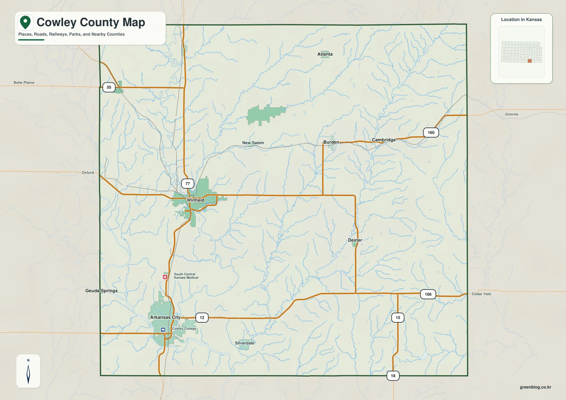
The eastern half of the general map is less dependent on city labels. U.S. 160 provides a clear route through Burden and Cambridge, while roads near Dexter connect south toward U.S. 166. Chautauqua County and Elk County lie beyond the eastern side, with Sumner County to the west. These neighboring areas help orient the county boundary, but the map is intended for county-scale geography rather than live driving. Current construction, closures, and travel times should be checked with an up-to-date transportation or navigation source.
A ranked city view shows how settlement is distributed
The city distribution map ranks six displayed communities, with Arkansas City first and Winfield second. Udall, Burden, Dexter, and Parkerfield follow in the index. The ranking matters less than the geography: Arkansas City and Parkerfield sit close together in the southwest, Winfield is farther north, Udall occupies the northwest, and Burden and Dexter are separated from the western cluster by a broad rural interior. That arrangement helps explain why the county cannot be summarized by one urban corridor.
Road and river geography reinforces the same pattern. U.S. 77 creates a strong north-south relationship between Winfield and Arkansas City, and the Walnut River also bends south from the Winfield area toward the larger Arkansas River system near Arkansas City. Burden and Dexter occupy higher, more dissected country to the east, where smaller creeks and ridges become more important orientation features. Linking each city to a road or water feature makes the distribution easier to remember than treating the names as an isolated list.
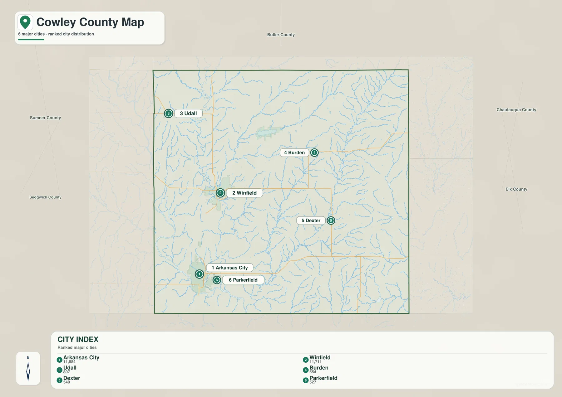
The city map also labels nearby counties around the outside of Cowley County, including Butler, Chautauqua, Elk, Sedgwick, and Sumner. Those references are useful for understanding which side of the county points toward the Wichita area and which side approaches the Oklahoma line. Because the ranked city view simplifies roads, it is best used for settlement orientation. Actual driving distances and route choices should be checked on the general road map or a current navigation service.
Walnut River descends toward the Arkansas River lowlands
The terrain-and-water map makes the western river system immediately visible. Walnut River enters from the northwest, winds through the Winfield area, and continues south toward Arkansas City. The Arkansas River forms a broad low corridor across the southwest. Together they explain why the western side of the elevation map is greener and lower than most of the eastern county. The river valleys are not just blue lines; they occupy wider low terrain that influences where roads, towns, and flatter ground appear.
Spring Creek and other small tributaries feed the Walnut River from the west and north, while Timber Creek Lake appears in the northern interior. Moving east, Silver Creek, Grouse Creek, Cedar Creek, and Otter Creek become more prominent. Grouse Creek runs through the central-southern part of the county, and the Cedar and Otter systems carve long valleys through the higher eastern terrain. This drainage network gives the eastern half a finely cut texture that is easy to miss on a simple road map.
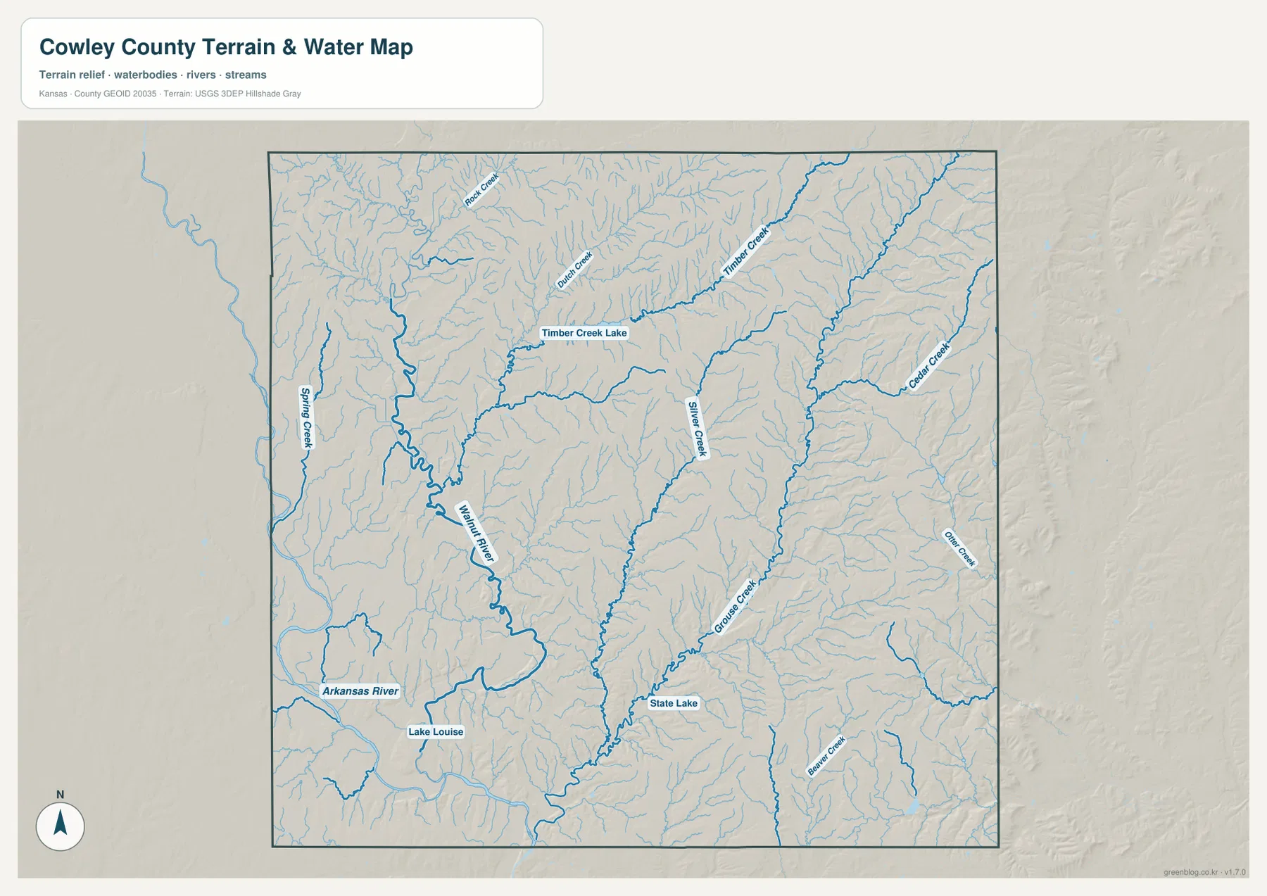
Lake Louise and State Lake are marked in the southern half, and Beaver Creek appears toward the southeast. These smaller water features add local reference points beyond the two major rivers. The map is designed to show drainage and terrain relationships, not current water levels, flood warnings, or water quality. Anyone who needs present-day streamflow or hazard information should use the latest observations from USGS or the responsible local and state agencies.
Elevation rises from 280-meter river country to 484-meter eastern ridges
Cowley County spans roughly 280 to 484 meters in the elevation surface, with an average near 383 meters. The lowest terrain follows the Arkansas River and lower Walnut River in the west and southwest. Green also extends into some northwestern valleys. Farther east, tan, orange, and brown become dominant as the county rises into rolling uplands. Long green creek valleys cut through those higher surfaces, so the eastern side looks like a network of ridges rather than one continuous plateau.
The northeast and east show some of the strongest local relief. Cedar Creek, Otter Creek, and Grouse Creek occupy narrow lower corridors between much higher ground, while the center of the county contains a broad transition from the western lowlands to the eastern uplands. The terrain east of Winfield toward Burden and Dexter generally becomes higher, although individual creek valleys repeatedly interrupt that rise. South of the main urban centers, low ground follows the major rivers before relief increases again toward the eastern side.
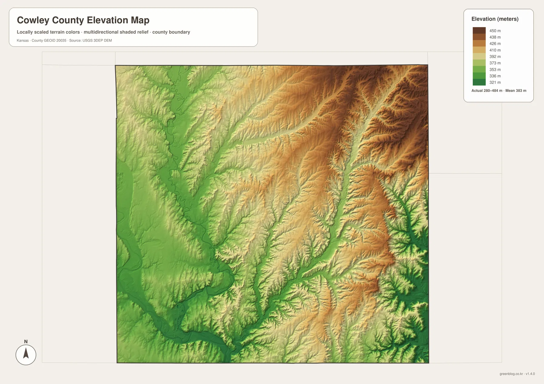
This visible contrast fits the Kansas Historical Society description of Cowley County as including the Arkansas River Lowlands, Wellington-McPherson Lowlands, and Flint Hills Uplands. The map does not mark those regions with legal boundaries, but the transition is easy to recognize in the terrain. Elevation colors are appropriate for county-scale comparison, not survey work. Exact parcel elevations, construction design, drainage engineering, and legal measurements require more precise data and professional methods.
Burden, Dexter, and Cambridge sit in a different landscape from the western cities
The eastern communities provide a useful contrast with Winfield and Arkansas City. Burden and Cambridge lie along the U.S. 160 corridor, while Dexter is farther south and connects toward U.S. 166. None matches the size of the two western population centers, but each becomes an important reference in a part of the county where city labels are otherwise sparse. As the road map moves east from Winfield, creek crossings become more frequent and the elevation surface becomes noticeably higher and more rugged.
Dexter is close to the broader Grouse Creek drainage, and Cambridge sits near a landscape cut by Cedar Creek and many smaller tributaries. Timber Creek and its lake give the north-central area another natural landmark. These relationships make the eastern settlements easier to place: rather than memorizing only the highway numbers, readers can associate Burden, Dexter, and Cambridge with the upland-and-creek country that separates them from the broad western river lowlands.
A useful way to explore the county is to establish Winfield and Arkansas City first, then move east through Burden, Dexter, and Cambridge while comparing the terrain and water views. The western side is organized by large cities and broad rivers; the east relies more on smaller communities, creek valleys, and ridges. That shift within one county gives Cowley County a distinctive geography that would be lost in a generic description of southern Kansas.
Choosing the map that matches the question
For basic orientation, begin with the general map and locate Winfield, Arkansas City, and U.S. 77. U.S. 160 and U.S. 166 then extend the reference frame into the eastern county. The city distribution map is useful when the goal is to compare where Arkansas City, Winfield, Udall, Burden, Dexter, and Parkerfield sit relative to one another. For physical geography, start with the Walnut and Arkansas rivers, then trace Grouse Creek and the eastern tributaries before checking how those valleys line up with the elevation colors.
The high-resolution JPG files are the better choice for large screens, printed pages, or documents where small road and stream labels need to remain legible. The web previews are optimized for quick viewing, while the ZIP retains larger map images for closer inspection. These files are reference maps, so projects that depend on current road status, legal property boundaries, flood conditions, or exact elevations should combine them with the latest authoritative information.
Frequently Asked Questions
How are Winfield and Arkansas City connected on the map?
Winfield is the county seat in the west-central part of Cowley County, and Arkansas City lies farther south. U.S. 77 provides the main road connection, while the Walnut River also bends south from the Winfield area toward the Arkansas River system near Arkansas City. Using both road and river geography makes the relationship between the two major centers easy to understand.
Why does eastern Cowley County look higher and more rugged?
The elevation map places much of the western Arkansas and Walnut river country near the low end of the county range, while large parts of the east rise above 400 meters. Cedar Creek, Otter Creek, Grouse Creek, and many tributaries cut valleys into that higher ground, creating closely spaced ridges that are much less prominent in the western lowlands.
Can these water and elevation maps be used for surveying or flood decisions?
No. They are county-scale reference maps for comparing terrain and drainage. Exact parcel elevations, legal boundaries, engineering design, and current flood risk require purpose-specific data, professional survey information, and the latest observations from responsible agencies.
Map File Information
Download the high-resolution map files
- Included Files: Use only the versions confirmed in the article and supplied images
- File Type: Use the confirmed download contents
- Intended Use: Printing, education, presentations, and map-based projects
Related Maps
Sources and references
- Cowley County, Kansas official website — county government and local information
- Kansas Historical Society — Cowley County, Kansas — Winfield, county history, and physiographic regions
- U.S. Census Bureau TIGER/Line — boundary, road, and geographic data resources
- USGS National Hydrography — rivers, streams, and hydrography information
- USGS 3D Elevation Program — elevation data information
Green Map creates custom-edited map images using open geographic data sources such as geoBoundaries, Natural Earth, OpenStreetMap, and government open data.
These maps are edited visual materials, not raw data files, and are provided for education, documents, presentations, and graphic reference.