Idaho County is so large that its shape and terrain make more sense when the roads, settlements, rivers, and elevation are viewed together. The official county website describes it as the largest county in Idaho, covering about 8,503 square miles. Grangeville, Cottonwood, and several of the most visible road junctions sit toward the western side, while an enormous mountain interior extends east and south through river canyons and high ridges. This page uses separate maps to show the county boundary and roads, the relative position of major communities, the principal waterways, and the broad elevation pattern. High-resolution JPG versions of the same maps are also available to download.
A useful way to approach Idaho County is to start with Grangeville and then follow the landscape outward. U.S. 95 runs through the western settlement belt, while U.S. 12 turns east from the Kamiah and Kooskia area into the long mountain corridor. The terrain-and-water map shows why those routes occupy only a small part of the county: the Clearwater, Salmon, Lochsa, Selway, and several major forks cut through a rugged interior filled with deep valleys. The elevation map makes the contrast even clearer, with low river corridors surrounded by much higher ridges across the central, eastern, and southern parts of the county.
The WebP images in the article are designed for quick on-screen viewing. The downloadable ZIP contains larger original JPG files, which are better when you need to print the map or read small road and water labels. Begin with the county map to establish the boundary and main routes, use the city-connections map to compare Grangeville with Cottonwood, Kooskia, and Riggins, and then move to the water and elevation maps for the mountain interior. That sequence keeps a very large county from becoming visually overwhelming.
Table of Contents
Grangeville anchors the western road network while the county opens eastward
The county map places Grangeville in the broad western portion of Idaho County, with Cottonwood and Kamiah to the north. This is the part of the map where the most prominent town labels and numbered highways cluster. Farther east, the outline expands into a much larger mountain area with fewer large settlement labels and many more streams. That difference is useful before looking at any individual road: the western side provides the clearest reference points for orientation, while the eastern interior is defined more by river valleys and rugged terrain.
U.S. 95 is the strongest north–south road reference on the western side. It enters from the south, passes through the Grangeville and Cottonwood area, and helps tie the visible communities together. Near Kamiah, U.S. 12 turns east and follows the northern mountain corridor. Idaho 13, Idaho 14, and Idaho 162 also appear on the map, adding local connections around the western settlements and into the interior. Idaho 14 is especially useful as a visual reference because it leaves the Grangeville area and stretches east into country where settlement labels become much less frequent.
The county outline itself is another important clue. Idaho County has a complicated western edge, then broadens across an enormous central and eastern mountain block before narrowing toward the far northeast. Nearby labels such as Lewiston, Orofino, and Salmon help place that shape in north-central Idaho. Because the county covers such a large area, a place that appears only a few inches away on the screen may be separated by long mountain roads and river canyons in the real landscape. The base map is therefore most useful for understanding direction and major corridors rather than estimating travel time.
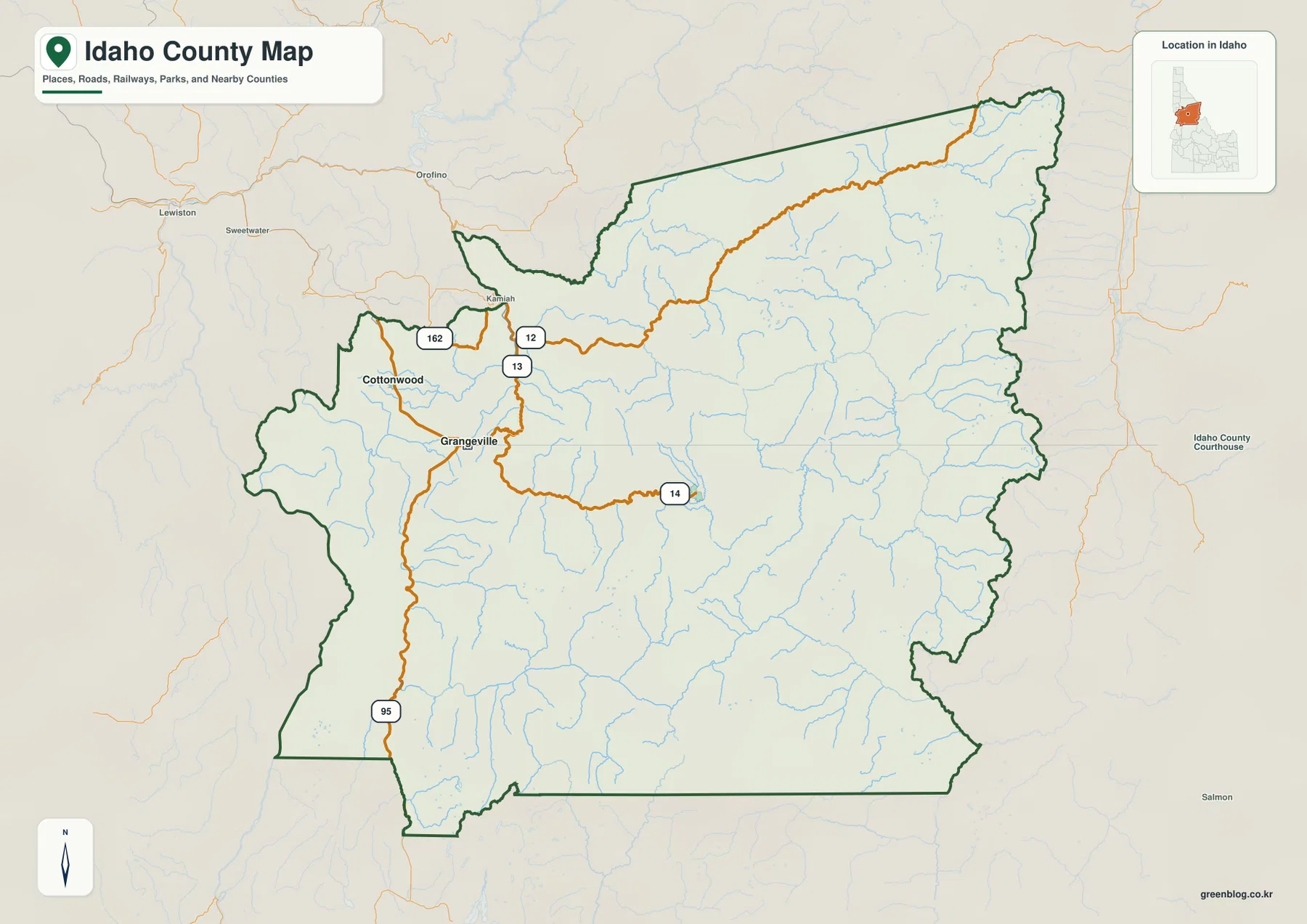
Use this map first when you need a road-and-place overview. It is the easiest version for locating Grangeville relative to Cottonwood and Kamiah, seeing where U.S. 95 runs north and south, and following U.S. 12 or Idaho 14 toward the mountain interior. It does not try to label every tributary or show exact elevation values. Those details are separated into the water and elevation maps so that the basic geographic framework remains readable.
Cottonwood, Kooskia, and Riggins reveal a settlement pattern tied to western valleys
The city-connections map uses Grangeville as the hub and compares it with Cottonwood, Kooskia, and Riggins. The labels show Cottonwood about 14 miles from Grangeville, Kooskia about 16 miles away, and Riggins about 36 miles away. These are straight-line distances, not driving distances. In a county with steep canyons and winding roads, the actual route between two places can be considerably longer, so the numbers should be used to compare relative spacing and direction rather than to estimate a road trip.
The arrangement of the four communities says a great deal about where the more visible settlement centers occur. Cottonwood lies north of Grangeville, while Kooskia is northeast toward the Clearwater River corridor. Riggins is much farther south, in the Salmon River canyon country. The large eastern half of the county has no comparable ranked city labels on this map. That empty space is not a lack of geography; it reflects how much of Idaho County is mountain and river country rather than a closely spaced network of towns.
Neighboring county names give additional orientation. Clearwater County and Latah County appear to the north, Nez Perce County lies to the west, Lemhi County is east of the long mountain interior, and Valley County is southwest near the Riggins side. These labels are useful for understanding which edge of Idaho County a community is closest to. They are not a substitute for a legal boundary survey, but they make the unusual size and shape of the county easier to interpret at a glance.
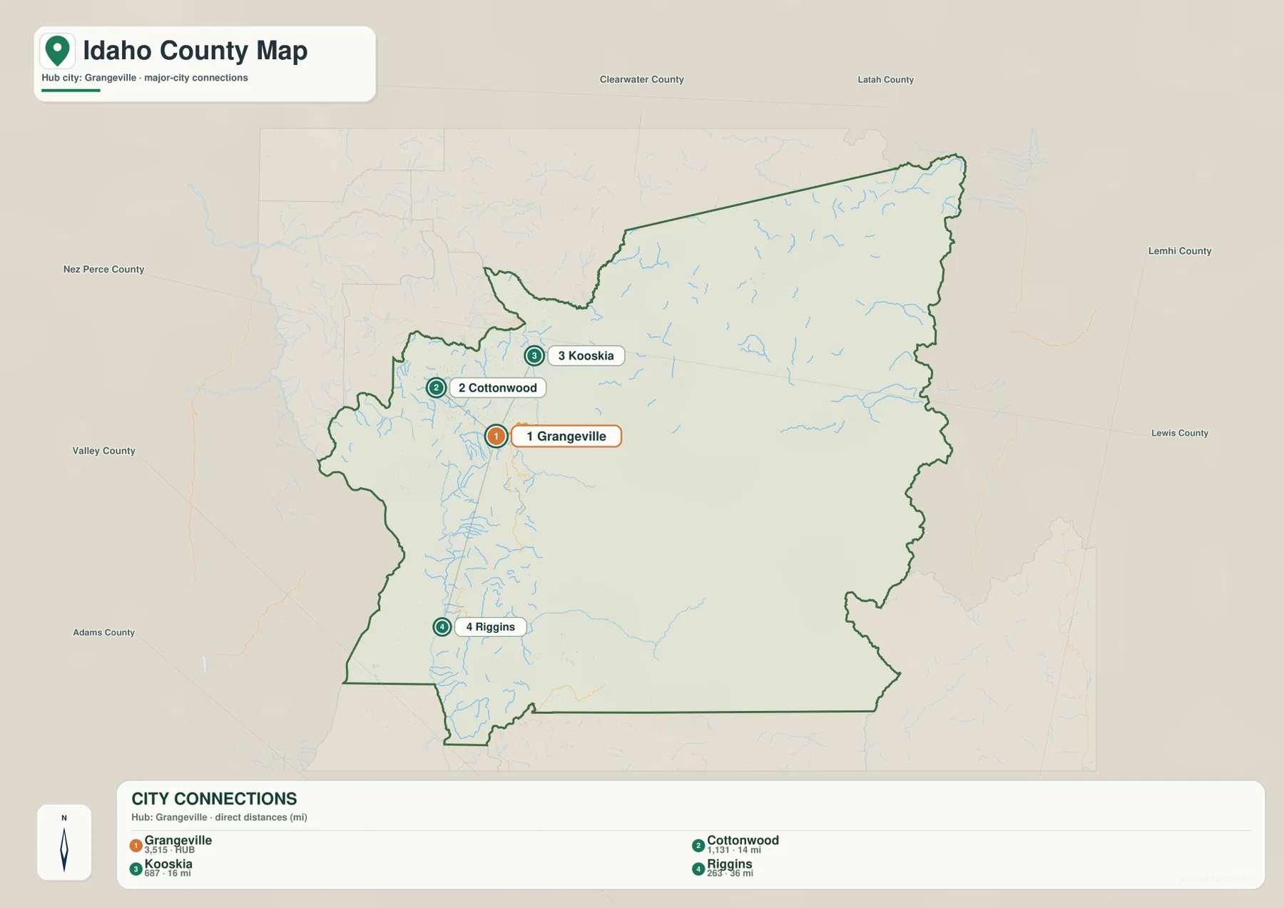
The practical value of this map is its simplicity. It strips away much of the road detail and lets you see that Grangeville and Cottonwood occupy the western upland area, Kooskia sits closer to the Clearwater drainage, and Riggins lies far to the south along the Salmon River corridor. If you need to plan a drive, return to the road map and then consult a current navigation service. If you only need the spatial relationship among the communities, the city map provides a clean summary.
Clearwater, Salmon, Lochsa, and Selway rivers cut through the mountain interior
The terrain-and-water map is the most useful version for understanding why Idaho County looks so rugged. In the northwest, the Clearwater River provides a major reference line, with the South Fork Clearwater River extending toward the Grangeville side. Farther northeast, the Lochsa River occupies a long valley through the mountains. The Selway River runs through the eastern and southeastern interior, while the Salmon River dominates the western and southwestern canyon system. Instead of one broad plain, the county is divided by a network of river valleys separated by high ridges.
The Salmon River corridor is especially important around the Riggins side of the county. The map also labels the Little Salmon River and the South Fork Salmon River, making it possible to distinguish several similarly named waterways that occupy different valleys. Following those labels explains why the southern part of Idaho County is difficult to summarize with a single road or town. The river network creates long, narrow routes through terrain that rises steeply on either side.
The eastern interior contains smaller named features that help with local orientation. Bear Creek appears near the eastern edge, and lakes such as Moores Lake, Crystal Lake, Bear Lake, Hazard Lake, and Black Lake are marked in the mountain country. These are not comparable in size or importance to the Clearwater or Salmon River systems, but they provide useful landmarks when reading a map that otherwise contains many similar ridges and tributaries. They also show that the county’s water geography includes mountain lakes as well as major rivers.
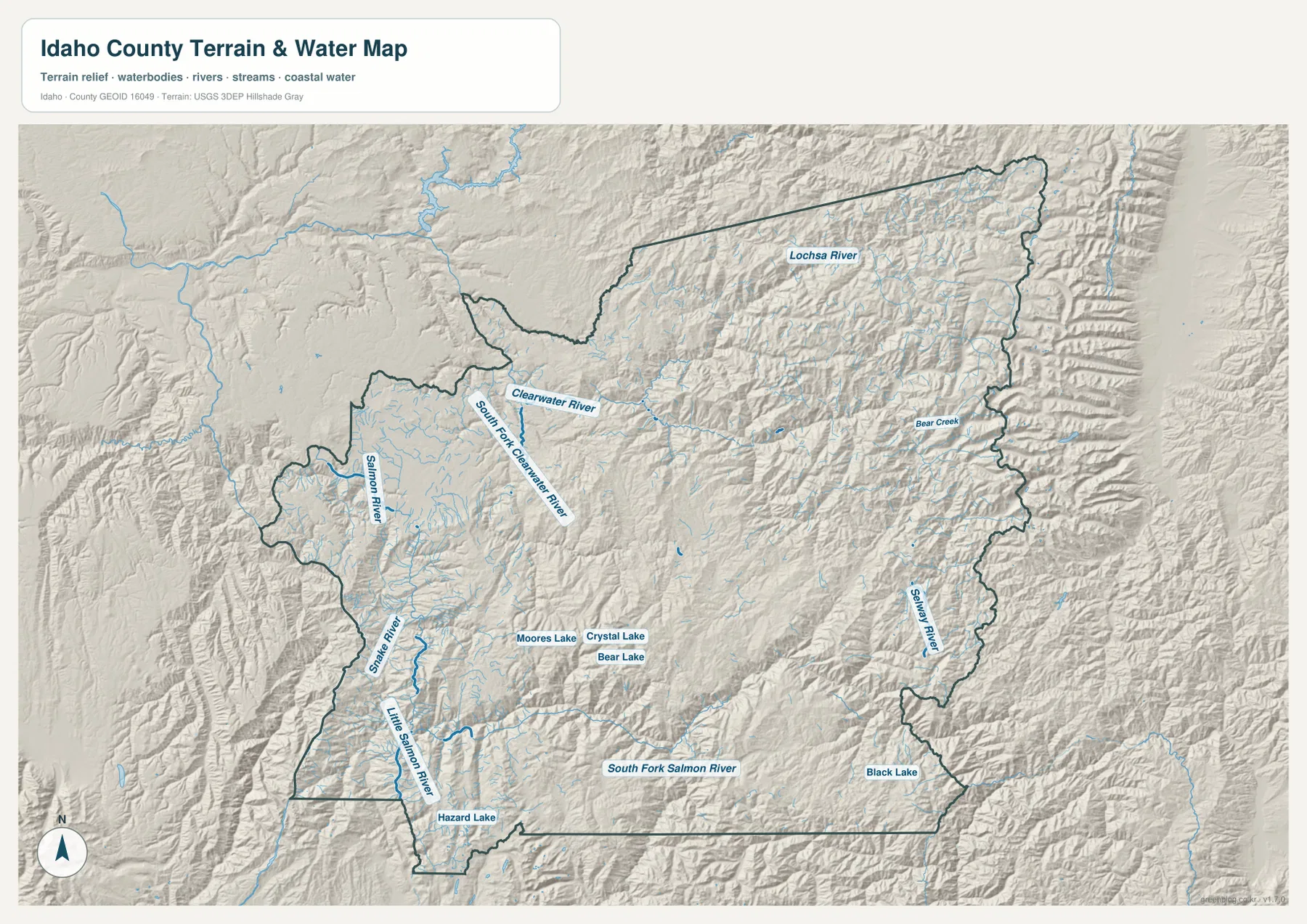
The shaded relief makes the relationship between water and terrain much easier to see. The Lochsa and Selway corridors are set within densely ridged mountain country, while the Salmon River occupies a deep canyon system in the west and south. The official Idaho County website identifies the Clearwater, Salmon, and Snake rivers among the major waterways associated with the county, and the map makes the Clearwater and Salmon systems especially prominent within the county boundary. Smaller tributaries then branch from those larger valleys throughout the interior.
This is a reference map for the location of rivers, creeks, lakes, and terrain. It is not a flood-risk map, parcel map, navigation chart, or source for current water conditions. Anyone making decisions about flood safety, boating, fishing regulations, land boundaries, or real-time river levels should use the appropriate current agency information. For general geographic reading, however, this map is the clearest way to see how strongly Idaho County is organized around river canyons.
Elevation rises from 283-meter canyon floors to 2,818-meter mountain ridges
The elevation map shows an actual range of roughly 283 to 2,818 meters, with a mean elevation of 1,556 meters. Deep river corridors appear in the lower green colors, especially toward the western Clearwater and Salmon drainage areas. Moving into the central and eastern interior, the colors shift through lighter greens and yellows into brown highlands. The eastern boundary and much of the southern mountain country contain repeated high ridges, creating a strong contrast with the narrow low valleys that cut through them.
Grangeville sits in a comparatively more open and moderate-elevation part of the county, although nearby terrain becomes complex quickly. The Kooskia and Clearwater River direction is marked by lower valley colors, and the Riggins–Salmon River corridor also appears as a deeply incised low route. Away from those rivers, elevation rises sharply. This helps explain why the water map shows such long, confined river valleys: the channels occupy low passages between much higher ridges.
The northeast and east are particularly intricate. High terrain does not form one smooth plateau. Instead, brown and yellow ridges alternate with narrow green valleys, many of which correspond to the Lochsa, Selway, and their tributaries. The southern part of Idaho County repeats the same general pattern around the Salmon and South Fork Salmon systems. Looking back and forth between the elevation and water maps is one of the fastest ways to understand how the county’s rivers fit inside its mountain terrain.
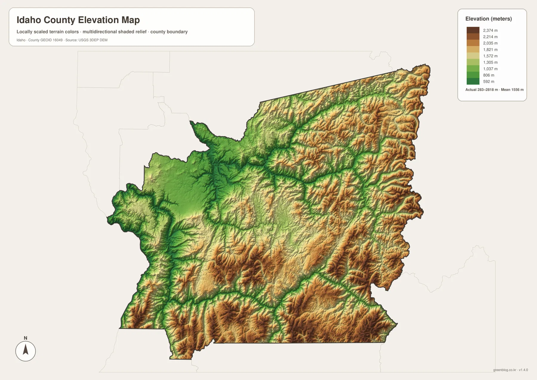
The elevation surface is intended for county-scale comparison, not survey-grade measurement. It is useful for seeing which valleys are low, where the mountain blocks rise, and how elevation changes across the county as a whole. It should not be used to determine the exact elevation of a building site, road point, or engineering location. For precise elevation work, consult the original USGS elevation data or an appropriate surveyed source.
Choosing the clearest map for a county this large
A practical starting point is the western settlement belt, where Grangeville, Cottonwood, Kamiah, U.S. 95, and U.S. 12 provide recognizable anchors. The boundary-and-road map keeps those references clear while also showing how far the county stretches into the mountains. If the question is simply where Cottonwood, Kooskia, and Riggins sit relative to Grangeville, the city-connections view strips away most of the terrain detail and emphasizes direction and straight-line separation. Those distances are comparison values rather than driving routes.
River-focused questions are easier to answer with the terrain-and-water map, where the Clearwater, Salmon, Lochsa, and Selway systems stand out against the shaded mountain surface. When the main question is why those valleys are so deep or why settlement is sparse in the interior, the elevation map adds the missing context by showing low canyon floors beside much higher ridges. Since the county outline is consistent across the set, a road or community found on the base map can be matched with the river corridor and surrounding relief without relying on a list of map types.
The downloadable JPG files are especially useful when small labels need to remain readable in print or on a larger screen. Each original image is 3638×2572 pixels, larger than the WebP previews shown in the article. The ZIP contains one JPG corresponding to each map shown here: the county base map, the city-connections map, the terrain-and-water map, and the elevation map. You can use only the version that matches your purpose instead of trying to combine every type of information into one crowded image.
The official county site describes Idaho County as covering about 8,503 square miles, which helps explain why no single map can make every feature equally prominent. The western road network, the Salmon River canyon, the Clearwater drainage, and the eastern mountain interior are all important for different reasons. Starting with the base map and then switching to the specialized version you need is a much clearer way to work with a county of this scale.
Frequently Asked Questions
Are the distances from Grangeville to Cottonwood, Kooskia, and Riggins driving distances?
No. The city-connections map uses straight-line distances. It shows Cottonwood at about 14 miles, Kooskia at about 16 miles, and Riggins at about 36 miles from Grangeville. Actual driving distance can be longer because roads follow river valleys, mountain passes, and canyon terrain. Use the figures for directional comparison, then consult a current road service when you need a route or travel time.
Which map is best for following the Salmon, Lochsa, and Selway rivers?
The terrain-and-water map is the best choice for those features. It labels the Salmon River, Little Salmon River, South Fork Salmon River, Clearwater River, South Fork Clearwater River, Lochsa River, Selway River, and several smaller lakes and creeks. The base map is better for towns and highways, while the water map gives the river system much more visual emphasis.
Does the download contain the same maps shown in the article?
Yes. The ZIP contains high-resolution JPG versions of the county base map, city-connections map, terrain-and-water map, and elevation map shown on this page. Each JPG is 3638×2572 pixels. The WebP images in the article are optimized for screen viewing, while the JPG originals are better for printing or reading small map labels.
Map File Information
Download the high-resolution JPG map files for Idaho County in one ZIP. Use these larger originals when you need more detail than the on-page WebP previews.
- Included Files: county base map, city-connections map, terrain-and-water map, elevation map
- Printable Size: 3638×2572 pixels for each JPG
- File Type: ZIP containing 4 JPG files
Related Maps
Sources and references
For county-specific information, including the county’s size and general regional description, see the Official Idaho County Site. Current population and demographic statistics are available from U.S. Census Bureau QuickFacts: Idaho County, Idaho.
Boundary and base geography can be checked with U.S. Census Bureau TIGER/Line Shapefiles. Water features can be referenced through USGS National Hydrography, and elevation information through the USGS 3D Elevation Program.
Green Map creates custom-edited map images using open geographic data sources such as geoBoundaries, Natural Earth, OpenStreetMap, and government open data.
These maps are edited visual materials, not raw data files, and are provided for education, documents, presentations, and graphic reference.