Toole County occupies a long north–south stretch of northern Montana, running from the Canadian border to the Marias River country south of Shelby. Shelby is the main reference point on the maps, while Sunburst and Kevin sit farther north and Sweet Grass marks the border end of the county. The maps on this page show the county outline, roads and settlements, straight-line city connections, named waterways and lakes, and the broad changes in elevation. High-resolution JPG versions are available in the download box below for printing, classroom work, reports, and general geographic reference.
The easiest way to orient yourself is to notice Interstate 15 and U.S. 2. I-15 runs north from Shelby toward Sunburst and the international border, while U.S. 2 crosses Shelby from east to west. Those roads explain only part of the county, however. The northeastern corner rises into noticeably higher terrain, a network of creeks cuts through that upland, and the Marias River occupies a lower corridor across the southern part of the county. Comparing the road, water, and elevation maps makes the county’s internal contrasts much clearer than a single general map can.
Table of Contents
Shelby anchors the road network and the irregular southern county outline
On the general county map, Shelby is the best place to begin. It sits in the south-central part of Toole County where I-15 and U.S. 2 provide strong north–south and east–west reference lines. The Toole County Courthouse is also in Shelby, and the county’s official website lists the courthouse there as the center for county offices. From this point, the map becomes easier to read: I-15 continues north toward Sunburst, Kevin lies to the west of that corridor, and a web of numbered local and state routes reaches across the broad rural areas to the east and west.
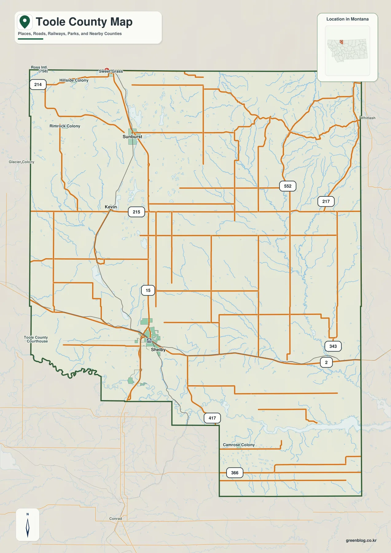
North of Shelby, Sunburst lies close to I-15, while Kevin is offset to the west rather than sitting directly on the interstate corridor. Sweet Grass appears at the far northern edge where travel continues toward Canada. The map also labels routes 215, 217, 343, 366, 417, and 552, which helps show how east–west local travel spreads away from the main interstate. Instead of forming a dense urban street pattern, the road system crosses large open areas and links small communities, rural properties, and widely separated parts of the county.
The county shape is worth noticing as well. Much of the northern and eastern edge is comparatively straight, but the southern and southwestern boundary steps inward and bends through a more complicated outline. South of Shelby, the county narrows before widening again farther east. That shape matters when you compare the boundary map with the water and elevation maps, because the Marias River and its low corridor occupy the same broad southern zone. For school projects, regional comparisons, or basic administrative reference, this general map is the most useful place to confirm where roads and communities sit inside the county line.
Sunburst and Kevin show how widely northern settlements are spaced
The city-connections map simplifies the county by using Shelby as a hub and comparing it with Sunburst and Kevin. The distances printed on this map are straight-line distances, not driving distances. Sunburst is shown about 27 miles from Shelby, and Kevin about 19 miles away. Those numbers are useful for judging scale and direction, but a road trip will usually cover more distance because vehicles must follow the actual road network. The map should therefore be read as a quick spatial comparison rather than as a routing or travel-time guide.
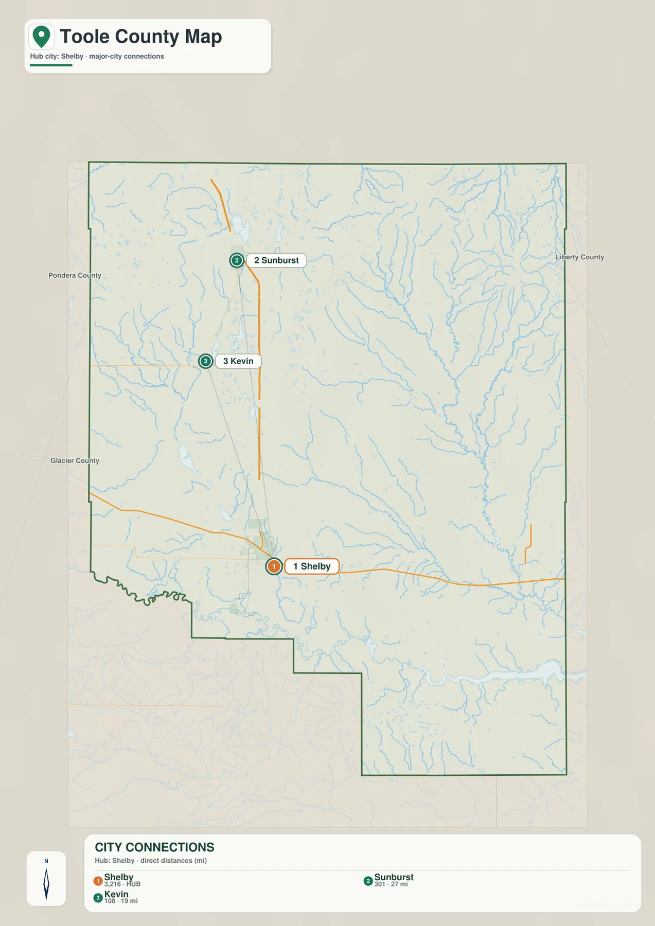
Looking at the connection map beside the general map adds useful context. Sunburst sits along the northbound I-15 corridor, giving it a direct visual relationship with Shelby. Kevin is west of that line, so its position is different even though both communities are north of the county seat. Sweet Grass lies farther north still, close to the Canadian boundary. This arrangement makes Toole County feel much larger than a map of Shelby alone would suggest: the main settlements are dispersed along a long north–south span rather than clustered tightly around one metropolitan center.
This map is especially helpful when introducing the county to someone unfamiliar with northern Montana. Start with Shelby, locate Sunburst and Kevin relative to it, and then return to the general map to see which roads actually connect the places. The two maps answer different questions without duplicating each other. One emphasizes real roads and boundaries; the other strips away most detail so the spacing between communities stands out. That difference is useful in teaching, trip planning at a broad scale, or explaining county geography in a report.
Marias River lowlands contrast with the Willow Creek network in the northeast
The terrain-and-water map reveals a different county. Across the south, the Marias River forms the most prominent named watercourse and follows a low corridor that can also be recognized on the elevation map. In the northeast, Willow Creek is joined by a more intricate group of tributaries, including Sheep Creek, Trail Creek, and Dice Creek. These streams descend through higher, more dissected terrain before entering lower country. Their branching pattern is easy to miss on the road map but becomes one of the strongest features once the waterways are emphasized.
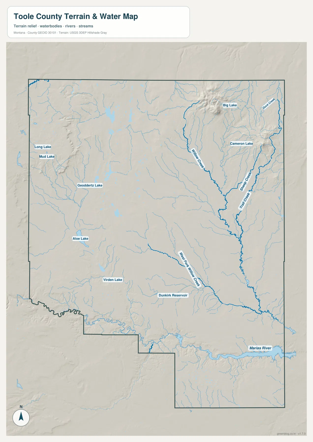
Several named lakes help fill out the picture. Long Lake and Mud Lake appear close together in the western part of the county, with Goeddertz Lake farther to the southeast. Aloe Lake and Virden Lake lie farther south, while Big Lake and Cameron Lake are set near the higher northeastern terrain. Dunkirk Reservoir is labeled in the southern interior. These water bodies are not all the same type or used for the same purpose, so the map should not be treated as a classification of natural lakes, reservoirs, recreation areas, or water-supply facilities. Its strength is showing where the named water features lie in relation to the county’s landforms.
Willow Creek is particularly useful for seeing how water and relief fit together. The main creek runs out of the northeastern uplands, and smaller branches join it from several directions; West Fork Willow Creek is also labeled farther south and west. By contrast, the Marias River follows a broad, lower route across the southern part of the county. That difference becomes more meaningful when the elevation map is viewed next. The branching creeks are associated with higher and more broken ground, while the southern river corridor sits in a lower band that stretches across the county.
This is a reference map, not a flood-hazard, parcel, navigation, or water-depth product. It should not be used to decide whether a particular property floods or whether a stream can be crossed safely. For those questions, current information from the appropriate government agency is necessary. For general learning, however, the map is useful for locating named streams and lakes, comparing the northern and southern drainage patterns, and seeing how the Marias River provides a strong geographic reference across the lower part of Toole County.
Northeastern uplands rise well above the central prairie and Marias corridor
The elevation map makes the county’s strongest terrain contrast immediately visible. Two high areas stand out in the northeast and along the eastern side, shown in brown and tan against a much broader green interior. Higher ground also appears near parts of the western edge, but the central prairie is generally lower and smoother. In the south, the Marias River corridor forms a distinct low band, with branching valley shapes cut into the surrounding surface. The result is not a uniformly flat county: large prairie areas are interrupted by uplands, creek valleys, and a pronounced southern river corridor.
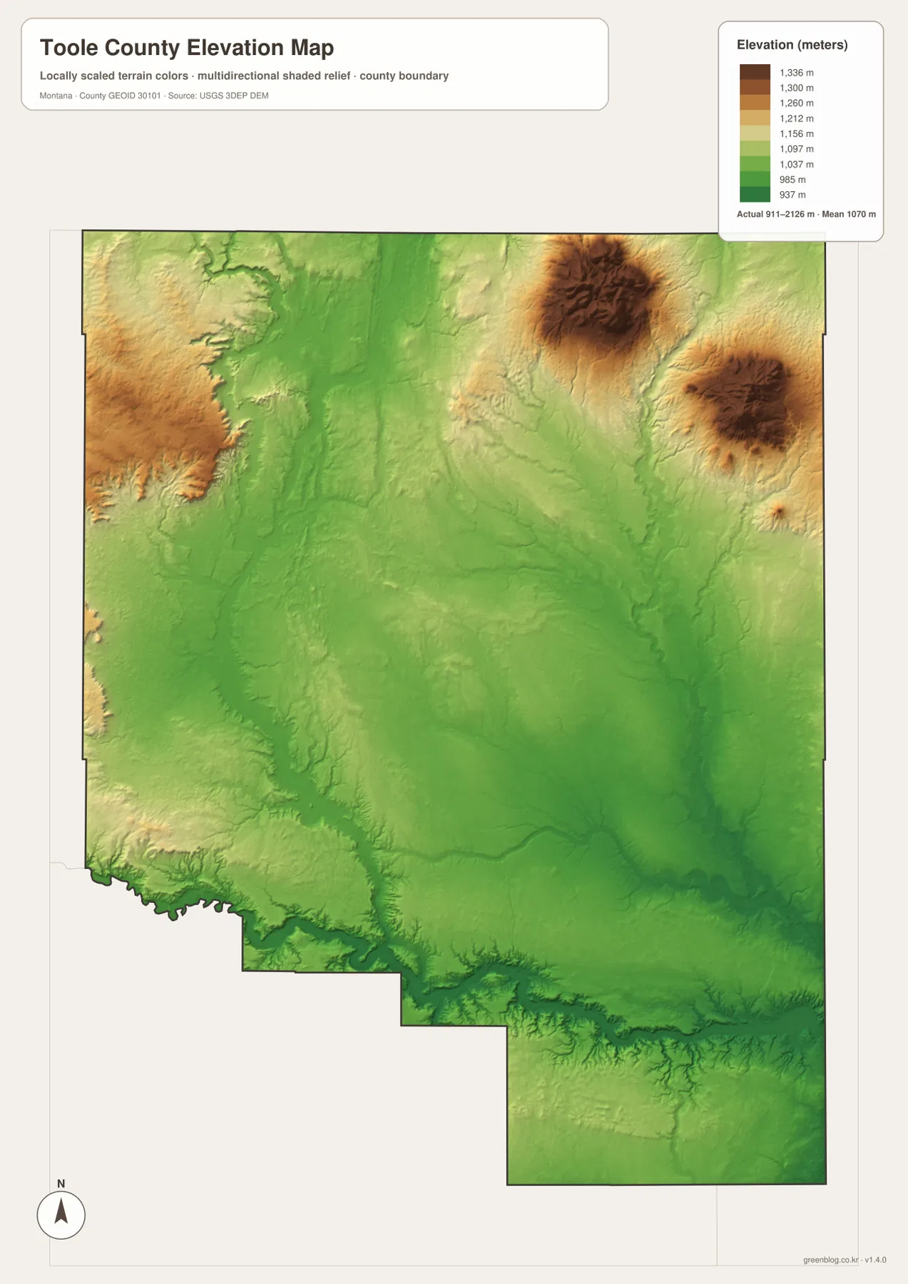
The legend reports an actual elevation range of roughly 911 to 2,126 meters and a mean near 1,070 meters. Those figures help communicate the countywide difference in height, but they are not precise measurements for individual parcels, roads, or structures. The colors are designed to compare broad terrain zones rather than to replace detailed topographic or engineering data. Anyone planning field work, construction, or surveying should consult higher-resolution official elevation products and current local information.
When the elevation and water maps are compared side by side, several relationships become easier to understand. The Willow Creek system and its tributaries occupy the more varied northeastern terrain, while the Marias River traces a lower corridor across the south. Shelby lies outside the county’s highest uplands in the lower, gentler central-southern terrain. Sunburst and Kevin also appear within broad prairie country rather than inside the rugged high areas. This helps explain why the road network and the main settlements look relatively open and widely spaced even though the county contains substantial relief in its outer sections.
Using the four views together clarifies how roads, water, and relief interact
A useful reading sequence begins with Shelby on the general map. From there, follow I-15 north toward Sunburst and the Canadian border, then use the city-connections map to judge the spacing of Sunburst and Kevin. Next, switch to the water map to locate the Marias River, Willow Creek, and the scattered lakes. The elevation map then explains why the northeastern drainage looks more complex and why the southern river corridor forms such a strong low feature. Each view removes some information and emphasizes something else, so comparison is more informative than trying to force every detail into one map.
For example, a northbound trip from Shelby is defined mainly by I-15 on the road map, while the city map places Sunburst about 27 straight-line miles from the hub. The water map shows many creeks crossing the wider landscape in directions that do not match the highway, and the elevation map reveals higher terrain toward the northeast. South of Shelby, the emphasis changes: the Marias River and its low valley become the strongest physical features. The maps therefore show that northern and southern Toole County are organized around different geographic cues even though they belong to the same administrative county.
Choose the map that matches the task. Use the general map when county boundaries, roads, and settlements matter most; use the city-connections version when the relative position of Shelby, Sunburst, and Kevin is the main point. The terrain-and-water map is best for named rivers, creeks, lakes, and reservoirs, while the elevation version is the clearest choice for explaining the northeastern uplands and lower Marias River country. For decisions requiring exact road conditions, legal boundaries, flood information, or survey-grade heights, pair these reference maps with the latest official source.
Frequently Asked Questions
Are the Shelby-to-Sunburst and Shelby-to-Kevin distances driving distances?
No. The city-connections map shows straight-line distances from Shelby: about 27 miles to Sunburst and about 19 miles to Kevin. Actual road mileage will vary with the route and exact starting and ending points. Use the map to compare direction and spacing, and use a current road map or navigation service when planning a drive.
Which map is best for finding the Marias River and Willow Creek?
The terrain-and-water map is the best choice. It shows the Marias River in the south, Willow Creek and tributaries such as Sheep Creek and Trail Creek in the northeast, and named water bodies including Big Lake, Cameron Lake, and Dunkirk Reservoir. It is a geographic reference map, not a flood-risk, depth, or navigation product.
What stands out most on the Toole County elevation map?
The most obvious contrast is between the higher northeastern and eastern uplands and the lower central prairie and Marias River corridor. The legend reports a countywide actual range of about 911 to 2,126 meters. Those values are useful for understanding broad relief, but the map is generalized and should not replace detailed topographic or survey data for a specific site.
Map File Information
The download includes the Toole County general map, city-connections map, terrain-and-water map, and elevation map as original high-resolution JPG files.
- Included Files: Use only the versions confirmed in the article and supplied images
- File Type: Use the confirmed download contents
- Intended Use: Printing, education, presentations, and map-based projects
Related Maps
Sources and References
- Toole County official website – county offices and courthouse information in Shelby
- U.S. Census Bureau TIGER/Line Shapefiles – county boundary and transportation reference data
- USGS National Hydrography – river, stream, and waterbody reference data
- USGS 3D Elevation Program – elevation data reference
Green Map creates custom-edited map images using open geographic data sources such as geoBoundaries, Natural Earth, OpenStreetMap, and government open data. These maps are edited visual materials, not raw data files, and are provided for education, documents, presentations, and graphic reference.