Fulton County sits at the far western edge of Kentucky, where the Mississippi River shapes one of the state’s most unusual county outlines. Hickman anchors the river side of the county, while the city of Fulton lies near the eastern end close to the Tennessee line. This page explains the county boundary, major roads, the two principal cities, named waterways, and the mapped elevation range of about 82 to 150 meters. The same four maps shown in the article are also available as high-resolution JPG files in a single ZIP download for printing or closer reference.
The county’s most distinctive feature is the detached western section visible beyond the main body. Fulton County’s official website identifies this area as Madrid Bend and explains that early surveying of Kentucky’s southern border left the county in two non-contiguous parts. On the maps, the great curve of the Mississippi River makes that separation easy to understand. Reading the river, Hickman, and Fulton together gives a much clearer picture of the county than treating it as a simple rectangular area.
Table of Contents
A long county between Hickman and Fulton
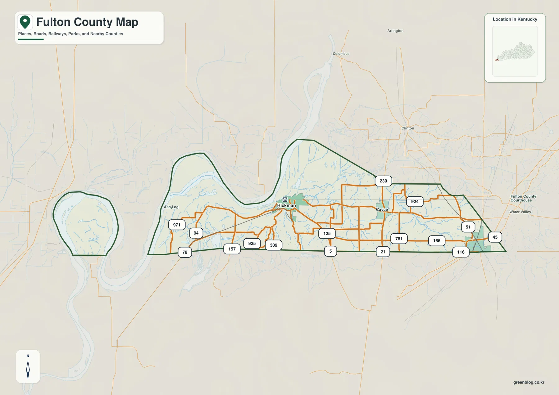
Hickman appears near the western side of the main county body, close to the Mississippi River, while Fulton occupies the far eastern end. Between them, the map shows a network of Kentucky routes rather than one single dominant corridor. KY 94 and KY 125 are useful reference roads around Hickman and the central portion, while U.S. 51 and KY 45 stand out near Fulton. Additional numbered routes—including 5, 21, 78, 116, 157, 166, 239, 309, 781, 924, 925, and 971—fill in the local connections.
The western and eastern halves look noticeably different. Around Hickman, the county boundary follows a landscape strongly influenced by the Mississippi and smaller wet lowlands, so roads and local lines bend around water features. Near Fulton, road junctions are more prominent and the urban area is easier to locate from the highway pattern. The county stretches a considerable distance east to west, so using both cities as reference points is more practical than trying to orient the whole county from only one place.
The basic county map is especially useful when a reader needs the boundary and transportation context at the same time. The detached Madrid Bend portion is visible to the west, the main county body stretches eastward, and Hickman sits where river geography becomes most important. Fulton, at the opposite end, is framed by U.S. 51, KY 45, and nearby state routes. This makes the map useful for explaining why two places in the same small county can have very different geographic settings.
Two principal cities define the county’s settlement pattern
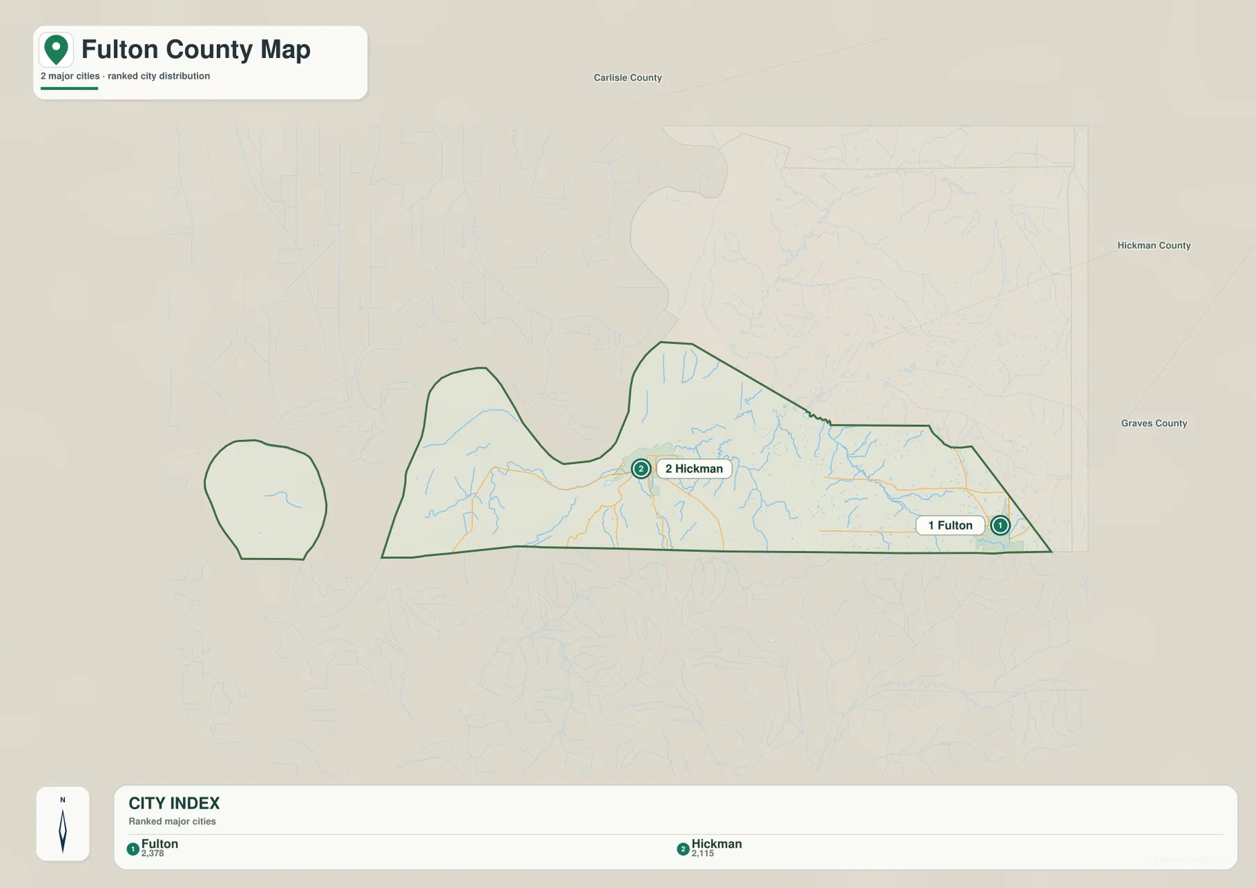
The city map reduces the county to its two principal incorporated places: Fulton and Hickman. Fulton is ranked first and Hickman second in the map’s city index, with reference values of 2,378 and 2,115. Those numbers are best treated as internal comparison values from the supplied map package rather than as a claim about current official population. What matters visually is that the two cities are similar enough in importance to provide paired reference points for opposite sides of the county.
Hickman is the county seat and represents the Mississippi River side of Fulton County. Fulton sits near the eastern boundary and is tied more closely to the U.S. 51 and KY 45 road pattern. Removing minor place labels from the city map makes the long distance between the two urban centers especially clear. For a classroom map, a presentation, or a quick orientation graphic, this simplified version is easier to read than the detailed road map.
The two-city view also helps organize the more detailed maps that follow. Starting from Hickman, a reader can focus on the Mississippi River, sloughs, and the detached western portion. Starting from Fulton, the eye moves toward the road network and the slightly higher eastern terrain. The rural middle of the county then becomes the connecting space between these two centers rather than an empty area with no geographic structure.
The Mississippi River and lowland waterways dominate the west
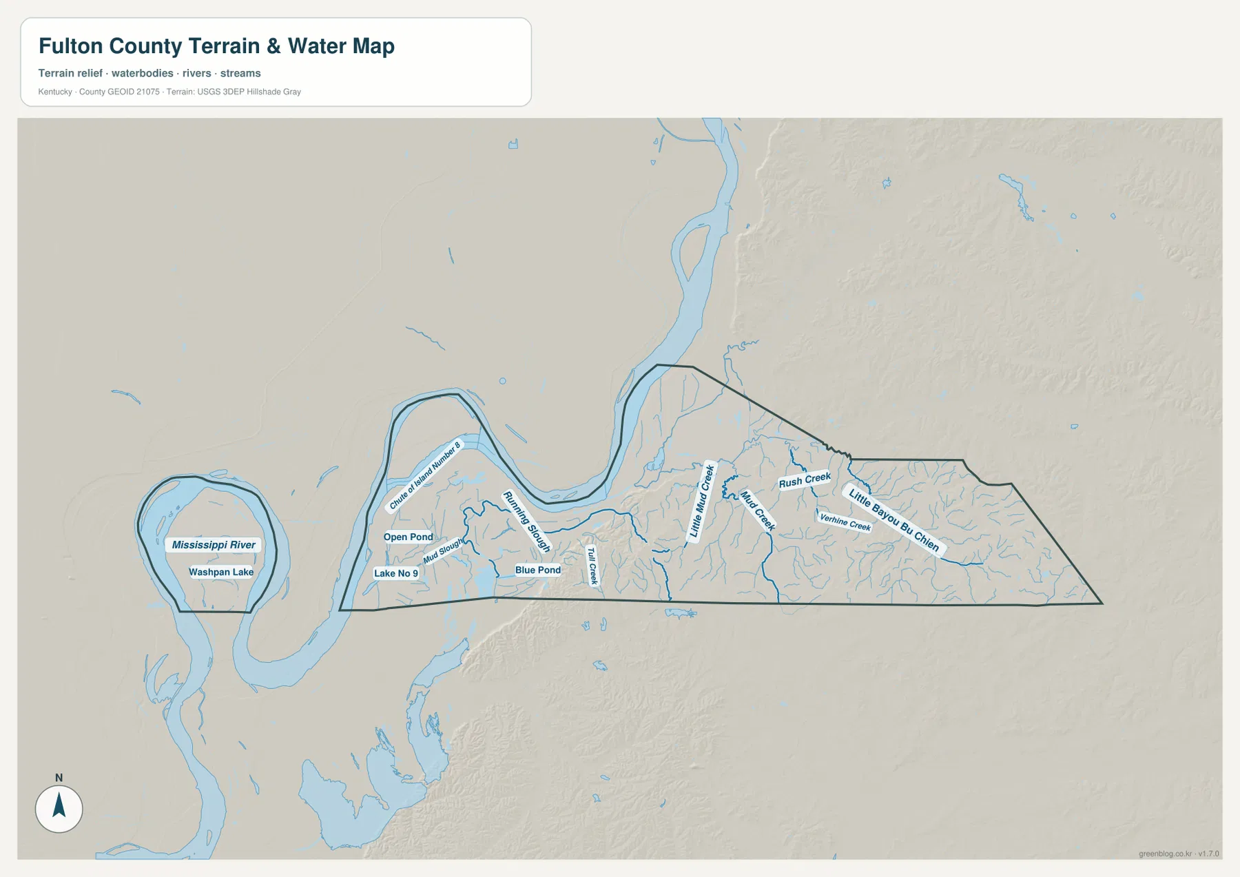
The terrain and water map is defined first by the Mississippi River. Its broad bends wrap around the western side of the county and help explain the unusual shape of Madrid Bend. Washpan Lake appears inside the detached portion, while the main county section includes names such as Chute of Island Number 8, Open Pond, Lake No 9, Blue Pond, and several sloughs. The western landscape is therefore not just a river edge; it is a complex lowland environment with multiple named water features.
Moving eastward from Hickman, smaller waterways become the most useful landmarks. Running Slough and Tilly Creek appear in the west-central portion, followed by Little Mud Creek and Mud Creek farther east. Rush Creek, Vorhies Creek, and Little Bayou de Chien help divide the eastern rural landscape into recognizable drainage areas. These names can be more useful than small road numbers when trying to identify a particular part of the county away from the two cities.
The water map should be read as a geographic reference, not as a flood-risk, navigation, or real-time river product. Mississippi River stages can change, and a static map does not show current levee conditions, flood warnings, or navigable channels. Its value here is in showing where the river, sloughs, ponds, lakes, and creeks sit in relation to the county boundary and to the road-and-city pattern seen on the other maps.
An 82–150 m elevation range reveals subtle east–west relief
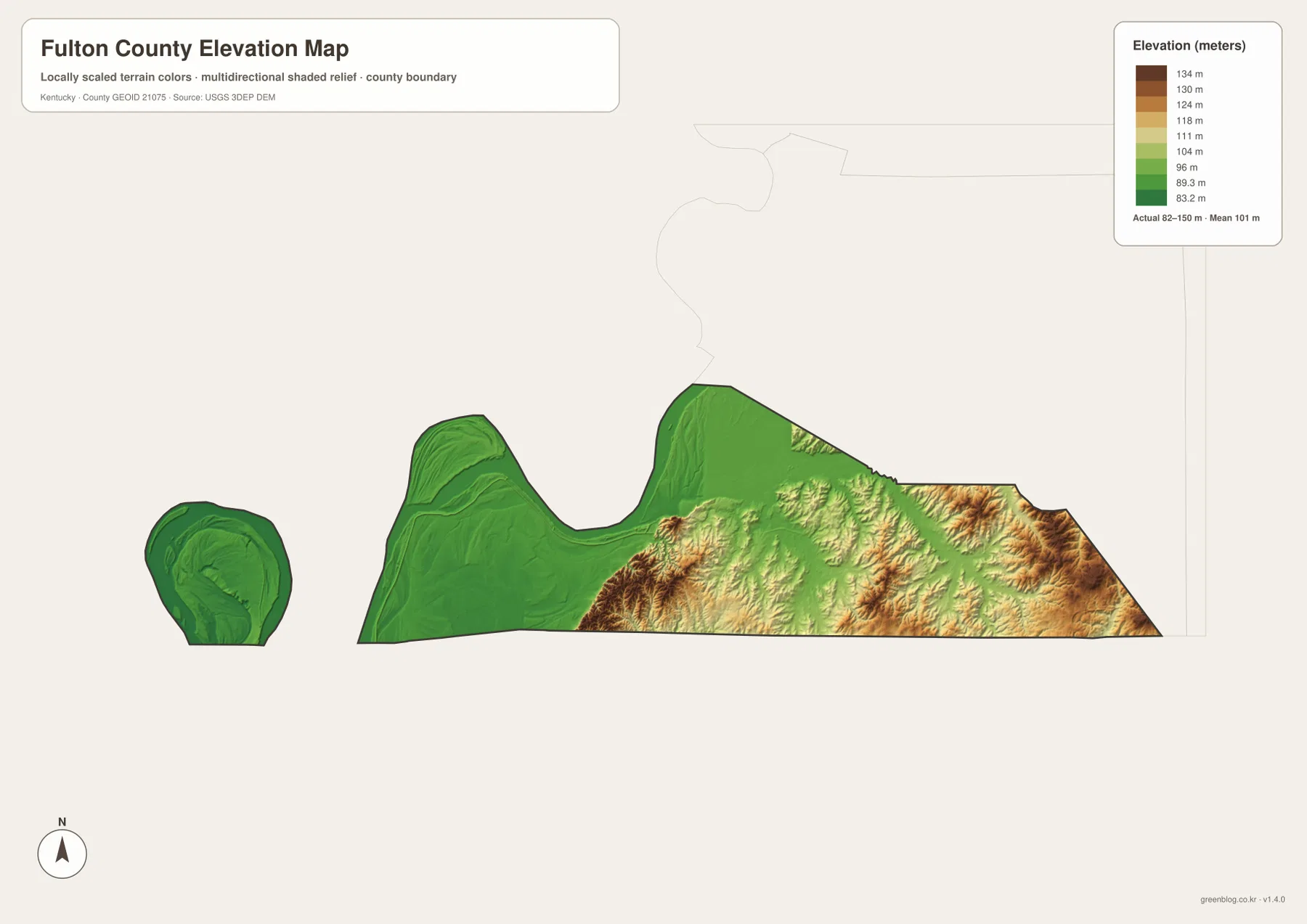
The supplied elevation map shows an actual range of about 82 to 150 meters, with a mean of 101 meters. Compared with the mountain counties of eastern Kentucky, Fulton County is very low and gently rolling. Even so, the map reveals a clear internal contrast. The Mississippi River side, including Madrid Bend, is dominated by the lowest green tones, while the eastern and southeastern parts of the main county body contain more yellow and brown ridges.
Hickman and the surrounding western lowlands occupy a landscape where small differences in height matter more than dramatic slopes. Former river channels, sloughs, and drainage lines create subtle relief that can be hard to notice on a road map alone. Farther east, short ridges and rolling ground become more visible in the shaded relief. Around Fulton, the terrain is still modest by statewide standards, but it is clearly higher than much of the Mississippi floodplain side of the county.
This generalized elevation surface is intended for regional comparison. It is not a survey-grade source for construction, levee design, property elevation, or engineering calculations. Its best use is to compare the low western river environment with the slightly higher eastern countryside and to see how named creeks tend to follow the lower parts of the landscape. The mean elevation of 101 meters should likewise be understood as a countywide summary, not the elevation of every locality.
Madrid Bend explains the county’s disconnected outline
The detached area west of the main county body is not a mapping error. Fulton County’s official website states that early surveying of Kentucky’s southern boundary resulted in two non-contiguous county sections and identifies the isolated portion as Madrid Bend. The county also notes that road access to the bend requires travel through Tennessee. That fact turns the small western outline into one of the most important geographic features on the entire map.
The water map makes the reason for this shape easier to visualize. The Mississippi forms a huge looping boundary around the area, while Washpan Lake and other lowland water features sit inside or near the bend. On the basic map, the detached section may look almost like a separate island of county territory. Reading the two maps together shows how a river meander and a surveyed state line can create a county geography that is much more complicated than a standard boundary map suggests.
For historical geography or boundary examples, Madrid Bend is the feature most worth highlighting. For legal parcel work, however, this map should not substitute for official surveyed boundary records. The article is meant to explain the large-scale relationship among the county outline, the river, and nearby roads, not to determine exact property ownership or jurisdiction at a particular coordinate.
Choosing the right map for roads, water, or relief
The general county map is the best starting point when boundaries, road numbers, Hickman, Fulton, and Madrid Bend all need to appear together. The city map is better when the goal is simply to explain where the two main population centers sit. For river geography and rural drainage, the terrain and water map provides much more detail, while the elevation map adds the subtle height differences that are difficult to see from roads and place labels alone.
Pairs of maps can be especially helpful. Comparing the county map with the water map shows why the western road network bends around river and lowland features. Comparing the water map with the elevation map reveals how creeks occupy lower corridors through the eastern countryside. Switching between the city map and the county map makes it easy to see how the two urban centers relate to the long rural section between them.
The downloadable package contains the high-resolution JPG originals for the county map, city map, terrain-and-water map, and elevation map. These files are larger than the WebP images used in the article, so they are better suited to printing, zooming into place names, or preparing a local geography handout. For flood safety, current road closures, legal boundaries, or engineering decisions, pair these reference maps with the latest specialized information from the responsible agency.
A quick way to read Fulton County at a glance
Three ideas summarize the county particularly well. Hickman is the western river-side center, Fulton is the eastern city, and Madrid Bend is the detached western section created by the county’s unusual boundary history. The Mississippi River provides the dominant physical feature, while the eastern half rises only modestly but consistently above the lowest floodplain terrain. Remembering those points makes the smaller roads and creeks much easier to place.
Because Fulton County has only two incorporated cities, roads and waterways carry more of the geographic detail than a dense network of town names would. Around Hickman, KY 94, KY 125, and the river are useful references. Around Fulton, U.S. 51 and KY 45 are more helpful. In the rural middle and east, Mud Creek, Rush Creek, Vorhies Creek, and Little Bayou de Chien provide additional landmarks. That combination of city, road, and water names gives a practical way to describe nearly any part of the county shown on the maps.
Frequently Asked Questions
What is the detached western part of Fulton County on the map?
It is a real part of Fulton County known as Madrid Bend. The county’s official website explains that the county is divided into two non-contiguous sections because of the early surveying of Kentucky’s southern border. The Mississippi River bend makes the detached shape especially clear on the water and boundary maps, and road access to the area requires traveling through Tennessee.
Where are Hickman and Fulton within the county?
Hickman is on the western side near the Mississippi River and serves as the county seat. Fulton is near the eastern end close to U.S. 51 and KY 45. The simplified city map highlights only these two places, while the general county map adds the roads and rural area that connect the two ends.
What should I look for first on the elevation map?
Compare the dark green Mississippi River lowlands with the yellow and brown terrain toward the east and southeast. The mapped range is about 82 to 150 meters, with a mean of 101 meters, so Fulton County is not mountainous. The useful distinction is the gradual rise from the very low western river environment to the somewhat higher rolling ground around the eastern half.
Map File Information
Download the Fulton County, Kentucky county map, city map, terrain-and-water map, and elevation map as high-resolution JPG originals.
- Included Files: county map, city map, terrain-and-water map, elevation map
Related Maps
Sources and references
Local information about Fulton, Hickman, Madrid Bend, and the county’s non-contiguous geography is available from the official Fulton County website. County boundary and administrative geography data can be checked through U.S. Census Bureau TIGER/Line. Waterway reference data are available from USGS National Hydrography, and elevation data are available from the USGS 3D Elevation Program.
These maps are static geographic references designed to explain the county’s roads, settlements, waterways, and relative relief. For current road closures, flood warnings, river stages, surveyed property boundaries, or other decisions that require up-to-date or legally precise information, consult the responsible agency’s current data in addition to these maps.
Green Map creates custom-edited map images using open geographic data sources such as geoBoundaries, Natural Earth, OpenStreetMap, and government open data. These maps are edited visual materials, not raw data files, and are provided for education, documents, presentations, and graphic reference.