Franklin County, Kentucky is easiest to understand by starting with Frankfort and the broad bends of the Kentucky River. I-64 and U.S. 60, 127, 421, and 460 converge around the city, while the river curves through the middle of the county before continuing south. This page explains the county boundary, main roads, settlement pattern, named streams and lakes, and the roughly 141–292 meter elevation range shown by the supplied maps. High-resolution JPG versions of the same maps are available together in the ZIP download below.
Frankfort occupies the south-central part of the county rather than the geometric center. Much of the land to the north and east is more lightly settled on the maps, so road numbers, creek names, and river bends become useful location clues once you leave the city. The four supplied map files work best as complementary references: one gives the broad road-and-place picture, another simplifies the city view, and the water and elevation maps add the physical landscape.
Table of Contents
Frankfort and the Kentucky River define the county’s center of attention
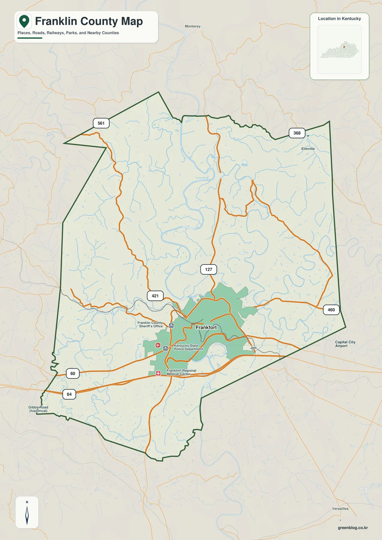
The general county map makes Frankfort the obvious reference point. The built-up area fills a substantial part of the south-central county, and several recognizable facilities are labeled around it, including the Franklin County Sheriff’s Office, Kentucky State Police Department, Frankfort Regional Medical Center, and Capital City Airport. Jett appears just east of the city, while Elmville provides a smaller place label toward the northeast.
Franklin County’s outer boundary is irregular rather than boxlike. A sharp projection extends into the northwest, while the western and southern edges contain smaller notches and bends. The broader location map labels Owen County to the north, Shelby and Scott counties to the east, Woodford and Anderson counties to the west, and Henry County toward the southwest. Those neighboring labels are helpful when you want to place a road or stream near the edge of Franklin County rather than simply near Frankfort.
I-64 and four U.S. routes organize travel around Frankfort
I-64 crosses the southern portion of the county from west to east, passing south of central Frankfort. U.S. 60 also runs across the city and connects the western side of the county with areas to the east. U.S. 127 leaves Frankfort toward the north and continues through a long stretch of rural county, while U.S. 421 provides an important west and northwest connection. U.S. 460 heads east, giving the map another clear reference line beyond the city.
Smaller state routes help identify areas that are farther from the main corridors. KY 561 is labeled in the northwest and KY 368 appears in the northeast. Roads are closely spaced around Frankfort but spread farther apart as they reach the northern half of the county, where curving valleys become more prominent. This static map does not show traffic, closures, or travel time, but it makes the direction and relationship of the main road corridors easy to compare.
The city index reduces the settlement pattern to Frankfort alone
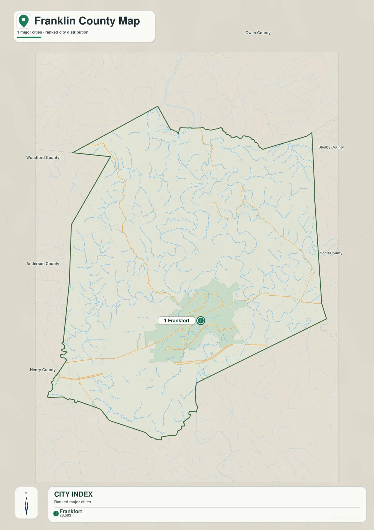
The city-index map labels only one major city: Frankfort. That makes this version unusually simple compared with county maps that contain several ranked cities. The index value printed on the map is best treated as a package reference rather than a claim about the latest official population. What matters most here is the visual point: Frankfort dominates the settlement pattern shown in the supplied city layer.
With smaller place and facility labels removed, Frankfort’s position inside the boundary is easier to see. The city sits well south of the county’s northern edge, leaving a large rural area above it. The same map also keeps neighboring county names visible, which helps explain Franklin County at a regional scale without crowding the page with minor settlement labels.
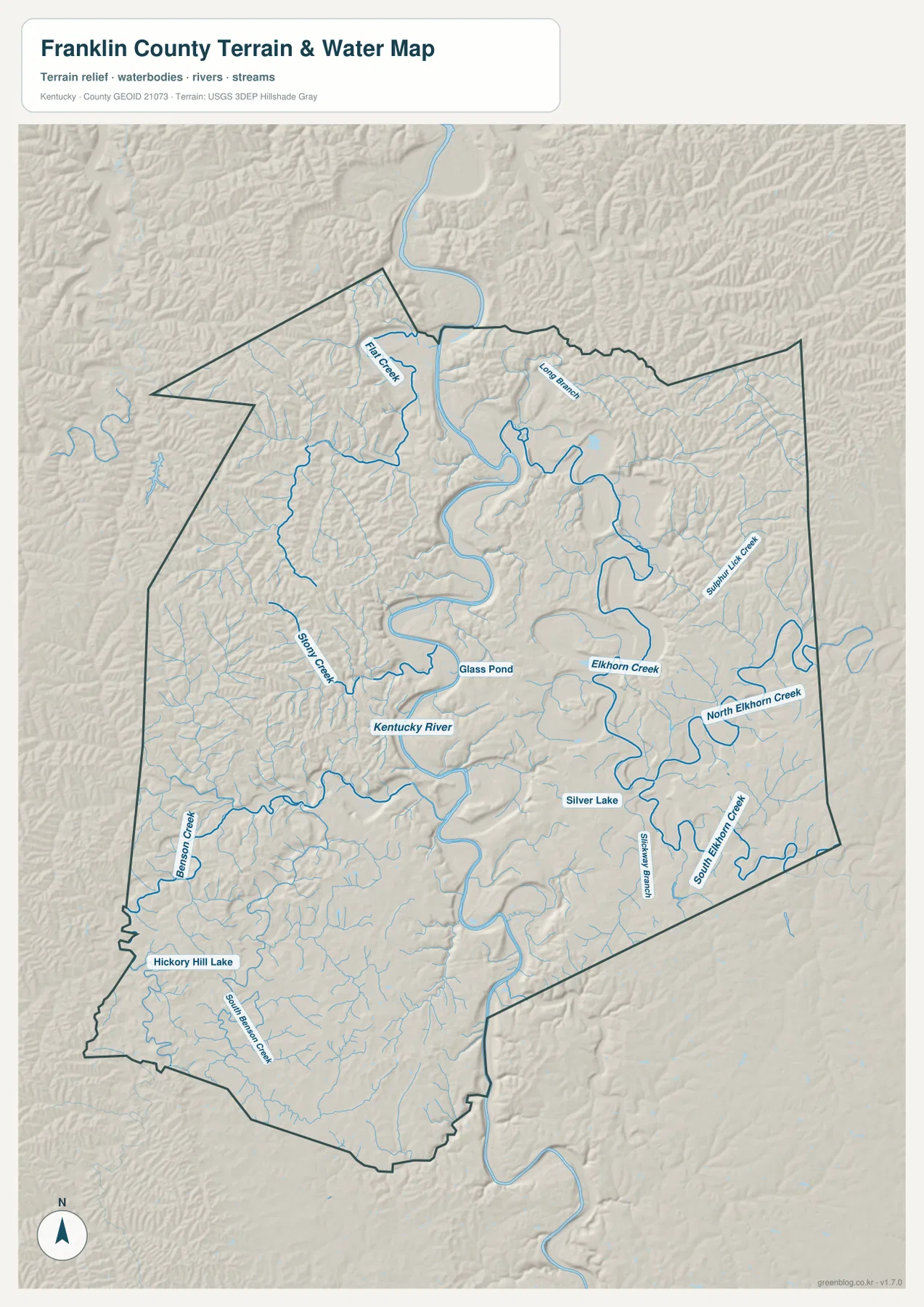
Kentucky River bends dominate the water map
The Kentucky River is the strongest physical landmark in Franklin County. It enters from the north, swings through a series of broad bends in the middle of the county, passes through the Frankfort area, and then continues south. Because the river repeatedly changes direction, two points that look close across a bend may depend on a bridge or a longer road connection in practice. Pairing the river with the road map gives a much clearer picture of local geography than looking at compass direction alone.
Elkhorn Creek is the most prominent named creek on the eastern side, with North Elkhorn Creek and South Elkhorn Creek shown as additional branches. Sulphur Lick Creek and Steadman Branch add more detail in the east. On the western side, Stony Creek and Benson Creek stand out, with South Benson Creek continuing through the southwest. Flat Creek and Long Branch provide useful labels toward the north.
The map also identifies several smaller water bodies. Glass Pond lies near the Kentucky River, Silver Lake appears farther southeast, and Hickory Hill Lake is labeled in the southwest. These are useful fixed landmarks when smaller valleys begin to look similar. The map is intended for geographic reference, not for flood-risk decisions, real-time water levels, water quality, or navigation; those uses require current agency data.
The 141–292 m range separates the river valley from the outer hills
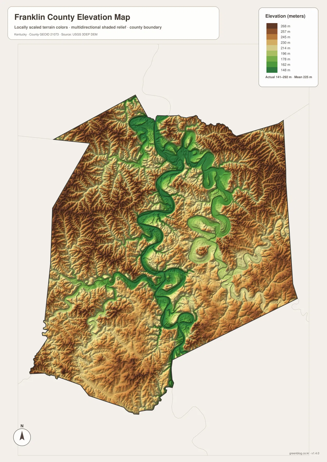
The elevation map reports an actual range of about 141 to 292 meters, with a mean of 225 meters. The lowest green tones follow the Kentucky River in a long, winding band through the center of the county. Low ground also extends through the major river bends north of Frankfort and along the river as it leaves the county to the south. The color pattern makes the river valley recognizable even before reading the stream label.
Higher brown and tan terrain spreads across much of the west, northwest, northeast, and other outer portions of the county. Elkhorn Creek creates another set of lower corridors in the east, but those valleys are surrounded by rolling uplands. Franklin County is not as vertically extreme as Kentucky’s Appalachian counties, yet the difference between the deeply cut river corridor and the surrounding hills is still pronounced enough to influence the shape of local roads.
The elevation colors are designed for county-scale comparison. They are not a substitute for a survey, engineering elevation, or parcel-specific measurement. For general map reading, though, the layer is valuable because it explains why the Kentucky River forms such a distinct low corridor and why many smaller creeks occupy narrow channels between higher ridges.
Use roads and streams together once you leave central Frankfort
Frankfort is such a strong landmark that locations elsewhere in the county can seem vague if you rely on the city alone. For the northern area, U.S. 127 works well when paired with the Kentucky River’s large bends. U.S. 421 and KY 561 help narrow the northwest, while the eastern side becomes easier to orient with U.S. 460, KY 368, and the Elkhorn Creek system. The combination of one road name and one water feature is often enough to distinguish similar-looking rural valleys.
U.S. 60 and I-64 serve different visual roles on the western and southern side. U.S. 60 passes through the Frankfort area as part of the local road network, whereas I-64 forms the clearest long east-west corridor across the south. Because the Kentucky River loops around the city and through the center of the county, road relationships can change quickly near crossings. Checking the river shape alongside the road map gives a more practical sense of location than measuring straight-line distance on the page.
Choose the file that fits the detail you need
The general county map is the best starting point when you need boundaries, road numbers, Frankfort, smaller place labels, and nearby context together. The city-index version is cleaner when the main question is simply where Frankfort sits inside Franklin County. The terrain-and-water map is better for river bends, creek names, and small lakes, while the elevation map is the quickest way to compare the Kentucky River valley with the higher outer hills.
The maps are also useful in pairs. Putting the general map beside the water map helps match road crossings with the Kentucky River, and comparing the water map with elevation shows how Elkhorn Creek, Stony Creek, and other streams occupy lower ground. For printing, classroom work, local orientation, or personal reference, the high-resolution JPG originals are included in the ZIP package below.
Frequently Asked Questions
Where is Frankfort located on the Franklin County maps?
Frankfort is in the south-central part of the county. I-64 passes to the south, while U.S. 60, 127, 421, and 460 connect the city with different parts of Franklin County and neighboring areas. The Kentucky River also bends through and around the Frankfort area, so the river and road network together make the city easy to identify.
How do the Kentucky River and Elkhorn Creek differ on the map?
The Kentucky River is the dominant waterway, winding through the middle of the county in a series of large bends. Elkhorn Creek is a major eastern creek system, with North Elkhorn Creek and South Elkhorn Creek labeled separately. Use the Kentucky River for the county’s broad physical layout and the Elkhorn branches for more detailed orientation on the eastern side.
What part of Franklin County is lowest on the elevation map?
The lowest colors follow the Kentucky River valley through the center of the county. The map gives an actual elevation range of about 141 to 292 meters and a mean of 225 meters. Higher tones become more common on the outer hills, making the river corridor easy to distinguish from surrounding uplands.
Map File Information
Download the high-resolution JPG originals for Franklin County’s general, city, terrain-and-water, and elevation maps in one ZIP file.
- Included Files: Use only the versions confirmed in the article and supplied images
- File Type: Use the confirmed download contents
- Intended Use: Printing, education, presentations, and map-based projects
Related Maps
Sources and references
County government information and local resources are available from the official Franklin County website. For state road and highway references, see the Kentucky Transportation Cabinet Printable Maps. County boundaries and administrative geography can also be checked through the U.S. Census Bureau TIGER/Line program.
Hydrography reference data are available through USGS National Hydrography, and elevation data are supported by the USGS 3D Elevation Program. These maps are static geographic references. Legal boundaries, parcels, flood-risk decisions, live road conditions, and engineering work should rely on the responsible agency’s current specialized data.
Green Map creates custom-edited map images using open geographic data sources such as geoBoundaries, Natural Earth, OpenStreetMap, and government open data. These maps are edited visual materials, not raw data files, and are provided for education, documents, presentations, and graphic reference.