Furnas County lies along Nebraska’s southern tier, where Beaver City serves as the county seat and Cambridge, Arapahoe, Oxford, Holbrook, and Edison form a stronger northern settlement belt. Republican River cuts a broad low corridor across the upper part of the county, while Beaver Creek creates another long valley through the south. Higher uplands dominate the west and southwest and are deeply incised by numerous tributaries. High-resolution map files are available for download in the section below.
This page explains the main communities and roads, the ranked distribution of six towns, Republican River, Bear Creek, Muddy Creek, Beaver Creek, Sappa Creek, canals, and an elevation range of about 616 to 778 meters. The original high-resolution JPG versions of the supplied maps can also be downloaded together in a ZIP for printing, classroom use, or personal reference.
Table of Contents
Beaver City is the county seat, even though the largest towns lie farther north
Beaver City is the Furnas County seat and occupies the east-central interior rather than the strongest population corridor. Furnas County’s official website identifies Beaver City as the seat and lists Cambridge, Arapahoe, Oxford, Holbrook, Edison, and other communities across the county. On the map, Beaver City is associated with Route 46 and a network of local roads that serve the surrounding agricultural area.
Cambridge and Arapahoe are farther north near U.S. 34 and U.S. 6, while Oxford lies close to the eastern boundary near U.S. 136. Holbrook and Edison fill out the same northern settlement belt. The distribution is unusual because the administrative center is separated from the county’s largest towns and most obvious highway corridor.
Furnas County was organized in 1873 and named for Robert W. Furnas, Nebraska’s governor at the time. The first county-seat contest became one of the county’s defining early events, with Beaver City and Arapahoe disputing election results through repeated votes and legal challenges before Beaver City ultimately secured the seat.
U.S. 34 and U.S. 6 create a continuous northern travel corridor
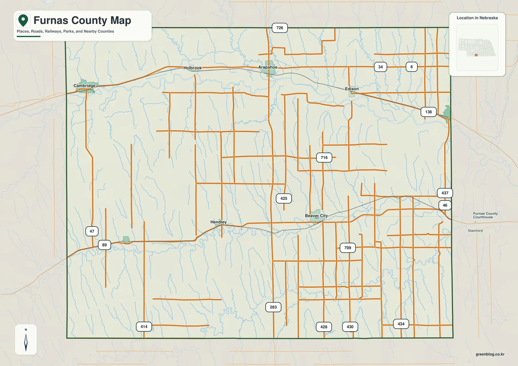
The strongest road corridor runs east-west across the north. U.S. 34 and U.S. 6 connect the Cambridge, Holbrook, and Arapahoe areas, and a rail line follows a similar direction. U.S. 136 continues along the eastern side toward Oxford, helping tie the northern and eastern communities into one broad transportation pattern.
U.S. 283 runs south from the Arapahoe area through the interior. Roads 47 and 89 serve the western side near Cambridge, while Routes 46 and 437 provide references around Beaver City and the eastern interior. Local roads numbered 425, 709, 716, 414, 428, 430, and 434 help organize the large rural spaces between towns.
The northern highways are relatively continuous, but central and southern local roads are repeatedly interrupted by narrow drainage valleys. Western Furnas County is especially dissected, so roads often bend around creek bottoms and ridges. The map is useful for orientation, while current construction, closures, road surfaces, and actual travel times should be checked with live Nebraska transportation information.
Six ranked towns emphasize the northern settlement belt
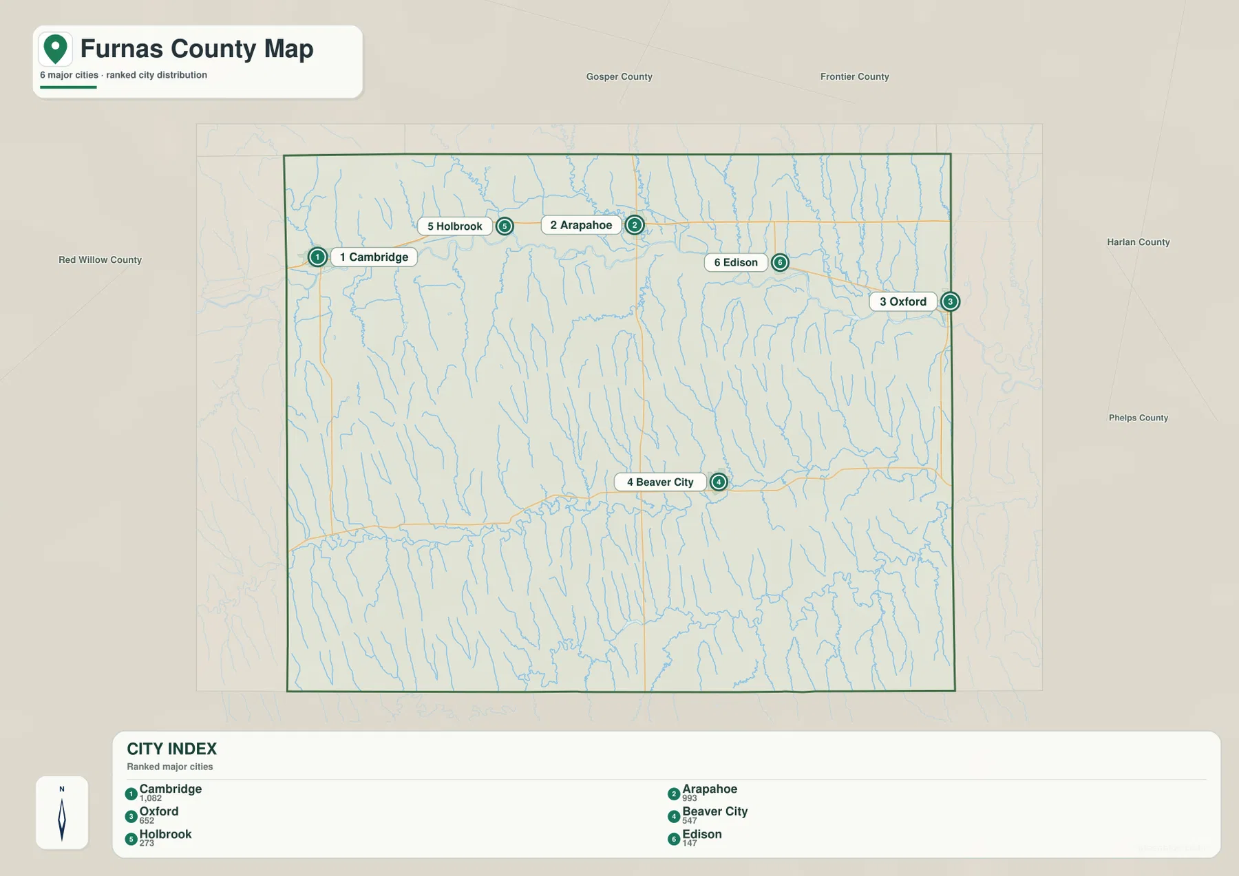
The city distribution map ranks Cambridge first, Arapahoe second, and Oxford third, followed by Beaver City, Holbrook, and Edison. Cambridge, Holbrook, Arapahoe, and Edison line up across the north, Oxford sits near the eastern edge, and Beaver City stands apart in the east-central interior.
No connector lines or mileage labels appear on the supplied city map. The useful comparison is therefore positional rather than numerical. Pairing it with the road map shows that the largest northern communities share stronger highway and rail access, while Beaver City remains the administrative center despite its more isolated inland location.
The values printed on the supplied city graphic are 1,082 for Cambridge, 993 for Arapahoe, 652 for Oxford, 547 for Beaver City, 273 for Holbrook, and 147 for Edison. They belong to the supplied ranking and should not be treated as a continuously updated population table. Current figures should be checked with the U.S. Census Bureau or local sources when needed.
Republican River and Beaver Creek create two major low corridors

Republican River is the dominant water feature across the northern part of the county. It passes through the broad Cambridge and Arapahoe valley, with Bartley Canal labeled on the west and Cambridge Canal farther east. The low river corridor is wide enough to stand out clearly from the dissected uplands on both sides.
North of the Republican, Bear Creek, Muddy Creek, Elk Creek, Dry Creek, and Turkey Creek descend toward the main river. Their narrow valleys split the northern uplands into repeated ridges. Thomas Creek and Crum Creek appear farther south of the river and add another set of drainage lines through the central interior.
Beaver Creek is the strongest southern drainage and follows a long eastward course before bending sharply in the eastern county. Sappa Creek and Maple Creek are labeled farther southeast. Together these waterways produce a second broad low corridor below the Republican system.
This water map is intended for geographic reference. It does not define flood zones, legal water rights, parcel boundaries, canal operations, current streamflow, channel depth, navigability, or public access. Those questions require current information from USGS and the responsible local or state agencies.
Western Furnas County rises more than 160 meters above its lowest valleys
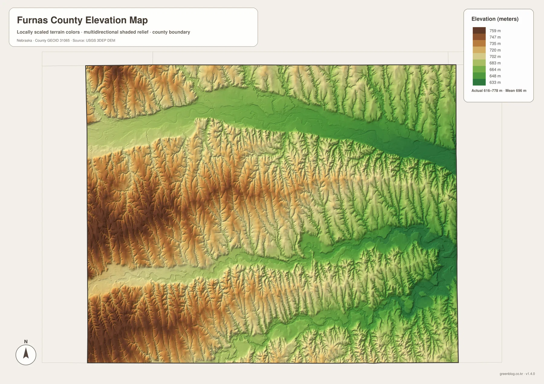
The elevation map reports an actual county-wide range of approximately 616 to 778 meters, with a mean near 696 meters. The highest brown terrain is concentrated across the west and southwest, while greens become more common toward the east. Total relief is about 162 meters.
Republican River forms the broadest low green corridor across the northern third of the county. Tributaries descending from both sides create narrow branches into the surrounding higher terrain, while the river floor itself remains relatively continuous. Cambridge and Arapahoe occupy this lower northern setting.
Beaver Creek creates another obvious low corridor across the south. Sappa Creek and related eastern drainage extend the lower terrain toward the southeastern side. Western and southwestern uplands remain distinctly higher, although numerous small tributaries cut that high surface into close-spaced ridges and valleys.
The elevation colors are scaled locally for Furnas County and should be used to compare locations within this map. Similar shades on another county map may represent different absolute heights. The generalized surface is not survey-grade information for engineering, construction, drainage design, or property work.
A snowstorm helped trigger the 1873 county-seat dispute
Furnas County’s official history describes a highly contested first organization election on April 8, 1873. Ballots were cast in both Arapahoe and Beaver City, but a severe snowstorm delayed Beaver City’s returns on the trip to Lincoln. Because those ballots missed the initial counting deadline, Arapahoe was first declared the county seat.
Court orders later required officials to count the Beaver City votes, and a second election was held in October. Beaver City won that contest, but legal challenges continued for roughly three years before the dispute was finally settled in its favor. The conflict delayed construction of a permanent courthouse for years.
Arapahoe and Cambridge developed along the Republican transport corridor
Arapahoe was established in 1871 and became the site of the county’s first post office in 1872. Furnas County planning records describe it as the place where U.S. 6-34 and U.S. 283 meet, a location that still makes the town one of the county’s clearest transportation junctions.
Cambridge anchors the western end of the same broad river corridor. History Nebraska’s place-name records say its post office name was changed from Medicine Creek to Cambridge in 1880. Today it remains the largest ranked community on the supplied city map and a practical reference for the western Republican River valley.
Use Republican River and Beaver City as two simple map anchors
For basic orientation, follow the northern U.S. 34-6 corridor through Cambridge, Holbrook, Arapahoe, and Edison, then use U.S. 136 to locate Oxford near the eastern edge. From there, move south to Beaver City and Route 46 to understand the relationship between the northern population belt and the inland county seat.
For physical geography, start with Republican River and trace Bear, Muddy, Dry, and Turkey creeks into the northern uplands. Then move south to Beaver Creek and Sappa Creek. The elevation map explains the same pattern with high brown terrain in the west and lower green valleys toward the east and along the major drainages.
For printing or classroom display, the downloadable high-resolution JPG files preserve more road numbers, creek names, canal labels, and local relief detail than the web previews. The county map emphasizes roads and settlements, the city map summarizes six ranked communities, the water map shows the two major drainage corridors, and the elevation map highlights the west-to-east height change.
Frequently Asked Questions
Does the city map show the distance between Cambridge and Beaver City?
No. The supplied city map ranks and locates Cambridge, Arapahoe, Oxford, Beaver City, Holbrook, and Edison, but it does not include connector lines or mileage. Use the road map for relative position and a current routing service when actual driving distance is needed.
Where is the lowest terrain in Furnas County?
The Republican River corridor and major eastern and southern creek valleys contain the lowest terrain. The mapped elevation range is about 616 to 778 meters, with the highest ground concentrated toward the west and southwest. Beaver Creek also forms a long low valley through the southern county.
Why is Beaver City the county seat instead of Arapahoe?
The first 1873 election became disputed after a snowstorm delayed Beaver City’s ballots. Courts ordered the votes to be counted, another election was held, and legal challenges continued until Beaver City was ultimately confirmed as the permanent county seat.
Map File Information
The ZIP contains the original high-resolution JPG files for the Furnas County boundary and road map, city distribution map, terrain and water map, and elevation map.
- Included Files: Use only the versions confirmed in the article and supplied images
- File Type: Use the confirmed download contents
- Intended Use: Printing, education, presentations, and map-based projects
Related Maps
Sources and references
- Furnas County – About Our County
- History Nebraska – Furnas County Records
- Nebraska Association of County Officials – Furnas County
- U.S. Census Bureau TIGER/Line Shapefiles
- USGS National Hydrography
- USGS 3D Elevation Program
These maps are intended for geographic reference. For legal boundaries, land ownership, flood determinations, water rights, road conditions, construction, surveying, or other decisions requiring current authoritative information, consult Furnas County and the responsible state or federal agency.
Green Map creates custom-edited map images using open geographic data sources such as geoBoundaries, Natural Earth, OpenStreetMap, and government open data. These maps are edited visual materials, not raw data files, and are provided for education, documents, presentations, and graphic reference.