Custer County occupies a broad section of central Nebraska, with Broken Bow near the middle and a landscape that changes noticeably from west to east. Higher rolling country and the edge of the Sandhills dominate much of the west and northwest, while the Middle Loup and South Loup river systems cut lower valleys across the eastern and southern interior. Arnold, Callaway, Sargent, Merna, and Ansley sit far enough apart to emphasize just how large the county is. High-resolution map files are available for download in the section below.
This page explains the major towns and roads, the distribution of six principal communities, the Loup River drainage and named creeks, and an elevation range of about 657 to 956 meters. The original high-resolution JPG versions of the supplied maps can also be downloaded together in a ZIP for printing, classroom use, or personal reference.
Table of Contents
Broken Bow provides a central reference in a 2,500-square-mile county
Broken Bow is the Custer County seat and the easiest place to start reading the map. The county’s official profile reports about 2,576 square miles of land and identifies Broken Bow as its largest community and county seat. On the supplied map, Broken Bow sits close to the center, making it a useful reference for Arnold to the west, Callaway to the southwest, Ansley to the southeast, Sargent to the northeast, and Merna to the north.
The settlements are widely dispersed rather than concentrated along one short corridor. Arnold lies near the western edge, Callaway occupies the southwest, and Sargent is far to the northeast. Long stretches of farm and ranch country separate the towns, with numerous small creeks and local roads filling the spaces between them.
The Nebraska Association of County Officials describes roughly the northwestern quarter of Custer County as part of the Sandhills, while much of the remainder belongs to Nebraska’s major agricultural belt. That division is visible in the maps: the northwest and west have broad rolling ridges, while the eastern side is increasingly dissected by Loup River tributaries.
Routes 70 and 21 make Broken Bow the road-network pivot
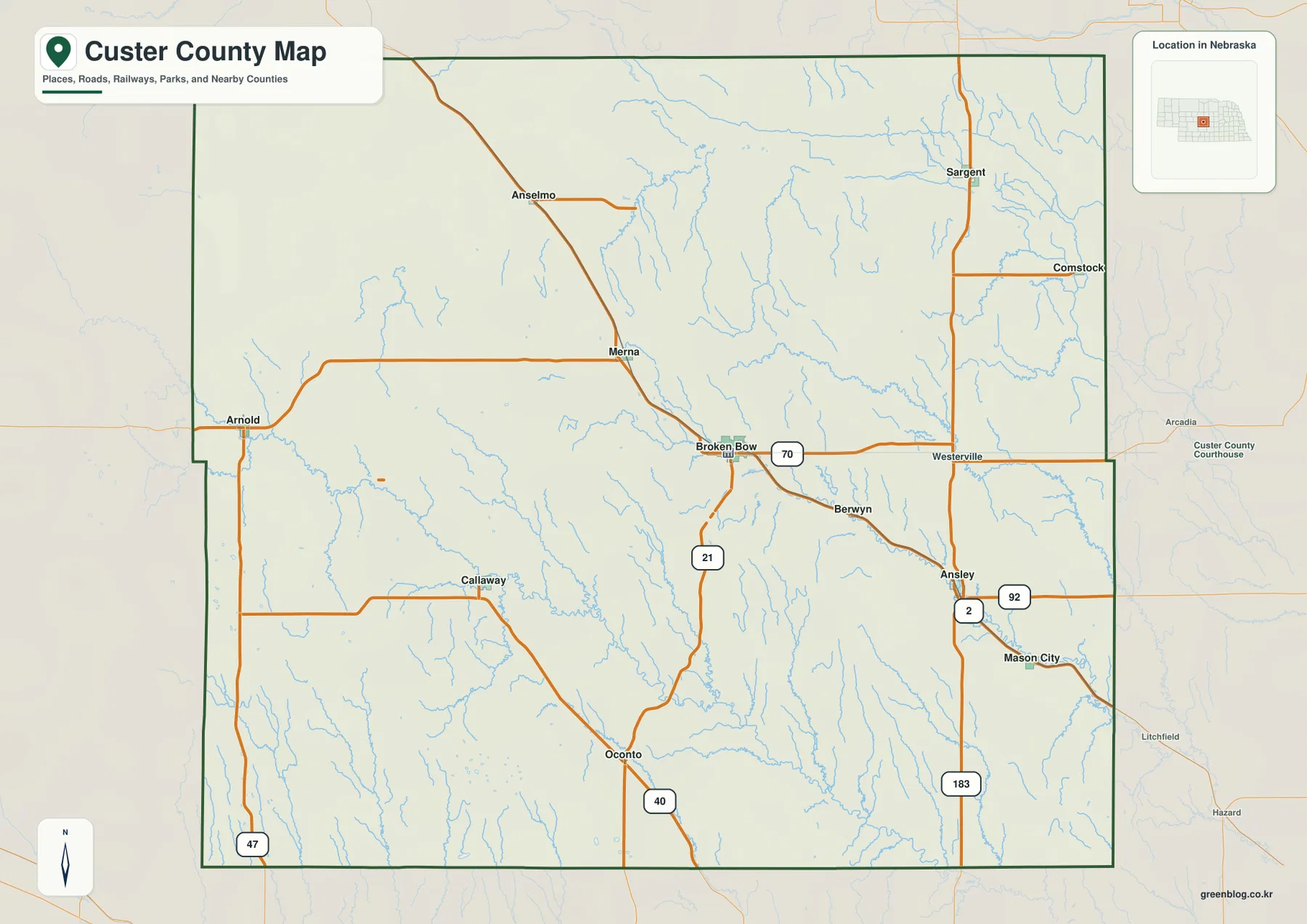
Route 70 is the clearest east-west reference through the central part of the county. It passes Broken Bow and continues toward Westerville, while roads northwest of the county seat connect toward Merna and Anselmo. Route 21 drops south from Broken Bow toward Oconto, giving the center of the county a strong north-south connection as well.
On the eastern side, routes marked 2 and 92 appear around Ansley, and U.S. 183 runs north-south through the same general region. Sargent is tied to the northeastern road system, while Route 40 appears near Oconto in the south-central area. Route 47 is visible along the western side and helps orient the Arnold and Callaway portions of the county.
The road grid is not equally simple everywhere. Central and eastern Custer County contain many stream valleys that break up straight local-road patterns, while the western uplands have longer open stretches. The general map is useful for orientation, but current construction, unpaved segments, closures, and travel times should be checked with live Nebraska transportation information.
Six ranked communities show how widely settlement is spread
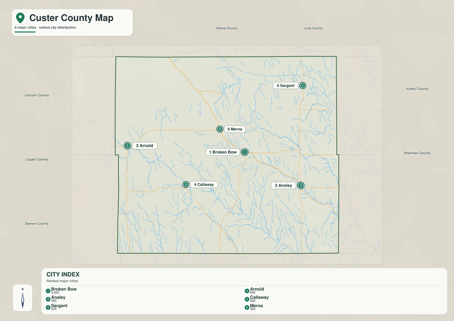
The city distribution map ranks Broken Bow first, followed by Arnold, Ansley, Callaway, Sargent, and Merna. Arnold is west, Callaway southwest, Sargent northeast, Merna north of the county seat, and Ansley southeast. The six markers span much of the county and make the scale of Custer County obvious even without mileage labels.
No straight-line connectors or distance labels appear on the supplied city map. The useful comparison is therefore positional rather than numerical. In a county this large, the road map is a better guide for practical travel because streams, local road alignments, and the limited number of major highways can make driving routes considerably different from a direct line.
The values printed on the supplied city map are 3,502 for Broken Bow, 945 for Arnold, 563 for Ansley, 562 for Callaway, 534 for Sargent, and 383 for Merna. Those numbers belong to the supplied ranked-city graphic and may use a different reference year from the county’s current demographic page. Current population figures should be checked with the Census Bureau or county sources when needed.
Middle Loup and South Loup carve two major drainage corridors
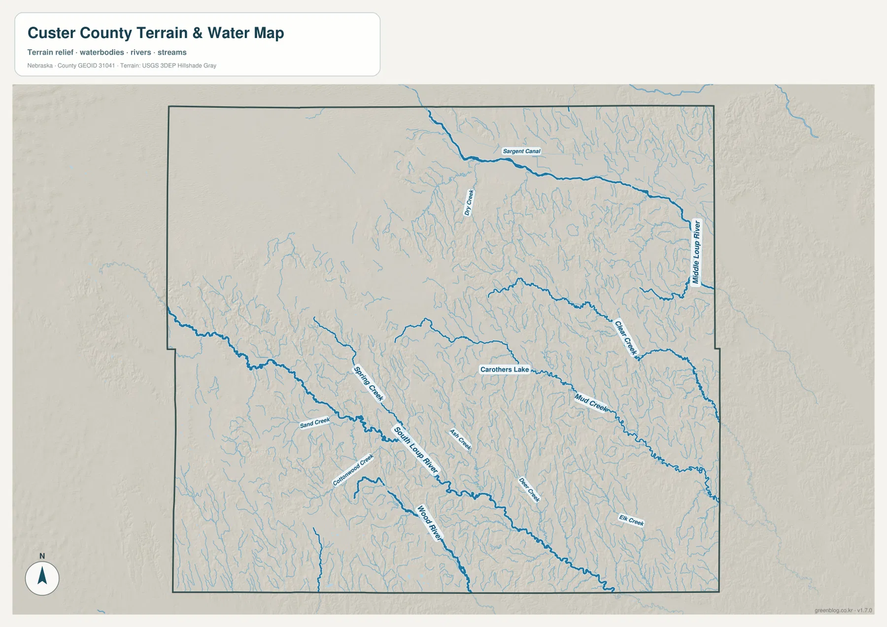
Middle Loup River is the strongest water feature in the northeast. It follows the eastern side of the county through a broad lower valley, with Sargent Canal and Dry Creek visible around the upper part of the drainage. Numerous short tributaries descend toward the river, giving the northeastern terrain a densely dissected appearance.
South Loup River crosses the lower middle of Custer County on a long southeastward course. Spring Creek, Sand Creek, Cottonwood Creek, Ash Creek, and Bear Creek descend from surrounding higher ground toward this valley. The Callaway and Oconto area is especially useful for seeing how roads and settlements relate to the South Loup drainage.
Clear Creek and Mud Creek form additional long valleys in the east, with Elk Creek farther southeast. Wood River is another pronounced stream in the south-central county, and Carothers Lake provides a small standing-water reference in the central-east. Together, these features show that Custer County is divided by many valleys rather than being one continuous flat plain.
This water map is intended for geographic reference. It does not define flood zones, legal water rights, parcel boundaries, channel depth, navigability, or public access. Those questions require current information from USGS and the appropriate local or state agencies.
Nearly 300 meters separate the eastern river valleys from western high ground
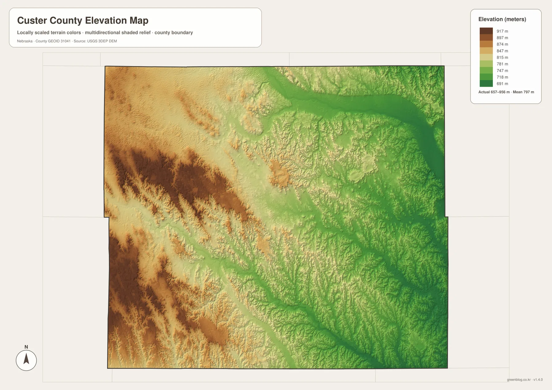
The elevation map reports an actual county-wide range of approximately 657 to 956 meters, with a mean near 797 meters. Browns and tans dominate the west and southwest, while greens become increasingly common toward the east. The county therefore loses almost 300 meters of elevation from its highest western terrain to its lowest river corridors.
The Middle Loup valley forms a broad green lowland in the northeast and along the eastern edge. South Loup River creates another long lower route across the south-central county, with multiple tributaries cutting down from the surrounding uplands. These two river systems are the clearest organizing features on the elevation map.
Western and southwestern Custer County contains repeated ridges and higher rolling terrain. It is not a single mountain block; instead, creeks cut long valleys between upland surfaces. The northwestern Sandhills side has broader rolling forms, while the eastern side is more tightly dissected by tributaries approaching the Loup rivers.
The elevation colors are scaled locally for Custer County and are intended for comparison within this map. Similar shades on another county map may represent different absolute heights. The generalized surface is not survey-grade information for engineering, construction, drainage design, or property work.
Custer County began as open cattle country before homesteads spread
History Nebraska records that Custer County was outlined by the Legislature in 1877 and officially organized that June. The county’s own history says cattlemen were already driving large herds into the area by 1869. By 1880, roughly 60,000 cattle were reported on the open range.
That ranching era changed quickly as homesteaders arrived and the severe winter of 1880-1881 caused major cattle losses. Farms and small settlements replaced much of the open range. The contrast between broad western ranch country and more intensively settled central and eastern areas still helps explain the county’s present landscape.
Broken Bow became the county seat as rail settlement accelerated
History Nebraska says Broken Bow was platted in June 1882 and won the county-seat election in January 1883. Before that election, county records had been kept at temporary locations and in officials’ homes. Broken Bow’s near-central location made it a practical administrative center for such a large county.
Railroad construction in the 1880s also accelerated permanent settlement. A Nebraska historic-building survey notes that new rail lines connected Custer County communities with eastern markets and helped townsites grow. The modern road and settlement map still concentrates important routes around Broken Bow and the east-central corridor.
Using the four Custer County map views together
For basic orientation, start with Broken Bow and Routes 70 and 21, then move west to Arnold and Merna, southwest to Callaway, east to Ansley, and northeast to Sargent. The city map provides a simpler view of the same six principal communities when minor roads are not needed.
For physical geography, compare Middle Loup River in the northeast with South Loup River farther south. Clear Creek, Mud Creek, Spring Creek, and Wood River help fill in the interior drainage network, while the elevation map explains the broad transition from higher western uplands to lower eastern river country.
For printing or classroom display, the downloadable high-resolution JPG files preserve more road labels and creek detail than the web previews. The county map emphasizes settlements and roads, the city map summarizes the ranked communities, the water map identifies the Loup drainage, and the elevation map highlights the strong west-to-east relief change.
Frequently Asked Questions
Does the city map show distances from Broken Bow to Arnold or Ansley?
No. The supplied city map ranks and locates Broken Bow, Arnold, Ansley, Callaway, Sargent, and Merna, but it does not include connector lines or mileage. Because Custer County is very large, current road routing is the better source for actual driving distance and travel time.
Where is the lowest terrain in Custer County?
The Middle Loup River valley in the east and northeast contains some of the lowest terrain, with the South Loup corridor forming another long low route farther south. The county-wide elevation range is about 657 to 956 meters, and higher ground becomes more common toward the west and southwest.
How does the northwest differ from the eastern side?
The northwest transitions into broader Sandhills-style rolling terrain and is generally higher. The east is more deeply cut by Middle Loup River and dense tributary valleys. The difference is easiest to see by comparing the water and elevation maps together.
Map File Information
The ZIP contains the original high-resolution JPG files for the Custer County boundary and road map, city distribution map, terrain and water map, and elevation map.
- Included Files: Use only the versions confirmed in the article and supplied images
- File Type: Use the confirmed download contents
- Intended Use: Printing, education, presentations, and map-based projects
Related Maps
Sources and references
- Custer County – About Our County
- History Nebraska – Custer County Historical Note
- History Nebraska – Custer County’s First Courthouse
- Nebraska Association of County Officials – Custer County
- USGS National Hydrography
- USGS 3D Elevation Program
These maps are intended for geographic reference. For legal boundaries, land ownership, flood determinations, water rights, road conditions, construction, surveying, or other decisions requiring current authoritative information, consult Custer County and the responsible state or federal agency.
Green Map creates custom-edited map images using open geographic data sources such as geoBoundaries, Natural Earth, OpenStreetMap, and government open data. These maps are edited visual materials, not raw data files, and are provided for education, documents, presentations, and graphic reference.