Clay County lies in south-central Nebraska, with Clay Center near the middle and Sutton, Harvard, Fairfield, and Edgar distributed around a broad agricultural landscape. West Fork Big Blue River bends through the northwest, Little Blue River clips the southwest, and several long creeks cross the interior. Elevation is modest overall, but the west and northwest sit noticeably higher than the eastern side. High-resolution map files are available for download in the section below.
This page explains the county roads and settlements, the ranked distribution of six major communities, the Big Blue and Little Blue drainage systems, and an elevation range of about 496 to 581 meters. The original high-resolution JPG versions of the supplied maps are also available together in a ZIP for printing, classroom use, or personal reference.
Table of Contents
Clay Center gives the county a genuinely central reference point
Clay Center is the county seat and sits close to the middle of the county. Clay County’s official website lists Clay Center, Sutton, Harvard, Edgar, Fairfield, Trumbull, Glenvil, Ong, Saronville, and Deweese among its current communities. On the general map, Clay Center is easy to use as a reference between the larger northern towns and the smaller southern communities.
History Nebraska records that the present county boundaries were established in 1867 and that an election for county organization was authorized in September 1871. Sutton became the first county seat, but Harvard, Fairfield, Sutton, and Clay Center competed for the permanent location. A 1879 election eventually fixed the seat at Clay Center, where it remains.
The county was named for Henry Clay, the Kentucky statesman and U.S. Secretary of State. The official county history notes that settlement began in the late 1850s and expanded sharply after railroads arrived in the 1870s. The modern road and rail map still reflects that agricultural transportation history.
U.S. 6 organizes the north while Route 14 runs through Clay Center
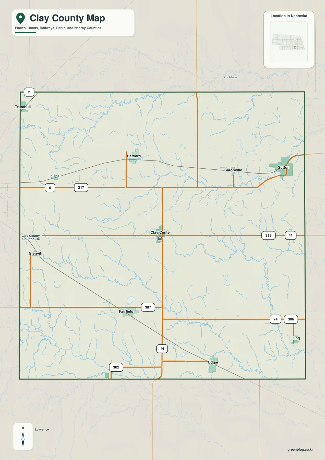
U.S. 6 is the clearest east-west road in the northern half. It runs south of Harvard and continues toward Sutton, keeping two of the county’s largest communities on one broad transportation line. Route 317 appears near the western part of the same corridor, while Sutton sits close to the eastern edge.
Route 14 crosses the county through Clay Center and continues south toward Edgar. Roads marked 313 and 41 serve the east-central side, while 307 and 302 help organize the Fairfield and Edgar area. Near Ong in the southeast, routes 74 and 306 provide additional local references, and Route 2 appears near Trumbull at the northwest edge.
The communities are not concentrated along one single road, which makes Clay Center’s central location especially useful. Rail lines also cross several towns and reinforce the long-standing agricultural transport pattern. Current construction, closures, road surfaces, and travel times should still be checked with live Nebraska transportation information.
Six ranked communities show a dispersed settlement pattern
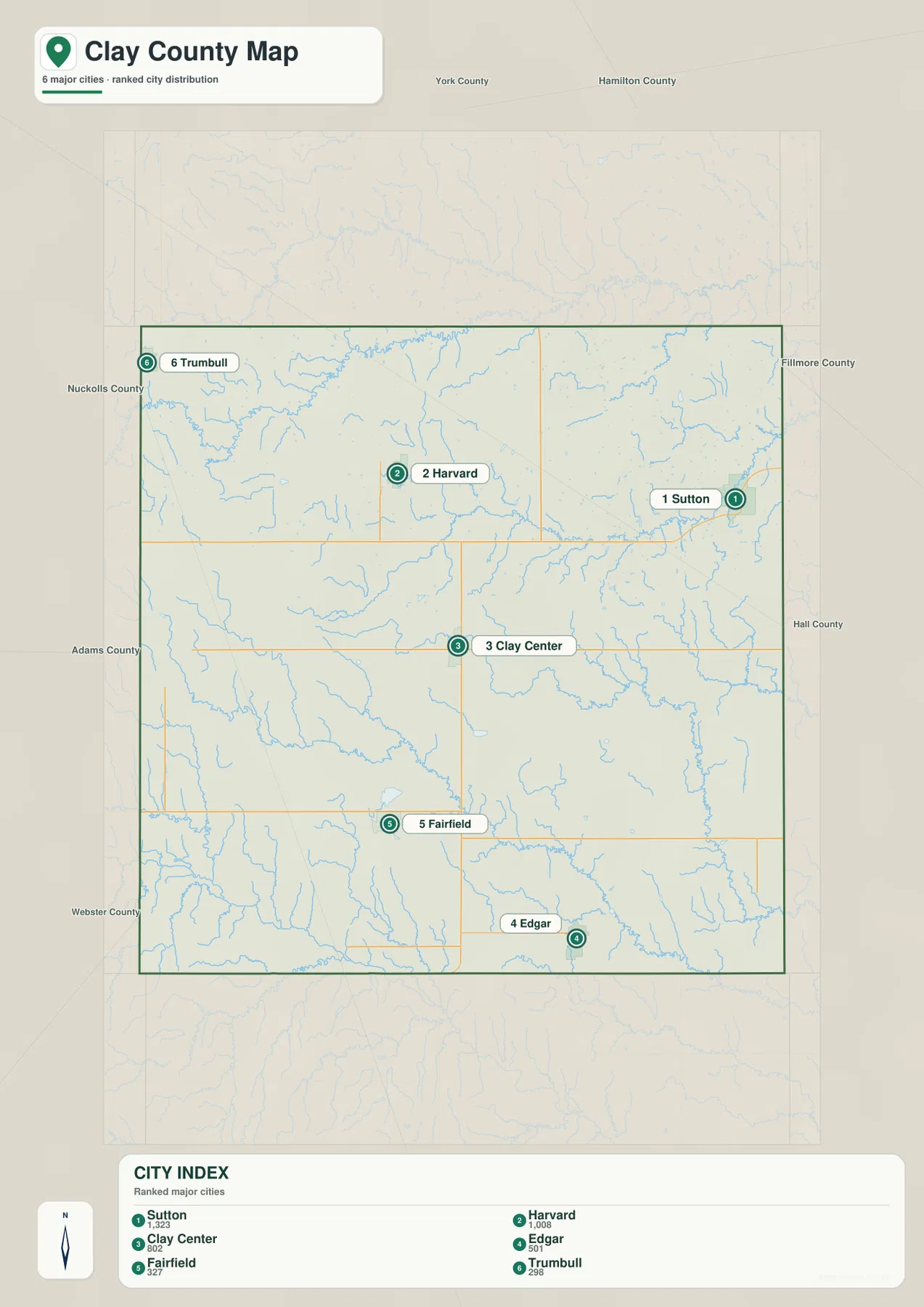
The city distribution map ranks Sutton first, Harvard second, and Clay Center third, followed by Edgar, Fairfield, and Trumbull. Sutton lies in the east, Harvard in the northwest, Clay Center near the middle, Fairfield and Edgar in the south, and Trumbull close to the northwestern boundary. The markers make it clear that the county’s larger communities are spread in several directions.
No connector lines or mileage labels appear on the supplied city map. The useful comparison is therefore positional rather than numerical. The road map is better for practical travel relationships, while the city view strips away smaller roads and shows the relative distribution of the six selected communities.
The values printed on the supplied map are 1,323 for Sutton, 1,008 for Harvard, 802 for Clay Center, 501 for Edgar, 327 for Fairfield, and 298 for Trumbull. These are part of the supplied ranked-city graphic rather than a continuously updated demographic table. Current population figures should be checked with the U.S. Census Bureau or county sources when needed.
Big Blue and Little Blue tributaries divide the county into several creek valleys
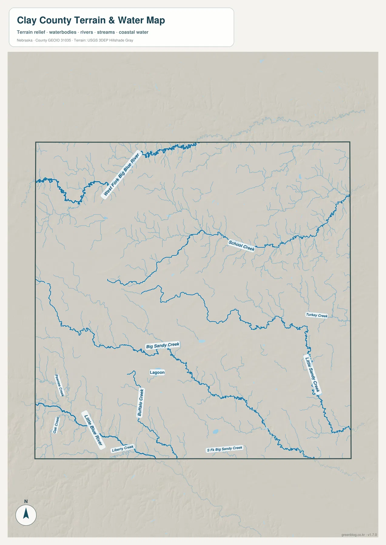
West Fork Big Blue River is the most prominent water feature in the northwest. It makes a broad bend through the upper part of the county, receiving short tributaries from surrounding higher ground. On the elevation map, the river valley appears as a lower green corridor cut into the western uplands.
Big Sandy Creek crosses the central-southern interior, while School Creek follows a long route through the north-central and eastern side. Turkey Creek and Little Sandy Creek occupy the east, and South Fork Big Sandy Creek appears close to the southern boundary. Together these streams create many shallow but distinct drainage valleys across the agricultural plain.
Little Blue River enters the southwest, accompanied by Buffalo Creek, Liberty Creek, Pawnee Creek, and Oak Creek. A small lagoon is also labeled in the south-central area. The map therefore shows two broad drainage contexts: the Big Blue system is more prominent in the northwest and center, while Little Blue tributaries are important in the southwest.
This water map is intended for geographic reference. It does not define flood zones, legal water rights, parcel boundaries, channel depth, navigability, or public access. Those questions require current information from USGS and the appropriate Nebraska or local agencies.
Elevation falls gently from the northwest toward the east and southeast
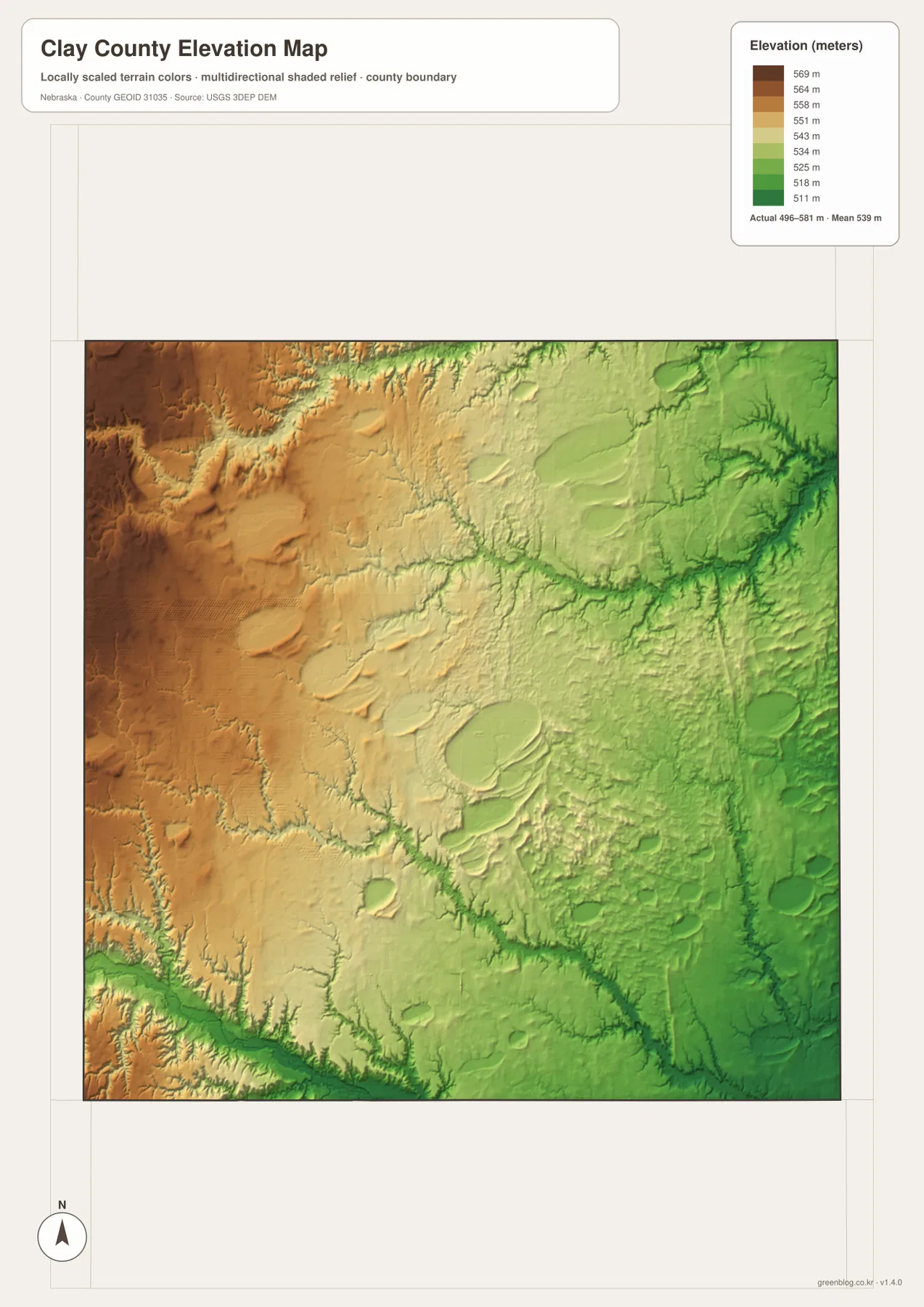
The elevation map reports an actual county-wide range of approximately 496 to 581 meters, with a mean near 539 meters. Browns and tans dominate the west and northwest, while greens become more common toward the east and southeast. The total difference is only about 85 meters, but the county-wide slope is easy to see at this scale.
West Fork Big Blue River cuts a lower corridor through the northern uplands. Big Sandy Creek, School Creek, and Little Blue River create additional low paths through the interior and southwest. Comparing the water and elevation maps shows how even a relatively gentle plains landscape is structured by stream valleys.
The western half includes broad, slightly higher surfaces broken by shallow drainages, while the east and southeast contain more low green terrain. Clay Center sits near the transition between those two zones, and Sutton lies farther into the lower eastern side. The pattern is gradual rather than dramatic, but it helps explain the direction of the main waterways.
The colors are scaled locally for Clay County and should be used to compare places within this map. Similar shades on another county map may represent different absolute elevations. The generalized surface is not survey-grade information for engineering, construction, drainage design, or property work.
The county-seat contest explains why Clay Center sits in the middle
Clay County’s early government was based in Sutton, but the location became the subject of repeated elections and intense rivalry. History Nebraska records that Sutton, Harvard, Fairfield, and Clay Center all competed for the permanent county seat. The 1879 vote finally placed the county government at Clay Center.
A Nebraska historical marker notes that Clay Center was laid out in the summer of 1879 and confirmed as the seat later that year. The town later developed agricultural industries, including a nationally known incubator factory, and during World War II a Naval Ammunition Depot was built just west of town. The property was later transferred to the U.S. Meat Animal Research Center.
Streams, rail lines, and agriculture shaped the dispersed towns
Clay County’s official profile describes a landscape dominated by agricultural land. Even so, the maps show meaningful local differences. West Fork Big Blue River, Big Sandy Creek, and Little Blue River cut shallow valleys through the farms, while rail lines and roads connect the towns across those drainage divides.
Sutton and Harvard developed as important northern communities, Fairfield and Edgar serve the southern side, and Clay Center remains the administrative center. Smaller places such as Trumbull and Glenvil sit close to road and rail connections. Viewing the city and road maps together makes the county’s spread-out rural settlement pattern much easier to understand.
Using the four Clay County map views together
For basic orientation, start with Clay Center and Route 14, then move north toward Harvard and Sutton or south toward Fairfield and Edgar. U.S. 6 provides the main east-west reference in the north, while roads 307 and 302 help organize the southern part of the county.
For physical geography, begin with West Fork Big Blue River in the northwest, then trace Big Sandy Creek across the center and Little Blue River in the southwest. The elevation map adds the vertical context by showing higher western ground and lower eastern terrain.
For printing or classroom display, the downloadable high-resolution JPG files preserve more road labels and creek detail than the web previews. The county map emphasizes roads and settlements, the city map summarizes six ranked communities, the water map identifies the drainage network, and the elevation map shows the gentle west-to-east drop.
Frequently Asked Questions
Does the city map show distances from Clay Center to Sutton or Harvard?
No. The supplied city map ranks and locates Sutton, Harvard, Clay Center, Edgar, Fairfield, and Trumbull, but it does not include connector lines or mileage. Use the general road map for relative position and a current routing service when actual driving distance is needed.
Where is the lowest terrain in Clay County?
The lowest terrain is generally found in the eastern and southeastern stream valleys. The county-wide elevation range is about 496 to 581 meters, with higher ground becoming more common toward the west and northwest.
Can the creek map be used for flood or property decisions?
No. It is a geographic reference showing West Fork Big Blue River, Big Sandy Creek, Little Blue River, School Creek, and other tributaries. Flood risk, water rights, parcel boundaries, channel conditions, and access questions require current authoritative records.
Map File Information
The ZIP contains the original high-resolution JPG files for the Clay County boundary and road map, city distribution map, terrain and water map, and elevation map.
- Included Files: Use only the versions confirmed in the article and supplied images
- File Type: Use the confirmed download contents
- Intended Use: Printing, education, presentations, and map-based projects
Related Maps
Sources and references
- Clay County – About Our County
- History Nebraska – Clay County Historical Note
- History Nebraska – Clay Center Historical Marker
- U.S. Census Bureau TIGER/Line Shapefiles
- USGS National Hydrography
- USGS 3D Elevation Program
These maps are intended for geographic reference. For legal boundaries, land ownership, flood determinations, water rights, road conditions, construction, surveying, or other decisions requiring current authoritative information, consult Clay County and the responsible state or federal agency.
Green Map creates custom-edited map images using open geographic data sources such as geoBoundaries, Natural Earth, OpenStreetMap, and government open data. These maps are edited visual materials, not raw data files, and are provided for education, documents, presentations, and graphic reference.