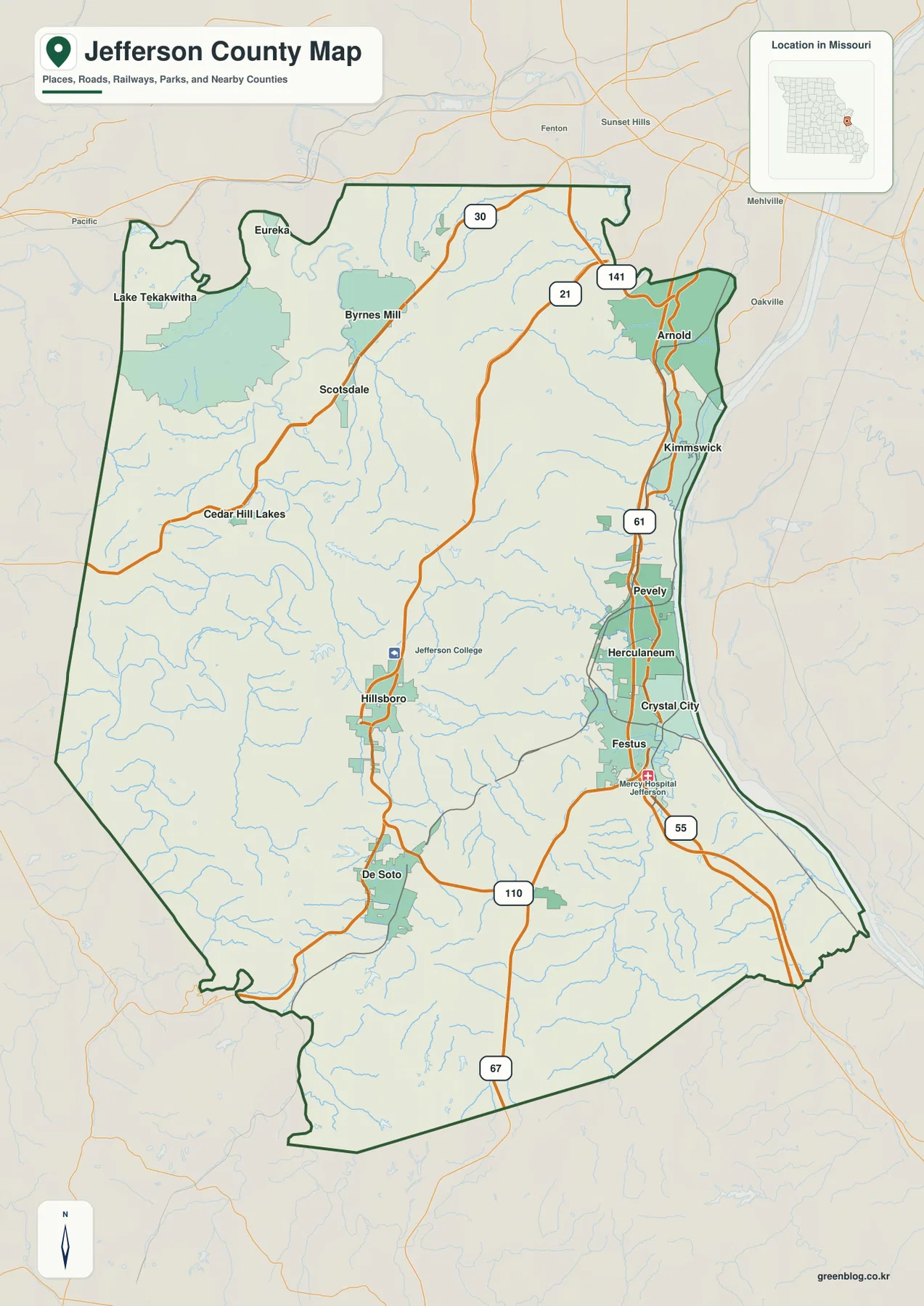
Jefferson County lies south of St. Louis in eastern Missouri, where suburban communities along the Mississippi River meet the deeply dissected hills of the Ozarks. Arnold anchors the northeast, while Kimmswick, Pevely, Herculaneum, Crystal City, and Festus follow the eastern side. Hillsboro and De Soto provide interior reference points, and streams such as Big River, Saline Creek, Rock Creek, Sandy Creek, and Plattin Creek cut long valleys through the uplands. The elevation layer spans roughly 84 to 321 meters. High-resolution JPG versions of the map themes are available together in the ZIP for printing or offline use. High-resolution map files are available for download in the section below.
The county changes quickly from east to west. Low Mississippi River terrain lies close to densely settled communities, but only a short distance inland the land rises into narrow ridges and branching creek valleys. Around Hillsboro, De Soto, and the western half, the terrain becomes much more strongly rolling. Comparing the city, water, and elevation layers makes that transition easier to see.
Table of Contents
Arnold to Festus forms the main eastern urban corridor
Arnold is the largest mapped city in the northeastern part of Jefferson County. Routes 141 and 21 and the U.S. 61 corridor provide strong road references, while the developed strip continues south through Kimmswick, Pevely, Herculaneum, Crystal City, and Festus. This eastern side is the county’s most continuous urban corridor and connects directly with the southern St. Louis metropolitan area.
Pevely, Herculaneum, Crystal City, and Festus sit close together along the Mississippi River side, although each has its own city limits. From Festus, major roads continue south and west toward the interior. The general map is intended for county-scale orientation rather than current traffic or turn-by-turn navigation.
Hillsboro and De Soto provide the main interior references
Hillsboro lies near the center of the county and functions as the administrative hub. Jefferson County’s official site lists the Administration Center and County Clerk at 729 Maple Street in Hillsboro. Route 21 passes through the area and links the interior with Arnold to the north and De Soto farther south. Jefferson College is also labeled just north of Hillsboro on the supplied map.
De Soto lies southwest of Hillsboro near Routes 21 and 110. Compared with the Mississippi River corridor, the De Soto area has a smaller urban footprint and much more immediate contact with ridges and stream valleys. The terrain becomes especially rugged toward the south and southwest, where the elevation map shows larger areas of tan and brown upland.
The city layer ranks six major communities
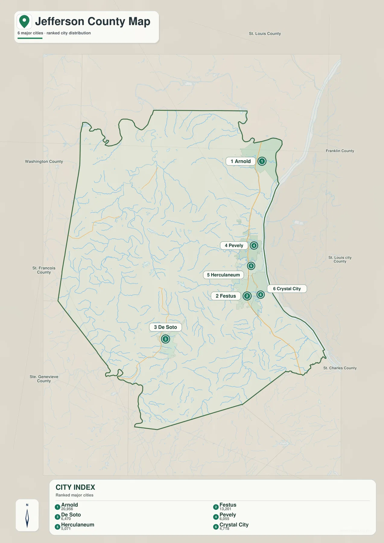
The ranked city map places Arnold first, Festus second, De Soto third, Pevely fourth, Herculaneum fifth, and Crystal City sixth. The CITY INDEX displays values of 20,956 for Arnold, 13,201 for Festus, 6,470 for De Soto, 6,055 for Pevely, 5,071 for Herculaneum, and 4,718 for Crystal City. These values belong to the supplied map dataset and should not be treated as current official population estimates.
The geographic pattern matters more than the raw numbers. Arnold stands apart in the northeast, while Festus, Pevely, Herculaneum, and Crystal City cluster along the eastern river corridor. De Soto lies inland to the southwest in a different terrain setting. The numbered markers represent ranking rather than road mileage or travel time.
The Mississippi River creates the county’s lowest eastern corridor
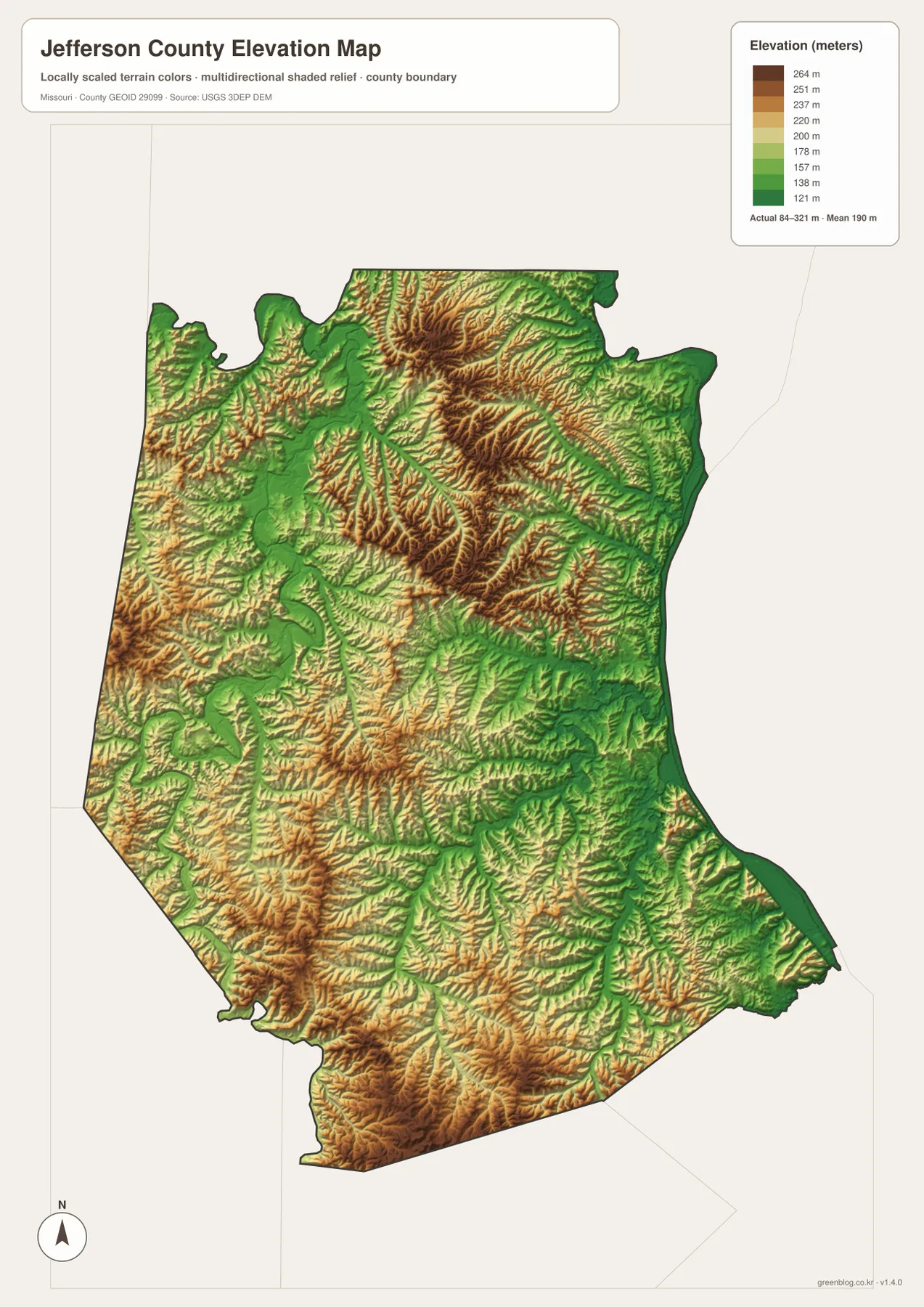
The Mississippi River follows the eastern edge of Jefferson County. From the Arnold and Kimmswick side south toward Pevely, Herculaneum, Crystal City, and Festus, the river lowland forms a long lower corridor. On the elevation map, this edge appears in dark green and contrasts sharply with the higher interior hills.
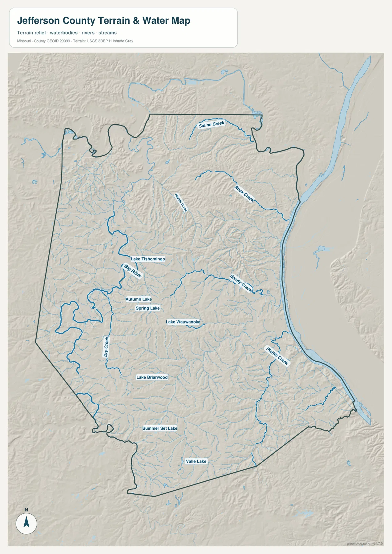
Several tributaries descend from the uplands toward the Mississippi. Rock Creek, Sandy Creek, and Plattin Creek create narrow valleys that cut through the rising terrain west of the river. The change can be rapid: moving only a short distance inland from the floodplain brings the map into much higher and more irregular ground.
Big River cuts a deep interior valley through the western half
Big River is the dominant inland watercourse on the terrain-and-water map. It winds through western and central Jefferson County and creates a broad low valley between higher ridges. Missouri Department of Conservation describes the Big River as a major Ozark Plateau watershed that flows north toward the Meramec River and includes recreational access points within Jefferson County.
Lake Tishomingo, Autumn Lake, and Spring Lake are among the named water bodies near the Big River side of the county. Dry Creek forms another distinct drainage farther southwest, and many short tributaries join the larger valleys. On the elevation layer, the Big River corridor is easy to follow as a long green route through tan and brown hills.
Saline Creek, Rock Creek, and Sandy Creek divide the northern and eastern hills
Saline Creek runs across the northern interior, while Rock Creek descends through the northeastern hills toward the Mississippi River. Those valleys break up what might otherwise look like a broad suburban upland on the general road map. Numerous short tributaries create tightly spaced ridges between the main channels.
Sandy Creek crosses the east-central part of the county west of the Mississippi corridor. Its valley provides a natural transition between the Pevely–Festus side and the higher country around Hillsboro. The terrain-and-water map is meant for geographic reference; current water levels, flood conditions, and legal water boundaries require separate official information.
Plattin Creek and small lakes add detail to the southern landscape
Plattin Creek is a major named tributary in southeastern Jefferson County and drains toward the Mississippi River. South of Festus and Crystal City, the creek and its branches cross a landscape that shifts between lower green valleys and much higher ridges farther west.
The water map also labels Lake Wauwonoka, Lake Briarwood, Summer Set Lake, Valle Lake, and several other small water bodies. These lakes are not county-wide drainage features like the Mississippi or Big River, but they are useful landmarks for matching rural areas between the road, water, and elevation layers.
Elevation ranges from about 84 to 321 meters
The elevation map reports an actual mapped range of approximately 84 to 321 meters, with a mean near 190 meters. The lowest ground follows the Mississippi River and the larger stream valleys. Much higher terrain appears across the north-central interior, southwest, and southern edge, where brown and dark tan ridges dominate.
Jefferson County’s relief comes from a dense network of streams cutting into the uplands rather than from one isolated mountain. West of Hillsboro and south of De Soto, narrow ridges and valleys repeat across the landscape. Even near the eastern cities, Rock Creek and Sandy Creek produce sharp local elevation changes. The map is suitable for county-scale terrain comparison but not survey-grade or engineering-grade measurements.
Kimmswick connects the river corridor with Mastodon State Historic Site
Kimmswick is a small city south of Arnold near the Mississippi River, and the nearby Mastodon State Historic Site gives this part of Jefferson County unusual archaeological and paleontological significance. Missouri State Parks states that the Kimmswick Bone Bed produced strong evidence that humans and American mastodons coexisted in eastern North America.
The site includes a museum, exhibits, and trails related to the bone bed and prehistoric Missouri. On the county map, Kimmswick sits within the narrow eastern corridor where the river lowland meets rising hills. Visitors should check the current Missouri State Parks page for museum hours, temporary closures, and trail information before traveling.
Sandy Creek Covered Bridge adds another Hillsboro-area landmark
Missouri State Parks lists Sandy Creek Covered Bridge State Historic Site in Hillsboro. The location provides a useful historical reference near the county’s central administrative area and also connects directly with the Sandy Creek name visible on the water map.
The supplied county map is not a dedicated attraction map, so it should not be used to pinpoint parking or trail access. For a visit, the state park’s current location and operating information should be used. As a geographic reference, however, the bridge site helps connect local history with one of the county’s prominent creek valleys.
Choosing the right downloadable map
Use the general county map for Arnold, Festus, Hillsboro, De Soto, and the major road network. The ranked city map is best for comparing the six leading communities. The terrain-and-water layer is useful for the Mississippi River, Big River, Saline Creek, Sandy Creek, and local lakes, while the elevation map makes the difference between the eastern lowland and the central and southwestern hills much clearer.
The download ZIP contains high-resolution JPG versions of the same map themes shown on the page. They are useful for enlarging labels, printing a reference sheet, or comparing layers side by side. The files are intended for general geographic reference and do not replace live navigation, flood warnings, legal boundary surveys, or professional elevation measurements.
Frequently Asked Questions
What are the best places to use as reference points in Jefferson County?
Arnold and Festus are useful for the eastern urban corridor, Hillsboro is the central administrative reference, and De Soto is a good anchor for the hillier southwestern interior.
Are the numbers on the city map current population counts?
They should not be treated as current official population estimates. The values beside Arnold, Festus, De Soto, Pevely, Herculaneum, and Crystal City belong to the supplied CITY INDEX dataset, while the numbered markers indicate rank.
What elevation range does the Jefferson County map show?
The elevation layer shows an actual range of about 84 to 321 meters, with a mean near 190 meters. The Mississippi River and major stream valleys are lowest, while the interior and southern ridges rise much higher.
Map File Information
Download the map files associated with this page for reference, printing, and compatible visual projects.
- Included Files: Use only the versions confirmed in the article and supplied images
- File Type: Use the confirmed download contents
- Intended Use: Printing, education, presentations, and map-based projects
Related Maps
Sources and references
- Jefferson County, Missouri – Official Website – county government and public services in Hillsboro
- Missouri State Parks – Mastodon State Historic Site – Kimmswick Bone Bed and local natural history
- Missouri Department of Conservation – Big River – official Big River watershed information
- Missouri State Parks – Sandy Creek Covered Bridge location – Hillsboro historic-site reference
- U.S. Census Bureau TIGER/Line Shapefiles – county boundary and road data
- USGS National Hydrography – rivers, streams, and water features
- USGS 3D Elevation Program – elevation data
Green Map creates custom-edited map images using open geographic data sources such as geoBoundaries, Natural Earth, OpenStreetMap, and government open data. These maps are edited visual materials, not raw data files, and are provided for education, documents, presentations, and graphic reference.