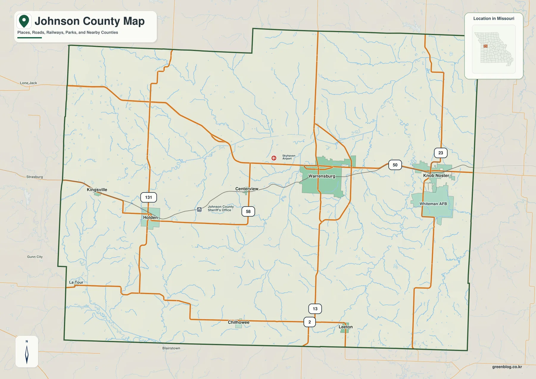
Johnson County lies in west-central Missouri, with Warrensburg as its largest city and main road reference. Knob Noster and Whiteman Air Force Base anchor the east, while Holden, Kingsville, Centerview, Chilhowee, and Leeton spread across the western and southern parts of the county. U.S. 50 crosses the center from west to east, Route 13 runs through Warrensburg, and the Blackwater River system creates a broad network of low valleys. The elevation layer spans approximately 200 to 330 meters. High-resolution JPG versions of the map themes are available together in the download ZIP for printing or offline reference.
The county is not simply a flat agricultural block. Higher ridges are more prominent along the western edge and in the southeast, while North Fork and South Fork Blackwater River feed a lower central corridor that continues east. The road, city, water, and elevation layers together show how Warrensburg, Knob Noster, and the smaller towns sit within that changing terrain.
Table of Contents
Warrensburg and U.S. 50 form the county’s main reference
Warrensburg is the most prominent city on the general map and sits slightly east of the county center. U.S. 50 runs through the city from west to east, linking Holden-side routes with Knob Noster, while Route 13 provides the major north-south reference. Skyhaven Airport is labeled west of town, adding another useful landmark for orientation.
Johnson County’s official website places many county offices in Warrensburg, including temporary offices used while the courthouse is being remodeled. That administrative concentration matches the map: Warrensburg is the clearest central reference for roads, services, and the surrounding smaller communities.
Knob Noster and Whiteman AFB define the eastern side
Following U.S. 50 east from Warrensburg leads to Knob Noster, with Whiteman Air Force Base immediately to the south. Route 23 provides the strongest north-south road reference on this side of the county. The urban and military footprint is easy to spot on the general map, but the surrounding area still contains many small streams and open rural tracts.
Missouri Department of Natural Resources describes Whiteman AFB as being in Johnson County about nine miles east of Warrensburg and identifies it as the home of the 509th Bomb Wing. The county map should be used only for general geographic orientation; it is not intended to show internal base details or operational information.
Holden, Kingsville, and Centerview organize the western road network
Holden lies in the west-central part of Johnson County near the intersection of Route 58 and Route 131. Kingsville is farther northwest, while Centerview sits between Holden and Warrensburg. Route 58 makes the east-west relationship among these western communities especially easy to follow.
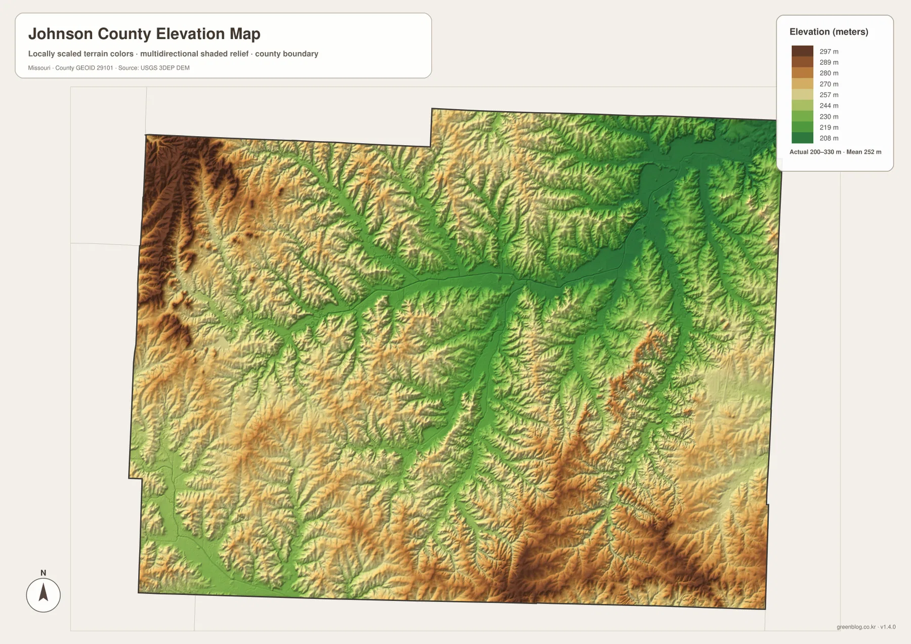
The western edge has fewer dense urban areas than Warrensburg and contains more closely spaced creek valleys. On the elevation map, the northwest and far west include some of the highest brown terrain in the county. Comparing Holden and Kingsville across the water and elevation layers makes the rolling landscape much more obvious than it appears on the road map alone.
The city layer ranks six major communities
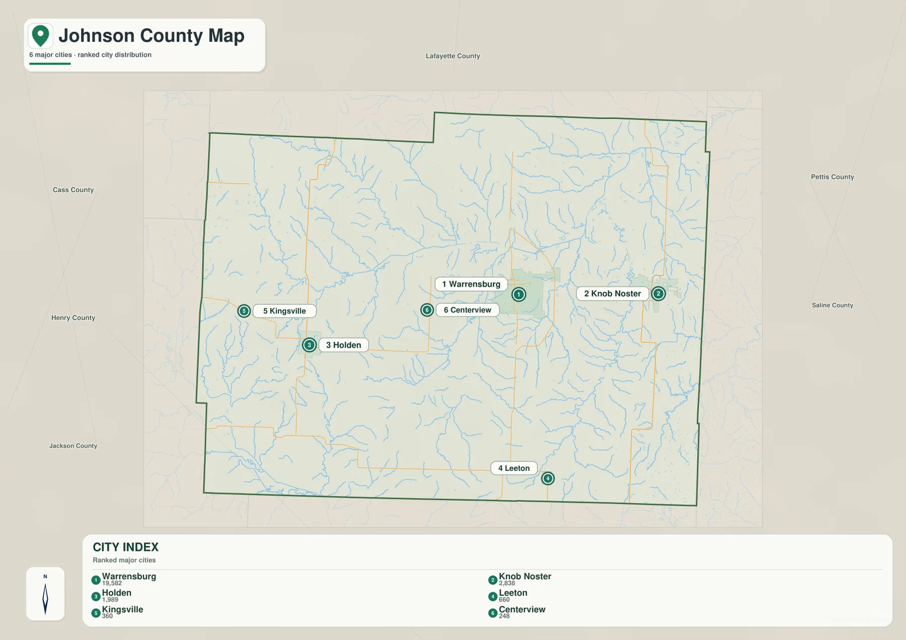
The ranked city map places Warrensburg first, Knob Noster second, Holden third, Leeton fourth, Kingsville fifth, and Centerview sixth. The CITY INDEX shows values of 19,582 for Warrensburg, 2,838 for Knob Noster, 1,989 for Holden, 660 for Leeton, 360 for Kingsville, and 248 for Centerview. These values belong to the supplied map dataset and should not be treated as current official population estimates.
The spatial pattern matters more than the raw numbers. Warrensburg occupies the central-east, Knob Noster lies farther east, Holden and Kingsville are west, Leeton is south, and Centerview sits west of Warrensburg. The numbered markers indicate rank rather than road mileage or travel time.
The Blackwater River system creates a broad central lowland
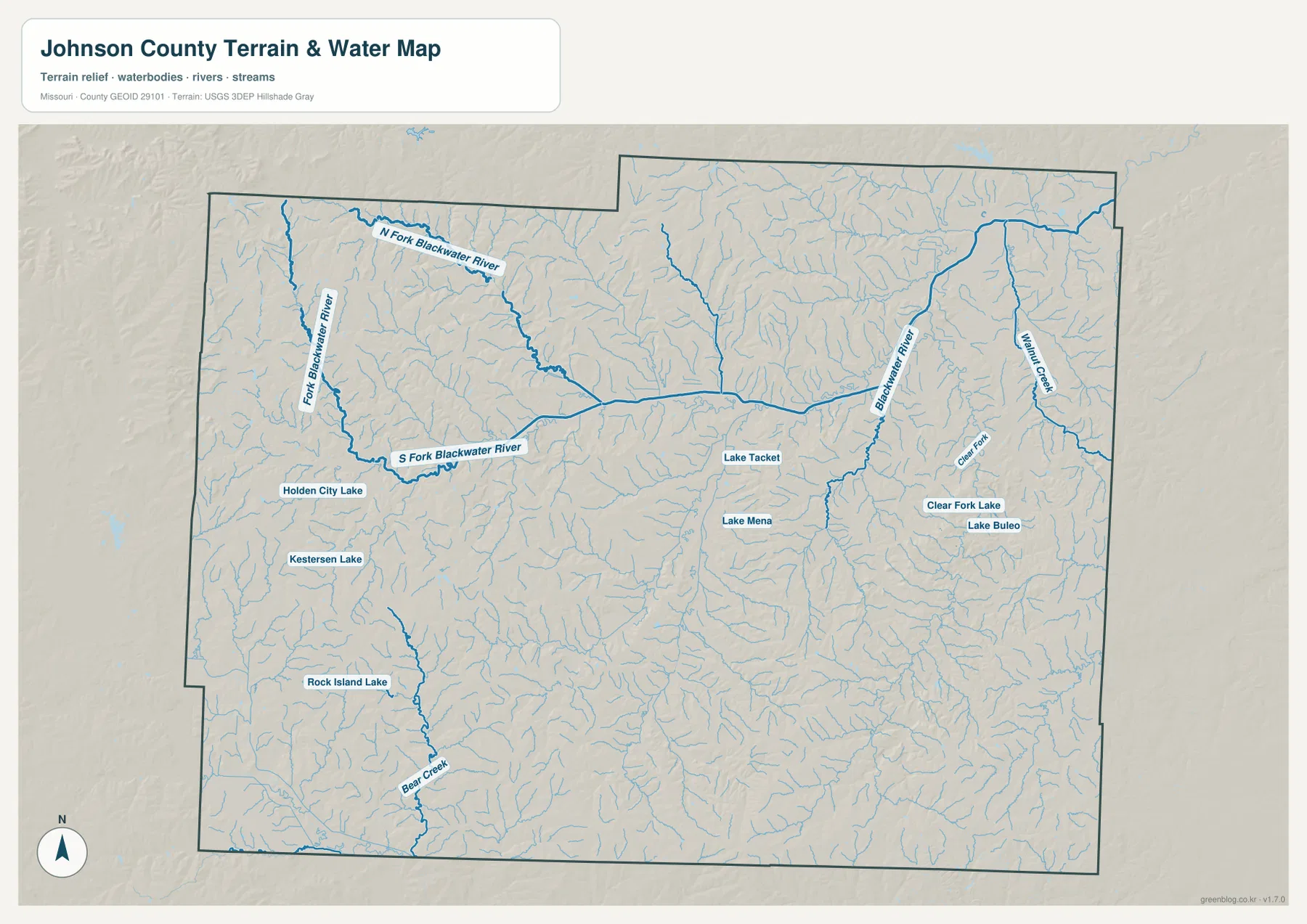
The terrain-and-water map is dominated by the Blackwater River system. North Fork Blackwater River and South Fork Blackwater River descend from the western and northwestern uplands and converge toward the broad lower center of the county. Farther east, the Blackwater River continues through another low corridor.
Lake Tacket and Lake Mena provide small water landmarks near the central part of the map. Holden City Lake and Kesterson Lake lie farther west, and Rock Island Lake appears in the southwest. These lakes are much smaller than the main river system but are useful fixed points when matching local areas across the map layers.
Clear Fork and Walnut Creek drain the eastern terrain
Clear Fork runs through the eastern interior, with Walnut Creek farther east. Clear Fork Lake and Lake Buteo are labeled nearby, and numerous short tributaries branch into the main valleys. This drainage network is easy to miss on the road map because Knob Noster and Whiteman AFB attract more visual attention.
Knob Noster State Park provides a county-specific example of this landscape. Missouri State Parks describes the park as open oak woodland with patches of prairie along both sides of meandering Clearfork Creek. The park also contains Pin Oak Slough Natural Area, an old cutoff of Clearfork Creek that preserves a small wetland setting.
Bear Creek adds another low corridor in the southwest
Bear Creek is one of the clearer named waterways in southwestern Johnson County. It runs toward the southern boundary through a landscape broken by many shorter tributaries. The road corridor near Chilhowee and the southern part of the county crosses this mixture of low creek valleys and higher rolling ground.
The terrain-and-water layer is designed for geographic reference. It should not be treated as a live flood map, a legal water-boundary product, or a navigation chart. Current water levels and hazard information should be checked through the appropriate official services.
Elevation ranges from about 200 to 330 meters
The elevation map reports an actual mapped range of approximately 200 to 330 meters, with a mean near 252 meters. The Blackwater River system forms a broad green low corridor across the center and east, while higher brown and tan ground is concentrated along the western edge, northwest, and parts of the southeast.
Johnson County’s relief comes from streams cutting through gently higher uplands rather than from one isolated mountain. Low river corridors broaden through the center, while the west and south contain repeated ridges and tributary valleys. The map is useful for county-scale terrain comparison but should not be used as survey-grade or engineering-grade elevation data.
Knob Noster State Park links the map to Clearfork Creek and prairie-woodland terrain
Knob Noster State Park is a useful real-world reference for the county’s eastern landscape. Missouri State Parks describes a mix of open oak woodland, patches of prairie, and Clearfork Creek, with opportunities for hiking, biking, horseback riding, fishing, and other outdoor activities.
Missouri Department of Conservation also documents Pin Oak Slough Natural Area inside the park. The slough formed from an old cutoff of Clearfork Creek and contains wetland vegetation. After locating Knob Noster and Clear Fork on the maps, the park information gives a more concrete picture of the county’s stream valleys and lowland habitats.
Warrensburg, Whiteman AFB, and Knob Noster show the county’s east-west structure
Warrensburg, Whiteman AFB, and Knob Noster form a recognizable east-west sequence across central Johnson County. U.S. 50 is the clearest road connection, while Route 13 and Route 23 provide separate north-south links around Warrensburg and Knob Noster.
The route looks straightforward on the general map, but the water and elevation layers reveal several creek valleys and lower corridors between the communities. Using all of those references together gives a more accurate picture of the landscape than relying on the road network alone.
Choosing the right downloadable map
Use the general county map for Warrensburg, Knob Noster, Holden, and the major road network. The ranked city map is best for comparing the six main communities. The terrain-and-water layer is more useful for the Blackwater River system, Clear Fork, Walnut Creek, Bear Creek, and local lakes, while the elevation map makes the contrast between the central lowland and higher western and southeastern ground much clearer.
The ZIP contains high-resolution JPG versions of the same map themes shown on the page. They are useful for enlarging labels, printing a reference sheet, or comparing layers side by side. The files are intended for general geographic reference and do not replace live navigation, internal military-base information, flood warnings, legal boundary surveys, or professional elevation measurements.
Frequently Asked Questions
What is the easiest place to use as a reference in Johnson County?
Warrensburg is the clearest starting point. U.S. 50 and Route 13 pass nearby, county offices are concentrated there, and the city provides an easy reference for Knob Noster, Whiteman AFB, Holden, and the smaller communities.
Are the city map values current population counts?
They should not be treated as current official population estimates. The values beside Warrensburg, Knob Noster, Holden, Leeton, Kingsville, and Centerview belong to the supplied CITY INDEX dataset, while the numbered markers show rank.
Where does the lowest terrain appear on the Johnson County elevation map?
The broadest low terrain follows the Blackwater River system through the center and east. Higher ground is more common along the western edge and in parts of the southeast.
Map File Information
Download the map files associated with this page for reference, printing, and compatible visual projects.
- Included Files: Use only the versions confirmed in the article and supplied images
- File Type: Use the confirmed download contents
- Intended Use: Printing, education, presentations, and map-based projects
Related Maps
Sources and references
- Johnson County, Missouri – Official Website – county government and public services in Warrensburg
- Missouri State Parks – Knob Noster State Park – Clearfork Creek, oak woodland, prairie, and park information
- Missouri Department of Natural Resources – Whiteman Air Force Base – official location and background in Johnson County
- U.S. Census Bureau TIGER/Line Shapefiles – county boundary and road data
- USGS National Hydrography – rivers, streams, and water features
- USGS 3D Elevation Program – elevation data
Green Map creates custom-edited map images using open geographic data sources such as geoBoundaries, Natural Earth, OpenStreetMap, and government open data. These maps are edited visual materials, not raw data files, and are provided for education, documents, presentations, and graphic reference.