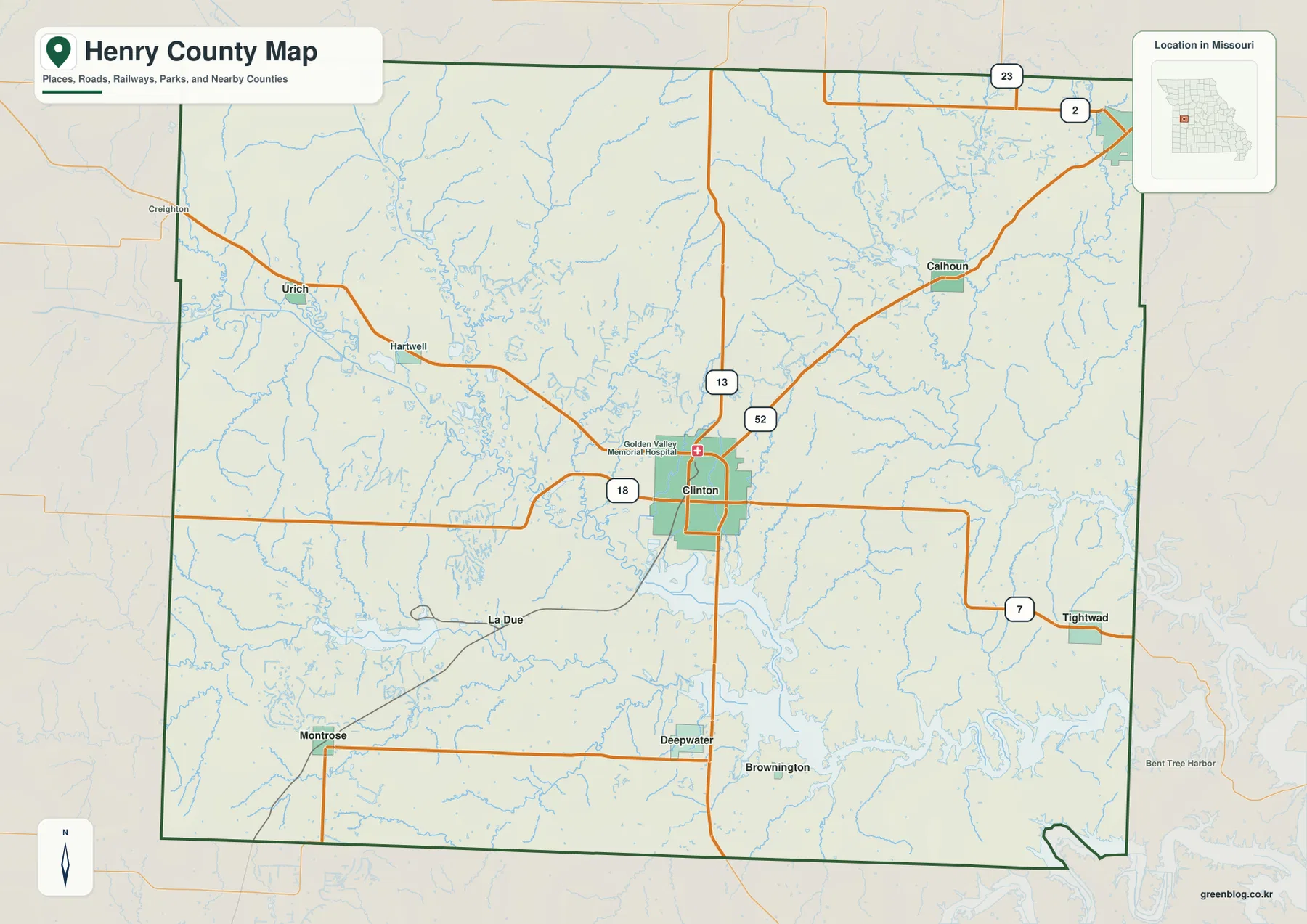
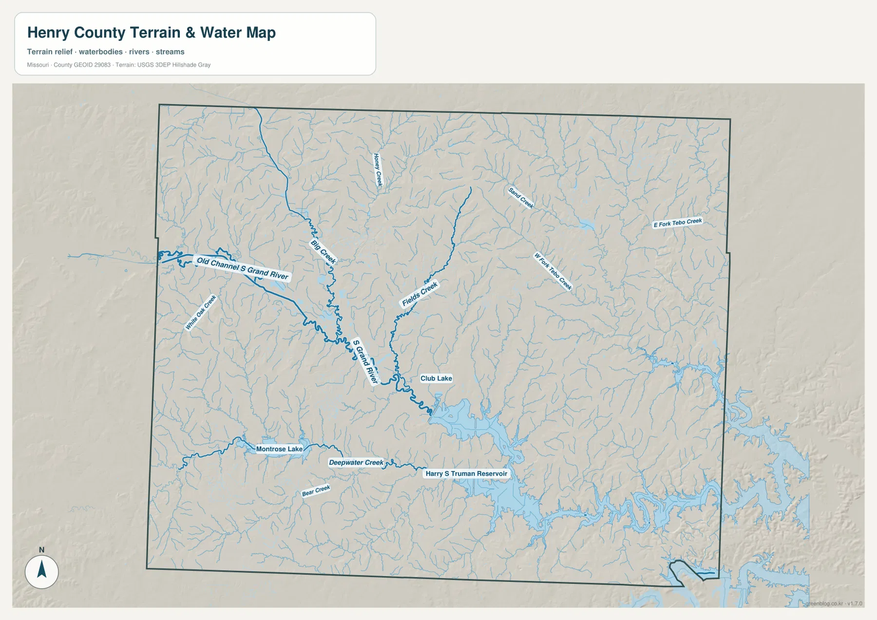
Henry County lies in west-central Missouri, with Clinton at the center of a broad rural landscape shaped by the South Grand River and the northern reaches of Harry S Truman Reservoir. The general map makes Clinton, Route 13, Route 18, Route 52, and the road toward Route 7 easy to locate. The ranked city layer adds Windsor, Urich, Montrose, Calhoun, and Deepwater, while the terrain-and-water map shows Big Creek, Fields Creek, the Tebo Creek forks, Deepwater Creek, smaller lakes, and the reservoir. The elevation map spans roughly 125 to 303 meters. High-resolution JPG versions of the same map themes are available in the download ZIP for printing, close inspection, or offline reference.
The easiest way to understand Henry County is to begin at Clinton and then compare the places around it. Windsor lies in the northeast, Urich in the northwest, Montrose in the southwest, and Deepwater to the south. The county’s road network is mostly rural rather than metropolitan, and the terrain changes noticeably toward the broad river and reservoir lowlands in the south and east.
Table of Contents
Clinton and Routes 13, 18, and 52 provide the main orientation
Clinton is the most prominent community on the general map and sits near the center of Henry County. Golden Valley Memorial Hospital is labeled in town, providing another easy visual reference. Route 13 runs north-south through the Clinton area, Route 18 extends west, and Route 52 angles northeast toward Calhoun. Route 7 appears farther east toward Tightwad. Together, these roads provide a practical framework for locating most of the county.
Urich and Hartwell lie northwest of Clinton, while La Due and Montrose are to the southwest. Deepwater and Brownington appear farther south, and Calhoun is positioned northeast of Clinton on the way toward Windsor. The general map is intended for county-scale orientation rather than current turn-by-turn navigation, so live road conditions and closures should be checked separately.
Windsor, Urich, and Montrose anchor different sides of the county
Windsor lies near the northeastern edge of Henry County, while Urich sits near the northwest. They are useful opposite-side references when comparing the county’s east-west extent. The Windsor side is associated with Sand Creek and the Tebo Creek drainage, while the Urich side is closer to Big Creek and the upper South Grand River system.
Montrose occupies the southwestern part of the county and provides a different reference closer to Montrose Lake and Deepwater Creek. Moving from the general map to the water layer makes the southern part of the county look much more complex because creeks, lakes, and the upper arms of Truman Reservoir begin to dominate the landscape.
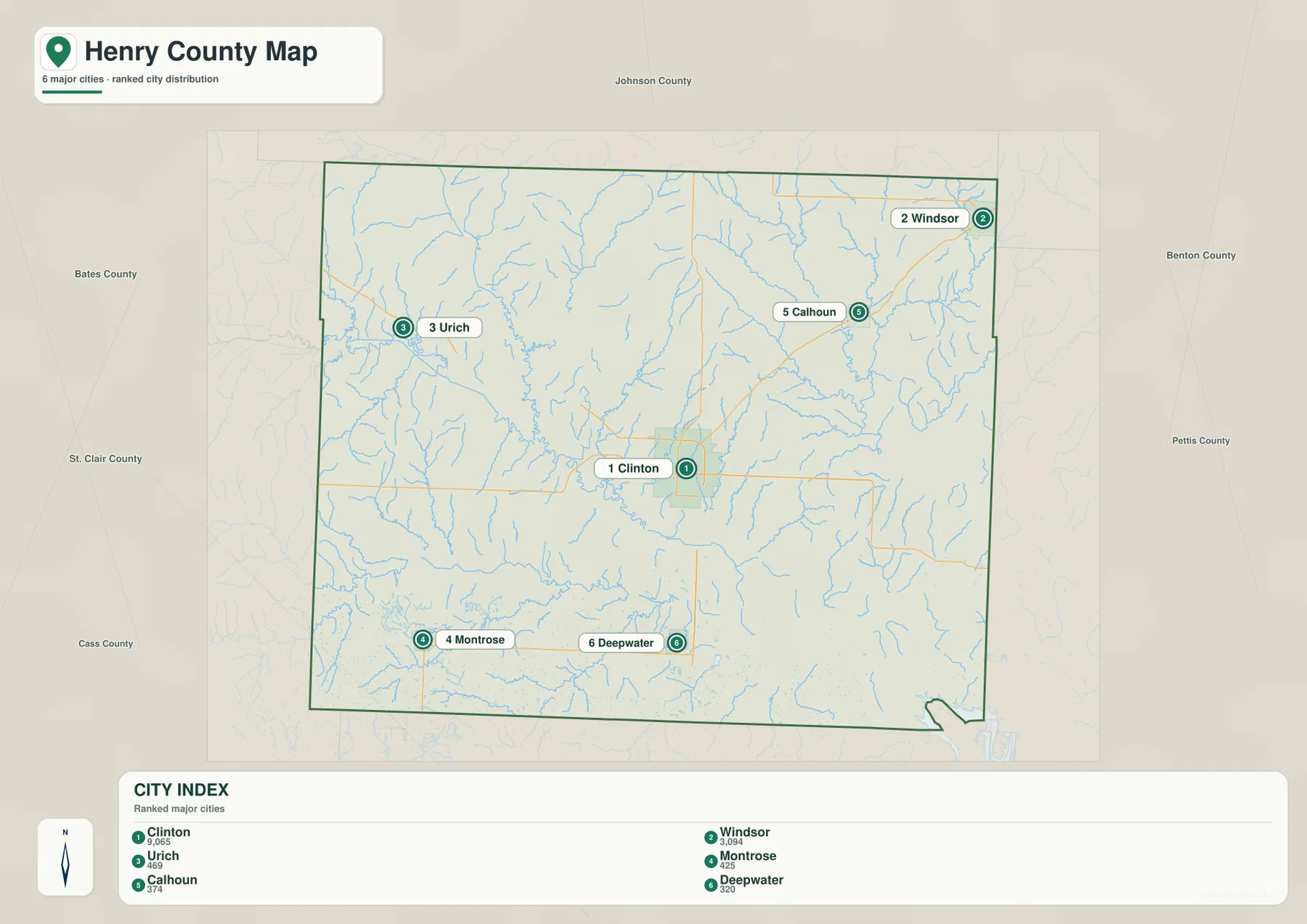
The ranked city map highlights six communities
The city distribution layer ranks Clinton first, Windsor second, Urich third, Montrose fourth, Calhoun fifth, and Deepwater sixth. The CITY INDEX also shows values of 9,065 for Clinton, 3,094 for Windsor, 469 for Urich, 425 for Montrose, 374 for Calhoun, and 320 for Deepwater. These figures should be treated as values from the map’s ranking dataset rather than as current official population estimates.
The geographic distribution is more important than the index values. Clinton occupies the center, Windsor the northeast, Urich the northwest, Montrose the southwest, Calhoun the northeast interior, and Deepwater the south. The numbered markers represent rank, not road mileage or travel time.
South Grand River forms the largest central-western valley
South Grand River is the most prominent river on the terrain-and-water map. It is labeled as S Grand River and winds from the west-central part of Henry County toward the Truman Reservoir system. Old Channel S Grand River is labeled separately, showing that older channel traces remain part of the mapped landscape near the present river. On the elevation layer, the river corridor appears as a broad green lowland.
Big Creek descends from the north and approaches the South Grand River system, while smaller waterways such as Miami Oak Creek add detail farther west. The branching drainage pattern explains why the rural area west and northwest of Clinton is divided into many smaller valleys even though the road map can look relatively open.
Fields Creek and the Tebo Creek forks organize the east
Fields Creek is a prominent central-eastern waterway, and North Fork Tebo Creek and East Fork Tebo Creek are labeled farther east. Sand Creek appears in the northeast. These channels feed the broad reservoir and river lowlands that dominate the eastern and southeastern parts of the county.
The Tebo Creek system is especially useful for orienting the area between Calhoun and Windsor. A reader can locate Route 52 and the northeastern road network on the general map, then switch to the water layer to see how the creeks occupy lower corridors between rolling ridges. The elevation layer reinforces the same pattern with green valleys and warmer uplands.
Deepwater Creek meets the Truman Reservoir landscape in the south
Deepwater Creek crosses the southern portion of the county from west toward the Harry S Truman Reservoir system. Montrose Lake lies to the southwest, while Bear Creek is labeled farther south. Moving east and southeast, the map becomes increasingly dominated by broad reservoir water and branching coves.
The U.S. Army Corps of Engineers manages Harry S. Truman Reservoir as a multipurpose project with flood-control, hydropower, fish-and-wildlife, and recreation functions. The Corps also identifies Henry County as one of the counties containing the project. The supplied county map shows only the portion relevant to Henry County, so the official Truman Lake material is the better source for reservoir-wide facilities and management information.
Club Lake and Montrose Lake provide smaller local landmarks
Club Lake is labeled in the south-central part of the water map, between the South Grand River corridor and the broader Truman Reservoir area. Montrose Lake lies farther southwest and helps distinguish the Montrose side of the county. Although these water bodies are much smaller than Truman Reservoir, they are useful fixed points when matching a location across the road, water, and elevation layers.
A named lake on a general county map does not by itself establish access rules, boating permissions, or current water conditions. Those questions should be checked with the relevant managing agency. The terrain-and-water layer is best used to understand location and drainage relationships rather than operational or legal conditions.
Elevation ranges from about 125 to 303 meters
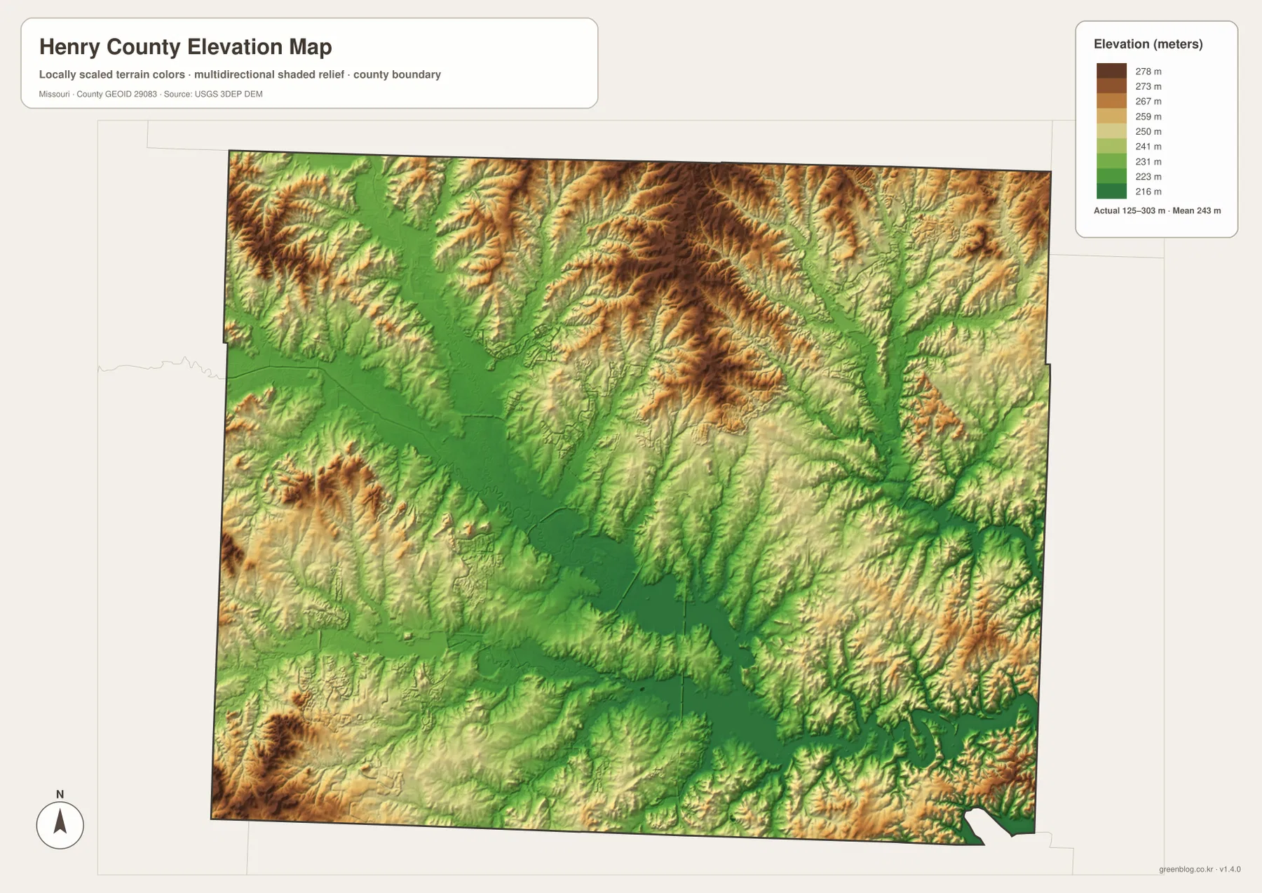
The elevation map reports an actual mapped range of roughly 125 to 303 meters, with a mean near 243 meters. The South Grand River and Truman Reservoir corridors form the broadest low green areas. Higher terrain becomes more extensive away from those waterways, particularly in the north-central and southwestern parts of the county.
The northern uplands are divided by many short tributary valleys rather than forming one isolated ridge. In the east, the Tebo Creek system cuts lower channels through rolling ground. In the south, the reservoir and Deepwater Creek create broad lowland corridors. This map is appropriate for county-scale terrain comparison but should not replace survey-grade or engineering-grade elevation data.
North and south of Clinton look very different
North of Clinton, the landscape contains more continuous upland ridges interrupted by narrow creek valleys. South of the city, the South Grand River and Truman Reservoir system creates a broader, lower landscape. Following Route 13 south from Clinton on the general map and then switching to the water layer makes that transition easy to see.
The elevation layer confirms the same change. The reservoir and major river valleys are green and low, while the northern interior contains more tan and brown terrain. The northeast toward Windsor and Calhoun has its own pattern of Tebo Creek valleys, and the northwest toward Urich is shaped more strongly by Big Creek and the South Grand River system.
Clinton is also the main administrative and service center
Henry County’s official website lists the county courthouse contact at 100 West Franklin in Clinton and provides access to county offices including the county commission, clerk, assessor, recorder of deeds, and other departments. That current public information matches the map’s role for Clinton as the county’s primary administrative reference.
University of Missouri Extension maintains its Henry County office at 120 E. Lincoln St. in Clinton and provides local programs in agriculture, 4-H, business, health, and community education. Readers can use the map to understand Clinton’s location, then rely on the official pages for current office hours, contacts, and services.
Choosing the right downloadable map
Use the general county map when towns and highways are the priority. The ranked city map is the quickest way to compare Clinton, Windsor, Urich, Montrose, Calhoun, and Deepwater. The terrain-and-water map is best for the South Grand River, Big Creek, Tebo Creek forks, Deepwater Creek, local lakes, and Truman Reservoir. The elevation layer gives the clearest view of low river and reservoir corridors versus the surrounding uplands.
The download ZIP contains high-resolution JPG files for the same map themes shown on the page. They are useful for enlarging labels, printing reference sheets, and comparing layers side by side. The files are intended for general geographic reference and do not replace live navigation, flood warnings, legal boundary surveys, or professional elevation measurements.
Frequently Asked Questions
What is the easiest place to use as a reference in Henry County?
Clinton is the clearest starting point. Routes 13, 18, and 52 connect nearby, county offices are located there, and the city provides a convenient reference for Windsor, Urich, Montrose, and Deepwater.
Do the numbers on the city map show road distance?
No. They rank Clinton, Windsor, Urich, Montrose, Calhoun, and Deepwater within the supplied city dataset. The markers and CITY INDEX values are not mileage or travel-time measurements.
What elevation range does the Henry County map show?
The elevation layer shows an actual range of about 125 to 303 meters, with a mean near 243 meters. The South Grand River and Truman Reservoir corridors are among the lowest areas, while higher uplands occupy much of the north-central and southwestern county.
Map File Information
Download the map files associated with this page for reference, printing, and compatible visual projects.
- Included Files: Use only the versions confirmed in the article and supplied images
- File Type: Use the confirmed download contents
- Intended Use: Printing, education, presentations, and map-based projects
Related Maps
Sources and references
- Henry County Missouri Official Website – courthouse and county government information in Clinton
- University of Missouri Extension – Henry County – Clinton county office and local public programs
- U.S. Army Corps of Engineers – Harry S. Truman Lake – official reservoir management and project information
- U.S. Census Bureau TIGER/Line Shapefiles – county boundary and road data
- USGS National Hydrography – rivers, streams, and water features
- USGS 3D Elevation Program – elevation data
Green Map creates custom-edited map images using open geographic data sources such as geoBoundaries, Natural Earth, OpenStreetMap, and government open data. These maps are edited visual materials, not raw data files, and are provided for education, documents, presentations, and graphic reference.