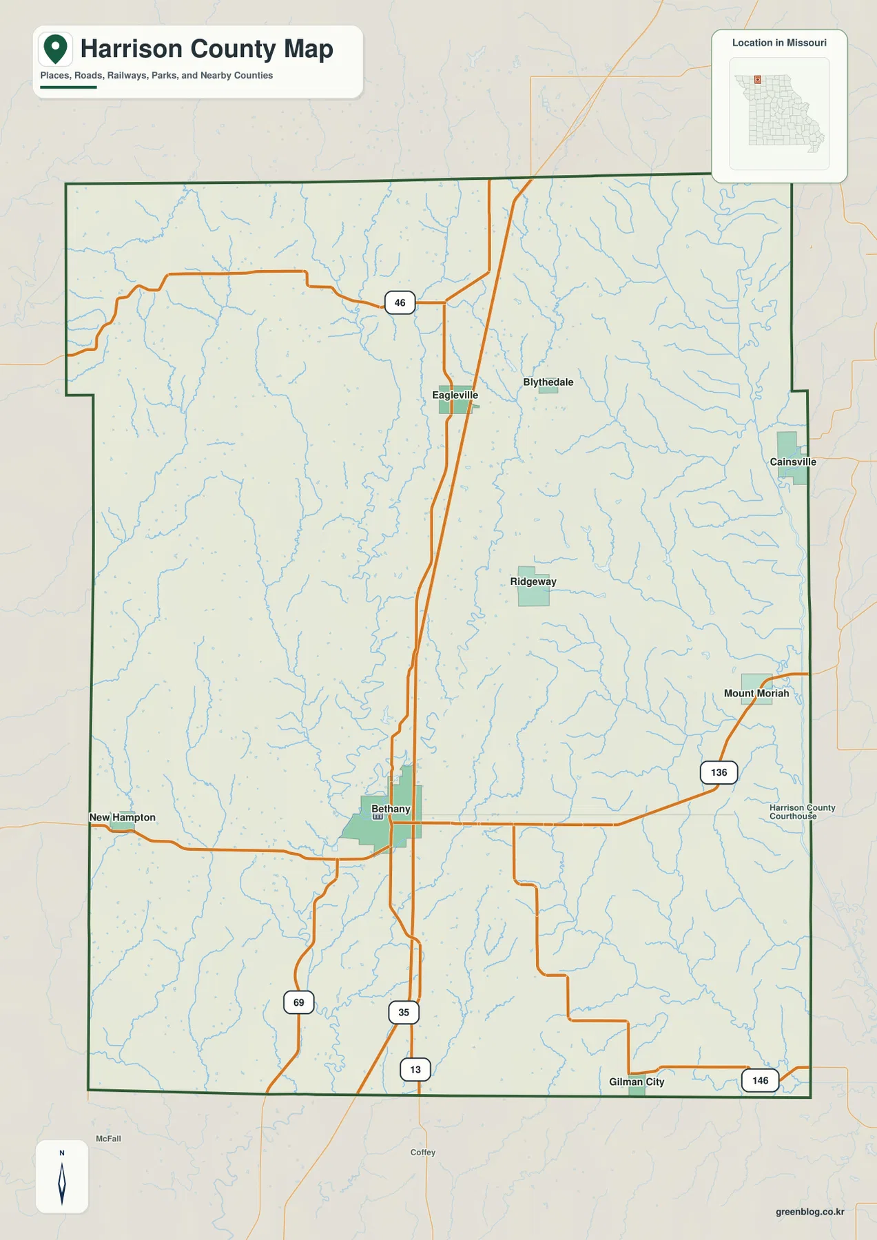
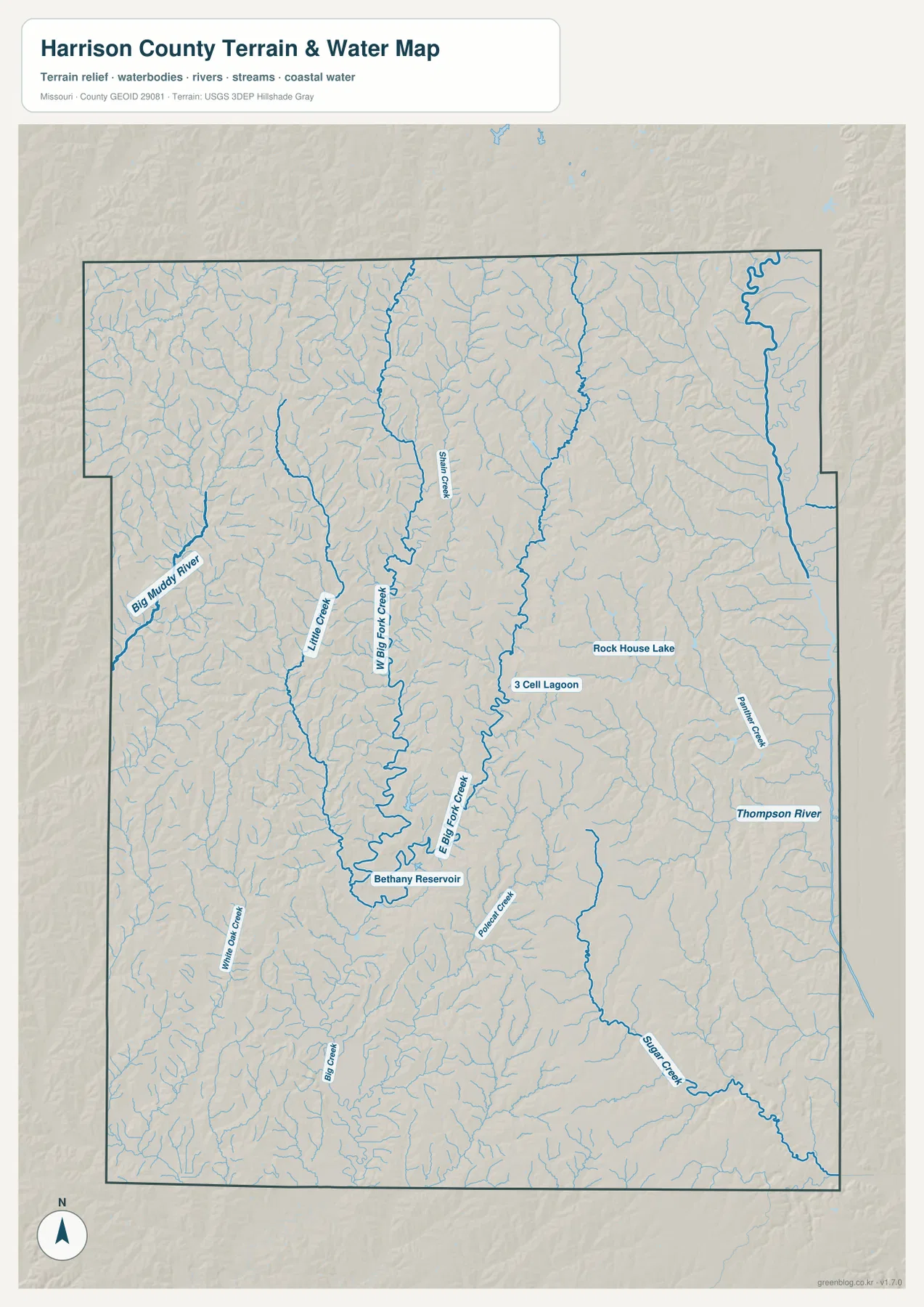
Harrison County occupies northern Missouri, where Bethany serves as the clearest town reference and a branching network of rivers and creeks divides rolling farmland into long valleys and ridges. The general map highlights U.S. 136, I-35, U.S. 69, Route 13, and smaller communities such as Ridgeway, Eagleville, Blythedale, Cainsville, and New Hampton. The terrain-and-water layer adds Big Muddy River, West Fork and East Fork Big Creek, Thompson River, Sugar Creek, and several named reservoirs and lakes. The elevation map shows a mapped range of roughly 231 to 364 meters. High-resolution JPG versions of the same map themes are available together in the download ZIP for printing or offline reference.
The county makes more sense when Bethany is used as a starting point. Ridgeway lies to the north and east, Eagleville and Blythedale occupy the northern section, New Hampton sits near the western side, and Cainsville is close to the eastern boundary. The towns are separated by broad rural areas, but those spaces are far from featureless: streams, low valleys, and higher ridges fill the land between them.
Table of Contents
Bethany and U.S. 136 provide the main road reference
Bethany is the most prominent place on the general county map, and the Harrison County Courthouse is labeled in town. U.S. 136 crosses the county through Bethany, connecting the New Hampton side in the west with Mount Moriah and the eastern side. I-35 runs north-south just east of Bethany, while U.S. 69 and Route 13 provide additional references toward the southern county line.
From Bethany, roads continue north toward Ridgeway, Eagleville, and Blythedale. The rural network is not a dense urban grid; many roads bend or change direction as they cross creek valleys and farmland. The map is best used for county-scale orientation rather than live navigation, so current road conditions and final driving directions should be checked separately.
Eagleville, Blythedale, and Cainsville spread across the north
Eagleville and Blythedale occupy the north-central portion of Harrison County, while Cainsville is much farther east near the county boundary. Route 46 provides a useful east-west reference around Eagleville, and the road south from that area connects toward Bethany. The spacing between these towns shows how broad the northern rural area is.
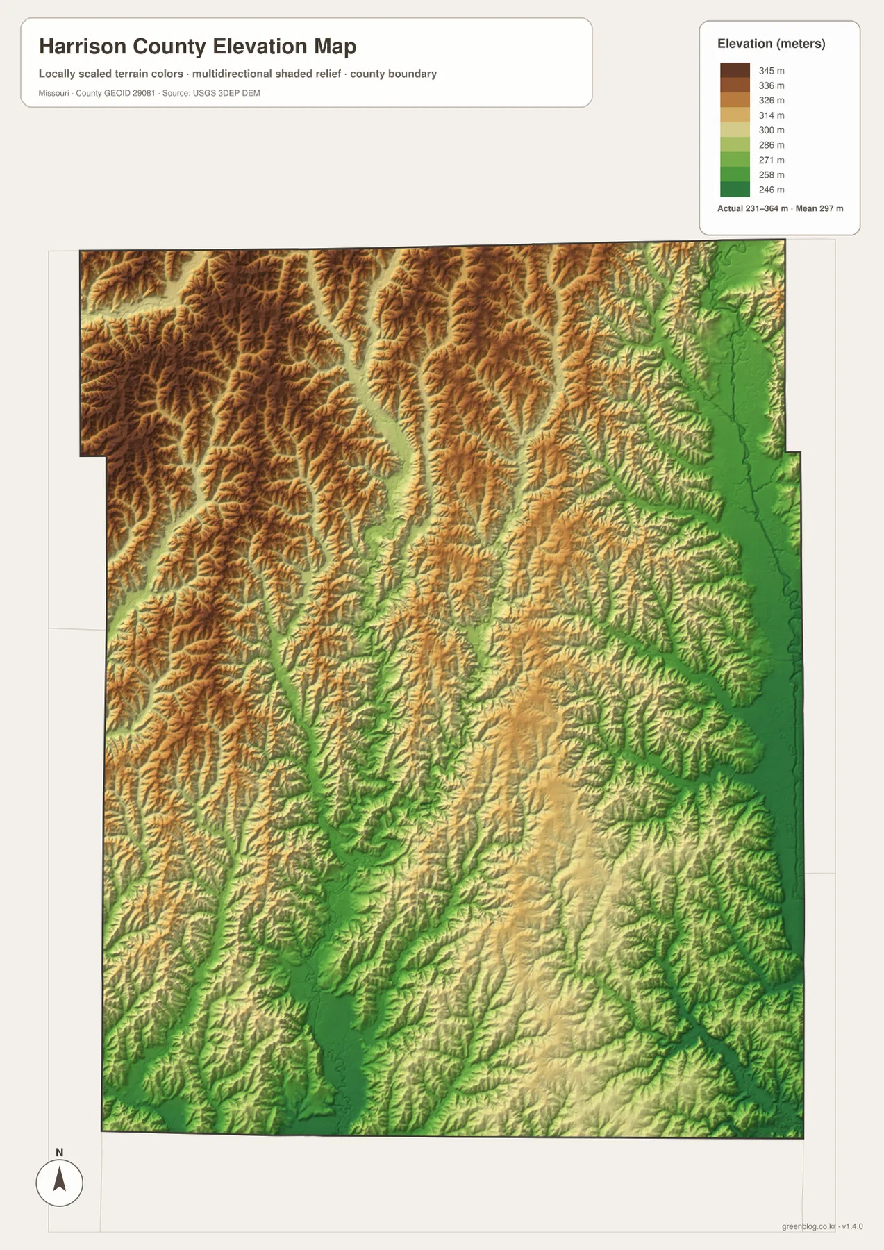
The eastern side around Cainsville also sits in a very different terrain setting from the northwest. The Thompson River corridor and its tributaries occupy lower ground near the eastern edge, while the northwest contains much stronger upland relief. That contrast is particularly obvious on the elevation map, where the far east is green and the northwest is dominated by tan and brown ridges.
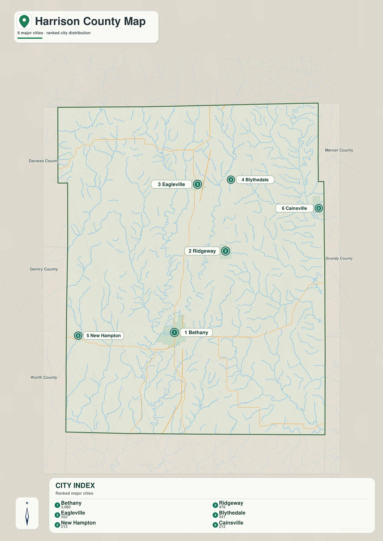
The city layer ranks six widely separated communities
The city distribution map ranks Bethany first, Ridgeway second, Eagleville third, Blythedale fourth, New Hampton fifth, and Cainsville sixth. The CITY INDEX displays values of 3,080 for Bethany, 478 for Ridgeway, 352 for Eagleville, 341 for Blythedale, 213 for New Hampton, and 212 for Cainsville. These are values from the map’s ranking dataset and should not be treated as current official population estimates.
The geographic pattern is more important than the numbers. Bethany lies in the south-central part of the county, Ridgeway is north and east of it, Eagleville and Blythedale are farther north, New Hampton is west, and Cainsville is close to the eastern edge. The numbered markers represent rank rather than road mileage or travel time.
Big Muddy River defines the western lowland
Big Muddy River is the most prominent watercourse along the western side of the terrain-and-water map. It follows a broad lower corridor and receives many small tributaries from the surrounding rolling farmland. On the elevation map, the river valley appears as a green band cut into higher ground.
Little Creek and West Fork Big Creek lie east of the Big Muddy corridor and form separate north-south valleys. The western half of Harrison County therefore contains several parallel drainage lines rather than one single river valley. This is why the apparently open rural area on the road map becomes much more detailed when the water layer is viewed.
West Fork and East Fork Big Creek split the central uplands
West Fork Big Creek and East Fork Big Creek run through the central portion of Harrison County in separate valleys. Smith Creek joins the western drainage, while Powell Creek and smaller tributaries add detail around East Fork Big Creek. On the elevation map, both valleys form long green corridors with higher ridges between them.
Bethany Reservoir is labeled near the West Fork Big Creek side of the county. It provides a useful local landmark when comparing the water layer with Bethany and the central road network. The map is intended for general geographic reference, not for current water levels, flood warnings, legal shoreline boundaries, or boating rules.
Thompson River and Sugar Creek create the eastern low country
Thompson River runs along the eastern side of Harrison County and provides the strongest natural reference for that part of the map. Prairie Creek crosses the east-central interior, while Sugar Creek bends through the southeast. Together, these waterways create a broad set of lower valleys around the Cainsville and Mount Moriah side of the county.
The elevation layer makes the eastern pattern especially clear. The Thompson River side contains the widest expanse of dark green low terrain, while the northwest rises into much higher brown and tan ridges. Shorter ridges remain between East Fork Big Creek and the Thompson corridor, but the overall eastward drop is easy to see at county scale.
Rock House Lake and other small water features help with local orientation
Rock House Lake is labeled in the east-central part of the water map, and 3 Cell Lagoon appears southwest of it. These are much smaller features than the major rivers, but they can be useful when matching a local area between map layers. Rock House Lake sits between the East Fork Big Creek and Prairie Creek sides of the county, giving readers another fixed point in an area with many similar-looking tributary valleys.
Official Missouri Department of Conservation pages also describe Harrison County Lake and North Bethany City Reservoir as public water resources in the county. Those are separate named sites and should not be confused with the Bethany Reservoir label on the supplied map. Readers planning a visit or fishing trip should use the relevant official page for current access and regulations.
Elevation ranges from about 231 to 364 meters
The elevation map reports an actual mapped range of approximately 231 to 364 meters, with a mean near 297 meters. The northwest contains the strongest brown and tan relief, showing a dense set of higher ridges. West Fork and East Fork Big Creek cut lower north-south corridors through the middle, while the Thompson River valley forms a much broader green lowland along the eastern edge.
The southern part of the county is not completely flat either. Tributaries carve narrow lower corridors around and south of Bethany, and Sugar Creek creates another low route toward the southeast. This map is appropriate for broad county-scale terrain comparison, but it is not survey-grade or engineering-grade elevation data for construction or parcel decisions.
Comparing east and northwest reveals the county’s strongest terrain contrast
Bethany makes a useful midpoint for comparing the two sides of Harrison County. Following U.S. 136 east toward Mount Moriah brings the map closer to the Thompson River lowland, where lower green terrain becomes broader. Moving northwest from Bethany toward the Eagleville side leads into stronger ridge relief and many short tributary valleys.
The difference also helps explain the road pattern. Eastern roads cross or follow wider river valleys, while the northwest is divided by more tightly spaced ridges and creeks. A practical map-reading method is to locate a town on the general map, identify the nearest named stream on the water layer, and then check the same place on the elevation map.
Bethany is also the main reference for county services
University of Missouri Extension maintains its Harrison County office in the courthouse basement in Bethany and provides local resources for agriculture, 4-H, and community education. That public office information connects the map’s main town with current county services.
Bethany also serves as the practical administrative reference for Harrison County. The map is useful for location context, while current contacts, hours, and procedures should be checked through the relevant official agency pages.
Choosing the most useful downloadable map
Use the general county map when roads, towns, and the county boundary are the priority. The ranked city layer provides the quickest comparison of Bethany, Ridgeway, Eagleville, Blythedale, New Hampton, and Cainsville. The terrain-and-water map is best for Big Muddy River, the Big Creek forks, Thompson River, Sugar Creek, reservoirs, and lakes. The elevation map gives the clearest view of the high northwest and low eastern river corridor.
The ZIP contains high-resolution JPG versions of the same map themes shown on the page. They are useful for enlarging labels, printing a reference sheet, or comparing layers side by side. The files are intended for general geographic reference and do not replace live navigation, flood warnings, legal boundary surveys, or professional elevation measurements.
Frequently Asked Questions
What is the easiest place to use as a reference in Harrison County?
Bethany is the clearest starting point. U.S. 136 and I-35 are nearby, the courthouse is marked there, and the city provides a convenient reference for Ridgeway, New Hampton, Mount Moriah, and the major river valleys.
Do the numbers on the city map show distance or travel time?
No. They rank Bethany, Ridgeway, Eagleville, Blythedale, New Hampton, and Cainsville within the supplied city dataset. The markers and CITY INDEX values are not mileage or travel-time measurements.
Why is the Thompson River side much lower on the elevation map?
The Thompson River and its tributaries occupy a broad river valley along the eastern side of the county. On the supplied elevation map, that low corridor appears in green and contrasts sharply with the higher ridges of the northwest.
Map File Information
Download the map files associated with this page for reference, printing, and compatible visual projects.
- Included Files: Use only the versions confirmed in the article and supplied images
- File Type: Use the confirmed download contents
- Intended Use: Printing, education, presentations, and map-based projects
Related Maps
Sources and references
- University of Missouri Extension – Harrison County – county office and public programs in Bethany
- Missouri Department of Conservation – Harrison County Lake – official county lake and recreation information
- U.S. Census Bureau TIGER/Line Shapefiles – county boundary and road data
- USGS National Hydrography – rivers, streams, and water features
- USGS 3D Elevation Program – elevation data
Green Map creates custom-edited map images using open geographic data sources such as geoBoundaries, Natural Earth, OpenStreetMap, and government open data. These maps are edited visual materials, not raw data files, and are provided for education, documents, presentations, and graphic reference.