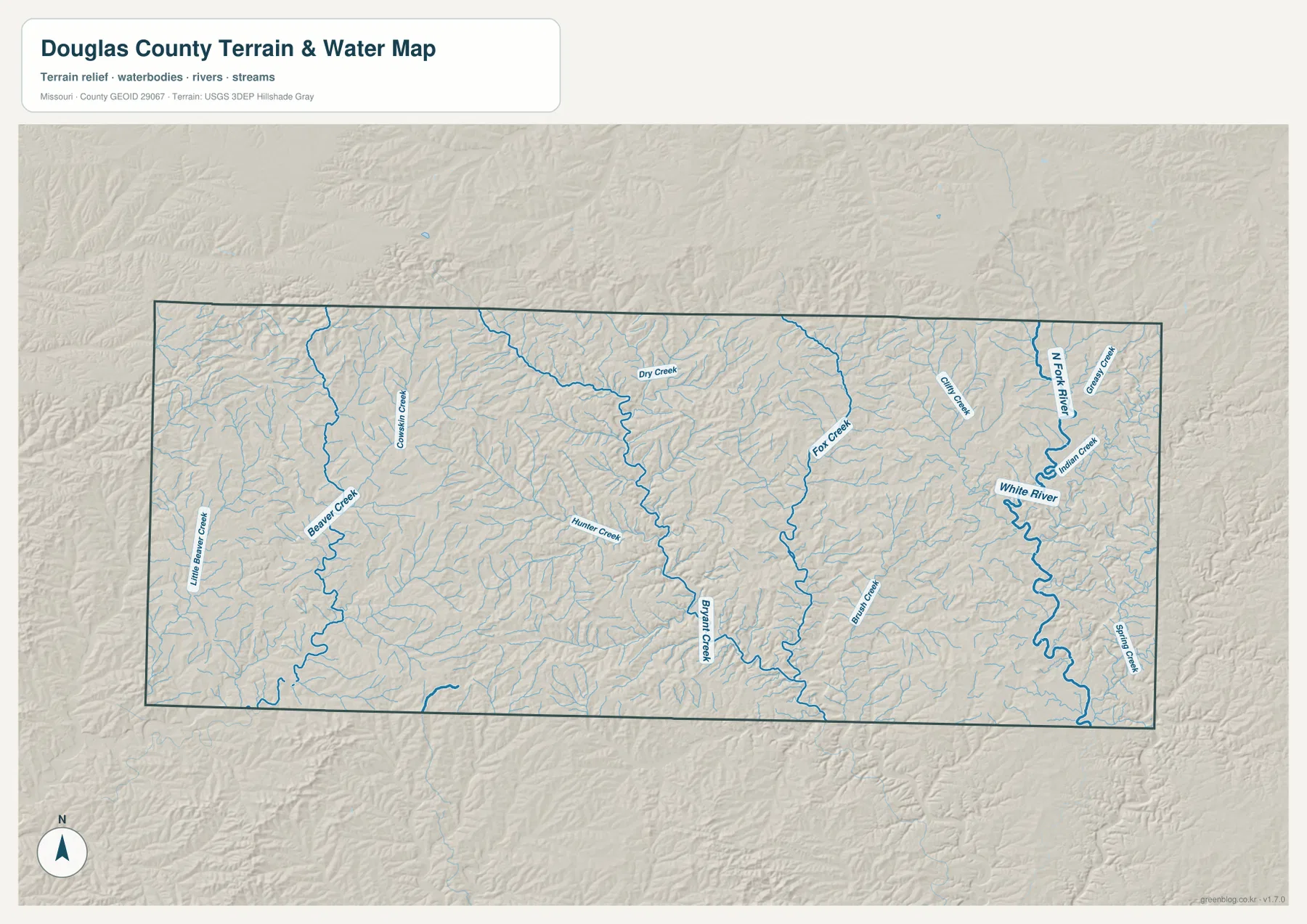
Douglas County stretches across the southern Missouri Ozarks, with Ava serving as the clearest town reference and a dense network of streams cutting through the surrounding hills. The general map makes Routes 14, 5, 76, and 95 easy to locate, while the terrain-and-water layer brings Bryant Creek, White River, North Fork River, Dry Creek, and many smaller tributaries into view. The elevation map adds a mapped range of roughly 214 to 520 meters. High-resolution JPG versions of the map layers are also available together in a ZIP for printing, close inspection, or offline reference. High-resolution map files are available for download in the section below.
The county is long from west to east, and Ava sits in the western half rather than at the geographic center. Outside Ava, the landscape is predominantly rural, with roads curving around ridges and following valleys instead of forming a dense urban grid. Nearby places such as Mansfield, Norwood, and Mountain Grove appear outside the county boundary on the general map, but Ava is the strongest internal reference. Starting there and following Route 76 east, Route 5 south, or the roads toward U.S. 181 is an efficient way to understand the county’s overall layout.
Table of Contents
Ava is the easiest starting point for the road map
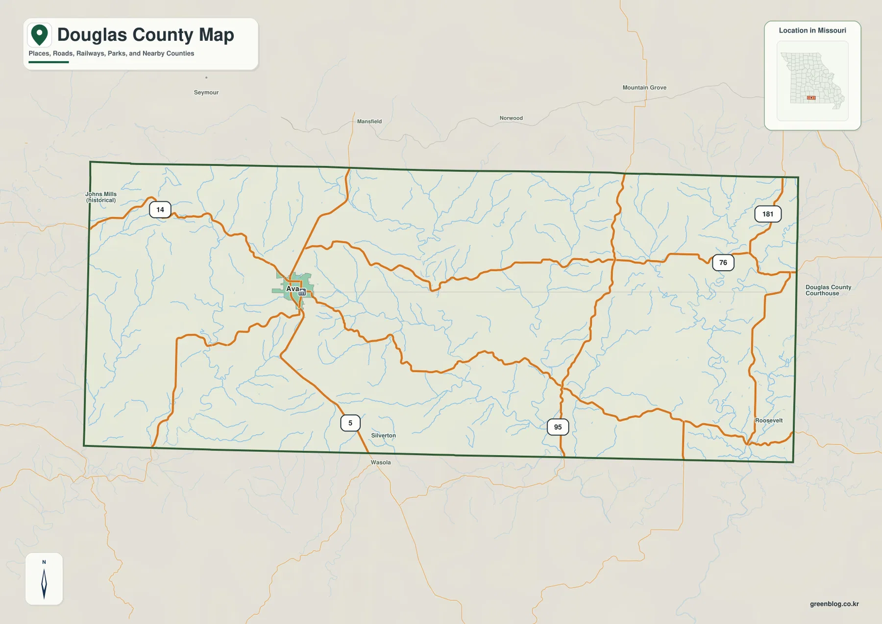
Ava stands out immediately on the general county map. Route 14 enters from the west and reaches the Ava area, Route 5 continues south toward the county boundary, and Route 76 runs east across a large part of Douglas County. Farther east, U.S. 181 appears near the northeastern side, while Route 95 provides another reference in the southeastern half. Together these roads create a practical framework for locating the county’s many rural valleys and smaller road connections.
The road pattern becomes increasingly curved away from Ava. That shape is not random: the blue stream lines and the shaded terrain reveal a county divided by many ridges and drainage valleys. Some routes follow broader low ground, while others cross between adjacent ridges. The general map is useful for broad orientation, but it should not be treated as a live navigation product. Current closures, turn-by-turn routing, and road conditions should always be checked with an up-to-date navigation or transportation source.
The ranked city layer highlights Ava alone
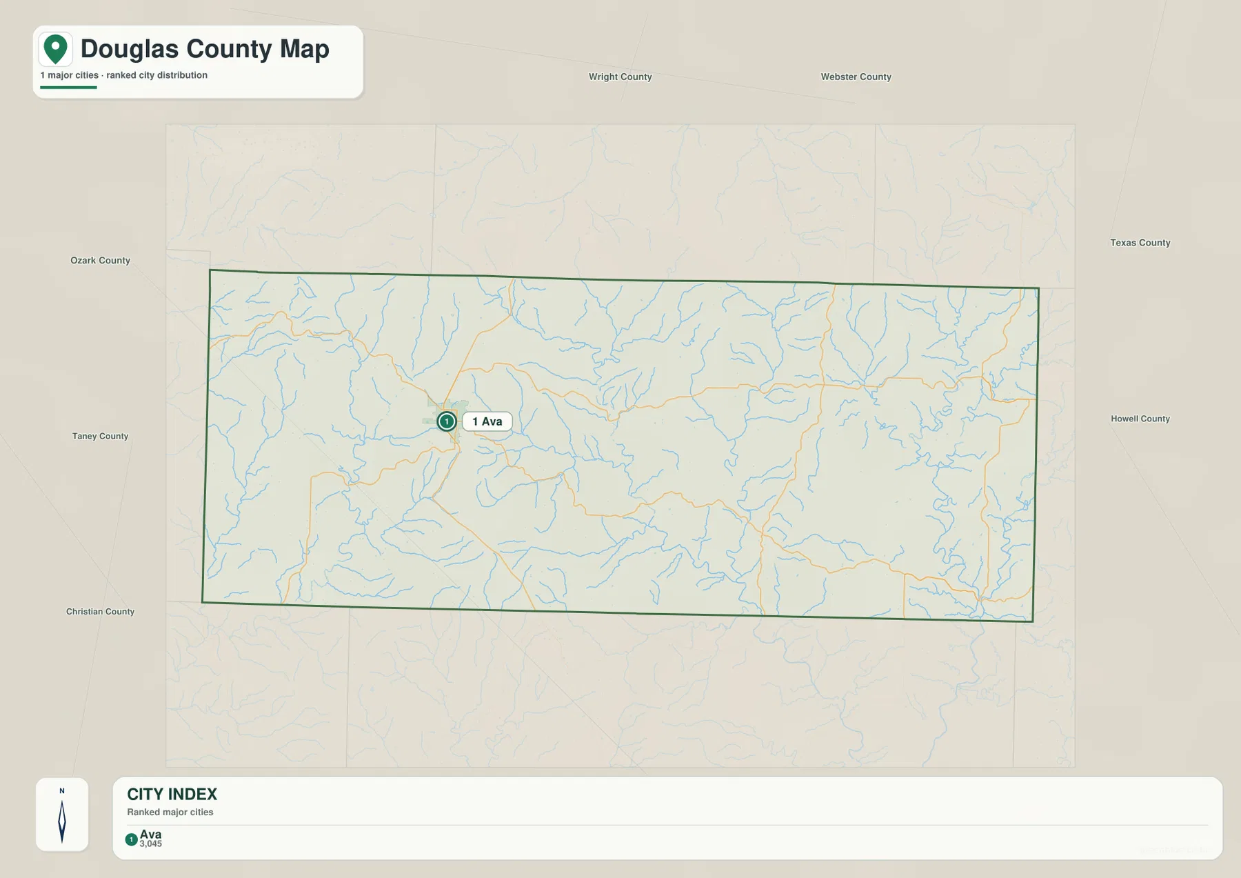
The city distribution map differs from many county maps because its CITY INDEX contains only one ranked major city. Ava is marked as number 1 with a value of 3,045. That number should be understood as the value used by the map’s city-ranking dataset, not as a claim about the latest official population estimate. Readers who need current demographic counts should check a current U.S. Census Bureau source rather than treating the map label as a live statistic.
A single-city layer still tells readers something useful: Ava is the strongest urban reference in the supplied county map set. The Missouri Association of Counties lists numerous Douglas County offices at Ava addresses, and University of Missouri Extension maintains its Douglas County office in Ava as well. Those public sources reinforce the practical role of Ava when looking up county services, while the map shows where that local center sits relative to the surrounding roads and Ozark terrain.
Bryant Creek cuts a long valley through the interior
Bryant Creek is one of the most prominent watercourses on the terrain-and-water map. It runs through the central part of Douglas County and continues southward, with Hunter Creek and numerous smaller tributaries joining the larger valley system. On the elevation map, the Bryant Creek corridor appears lower than the ridges on either side. That comparison makes it easy to see how the creek occupies a valley floor within the broader Ozark uplands.
The Bryant Creek area is a good example of why the water and elevation layers work well together. The water map identifies the channel and nearby tributaries, while the shaded relief shows a repeating sequence of narrow ridges and lower drainage corridors. Roads in this part of the county often bend through or around that terrain. Instead of viewing the road network as a set of isolated lines, readers can use Bryant Creek as a geographic anchor for the central and southern interior.
White River and North Fork River shape the eastern lowlands
The eastern half of Douglas County contains some of the most conspicuous low valleys on the map. White River is labeled along a winding corridor, and a large N Fork River label appears farther northeast. Indian Creek, Spring Creek, Greasy Creek, and Emry Creek add detail to the same part of the county. Compared with the high western ridges, these eastern valleys occupy broader bands of green on the elevation layer.
The rivers and valleys continue beyond the county line, which is important when interpreting the map. Administrative boundaries stop at the dark county outline, but waterways and terrain do not. That is why some stream systems look incomplete if only the interior of Douglas County is considered. The water map is intended for geographic reference; it is not a flood forecast, legal parcel map, or navigation chart. Current water levels and warnings should be checked with official monitoring agencies.
Dry Creek, Fox Creek, and Beaver Creek divide the uplands
North-central Douglas County contains Dry Creek, while Fox Creek is prominent farther east. On the western side, Beaver Creek, Little Beaver Creek, and Cowskin Creek occupy a separate group of valleys. These streams are smaller than the White River system, but they are important for understanding the texture of the county. Their branching tributaries carve the uplands into many narrow ridges rather than leaving a broad, continuous plateau.
The terrain-and-water map also labels Hunter Creek, Brush Creek, Indian Creek, Spring Creek, and Greasy Creek. Between the named channels are many smaller streams without large labels. Together they create a tree-like drainage network across nearly the entire county. This pattern is especially clear when the water map is compared with the elevation layer: low green corridors follow the streams, and warmer colors occupy the ridges between them.
Elevation spans roughly 214 to 520 meters
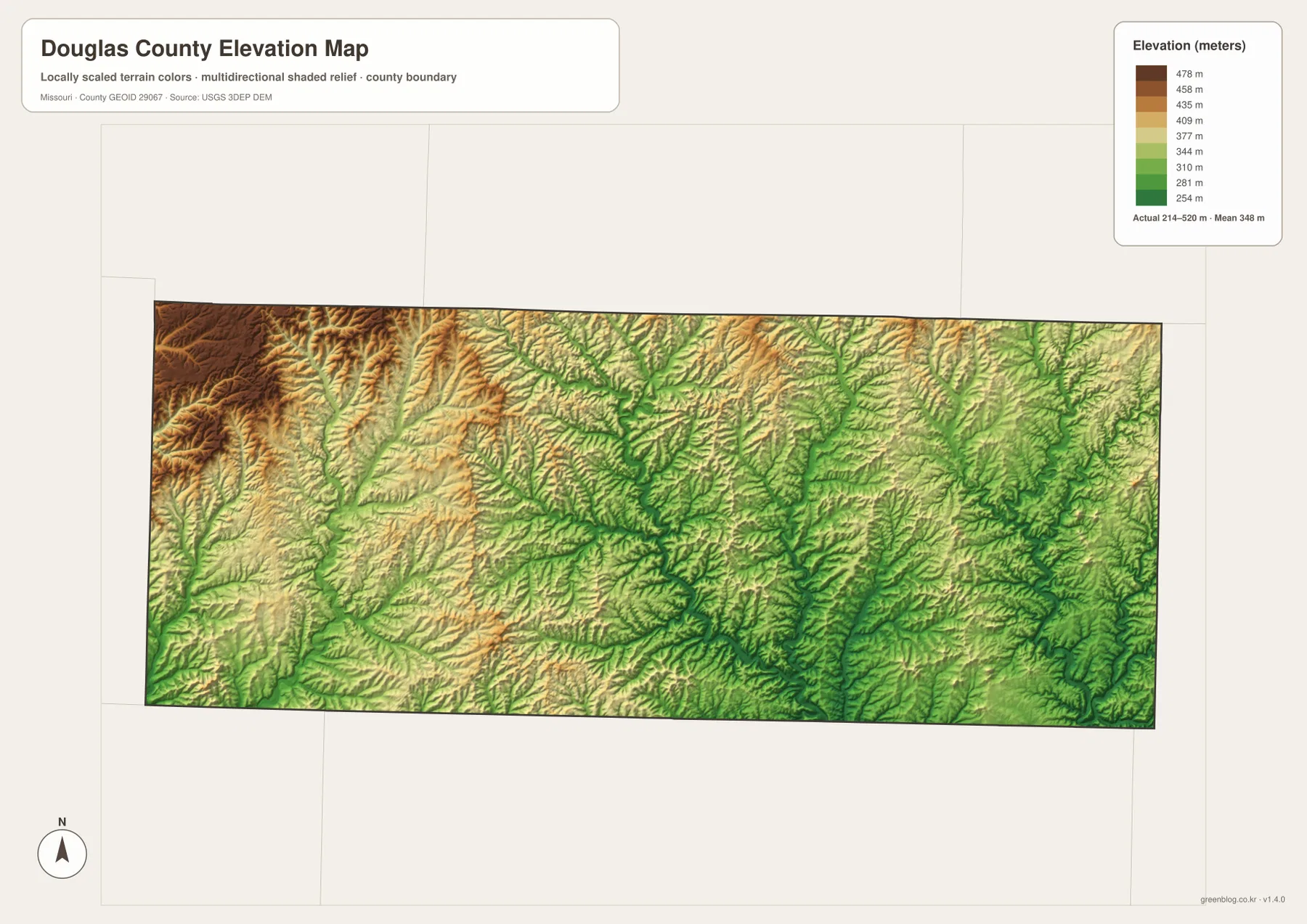
The elevation map reports an actual mapped range of about 214 to 520 meters, with a mean near 348 meters. The highest terrain is concentrated strongly in the west and northwest, where dark tan and brown shades cover long ridges. Lower ground appears in green along Bryant Creek, White River, North Fork River, and many tributary valleys. The county therefore has substantial local relief even though it is not organized around one isolated mountain peak.
A close look at the shaded relief shows dozens of narrow ridges separated by creek valleys. The west and northwest contain wider areas of high ground, while the central and eastern portions include larger low corridors connected to major streams. This is a generalized county-scale elevation surface suited to geographic comparison. It should not be used as a substitute for survey-grade elevations, engineering design data, or parcel-specific measurements.
West of Ava, the higher ridges become more obvious
The area west and northwest of Ava contains some of the county’s highest terrain. Route 14 crosses this side of the county, while Beaver Creek and Cowskin Creek occupy narrow valleys between the ridges. On the elevation layer, broad brown and tan bands dominate the northwest. The water layer then reveals the smaller channels that cut through those uplands, making it easier to understand why roads curve rather than following a simple straight course.
This western contrast is useful because Ava itself sits near a transition between higher ridges and the more dissected central interior. Following the map west from Ava leads into higher ground, while following Route 76 east eventually brings the reader toward broader river valleys. The difference is visible even without technical terrain analysis: western colors are generally warmer and higher, while many eastern stream corridors are greener and lower.
Eastward along Route 76, river valleys take over
Route 76 is a strong east-west guide across the county. Starting near Ava and moving east, the road enters a landscape increasingly shaped by tributaries leading toward the White River and North Fork River systems. U.S. 181 near the northeastern side provides another orientation point. The general road map shows the route locations; the water layer explains the surrounding valleys, and the elevation map shows where those valleys sit below the neighboring ridges.
The eastern half is not uniformly low, because narrow ridges remain between streams, but the large river corridors occupy more visible low ground than in the high northwest. Greasy Creek, Indian Creek, Spring Creek, and Emry Creek help break this part of the county into smaller sections. Readers who are trying to match a road location to the landscape can often use one of these named streams as a better local landmark than a county-wide compass direction.
Route 5 and Route 95 lead into a more rugged southern landscape
Route 5 runs south from the Ava area and is the simplest reference for the southwestern and south-central portions of Douglas County. Urban labels become sparse as the route leaves Ava, while small tributaries and ridge lines become more prominent. The elevation colors also change repeatedly over short distances, reflecting the close spacing of valleys and uplands. That combination gives the southern interior a distinctly rural and rugged appearance on the maps.
Route 95 serves a similar purpose farther east. It crosses an area where many small streams feed toward larger eastern river systems. Roads in this terrain often weave between drainage valleys and ridge tops, so the county map and terrain map complement one another particularly well here. Anyone traveling to a specific rural destination should use the map for broad orientation and confirm the final route with current road information before departure.
A simple way to compare the four map layers
Begin with one familiar point such as Ava. Locate the town and the major roads on the general map, then switch to the city layer to see how strongly Ava stands out in the simplified settlement view. Move next to the terrain-and-water layer and follow Bryant Creek or the streams east of town. Finally, check the elevation map to see which of those channels occupy lower ground and where the surrounding ridges rise.
The same method works in the eastern river country. Find White River on the water map, then compare the same area with Route 76 and U.S. 181 on the general map. The elevation layer reveals the lower green valley surrounded by higher terrain. In the west, Beaver Creek and Route 14 make another useful pair. Moving one location at a time between the maps is more effective than trying to memorize every road, stream, and elevation color at once.
Using the downloadable JPG files
The download ZIP contains high-resolution JPG versions of the general county map, ranked city map, terrain-and-water map, and elevation map. The WebP images embedded in the page are efficient for quick viewing, while the JPG files are better for enlarging road labels, printing a reference sheet, or comparing multiple layers side by side. Keeping the files in one folder also makes it easy to move between transportation, water, and relief information without reopening the page.
Use the general map when roads and broad place orientation matter most. The city map provides the simplest view of Ava’s location. The terrain-and-water map is best for Bryant Creek, White River, North Fork River, Dry Creek, Fox Creek, and other named channels. The elevation map is the clearest choice for comparing the high northwest with the lower eastern valleys. These files are intended for general geographic reference and do not replace legal surveys, emergency information, or engineering-grade data.
Public sources for Ava and Douglas County
The Missouri Association of Counties publishes a Douglas County page with county office contacts and several Ava addresses, including offices at 203 SE 2nd Ave. University of Missouri Extension also maintains a Douglas County office in Ava and provides local educational and community resources. These pages are useful companions to the maps because they connect the county’s main urban reference with real public services.
For geographic data, U.S. Census Bureau TIGER/Line resources provide county boundaries and road information, USGS National Hydrography covers rivers and streams, and the USGS 3D Elevation Program provides elevation data. Checking these official sources is appropriate when a reader needs more detail than a general county map can show, particularly in a county with such a dense network of valleys and ridges.
Frequently Asked Questions
What is the easiest place to use as a reference in Douglas County?
Ava is the clearest starting point. It is the only ranked major city on the city layer and sits near Routes 14, 5, and 76, making it easy to orient the rest of the county.
Why does the city map show only Ava?
The supplied ranked-city layer contains only one major city entry for Douglas County. That does not mean there are no other named communities or rural settlements; it reflects the ranking dataset used for this particular map.
What elevation range is shown on the Douglas County map?
The elevation layer shows an actual range of about 214 to 520 meters, with a mean near 348 meters. Higher ridges are concentrated in the west and northwest, while Bryant Creek, White River, and other stream valleys occupy lower ground.
Map File Information
Download the map files associated with this page for reference, printing, and compatible visual projects.
- Included Files: Use only the versions confirmed in the article and supplied images
- File Type: Use the confirmed download contents
- Intended Use: Printing, education, presentations, and map-based projects
Related Maps
Sources and references
- Missouri Association of Counties – Douglas County – county office contacts and Ava addresses
- University of Missouri Extension – Douglas County – the Ava county office and local public programs
- U.S. Census Bureau TIGER/Line Shapefiles – county boundary and road data
- USGS National Hydrography – rivers, streams, and water features
- USGS 3D Elevation Program – elevation data
Green Map creates custom-edited map images using open geographic data sources such as geoBoundaries, Natural Earth, OpenStreetMap, and government open data. These maps are edited visual materials, not raw data files, and are provided for education, documents, presentations, and graphic reference.