Worcester County occupies a broad interior section of central Massachusetts, stretching well beyond the city of Worcester to northern centers such as Leominster, Fitchburg, and Gardner, west toward Athol, southwest toward Sturbridge and Southbridge Town, and southeast toward Milford and the Blackstone River country. The county outline is large in both north-south and east-west directions, and the maps show a landscape where major cities are separated by extensive areas of smaller roads, streams, ponds, and rolling terrain rather than forming one continuous urban belt.
This page provides a general county map with boundaries, roads, and place names; a simplified city-distribution map centered on five selected communities; and a terrain-and-water reference map highlighting Wachusett Reservoir and several river systems. The same three mapped views are available as original high-resolution JPG files in a downloadable ZIP archive. They work well for regional orientation, classroom materials, printed handouts, and presentations, but they are not substitutes for live traffic maps, legal parcel surveys, flood-hazard products, or engineering-grade elevation data.
Table of Contents
A broad county organized around Worcester and several major road corridors
Worcester is the clearest starting point on the general map. I-290 crosses the city area, I-190 runs north toward Leominster and the Fitchburg region, I-395 extends south through Oxford, and I-90 crosses the southern part of the county from the Sturbridge side toward communities east of Worcester. Using Worcester as a reference makes it easier to separate the northern Route 2 cities, the southwestern Sturbridge-Southbridge area, and the southeastern corridor toward Whitinsville, East Douglas, and Milford.
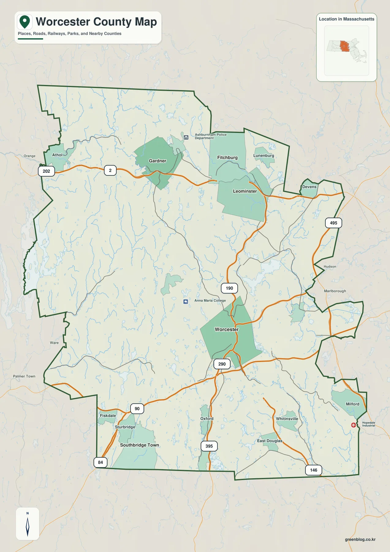
Across the north, Route 2 is the strongest east-west reference. It enters the county near Athol, continues through the Gardner area, and reaches the Fitchburg-Leominster side before the county approaches Middlesex County. The space between these centers is not filled by one uninterrupted city. Instead, broad interior areas with smaller roads, reservoirs, ponds, and wooded-looking terrain remain between the highlighted communities. This pattern is useful when explaining why northern Worcester County has several distinct centers rather than a single continuous strip of development.
I-190 provides a different kind of connection. It runs from the Leominster area south toward Worcester, tying the northern cluster to the county’s largest city. I-495, by contrast, appears near the eastern edge around the Devens side of the map and serves as a useful marker for the county’s relationship to the outer Boston region. Comparing the two routes makes the geography easier to understand: I-190 is an internal north-south link, while I-495 sits much closer to the county’s eastern margin. The map is intended for regional orientation, so current closures and travel times should be checked with up-to-date transportation sources.
The southwestern corner has another recognizable road pattern. I-90 crosses east-west near Sturbridge and Fiskdale, while I-84 enters from Connecticut and meets the Massachusetts Turnpike in the Sturbridge area. Southbridge Town lies farther south, away from the northern Route 2 cities and the central Worcester road cluster. This arrangement helps explain why the southwestern part of the county feels geographically distinct: it is oriented toward a major interstate junction and the Connecticut border rather than toward the northern Fitchburg-Leominster corridor.
South of Worcester, I-395 passes through the Oxford area and continues toward Connecticut. Farther east, Route 146 runs near Whitinsville and East Douglas on its way toward Rhode Island, while Milford occupies the southeastern protruding section of the county. These routes do not simply radiate in identical directions from Worcester. They serve different parts of a large county, and the southeastern area also overlaps with the Blackstone River system that becomes much clearer on the water map.
The western and northwestern sections contain fewer large highlighted places. Athol is the most visible northern reference near Route 2, while long stretches of the county boundary continue south through areas with many small waterways. Nearby labels outside the border, including Orange, Ware, and Palmer Town, help establish the county’s position relative to Franklin, Hampshire, and Hampden counties. Because some surrounding places are shown for context, the dark green county boundary should always be used to distinguish Worcester County from neighboring areas.
The general map is therefore the most balanced first view of Worcester County. It combines municipal centers, route numbers, selected facilities, nearby counties, and the county outline in one frame. Starting with Worcester, then tracing north to Route 2, southwest to I-84 and I-90, and southeast toward I-395 and Route 146 gives a much clearer sense of scale than focusing on the city of Worcester alone. The next map removes much of that detail so the locations of five selected population centers stand out more clearly.
Five selected centers reveal a split between Worcester, the north, and the southwest
The city-distribution map highlights Worcester, Leominster, Fitchburg, Gardner, and Southbridge Town. Worcester is marked first and sits slightly south of the county’s middle. Leominster and Fitchburg form a close northern pair, Gardner lies farther west, and Southbridge Town is isolated in the southwest. That arrangement immediately shows that the county’s important population centers are not concentrated in one corner. They are distributed across the central, northern, and southwestern parts of a very large interior county.
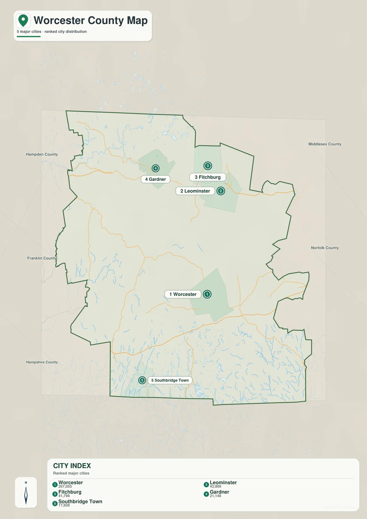
The CITY INDEX printed on the map lists Worcester at 207,055, Leominster at 43,909, Fitchburg at 41,798, Gardner at 21,148, and Southbridge Town at 17,928. Those figures are best treated as values associated with the dataset used to produce this map rather than as a guarantee of the latest official population estimate. Population totals can change with each Census release or annual estimate. For this map, the more durable information is the spatial relationship among the five points and the rank order shown in the image.
Worcester’s position becomes especially meaningful when compared with the general road map. It sits near the meeting area of I-290, I-190, I-90, and I-395, so the largest highlighted center also occupies the strongest transportation node on the page. The simplified city view strips away most road labels and background communities, making Worcester’s central role visually obvious. For a presentation that only needs to show where the county’s major city sits in relation to other selected centers, this version is much cleaner than the detailed base map.
Leominster and Fitchburg appear close together in the north, but the general map confirms that they are distinct urban areas connected by the Route 2 corridor. I-190 comes south from the Leominster side toward Worcester, while Gardner remains farther west along Route 2. This creates a northern sequence that can be explained without implying that the three cities form a single municipality. Gardner is particularly useful as a western anchor because it shows how far the highlighted northern urban pattern extends away from the Leominster-Fitchburg pair.
Southbridge Town is the outlier among the five selected places. It sits in the southwest near Sturbridge and the I-84/I-90 junction rather than near Worcester or the northern Route 2 cities. On the simplified map, that separation is unmistakable. On the detailed map, the surrounding transportation network explains why the town belongs to a different part of the county’s geography. Showing both views together helps distinguish simple point distribution from the road system that connects those points.
Places such as Athol, Milford, Oxford, Whitinsville, and Lunenburg do not appear as ranked city points on this particular map. Their absence should not be read as a statement about local importance. The image is a selected-city comparison rather than a complete municipal inventory. When a project requires a fuller set of community names, route numbers, or nearby landmarks, the general map is the better choice. When the question concerns reservoirs, rivers, and terrain, the water map adds information that neither of the first two views can show clearly.
The city map also does not measure road mileage or travel time between the points. A short visual separation can translate into a longer drive depending on route geometry, terrain, and current traffic. Trips such as Gardner to Worcester or Southbridge Town to Fitchburg cross substantial portions of the county, so they should not be estimated from point spacing alone. This image works best as a quick distribution diagram, while route planning should rely on current navigation and transportation information.
From Wachusett Reservoir to the Blackstone River, water divides the county into several systems
The terrain-and-water reference map changes the emphasis completely. Roads recede into the background and a dense network of streams, ponds, rivers, and reservoirs becomes visible. Wachusett Reservoir is the largest easily recognizable inland water body near the east-central part of the county. The N Nashua River is labeled farther north, the Ware River and Long Pond appear to the west, and the Quaboag River and Quaboag Pond stand out in the southwest. Farther south and southeast, the Quinebaug, French, Mumford, Blackstone, and Mill rivers mark several different drainage directions.
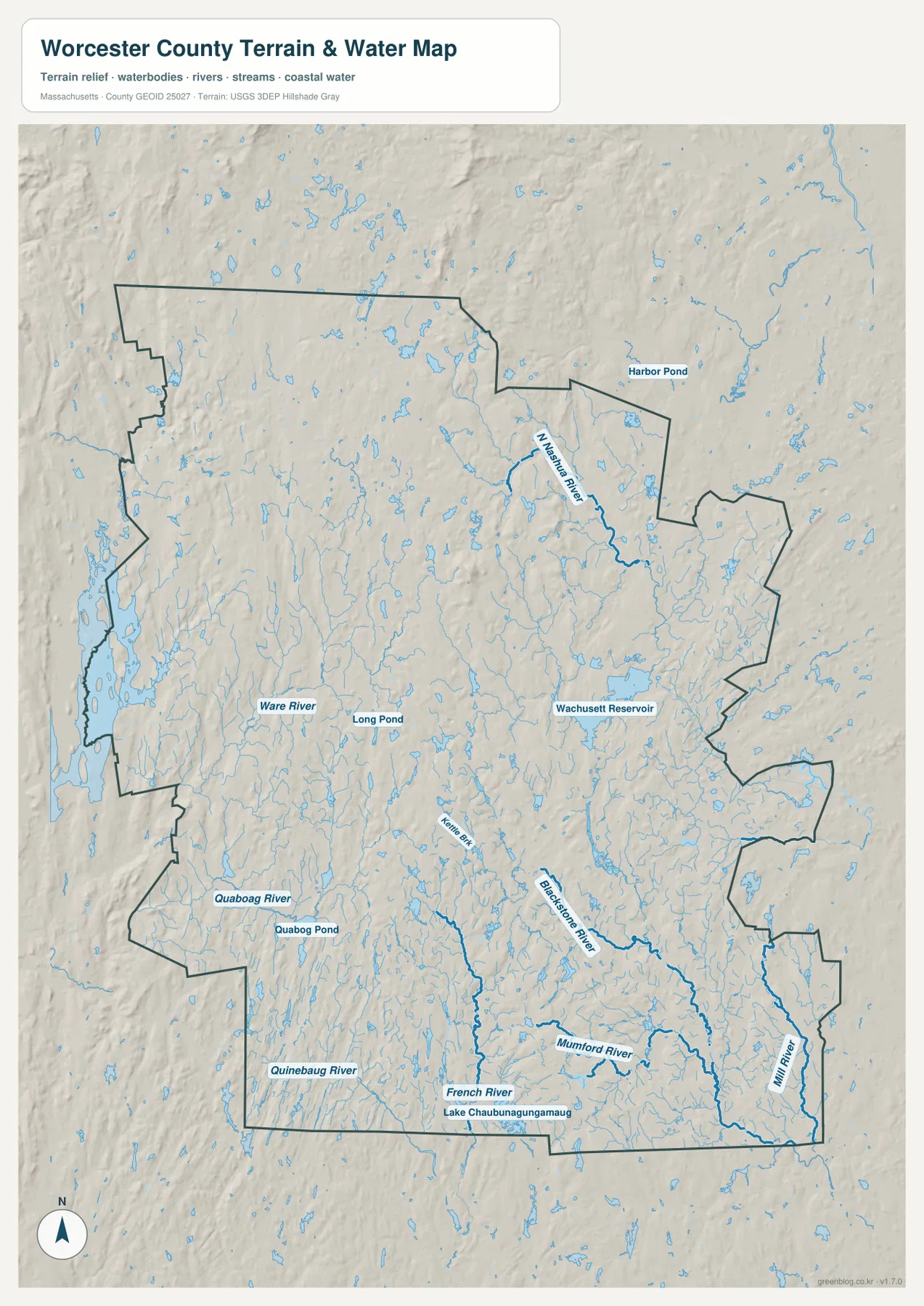
Wachusett Reservoir is the strongest landmark on this map because its broad water surface is easy to distinguish from the many smaller ponds. It lies northeast of Worcester and helps orient the east-central part of the county. Massachusetts’ official Wachusett Reservoir page describes the reservoir as part of the Commonwealth’s major water-supply system, which gives useful context for why the water body is regionally significant. This map, however, does not show water-quality conditions, protected-access rules, depth, or infrastructure, so those topics should be checked through official reservoir information.
North of the reservoir, the N Nashua River is shown as a winding blue line, with Harbor Pond and many smaller waters nearby. Comparing this area with the general map places the river system near the Fitchburg-Leominster part of the county. That comparison is valuable because roads and waterways do not follow identical paths. The transportation map explains how the northern cities are connected, while the water map shows the natural channels that cross and separate parts of the same developed region.
Western Worcester County looks relatively sparse in terms of large city labels, yet the water map reveals a dense interior of streams and ponds. The Ware River and Long Pond are labeled in the west-central area, and the Quaboag River and Quaboag Pond appear farther southwest. This is a useful reminder that an area with fewer large roads or cities is not geographically empty. The terrain background and numerous blue features show an interior landscape broken into many small watersheds and low ridges.
The southern half contains an especially varied collection of named waterways. The Quinebaug River appears in the southwest, the French River crosses the south-central area, and Lake Chaubunagungamaug is labeled near the southern border. Kettle Brook is also visible closer to the Worcester side. These features should not be treated as parts of one simple river flowing in a single direction. They belong to different drainage systems, which helps explain why the county’s southern landscape cannot be reduced to one valley or one major watercourse.
In the southeast, the Blackstone River becomes one of the strongest named waterways. The Mumford River approaches from the west and northwest, while the Mill River appears closer to the eastern edge. Returning to the general map places these waters near the Route 146, Whitinsville, East Douglas, and Milford side of the county. The combination of road and water views makes the geography more understandable than either image alone, because human travel corridors and natural drainage lines cross the same region in different patterns.
The shaded terrain suggests that Worcester County is not an extensive flat plain. Subtle ridges, depressions, and stream valleys repeat across the county, especially in the broad western and northern interior. The relief background is useful for understanding the overall shape of the land, but it does not include contour labels or survey points. Exact elevation, slope, or site-specific engineering measurements should come from dedicated elevation data such as the USGS 3D Elevation Program rather than from this generalized reference image.
Blue lines and water polygons also should not be interpreted as flood zones, measured river widths, navigation channels, or water-quality classes. Line thickness is a cartographic choice made for legibility. A stream drawn prominently on the page is not necessarily wider or more navigable than a nearby stream shown with a similar symbol. The useful question here is where the main named rivers and reservoirs sit in relation to cities and county boundaries, not what the present hydrologic conditions are at a specific address.
Why northern Route 2 and the southern river country feel different on the maps
One of the clearest county-wide contrasts appears between the northern Route 2 corridor and the southern half. In the north, Gardner, Fitchburg, and Leominster form a recognizable sequence of highlighted centers, and I-190 connects the Leominster side toward Worcester. In the south, settlements such as Southbridge Town, Oxford, Whitinsville, and East Douglas are more widely separated, while I-84, I-90, I-395, and Route 146 point in different directions. The county therefore does not have one transportation pattern repeated from top to bottom.
The water systems reinforce that difference. The north-central area is visually anchored by the Nashua River and Wachusett Reservoir, while the west contains the Ware and Quaboag systems. In the south, the Quinebaug, French, Mumford, and Blackstone rivers create several named corridors. Looking only at the road network can make Worcester appear to organize the entire county around a single central city. Adding the hydrology shows a more complex interior in which natural drainage divides the county into multiple geographic zones.
For a printed report or classroom handout, the general map works well as the first page because it establishes county shape, surrounding counties, roads, and major places. The city-distribution view is better for a concise comparison among Worcester and four other selected centers. The water reference becomes most useful when a discussion turns to Wachusett Reservoir, river valleys, or the contrast between developed centers and the many streams that cross the interior. Using the images in that sequence keeps each page focused rather than forcing every label onto one crowded map.
The county boundary on these images is intended for broad geographic orientation, not parcel-level or legal decisions. The same caution applies to roads and waterways. A highway label does not guarantee current access or traffic conditions, and a river line does not identify flood risk at a property. Travelers should use current transportation tools, while survey, real-estate, flood, water-management, and engineering questions require the corresponding official datasets and professional sources.
Choosing the right Worcester County map for roads, cities, or waterways
Use the general county map when the main goal is orientation. Starting at Worcester, follow I-190 north to the Leominster-Fitchburg area and Route 2 west toward Gardner and Athol. In the south, compare I-90 with I-395, I-84, and Route 146 to distinguish Sturbridge, Southbridge Town, Oxford, Whitinsville, and the southeastern communities. Because neighboring counties and several outside place labels are also present, this view is the easiest one for explaining where Worcester County sits within central Massachusetts.
Choose the city-distribution map when the key question is how five selected centers relate to one another. Worcester stands alone near the middle, Leominster and Fitchburg form a close northern pair, Gardner extends the northern pattern westward, and Southbridge Town anchors the southwest. Choose the terrain-and-water map when the discussion instead concerns Wachusett Reservoir, the Nashua and Ware rivers, the Quaboag and Quinebaug systems, or the Blackstone River in the southeast. Each view answers a different geographic question with less visual clutter.
The web images are convenient for quick reading, but the downloadable archive contains the original high-resolution JPG versions for larger viewing and printing. The package includes the general county map, the selected-city distribution map, and the terrain-and-water reference map. That makes it possible to use a detailed base map for a report, a cleaner city graphic for a slide, and the hydrology view for a section focused on rivers and reservoirs while keeping all three materials consistent with the same county.
Frequently Asked Questions
Can I see Wachusett Reservoir and the Blackstone River on the same map?
Yes. The terrain-and-water reference map places Wachusett Reservoir in the east-central part of the county and the Blackstone River in the southeast, making their relative positions easy to compare. It does not show reservoir access rules, water quality, flood limits, or river depth, so those subjects should be checked with current official sources.
Are the five places on the city map all of the cities and towns in Worcester County?
No. The city-distribution image is a selected ranking that highlights Worcester, Leominster, Fitchburg, Gardner, and Southbridge Town. Many other communities, including Athol, Milford, Oxford, Whitinsville, and Lunenburg, are not represented as ranked points. Use the general county map when you need a broader set of place names and road references.
Which map best shows how Route 2 and I-90 are separated across the county?
The general county map is the best choice. Route 2 crosses the northern part of Worcester County through the Athol-Gardner-Fitchburg-Leominster corridor, while I-90 crosses the southern half near Sturbridge and south of Worcester. Seeing both routes in one frame makes the county’s north-south scale and its different transportation zones much easier to understand.
Map File Information
The ZIP contains the original high-resolution JPG files for the Worcester County general map, selected-city distribution map, and terrain-and-water reference map described on this page.
- Included Files: General county map, selected-city distribution map, terrain-and-water reference map
- File Type: JPG
Related Maps
Sources and References
These official resources are useful for checking Worcester County boundaries, waterways, Wachusett Reservoir information, and regional administrative context.
- MassGIS Data – Counties
- Mass.gov – Wachusett Reservoir
- Mass.gov – MassDEP Central Regional Office
- U.S. Census Bureau TIGER/Line Shapefiles
- USGS National Hydrography
Green Map creates custom-edited map images using open geographic data sources such as geoBoundaries, Natural Earth, OpenStreetMap, and government open data. These maps are edited visual materials, not raw data files, and are provided for education, documents, presentations, and graphic reference.