Butler County in southeast Missouri is a place where several geographic patterns meet in a relatively small area. Poplar Bluff forms the main urban and road center, U.S. 60 and U.S. 67 meet near the city, rugged Ozark foothills rise to the northwest, and broad lowlands open to the south and east. This page combines a county road-and-place map, a simplified city-connections map, a terrain-and-water map, and an elevation map. The same maps are also available as original high-resolution JPG files in one downloadable ZIP for closer inspection and print use.
The strongest visual contrast is the change in terrain around Poplar Bluff. North and west of the city, narrow valleys cut through a higher, more dissected landscape. Southeast of the city, the surface becomes much flatter and lower. Poplar Bluff’s official comprehensive plan describes the city as lying at a significant natural transition between the Ozark Foothills and the lowland Mississippi River Basin. The supplied elevation map shows that transition clearly, with higher brown and yellow terrain in the northwest giving way to broad green lowlands across most of the south and east.
Waterways reinforce the same pattern. The Black River approaches Poplar Bluff through the northern part of the county, while the eastern county line follows the winding St. Francis River. Farther south, the low plain contains the Dan River, Big Hunting Slough, several drainage ditches, and small lakes. The road map by itself can make the southern half look simple because long road segments cross the flat terrain, but the water and elevation maps reveal a dense network of channels and a very different landscape from the hillier northwest.
Table of Contents
U.S. 60 and U.S. 67 Meet at Poplar Bluff Before Roads Fan South
The general county map is anchored by Poplar Bluff, which occupies a large developed area slightly west of the county’s north-central zone. U.S. 60 runs east-west through the city area, while U.S. 67 approaches from the north and continues through the Poplar Bluff corridor. Route 160 comes in from the west near Fairdealing and reaches Poplar Bluff, and U.S. 60 continues east toward Fiske. With several numbered routes converging in one place, Poplar Bluff is the easiest starting point for locating the rest of Butler County.
South of the city, the road pattern spreads into longer, more widely spaced routes. Route 158 crosses the central-western part of the county near Harviell, Route 51 angles southeast toward Qulin, and Route 53 crosses the lower eastern area. Route 142 provides another east-west reference near the southern part of the county. This change from a concentrated network around Poplar Bluff to long rural road segments farther south fits the terrain: the southern and southeastern lowlands are much flatter than the hill country north and west of the city.
Several smaller communities help divide the county into recognizable areas. Fairdealing and Harviell lie to the west and southwest of Poplar Bluff, while Fiske appears near the eastern side along the U.S. 60 corridor. Broseley is farther southeast, Qulin lies in the lower eastern portion, and Neelyville provides a useful landmark in the southwest. The pattern is not one of several similarly sized towns distributed evenly across the county. Instead, one large urban center is surrounded by smaller places separated by open rural land and extensive drainage networks.
The eastern boundary is especially distinctive. Rather than following a straight survey line, it bends repeatedly with the St. Francis River from the northeast toward the southeast. The Missouri statute describing Butler County’s legal boundary uses the middle of the main channel of the St. Francis River as the eastern line. That explains the irregular edge visible east of Fiske and Qulin. The southern state line and portions of the western side are much straighter, making the river-defined eastern outline easy to recognize.
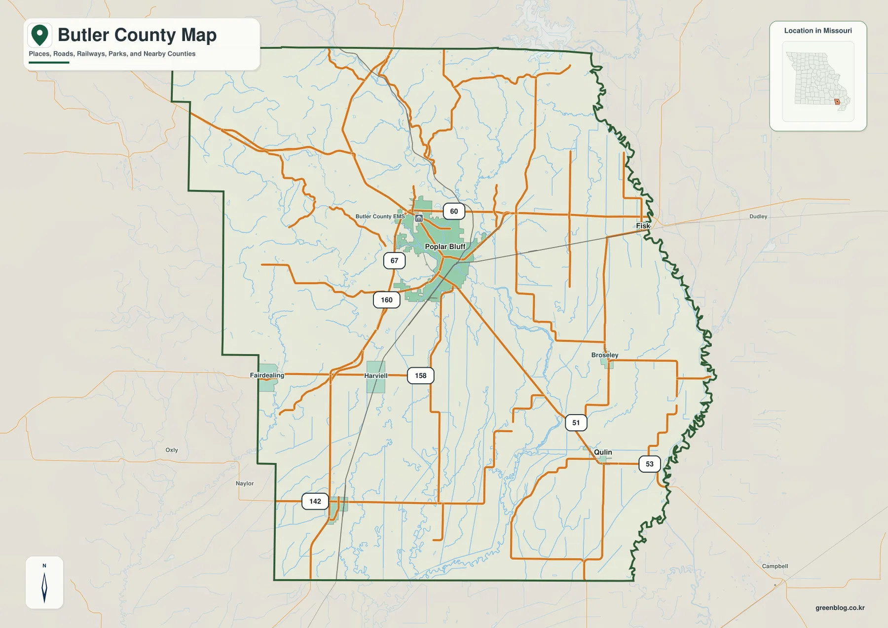
This is the most useful map for a first countywide orientation because it combines the county outline, major communities, and numbered roads. It makes it easy to see how travel corridors extend from Poplar Bluff toward Fiske in the east, Qulin in the southeast, and Fairdealing or Neelyville toward the west and southwest. It should not be treated as a live navigation product, however. Construction, closures, and local access can change, so current transportation information is still needed for actual driving.
Poplar Bluff as the Hub for Fiske, Qulin, and Neelyville
The city-connections map removes much of the road detail and emphasizes the relative positions of four selected communities. Poplar Bluff is identified as the hub, with Fiske to the east, Qulin to the southeast, and Neelyville to the southwest. The map labels straight-line distances of about 11 miles from Poplar Bluff to Fiske, 14 miles to Qulin, and 15 miles to Neelyville. Those values are not driving distances. Actual road travel follows highways, local roads, bridges, and turns, so a route can be longer than the straight line shown here.
Fiske is the easiest of the three smaller places to connect with the general road map because it sits near U.S. 60 close to the county’s eastern side. Qulin is farther south near the Route 51 and Route 53 area, while Neelyville occupies the southwestern part of the county. The three communities therefore form a useful directional set around Poplar Bluff: one to the east, one to the southeast, and one to the southwest. That simple arrangement is much easier to see on this map than on the more detailed road map.
The hub pattern also illustrates how strongly Poplar Bluff dominates the settlement geography represented here. Most of the other named places are small and widely separated, while Poplar Bluff has the large developed footprint and the densest road network. This does not make the city-connections map a complete list of every community in Butler County. It is a simplified reference that highlights selected places and their relative spacing, which is useful for a presentation, worksheet, or quick geographic comparison.
The connecting lines should never be mistaken for actual roads. A direct line from Poplar Bluff to Qulin, for example, crosses the landscape without showing the turns required by the real road network or the exact places where waterways can be crossed. For travel planning, use the general map to identify U.S. 60, Route 51, Route 53, and other routes, then confirm the current route with an up-to-date navigation or transportation source.
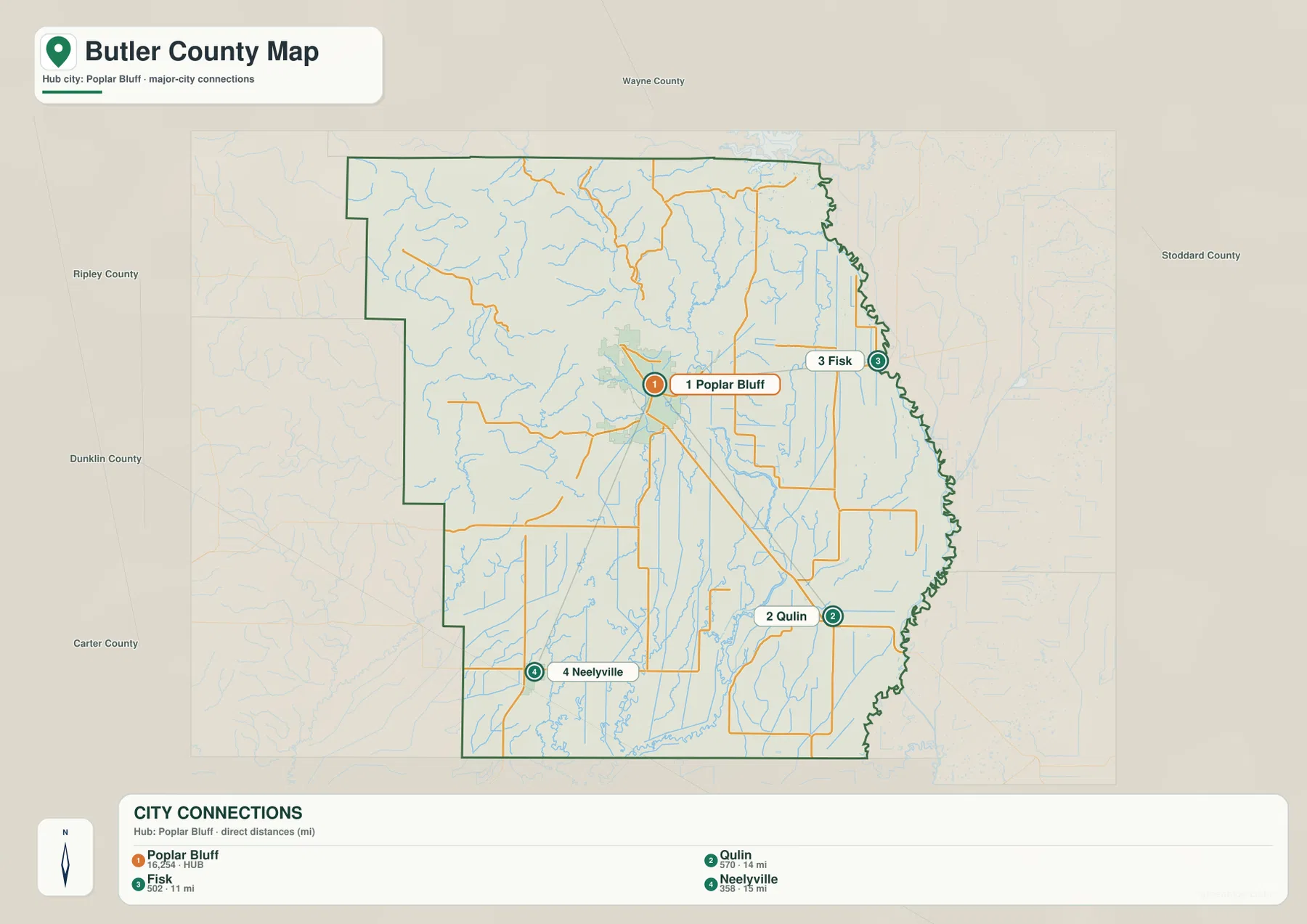
Neighboring county names around the outside of the map provide another layer of regional orientation, but the main purpose remains the relationship among the four selected Butler County communities. Exact population values or legal municipal status can change over time and should be checked against current Census and local-government information. The strength of this map is visual simplicity rather than detailed statistics.
Black River, St. Francis River, Sloughs, and Lowland Drainage
The terrain-and-water map shifts attention away from roads and toward the county’s drainage. In the north, the Black River is the most prominent named channel. It approaches through the hillier part of the county, with Cane Creek and other tributaries joining through narrow valleys. Tenmile Creek is another clearly labeled stream on the western side. Because the map includes shaded relief, these streams can be seen occupying lower corridors between ridges instead of appearing as isolated blue lines.
Near the northern interior, Lake Ockloma and Carpenter Lake are labeled, and Myers Lake appears farther west. South of Poplar Bluff, the drainage pattern changes as the terrain becomes flatter. The Dan River, Big Hunting Slough, Murphy Ditch, Stinking Ditch, and other long channels extend across the lowland. Many of these features are straighter and more elongated than the small creeks in the northwest, which reflects both the flat setting and the long history of drainage modification in southeast Missouri’s former wet lowlands.
The eastern county edge follows the St. Francis River. Even where the river name is not printed prominently across the map, the boundary itself traces a continuous series of bends. This is not an accidental cartographic shape: Missouri’s statutory county description specifies the middle of the St. Francis River’s main channel as the boundary. That river-defined edge is especially noticeable east of Fiske and Qulin and contrasts with the straight southern state line.
The southern lowland also contains Allred Lake and a dense web of smaller channels. University of Missouri Extension describes the southeast Missouri Delta region, including Butler County, as part of the northern Mississippi River Alluvial Valley, where broad low plains were historically associated with extensive wetland and swamp environments before large-scale drainage and agricultural development. The supplied map reflects that history through the combination of natural rivers, sloughs, lakes, and engineered drainage ditches.
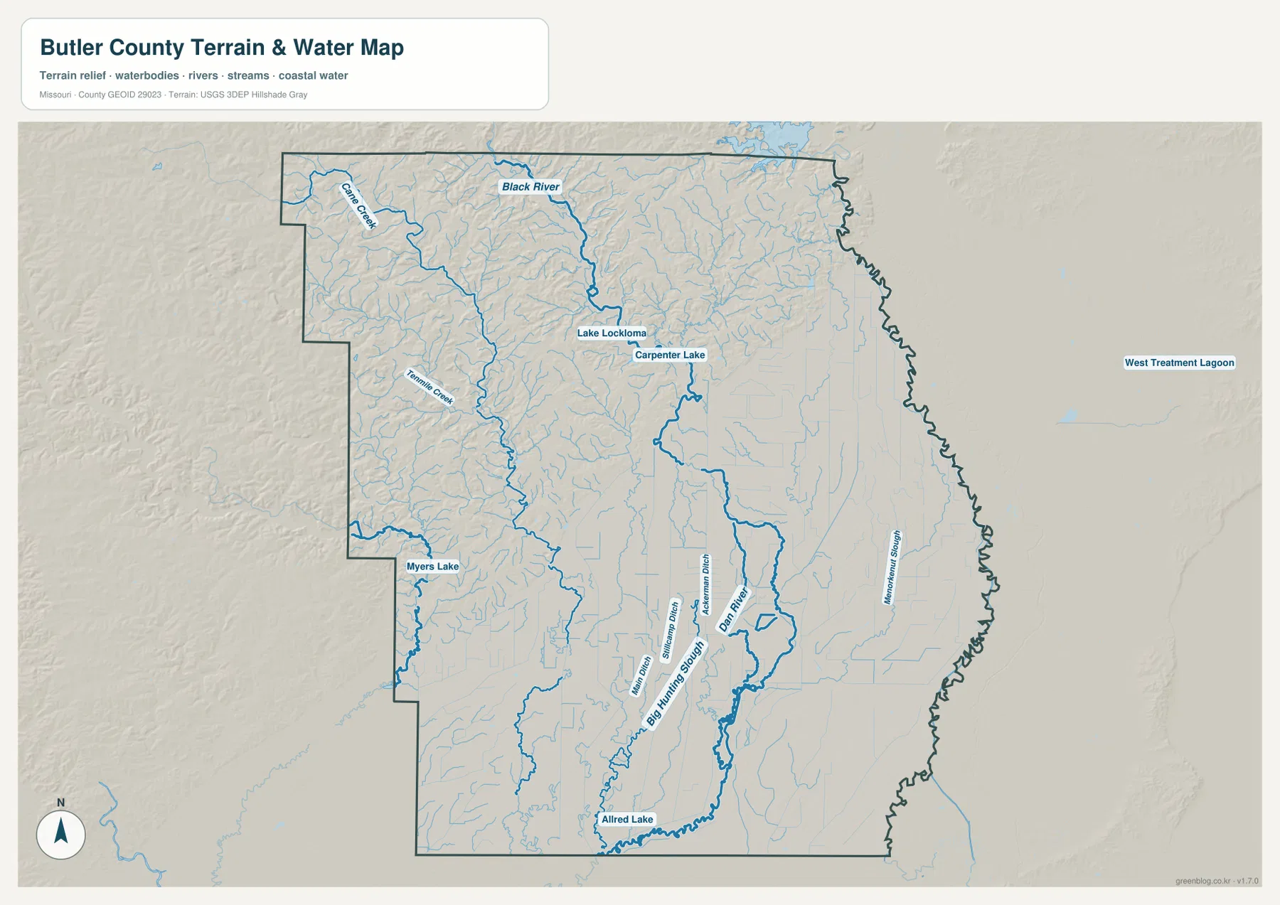
This water map is a general geographic reference, not a flood-regulation or navigation product. It does not show FEMA flood zones, current river stages, levee condition, parcel boundaries, or legally controlling wetland limits. It is useful for seeing where major named waterways and lakes lie and how channels relate to the terrain. Decisions involving flood insurance, development, emergency conditions, or property regulation should be based on current official sources.
A Sharp Elevation Change from Ozark Foothills to Southeast Lowland
The elevation map makes Butler County’s two-part landscape unmistakable. The northwest contains tightly packed ridges and valleys shown mostly in brown, tan, and yellow. Around and north of Poplar Bluff, tributaries cut narrow green corridors through the higher ground. Moving southeast from the city, the rugged texture quickly fades and a broad green surface covers most of the lower county. Few Missouri county maps show such an immediate transition from dissected hill country to a wide, nearly level lowland within the same boundary.
The legend gives an actual elevation range of roughly 62 to 233 meters, with a mean near 114 meters. The displayed color ramp is locally scaled to emphasize differences inside the county, so the darkest brown should not be interpreted as extremely high mountain terrain in a statewide sense. The useful message is relative: the northwest is much higher and more rugged than the south and east, and the transition occurs close to Poplar Bluff.
Poplar Bluff’s official comprehensive plan describes the bluff as a major natural landmark separating the Ozark Foothills from the lowland Mississippi River Basin. That description matches the supplied elevation surface very closely. West and northwest of the city, ridges remain prominent. Southeast of the city, the colors drop into the green lowland and remain relatively uniform for long distances. The road map alone cannot explain this contrast, but the elevation map makes the city’s position at the terrain break immediately understandable.
The lowland is not perfectly featureless. Small depressions and subtle corridors follow the Dan River, sloughs, drainage ditches, and the St. Francis River side of the county. In the northwest, by contrast, almost every tributary occupies a visibly incised valley between higher ridges. Comparing the water and elevation maps shows how stream form changes with terrain: short branching creeks dominate the dissected hills, while long channels and drainage lines become more common across the flat southern plain.
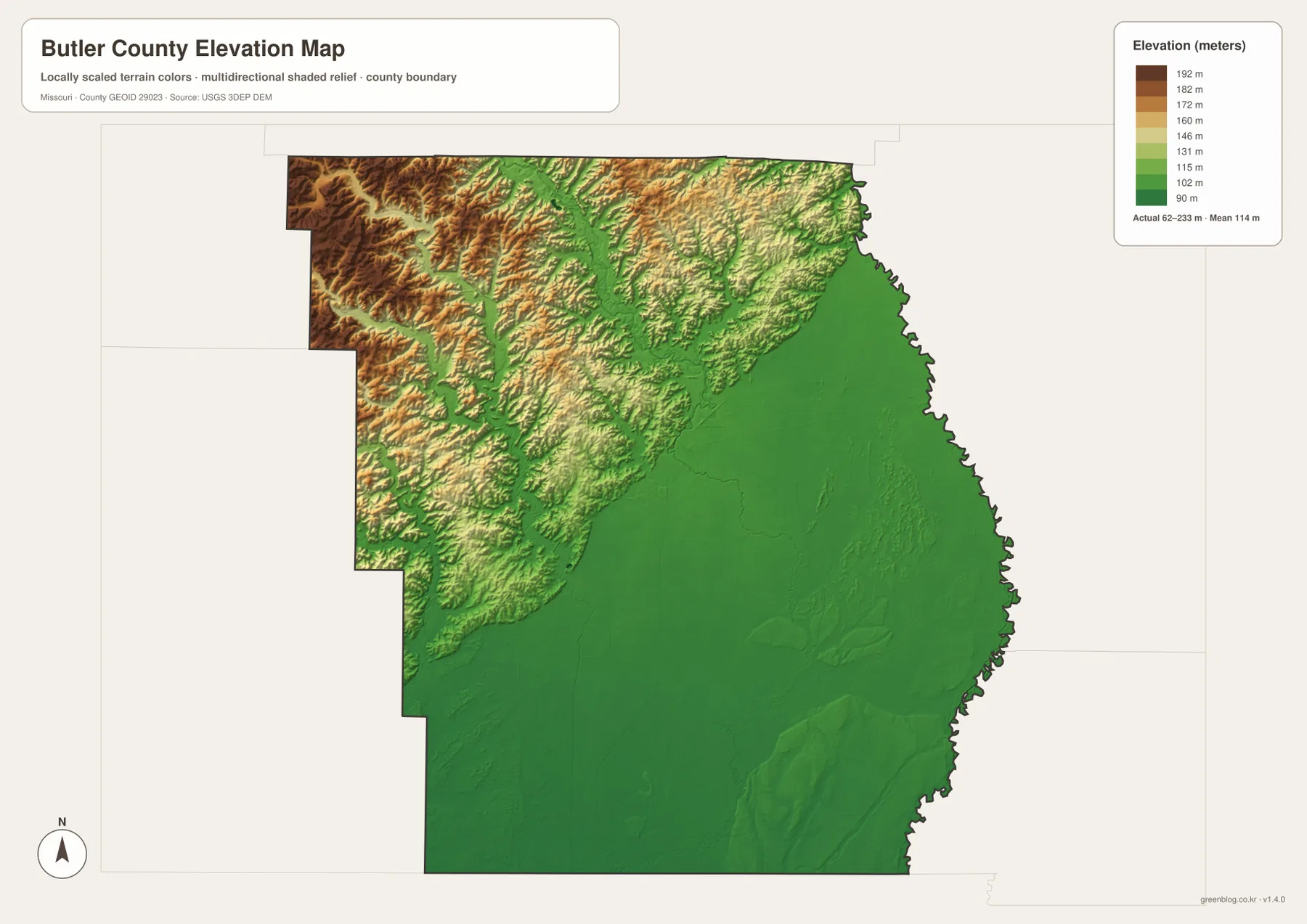
This elevation surface is intended for county-scale geographic comparison. It is not a survey-grade source for individual lots, construction design, drainage engineering, or precise spot elevations. For those needs, the USGS 3D Elevation Program or a professional survey should be used. For general map reading, however, the surface is very effective at showing the terrain break at Poplar Bluff, the hillier Black River approaches, and the broad lowlands toward the St. Francis River and southern county line.
Choosing the Map for Roads, Communities, Water, or Relief
For a first look at Butler County, the general map is the most useful because it combines Poplar Bluff, U.S. 60, U.S. 67, state routes, smaller communities, and the county boundary. It answers basic questions such as where Fiske lies in relation to Poplar Bluff, which corridor leads toward Qulin, and how the irregular St. Francis River boundary shapes the east side. When the goal is only to compare the selected communities, the city-connections map is cleaner and makes the east-southeast-southwest arrangement around Poplar Bluff obvious.
For natural geography, the terrain-and-water map and elevation map work best together. The water map names the Black River, Cane Creek, Tenmile Creek, Dan River, Big Hunting Slough, lakes, and drainage ditches, while the elevation map explains why those channels look different in the northwest and southeast. The pairing is especially useful around Poplar Bluff, where higher Ozark foothills end and the low plain begins.
The original JPG files are 3638 by 2572 pixels each, giving more room to enlarge small place names, creek labels, and drainage details than the WebP images displayed in the article. They are suitable for general reference, educational materials, and print preparation. They should not replace current official products for road closures, flood zones, parcel boundaries, zoning, legal boundary disputes, or engineering work.
A particularly useful Butler County pairing is the general road map with the elevation map. The first shows why Poplar Bluff is the transportation center, and the second shows why the city also sits at an important physical transition. Adding the water map then connects the Black River and lowland drainage system to that terrain change. Using the maps in this order gives a clear progression from human geography to physical geography without forcing every type of information onto a single image.
Frequently Asked Questions
Why is northwest Butler County high and rugged while the southeast looks so flat?
Poplar Bluff lies close to the transition between the Ozark Foothills and the lowland Mississippi River Basin. The elevation map shows tightly dissected higher terrain to the northwest and a broad low green plain to the southeast. Poplar Bluff’s official comprehensive plan describes the bluff as an important natural landmark at that transition. The map’s actual elevation range is about 62 to 233 meters, but precise site elevations should be checked with detailed USGS data or a survey.
Are the 11 miles to Fiske, 14 miles to Qulin, and 15 miles to Neelyville driving distances?
No. The city-connections map labels straight-line distances from Poplar Bluff to the three selected communities. Real driving routes follow U.S. 60, Route 51, local roads, and available bridges, so the traveled distance can be longer. Use the city map for relative direction and spacing, then use the general road map and a current navigation source for actual travel planning.
Can the Black River and drainage map be used to determine flood risk?
No. The terrain-and-water map is a general reference for the Black River, Dan River, Big Hunting Slough, lakes, and drainage channels. It does not contain regulatory FEMA flood zones, real-time river stages, levee information, parcel boundaries, or legal wetland determinations. Use it to understand the location of waterways and surrounding terrain, but use current FEMA and local-government information for flood, insurance, development, or safety decisions.
Map File Information
The ZIP contains the original high-resolution JPG files for the county map, city-connections map, terrain-and-water map, and elevation map shown in this article. The originals are larger than the on-page WebP images and are suitable for closer viewing and print preparation.
- Included Files: 4 maps
- File Type: JPG
Related Maps
Sources and References
- City of Poplar Bluff Comprehensive Plan: official background on Poplar Bluff’s location, U.S. 60 and 67, and the transition between Ozark foothills and lowlands.
- University of Missouri Extension – Delta Soils of Southeast Missouri: background on the alluvial lowlands and drainage history of southeast Missouri, including Butler County.
- U.S. Census Bureau TIGER/Line Shapefiles: official geographic boundary data.
- USGS National Hydrography: official hydrography information for rivers, streams, lakes, and related water features.
- USGS 3D Elevation Program: official elevation and terrain-surface data.
Green Map creates custom-edited map images using open geographic data sources such as geoBoundaries, Natural Earth, OpenStreetMap, and government open data. These maps are edited visual materials, not raw data files, and are provided for education, documents, presentations, and graphic reference.