Buchanan County sits in northwest Missouri with St. Joseph occupying much of its northwestern corner and the Missouri River tracing a broad, curving western edge. I-29 and U.S. 36 are the clearest transportation references around St. Joseph, while smaller places such as Agency, Easton, De Kalb, Rushville, Faucett, and Lewis and Clark Village are spread across the rest of the county. This page brings together the county boundary and road map, a simplified city-distribution map, a terrain-and-water map, and an elevation map. The same maps are also available as high-resolution JPG files in one downloadable ZIP for closer viewing and print use.
The county has a strong contrast between the urban concentration around St. Joseph and the more open southern and eastern areas. Along the west, the Missouri River produces an irregular boundary with wide bends and low floodplain terrain. On the eastern side, the Platte River and its tributaries form another set of low valleys, while higher ridges occupy much of the ground between the two river systems. Seeing the road, water, and elevation maps together makes it easier to understand why the county does not read as one uniform plain even though the major highways look relatively simple on the general map.
Buchanan County government describes the county as part of Northwest Missouri, bordered by the Missouri River on the west and crossed by Interstate 29 and U.S. Highway 36. Those features are easy to match with the supplied maps. Around St. Joseph, I-29, U.S. 36, U.S. 59, and Route 229 cluster closely, while U.S. 71 and state routes become more prominent toward Faucett, De Kalb, and the southern part of the county. Using St. Joseph and the Missouri River as the first two reference points makes the smaller communities, streams, and elevation changes much easier to locate later.
Table of Contents
St. Joseph, I-29, U.S. 36, and the Curving Western Boundary
The general county map is dominated by St. Joseph in the northwest. I-29 runs north to south beside the city, and U.S. 36 crosses the county eastward toward Easton and Route 31. U.S. 59 angles through the southwestern side of the St. Joseph area and continues toward Rushville and De Kalb, while Route 229 provides another recognizable route on the south side of the city. Because several numbered roads are concentrated in a relatively small area, the map quickly shows why St. Joseph is the practical anchor for reading the rest of Buchanan County.
South of St. Joseph, the road network becomes much less dense. U.S. 59 heads toward the Rushville and De Kalb area, while I-29 and U.S. 71 continue south in the direction of Faucett and Dearborn. Route 116 crosses the southwest and helps place Lewis and Clark Village, Rushville, and De Kalb in relation to one another. Agency lies farther east, close to the central part of the county, and Easton is near the eastern edge. These smaller places are useful landmarks because they divide the county into distinct zones rather than leaving everything outside St. Joseph as an undifferentiated rural area.
The western boundary is one of the most distinctive shapes on the map. Instead of following a straight north-south line, it repeatedly bends inward and outward with the Missouri River. The broad curve west of St. Joseph, the long river edge beside the central-western part of the county, and the lower bend near Lewis and Clark Village create a silhouette that is immediately recognizable. The north, east, and south sides are much straighter by comparison. This difference is especially useful when matching the general map with the water map, where the river itself explains the unusual county outline.
A few major facilities are labeled in and around St. Joseph, including the county courthouse and medical facilities. Those labels help orient the viewer within the largest city, but the map is not intended to replace a detailed street or navigation map. Its main value is the countywide relationship among roads, settlements, and boundaries. For current closures, construction, or turn-by-turn driving information, a current Missouri transportation source should be used instead of treating this static county map as a live traffic product.
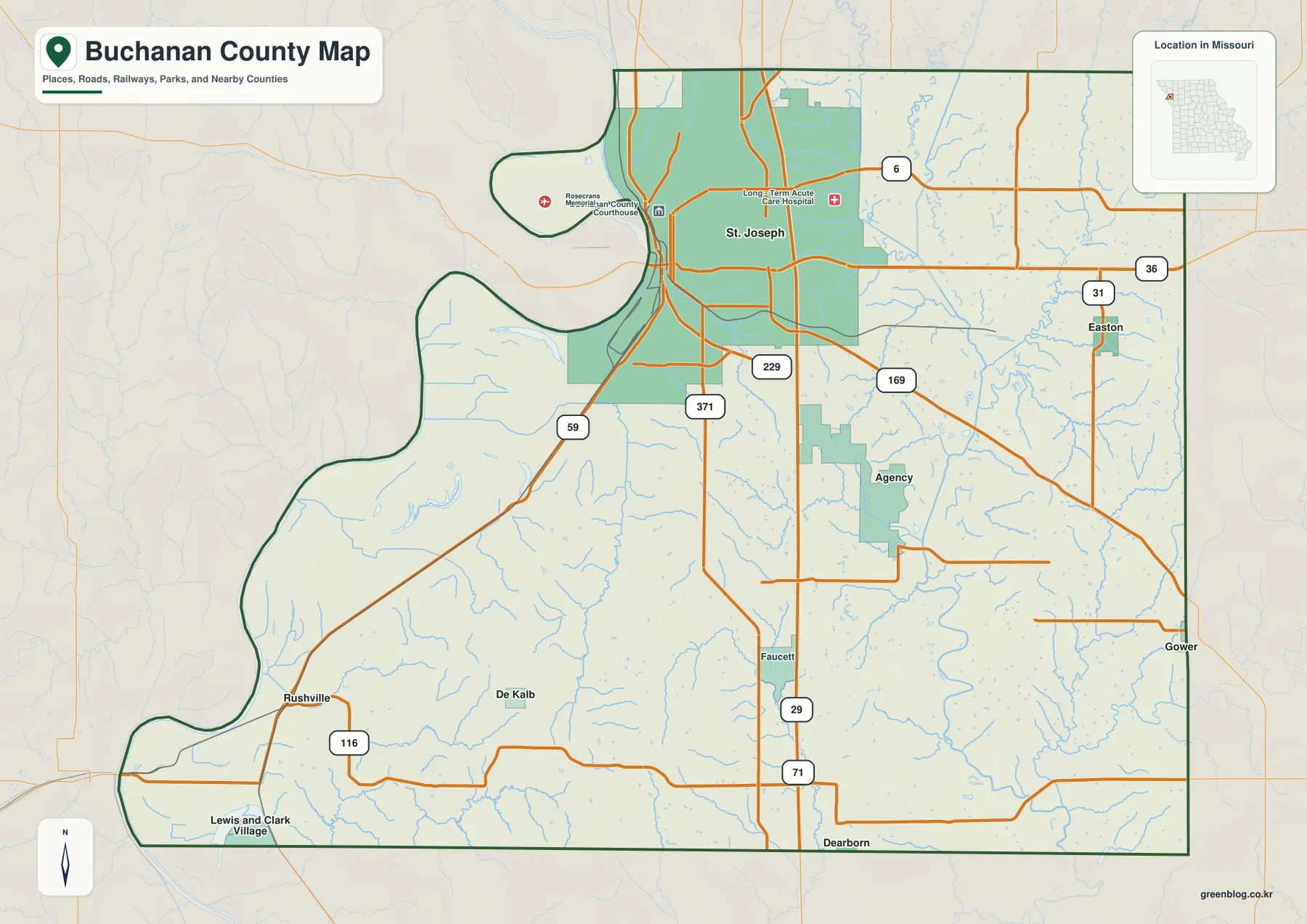
This is the best starting map when the goal is to understand the county as a whole. It shows how the St. Joseph road network opens toward the south, where De Kalb and Faucett sit, and toward the east, where Agency and Easton appear. It also provides the geographic frame for the other maps. The city map removes most road detail, the water map emphasizes drainage and relief, and the elevation map reduces the landscape to relative height. Starting with the general map makes it much easier to recognize the same locations when the information changes.
A Large St. Joseph Core and Smaller Communities Across the County
The city-distribution map strips away much of the road detail so the settlement pattern stands out. In the supplied city index, St. Joseph is ranked first, followed by Agency, De Kalb, Easton, Rushville, and Lewis and Clark Village. The exact numbers are less important here than the visual contrast: St. Joseph occupies a large area in the northwest, while the other five communities appear as much smaller, widely spaced points. That layout makes it clear that Buchanan County is not organized around several similarly sized towns but around one dominant urban center and a set of much smaller communities.
Agency sits southeast of St. Joseph near the middle of the county, while Easton is farther east near the county edge. In the southwest, De Kalb and Rushville are relatively close to one another, and Lewis and Clark Village lies near the far southwestern corner. Those positions create three useful groups for map reading: the St. Joseph urban area in the northwest, Agency and Easton in the central-to-eastern part, and the De Kalb-Rushville-Lewis and Clark Village cluster in the southwest. This grouping is more informative than simply describing every place as south or east of St. Joseph.
The index should be treated as a map aid rather than a current demographic table. It helps identify which places the map maker chose to emphasize and how they are distributed across the county. St. Joseph clearly dominates the settlement pattern, while the remaining communities are separated by larger areas of open land, small roads, streams, and ridges. If an exact population for a particular year is needed, current Census data or a local government source is more appropriate. The strength of this map is geographic comparison, not a precise statistical ranking.
The settlement pattern also becomes more meaningful when compared with the natural landscape. St. Joseph lies close to the Missouri River but extends eastward onto higher ground. Agency and Easton occupy the interior and eastern side, where tributaries of the Platte River cut a dense set of valleys. De Kalb and Rushville are positioned between the Missouri River lowlands and the higher central terrain. The city map alone does not show those elevation differences, but it provides a clean reference for finding each community on the water and elevation maps.
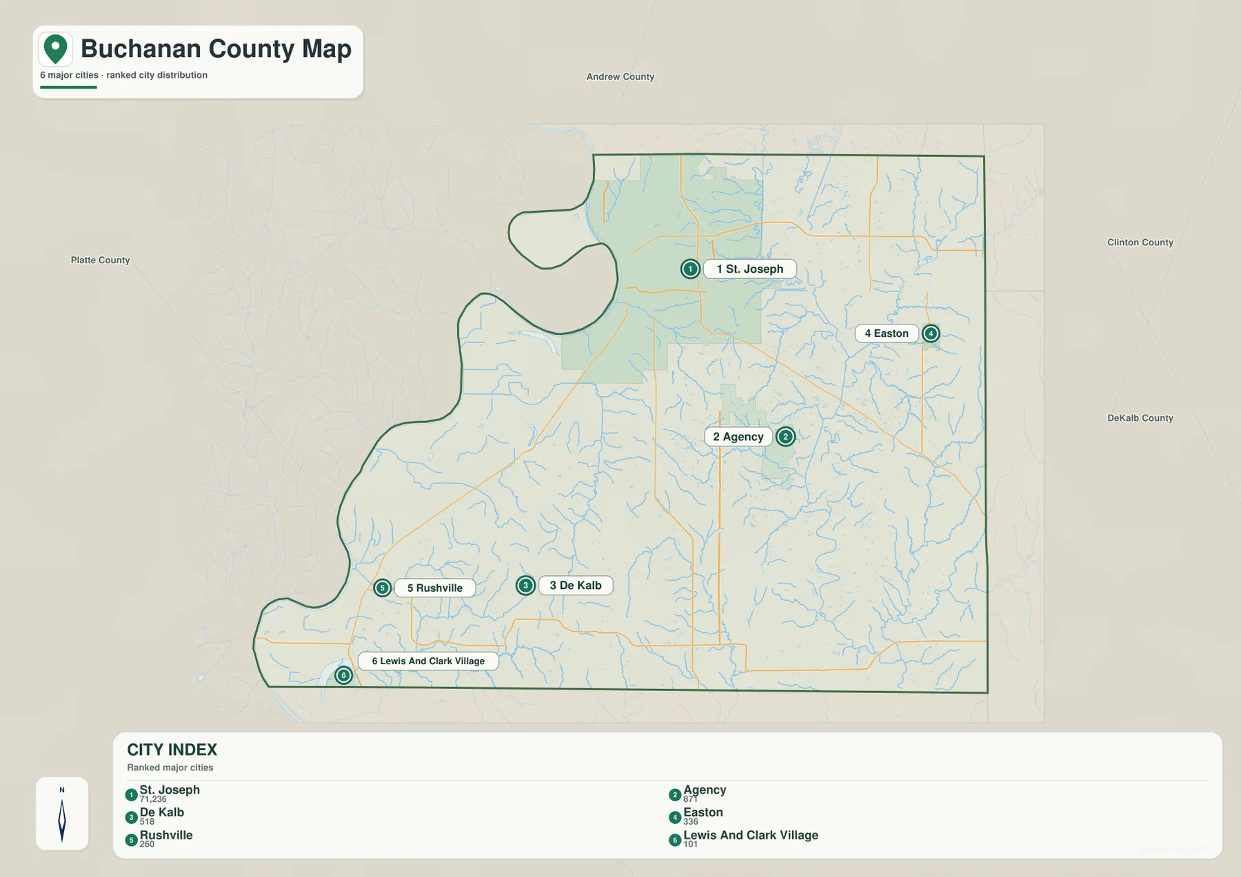
This simplified map works well when a presentation, worksheet, or reference page needs settlement names without the visual weight of every highway and secondary route. For transportation questions, however, the general map remains more useful because it shows I-29, U.S. 36, U.S. 59, U.S. 71, and the state routes that connect the communities. The two maps complement each other: one keeps the county’s human geography visually simple, while the other explains how those places are linked by roads.
Missouri River Bends, Platte River Valleys, and Interior Creeks
The terrain-and-water map shifts attention from roads to rivers, creeks, lakes, and relief. The Missouri River defines the western side with a series of broad bends, while the Platte River follows the eastern and southeastern part of the county. In the northeast, Third Fork Platte River appears as another major named channel, and Hundred and Two River crosses the northern side before approaching the Platte River system. Between these larger waterways, many short tributaries cut through the county, showing that the interior is divided into numerous small valleys rather than forming one featureless surface.
Several named lakes are concentrated near the Missouri River side. Lake Contrary sits southwest of St. Joseph, with Muskrat Lake, Horseshoe Lake, Old Mud Lake, and New Mud Lake farther south in the river lowland. Lewis and Clark Lake appears near the southwestern edge of the county. Their close spacing helps illustrate how complex the Missouri River margin is. The western lowland includes modern channels, former channel features, lakes, and wet depressions associated with a river that has shifted across a broad valley over time. The map is useful for locating these water features but does not show real-time water levels or navigability.
Within the county, Contrary Creek and Bee Creek are useful orientation features. Contrary Creek runs toward the western lowland, while Bee Creek occupies the central-southern area and receives numerous smaller tributaries. On the eastern side, many short channels feed toward the Platte River, and Millers Lake and Benner Lake are labeled near that drainage. Comparing these features with Agency, Faucett, and Easton on the road map shows how roads and settlements occupy ridges and valley crossings rather than following a single uniform grid across the landscape.
The shaded relief makes the water pattern easier to understand. The Missouri River and Platte River margins appear broad and low, while the central and southwestern interior shows more pronounced ridges. Small streams occupy the lower cuts between those ridges, with drainage ultimately moving toward one of the larger river valleys. This map should not be used as a flood-zone, parcel, legal-boundary, or navigation map. Its purpose is to show where the major rivers, tributaries, and lakes lie and how their valleys relate to the surrounding terrain.
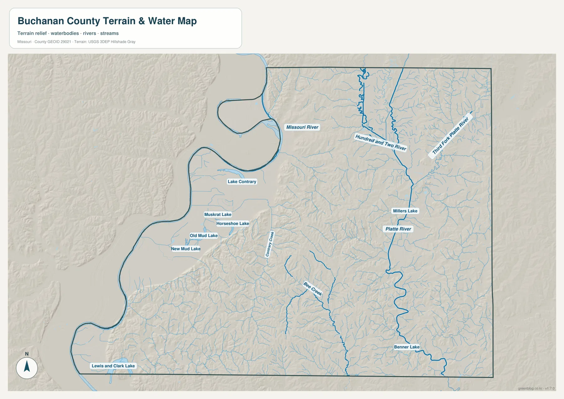
The St. Joseph area is especially interesting when the general and water maps are compared. Roads and development spread across the city, but the water map makes the low ground near the Missouri River and Lake Contrary much more obvious. The same comparison works in the southwest around Rushville, De Kalb, and Lewis and Clark Village. Moving between the road and water maps shows which communities are close to the broad river lowland and which sit farther inland among the higher ridges.
Low River Corridors and Higher Ground Through the Interior
The elevation map expresses the county’s relief with a locally scaled color range. Its legend gives an actual elevation range of about 233 to 364 meters, with a mean near 284 meters. The lowest green tones follow the Missouri River on the west and the Platte River valley on the east. In contrast, yellow and brown colors spread across much of the central and southwestern interior. The strongest countywide pattern is therefore a higher interior positioned between two lower river corridors rather than a simple slope in one direction.
St. Joseph is not shown as a completely flat urban surface. The Missouri River edge is low, but terrain rises east and south of the river, with small valleys cutting back into the higher ground. When I-29 and U.S. 36 are located on the general map and then compared with the elevation surface, the broad relationship between transportation routes, river lowlands, and uplands becomes easier to see. The map is not detailed enough to calculate the grade of a particular road segment, but it is useful for understanding the larger topographic setting.
The southwest contains some of the most visually varied relief. Low green ground follows the Missouri River near the western edge, but brown ridges become prominent only a short distance inland around and east of the De Kalb-Rushville area. On the water map, Bee Creek and numerous smaller tributaries cut into that higher terrain. Together, the two maps show why narrow green valleys extend through areas that are otherwise colored as higher ground. The county’s relief changes repeatedly over short distances because streams dissect the interior ridges.
On the eastern side, the Platte River valley forms a long green corridor, with lower branches extending toward Third Fork Platte River and other tributaries. Easton and the surrounding eastern area therefore sit close to a landscape where valleys are especially visible. Agency is farther west of the main Platte corridor but still lies among many smaller drainage cuts. Comparing the western Missouri River lowland with the eastern Platte River lowland on one map makes the central uplands stand out clearly.
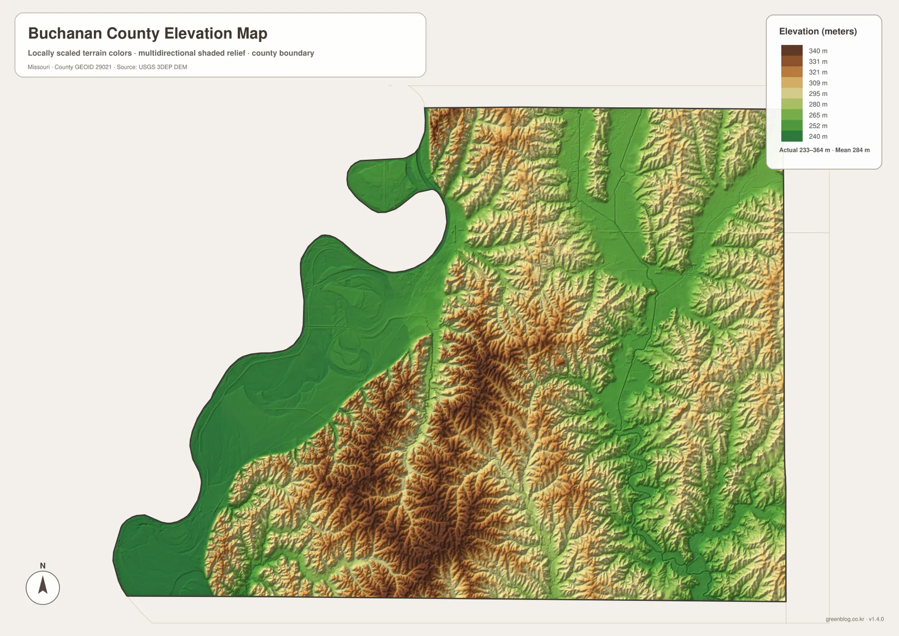
This elevation surface is intended for county-scale comparison rather than engineering or survey work. Color boundaries do not represent exact property-level elevations, and the generalized terrain should not be used for drainage design, construction staking, or other precision tasks. For exact elevation data, the USGS 3D Elevation Program or a professional survey is the appropriate source. For map reading, however, the surface is very effective at showing how the major river valleys contrast with the uplands and how smaller creeks cut into those higher areas.
Choosing the Best Map for Roads, Settlements, Water, or Relief
For a first look at Buchanan County, the general map is the most useful because it combines the county outline, St. Joseph, major highways, and smaller communities. It is the clearest option for answering questions such as where Agency lies in relation to St. Joseph, how U.S. 36 reaches the eastern side, or which routes continue toward De Kalb and Faucett. When the only goal is to compare the main settlements, the city-distribution map is cleaner because it removes much of the road detail and keeps the six emphasized communities easy to see.
For natural geography, the terrain-and-water map and elevation map work best as a pair. The water map names the Missouri River, Platte River, Hundred and Two River, Third Fork Platte River, Bee Creek, Lake Contrary, and other features. The elevation map then shows why many of those waterways occupy broad or narrow low corridors. Looking at the same area in both views is especially helpful around St. Joseph, the southwest river bends, and the eastern Platte River valley, where water and relief are closely connected.
For print or classroom use, selecting one or two maps usually communicates the subject more clearly than placing every layer on one page. The original JPG files are 3638 by 2572 pixels each, which gives more room for enlarging small labels and tributaries than the WebP versions shown in the article. The maps are suitable for general geographic reference, visual comparison, and educational use, but current road conditions, flood zones, parcel boundaries, zoning, and legally controlling boundaries should always be checked against the latest official source.
A particularly useful pairing for Buchanan County is the general map with the water map. That combination explains St. Joseph’s road concentration while also showing the Missouri River setting and the lakes southwest of the city. For the southern and eastern parts of the county, adding the city and elevation maps makes the scattered settlement pattern and the higher interior terrain easier to understand. Using only the maps needed for a specific question keeps the page readable while still preserving the county’s distinctive geography.
Frequently Asked Questions
Which map is best for comparing St. Joseph with De Kalb and Faucett?
The general county map is the best starting point because it shows St. Joseph with I-29 and U.S. 36, then follows U.S. 59, U.S. 71, Route 116, and other roads toward the southern communities. The city-distribution map is useful as a simpler companion when only the relative positions of settlements matter. For actual driving, construction, or traffic conditions, a current transportation source should be used in addition to these static maps.
Why are the Missouri River and Platte River corridors lower on the elevation map?
Both rivers occupy broad valley systems that are lower than much of the interior terrain. On the supplied elevation map, the Missouri River along the west and the Platte River along the east are shown mainly in green, while higher yellow and brown ridges fill much of the area between them. The map is designed for relative county-scale comparison, so it should not be used as a substitute for surveyed elevations at an individual property or construction site.
Can the water map be used to judge flood risk around Lake Contrary or the Missouri River?
No. The terrain-and-water map is a geographic reference for locating Lake Contrary, the Missouri River, the Platte River, named creeks, and other water features. It does not show regulatory flood zones, real-time river stages, parcel boundaries, or legal water boundaries. Flood-risk, insurance, and regulatory decisions should be based on current FEMA products and the latest information from local and state authorities.
Map File Information
The ZIP contains the original high-resolution JPG files for the county map, city-distribution map, terrain-and-water map, and elevation map shown in this article. The originals are larger than the on-page WebP images and are suitable for closer viewing and print preparation.
- Included Files: 4 maps
- File Type: JPG
Related Maps
Sources and References
- Buchanan County official overview: county background and local information from Buchanan County government.
- Buchanan County GIS Department: official county GIS mapping and data-service information.
- U.S. Census Bureau TIGER/Line Shapefiles: official geographic boundary datasets.
- USGS National Hydrography: official hydrography information for rivers, streams, and water bodies.
- USGS 3D Elevation Program: official elevation and terrain-surface data.
Green Map creates custom-edited map images using open geographic data sources such as geoBoundaries, Natural Earth, OpenStreetMap, and government open data. These maps are edited visual materials, not raw data files, and are provided for education, documents, presentations, and graphic reference.