Boone County lies in central Missouri, with Columbia at the center of a road network shaped by I-70 and U.S. 63. The Missouri River bends along much of the western and southwestern edge, while Perche Creek, Hinkson Creek, Bonne Femme Creek, and smaller streams cut through the interior. The maps on this page cover roads and communities, the main city pattern, waterways and terrain, and elevation. Matching high-resolution JPG originals for all four maps can be downloaded together in one ZIP. High-resolution map files are available for download in the section below.
Columbia is the largest place shown in the middle of the county, but the rest of Boone County spreads well beyond the city. Sturgeon, Centralia, Hallsville, and Harrisburg sit to the north, Ashland and Hartsburg are south of Columbia, and Rocheport, Huntsdale, and McBaine are close to the Missouri River side. Looking at the maps together makes it easier to connect those communities with the highways, creek valleys, and changes in elevation around them.
U.S. Census Bureau data lists about 685.55 square miles of land for Boone County in 2020. The county’s official master plan also notes that Columbia became the county seat in 1821. That long-standing central role is easy to recognize on today’s road map: I-70 crosses east to west near Columbia, U.S. 63 runs north to south, and smaller state routes branch toward communities in the northern and southern parts of the county.
Table of Contents
I-70 and U.S. 63 meet around Columbia at the center of the county
The general county map is busiest around Columbia. I-70 enters from the Rocheport side, passes north of central Columbia, and continues toward Callaway County. U.S. 63 comes down from the Hallsville direction, runs along the eastern side of Columbia, and then continues toward Ashland and the southern county line. U.S. 40 is also labeled through the Columbia area, while Route 163 provides another useful north–south reference between Columbia and Ashland.
Roads are more widely spaced in northern Boone County. Route 124 links the Harrisburg and Hallsville directions, and Routes 22 and 151 help locate Centralia and Sturgeon in the northeast. Names around the outer edge include Randolph County to the north, Callaway County to the east, Cole County to the southeast, and Howard, Cooper, and Moniteau counties along the western side. Those labels are helpful when the goal is to understand where Boone County sits within central Missouri.
The western boundary has a very different shape from the straighter northern and northeastern edges. South of Rocheport, the county line follows the broad bends of the Missouri River past the McBaine and Lupus area and toward Hartsburg. This gives the county a long, curved river edge on one side while other sections of the boundary look much more regular.
Several Columbia-area landmarks are labeled, including the Boone County Sheriff’s Office, Boone Hospital Center, and Bryan University. They are useful orientation points, but the map is not intended to replace a detailed street map or real-time navigation service. Check current Missouri Department of Transportation information when road closures, construction, or driving conditions matter.
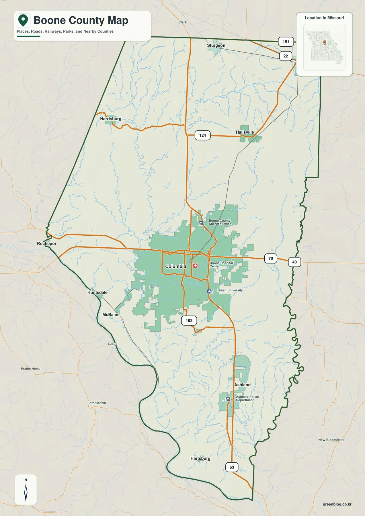
Use this map first when you are unfamiliar with Boone County. It places the largest number of roads and communities in one view, so the directions from Columbia toward Hallsville and Sturgeon, south toward Ashland and Hartsburg, or west toward Rocheport are easy to follow. It also works well as a reference after you find a creek valley or higher ridge on one of the physical maps.
A city pattern dominated by Columbia, with Ashland south and smaller cities north
The city map removes most of the road detail and gives more attention to the main population centers. Its index places Columbia first, followed by Ashland, Centralia, Hallsville, Sturgeon, and Harrisburg. The useful part is not the rank by itself but the layout: one large central city, a notable city to the south, and several smaller cities spread across the northern half of the county.
Ashland sits south of Columbia near U.S. 63, making the relationship between the two cities easy to see. Hartsburg is farther south near the Missouri River, but it is not part of the six-city index on this map. That distinction is a reminder that the city map emphasizes the leading places in its index, while the general map is better for finding a wider range of smaller communities.
Northern Boone County does not form a single line of towns. Centralia is close to the northeastern edge, Sturgeon lies farther west, Hallsville is nearer Columbia, and Harrisburg is separated to the northwest. Route 124 helps connect the Harrisburg–Hallsville area, while Routes 22 and 151 are useful road references around Centralia and Sturgeon.
The neighboring county labels also help explain why communities on opposite sides of Boone County face different regional directions. Centralia is close to the Callaway and Audrain County side, while Rocheport sits beside the river boundary toward Howard and Cooper counties. Two places within Boone County can therefore be much closer to different neighboring counties than to each other.
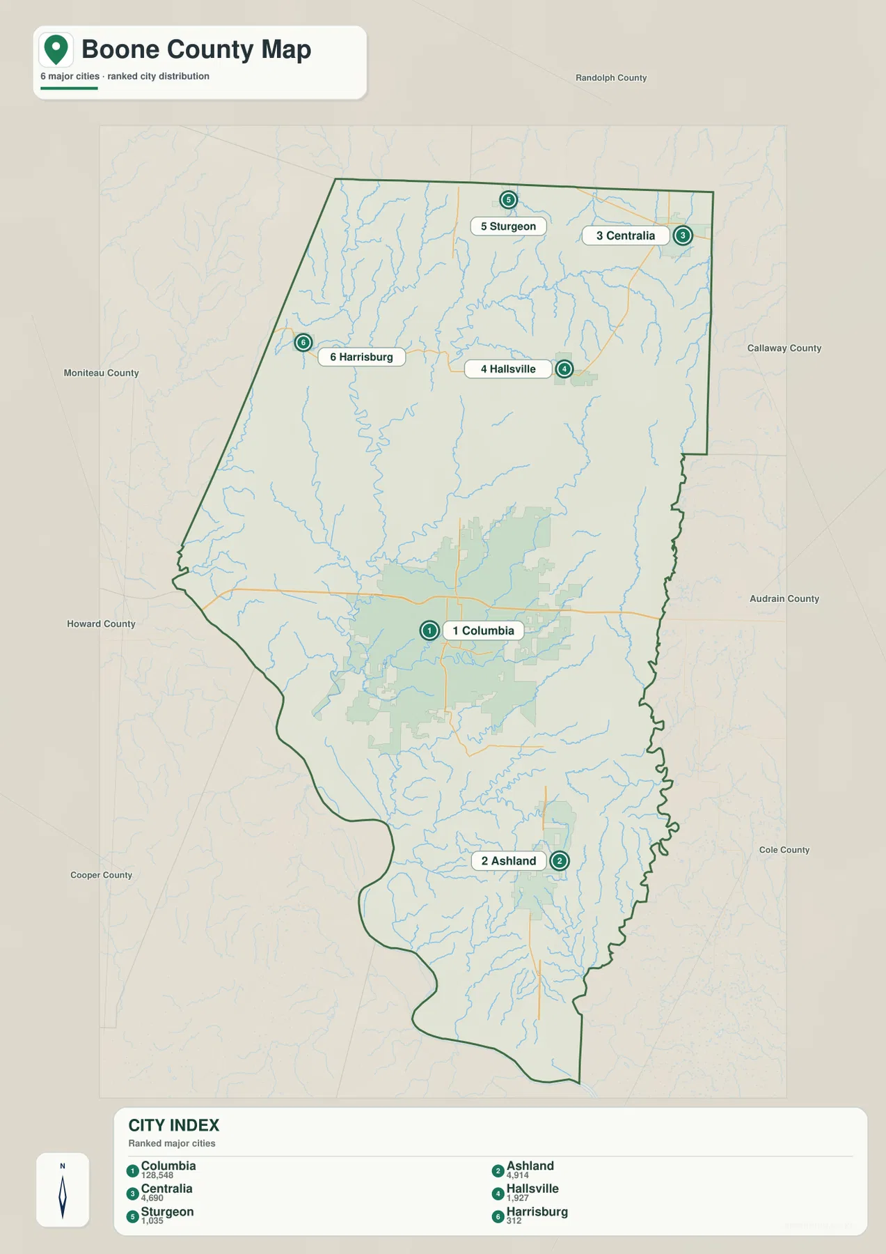
Treat the city index as a map reference rather than a permanent population table. Population estimates change over time, so exact figures should be checked with the U.S. Census Bureau or an official municipal source. The map is most useful for seeing where the major listed cities sit relative to Columbia and to one another.
Missouri River lowlands and the Perche, Hinkson, and Bonne Femme creek valleys
The water-and-terrain map shifts attention from highways to rivers, creeks, lakes, and the shape of the land. The Missouri River is the largest feature and follows the western and southwestern boundary in broad bends. Perche Creek runs through the western interior toward the river, Hinkson Creek passes through the Columbia area and continues southeast, and Bonne Femme Creek drains the southern part of the county toward the Missouri River.
Smaller named waters add a surprising amount of detail. Hulen Lake, Moores Lake, Stephens Lake, and Lake Cyrene appear around central Boone County, with Bass Lake farther southeast. Silver Fork and Tri-City Lake are shown in the north, while Cedar Creek and Little Cedar Creek occupy the eastern side. Together they show that Boone County is crossed by many smaller waterways, not just the Missouri River.
Columbia itself is not sitting on a completely flat plain. Small stream valleys cut through and around the city, and low ridges separate many of those channels. South of Columbia, the Bonne Femme area becomes more deeply cut by narrow valleys, while broader low ground appears closer to the Missouri River. Comparing Route 163 and U.S. 63 on the road map with this terrain view helps explain why local roads bend or cross valleys rather than following perfectly straight lines.
The 2025 Boone County Master Plan appendix identifies places such as Eagle Bluffs Conservation Area, Rock Bridge Memorial State Park, and Finger Lakes State Park, and it notes the Katy Trail along the southwestern part of the county. Those places add useful local context to the river corridor, southern valleys, and northern water features. This map, however, is not a flood-zone map, parcel map, legal water-boundary map, or navigation chart.
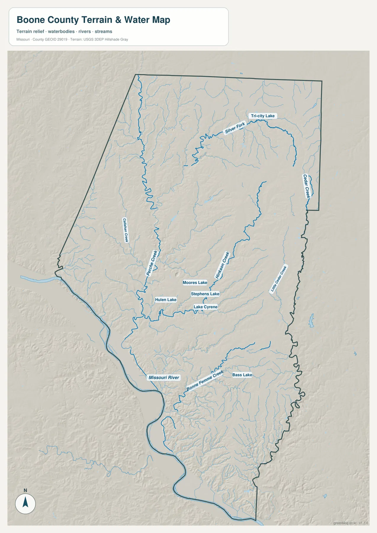
Use this map to locate named waterways and to see the general direction of creek valleys. It should not be used to decide whether a property floods, whether a channel is navigable, or where a legal water boundary lies. Small streams can also be represented differently at another map scale. For regulated flood information or legal limits, rely on current federal, state, and local sources.
From roughly 144-meter river bottoms to high ground near 290 meters
The elevation map uses color to show the county’s broad changes in height. Its legend spans roughly 144 to 290 meters, with a mean near 236 meters. The lowest green terrain follows the Missouri River along the western and southwestern edge and also reaches inland along major creek valleys. Yellow and brown shades are more common across higher ground in the north and east.
Columbia occupies a middle setting rather than one of the county’s lowest or highest areas. Lower stream corridors pass west and south of the developed area, while the ground rises again toward the east. Ashland and the southern interior are also uneven, with narrow valleys alternating with ridges and lower colors stretching toward the Missouri River along tributaries.
The northern part of the county is generally higher, but it is not one continuous upland. Lower colors follow Silver Fork, Cedar Creek, and other stream valleys through the higher terrain around Sturgeon, Centralia, and Hallsville. The eastern side shows the same repeated pattern of ridges and valleys, which matches the waterways named on the terrain map.
Rocheport, McBaine, and the Hartsburg direction are useful references for the low Missouri River corridor. Green terrain stays close to the river through these areas, then gives way to higher ground a short distance inland. Looking back and forth between the water map and the elevation map makes that relationship very clear.
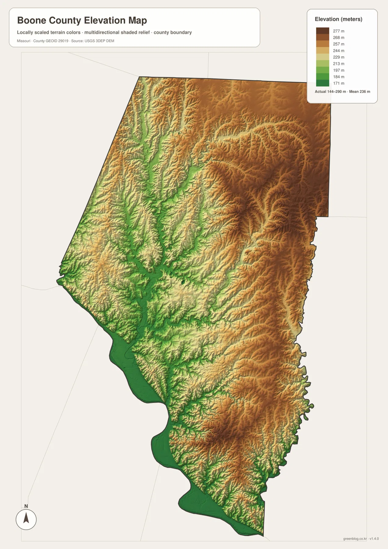
This map is meant for county-scale relief, not exact site elevation. A color boundary does not give survey-grade height for a property or building and should not be used for engineering design or drainage calculations. Exact point elevations should be checked with USGS elevation data or a professional survey. For broader questions about river bottoms, creek valleys, and upland ridges, the map is a useful visual reference.
Choosing the right Boone County map for the task
Start with the general county map for roads, boundaries, and community locations. It is the strongest single view for Columbia, I-70, U.S. 63, Routes 124 and 163, the Missouri River edge, and a wide range of named places. Switch to the city map when you want a cleaner comparison of Columbia, Ashland, Centralia, Hallsville, Sturgeon, and Harrisburg.
For rivers and landform, use the water-and-terrain map together with the elevation map. The Missouri River lowland appears in both, and lower strips along Perche, Hinkson, and Bonne Femme creeks match the named drainage lines. Higher northern and eastern ridges stand out more clearly on the elevation map, while the terrain map makes the streams and lakes easier to identify.
For a classroom sheet or printed reference, choose only the maps that fit the topic. The general and city maps work well for roads and settlements, while the water-and-terrain and elevation maps are better for rivers, valleys, and relief. Each original JPG is 2572 × 3638 pixels, larger than the WebP image shown on the page, so labels and smaller water features are easier to inspect when zoomed. Always use current official sources for road conditions, flood zones, parcel lines, and legal boundaries.
Frequently Asked Questions
Which map is best for comparing Columbia and Ashland with the main highways?
Use the general county map when you want Columbia, Ashland, I-70, U.S. 63, and Route 163 in the same view. Ashland is south of Columbia near U.S. 63, and Route 163 gives another useful north–south reference. The city map can simplify the comparison, but current driving routes and road conditions should always be checked with up-to-date transportation information.
Why is the Missouri River side of Boone County so low on the elevation map?
The Missouri River occupies a broad valley along the western and southwestern county boundary, so that corridor appears in the lowest green elevation colors. Tributaries such as Perche Creek and Bonne Femme Creek descend toward the same low area and form narrower valleys farther inland. The map’s roughly 144 to 290 meter range is intended for county-scale relief, not exact survey elevations for individual properties.
Can the water map be used to determine flood risk around Stephens Lake or the Missouri River?
No. The water-and-terrain map shows where Stephens Lake, Tri-City Lake, the Missouri River, and major creeks are located relative to the surrounding terrain. It does not show regulated flood zones, predicted flood depths, parcel lines, or legal water limits. Use current FEMA and local government information for flood-risk decisions.
Map File Information
The original high-resolution JPG files for the county map, city map, water-and-terrain map, and elevation map are bundled in one ZIP. They are larger than the WebP versions shown on the page and work well for closer inspection or print layouts.
- Included Files: 4 maps
- File Type: JPG
Related Maps
Sources and references
- U.S. Census Bureau QuickFacts – Boone County, Missouri: official county land-area and demographic reference data.
- Boone County Master Plan 2025: official county planning material covering natural resources, parks, and conservation context.
- U.S. Census Bureau TIGER/Line Shapefiles: official reference data for county and administrative boundaries.
- USGS National Hydrography: official reference for rivers, streams, lakes, and other hydrographic features.
- USGS 3D Elevation Program: official elevation and terrain data reference.
Green Map creates custom-edited map images using open geographic data sources such as geoBoundaries, Natural Earth, OpenStreetMap, and government open data. These maps are edited visual materials, not raw data files, and are provided for education, documents, presentations, and graphic reference.