Washtenaw County combines the dense Ann Arbor–Ypsilanti urban area with lake-filled uplands around Dexter and Chelsea, lower ground toward the east, and smaller communities such as Saline, Milan, and Manchester to the south. I-94, US-23, and M-14 provide the clearest transportation framework, while the Huron River ties much of the eastern half together. The contrast becomes even stronger when the water and elevation maps are viewed beside the road map. High-resolution map files are available for download in the section below.
This page explains the general county map, ranked city index, water map, and elevation map using the place names and terrain visible in the supplied files. High-resolution A3 JPG originals for all four maps are available together in one ZIP, making the set useful for printing, classroom work, trip preparation, and side-by-side geographic comparison.
Table of Contents
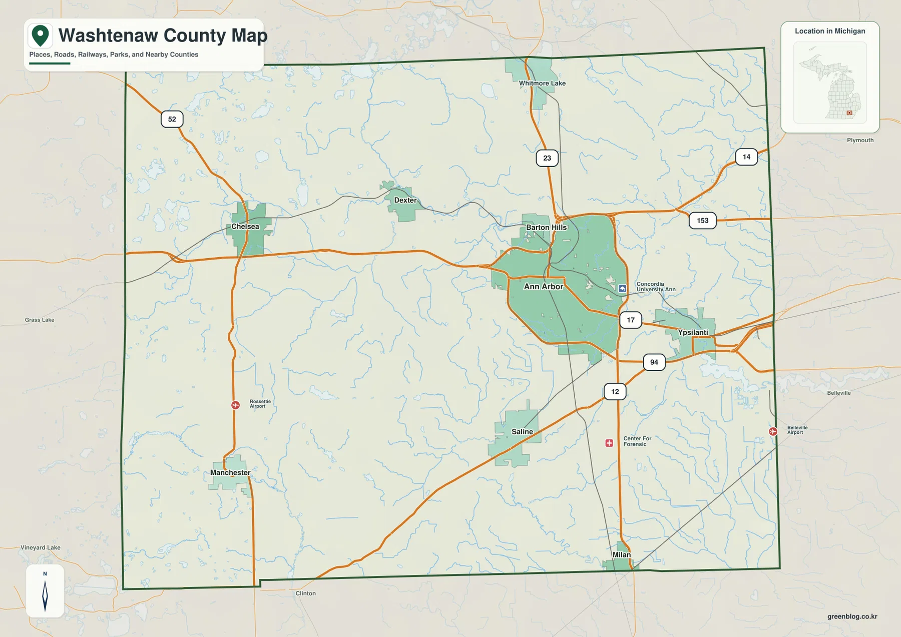
Ann Arbor and Ypsilanti at the center of the major road network
Ann Arbor is the dominant settlement on the general county map, with Ypsilanti immediately to the east. I-94 runs south of Ann Arbor and continues toward Ypsilanti, while US-23 descends from the Whitmore Lake side of the county, passes east of Ann Arbor, and continues south. The proximity of these two highways creates the clearest transportation hub in the county.
M-14 curves around the northern side of Ann Arbor and connects with the major roads east and west of the city. M-153 appears near the eastern edge, M-17 connects the Ann Arbor–Ypsilanti corridor, and US-12 crosses the southern part of the urban area before continuing west. Farther west, M-52 passes through Chelsea and continues south toward Manchester.
Dexter lies northwest of Ann Arbor, while Chelsea is farther west. Saline is south of Ann Arbor, and Milan is close to the southeastern county boundary. Whitmore Lake appears near the northern edge and Manchester in the southwest. Those locations make it clear that Washtenaw County is not arranged along one straight urban strip even though Ann Arbor and Ypsilanti form its strongest city pair.
The map also includes rail lines, airport symbols, park areas, and selected institutional labels such as Concordia University Ann Arbor. It is intended for county-scale orientation rather than live traffic or turn-by-turn navigation. Its main value is showing how the principal roads connect the large eastern city area with the smaller communities to the west and south.
A six-city index dominated by Ann Arbor
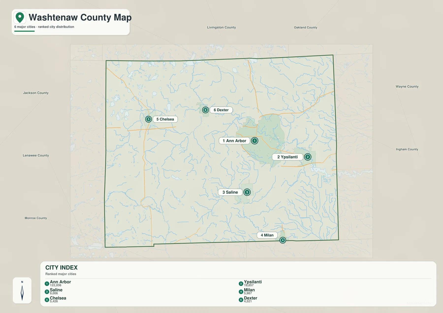
The city index ranks six selected communities. Ann Arbor is number 1 with a printed value of 122,036, followed by Ypsilanti at 19,857, Saline at 9,006, Milan at 5,987, Chelsea at 5,426, and Dexter at 4,521. These are the values printed in the supplied city-index graphic and are not presented here as newly calculated population estimates.
The distribution shows a strong eastern concentration around Ann Arbor and Ypsilanti, with smaller centers spread in other directions. Saline lies to the south, Milan farther southeast, Chelsea to the west, and Dexter northwest of Ann Arbor. The index therefore makes both the size difference and the geographic spread of the selected cities easy to compare.
There are no connector lines or mileage labels on this city map. It is a ranking and location graphic rather than a distance chart. Use it to compare the relative positions of the six selected cities, then refer to the general county map or a current routing service when actual driving mileage or travel time is needed.
The Huron River, Ford Lake, and the lake country west of Ann Arbor
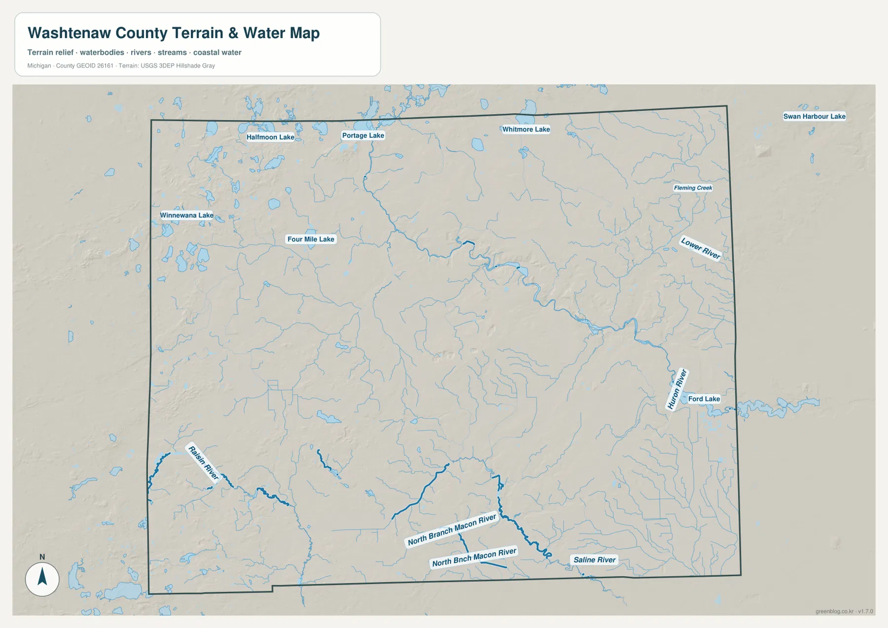
The Huron River is the most prominent waterway on the map. It bends through the north-central and eastern parts of the county, reaches the Ann Arbor area, and continues toward Ypsilanti and Ford Lake. Numerous smaller streams join the river, especially across the eastern half, making the Huron corridor an important reference for understanding both the urban area and the surrounding lowlands.
The western and northwestern parts of the county have a different water pattern. Portage Lake, Halfmoon Lake, Four Mile Lake, and many smaller lakes are scattered north of Dexter and Chelsea, while Whitmore Lake sits near the northern boundary. This concentration of lakes gives the western uplands a noticeably different appearance from the more continuous Huron River corridor around Ann Arbor and Ypsilanti.
The southern side contains the Saline River and the North Branch Macon River, while the River Raisin system appears in the southwest. Fleming Creek is labeled in the northeast and flows toward the Huron River. Together these waterways show that the county drains in several directions rather than through a single uninterrupted river system.
Washtenaw County Parks and Recreation maintains parks, preserves, and trails throughout the county and has led the multi-agency Border-to-Border Trail effort since the late 1990s. The county’s official recreation pages also highlight nature preserves and parks associated with river, lake, wetland, and rolling upland settings. Those resources provide local context for the water and terrain visible on the maps.
Use the water map for names, relative positions, and broad drainage relationships. It does not show flood probability, legal shoreline boundaries, navigable depth, parcel ownership, or current water conditions. Those questions require current products from the responsible public agency.
A 190–369 meter elevation range from eastern lowlands to western uplands
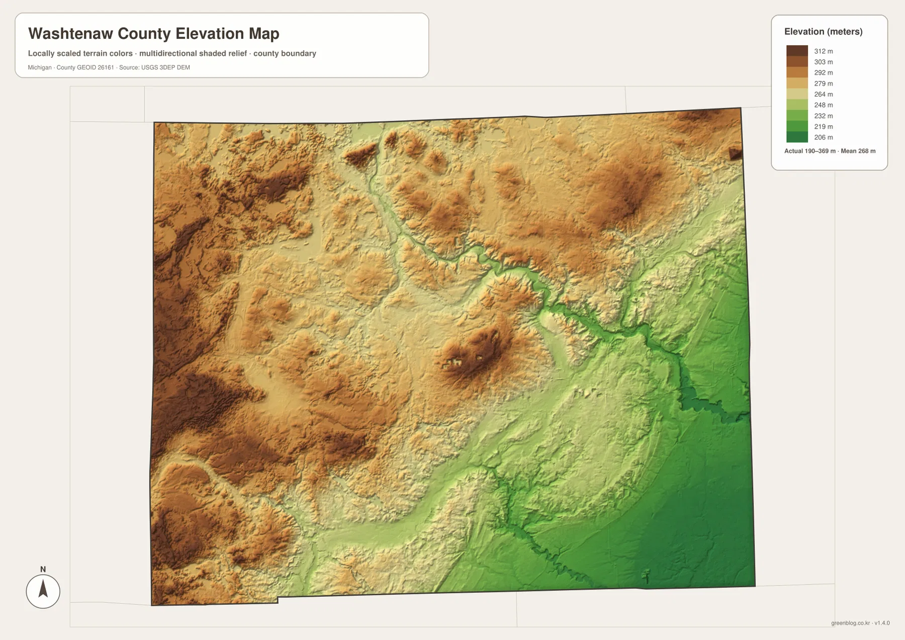
The elevation map reports an actual range of about 190 to 369 meters and a mean near 268 meters. The lowest greens dominate the eastern and southeastern side of the county, especially along the Huron River as it approaches Ypsilanti and Ford Lake. The western and northwestern portions shift through tan into dark brown and contain much of the county’s highest ground.
The uplands west of Chelsea and across the northwest are especially prominent. High ridges and rounded hills are interrupted by narrow lower valleys and lake basins, producing a much rougher surface than the broad eastern lowlands. The Dexter lake country sits within this varied terrain, which helps explain why the water map and the elevation map show so many small basins in the same area.
The Huron River valley forms a visible lower corridor through the central part of the county toward Ann Arbor. A separate cluster of higher terrain appears southwest of Ann Arbor, while the land toward Saline and Milan becomes lower and smoother again. With nearly 180 meters between the mapped low and high points, the county has substantial local relief even though it is not mountainous.
This elevation layer is intended for broad county-scale comparison. It should not be used as survey-grade data for a building site, drainage project, road design, or other work where small elevation differences matter. More detailed USGS products and field measurements are appropriate for precise technical decisions.
How Ann Arbor, Dexter, and Ypsilanti reveal three different settings
Ann Arbor brings the road, river, and relief layers together in one place. I-94, US-23, and M-14 form a dense transportation framework, the Huron River crosses the city area, and the elevation map shows the river occupying lower ground between nearby hills. That combination makes Ann Arbor an effective reference point for understanding the eastern half of the county.
Dexter and Chelsea represent a more lake-rich western setting. Major roads become less dominant, smaller communities are separated by broader rural areas, and Portage Lake, Halfmoon Lake, and numerous other basins appear nearby. Elevation also rises toward the west, creating rolling uplands that contrast sharply with the lower terrain around Ypsilanti.
Ypsilanti and Milan occupy the lower eastern and southeastern side. The Huron River and Ford Lake shape the Ypsilanti area, while the land toward Milan is generally smoother and lower than the western uplands. Saline sits between these settings, close to US-12 and a separate river system south of Ann Arbor.
The set works well for general county orientation, school assignments, local-history presentations, and trip preparation. It does not replace parcel records, zoning documents, flood-regulation products, legal surveys, or real-time transportation information, so specialized decisions should rely on current county, state, or federal sources.
Frequently Asked Questions
Which map best shows the relationship between Ann Arbor and Ypsilanti?
The general county map is the quickest way to compare the two cities with I-94 and US-23. The water map adds the Huron River and Ford Lake, which helps explain how the same urban corridor relates to the county’s main eastern waterway.
Are the city-index values current population estimates?
The values described on this page are the numbers printed in the supplied city-index graphic. For the latest population figures, use current U.S. Census Bureau or Washtenaw County statistics rather than treating the map values as a new estimate.
Can the 190–369 meter elevation range be used for engineering or surveying?
No. The elevation map is suitable for broad comparison of higher and lower terrain, but precise construction, drainage, engineering, or survey work requires more detailed official elevation data and field verification.
Map File Information
A ZIP containing the high-resolution A3 JPG originals for the Washtenaw County map, city index, water map, and elevation map.
- Included Files: county map, city index map, water map, elevation map
- File Type: JPG
Related Maps
Sources and references
- U.S. Census Bureau TIGER/Line Shapefiles – official geographic files for county boundaries, roads, and place references.
- USGS National Hydrography – federal source for rivers, streams, lakes, and other hydrographic features.
- USGS 3D Elevation Program – official U.S. elevation and terrain data resources.
- Washtenaw County official website – county government, local information, maps, and resident services.
- Washtenaw County Parks, Preserves, Trails – official information about parks, nature preserves, and the Border-to-Border Trail.
Green Map creates custom-edited map images using open geographic data sources such as geoBoundaries, Natural Earth, OpenStreetMap, and government open data. These maps are edited visual materials, not raw data files, and are provided for education, documents, presentations, and graphic reference.