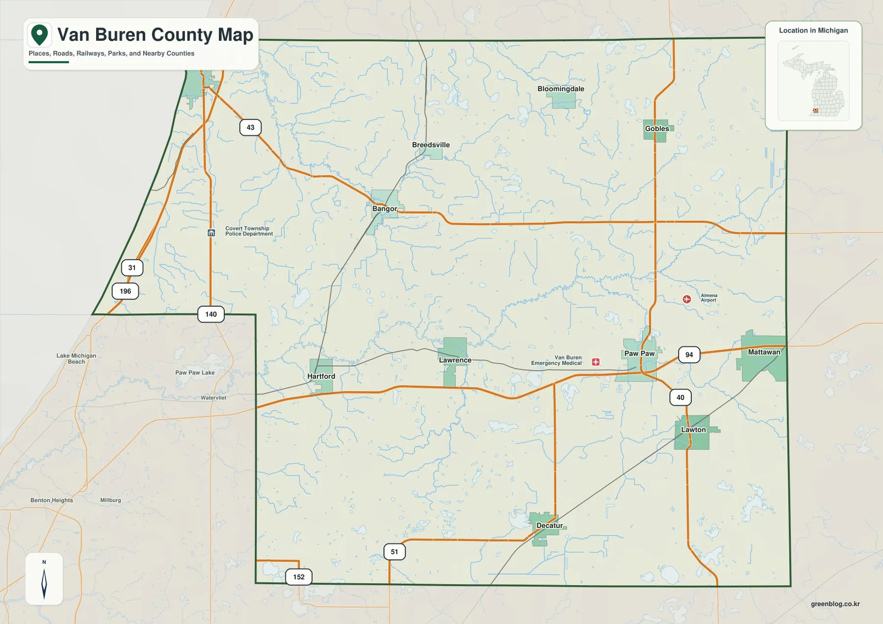
Van Buren County stretches across southwestern Michigan from the Lake Michigan shore at South Haven to the inland communities of Paw Paw, Mattawan, Lawton, and Decatur. The western edge is low and strongly influenced by the lake, while the center and east contain the Paw Paw River system, many small lakes, and more rolling terrain. I-94 and M-43 make the contrast especially easy to follow because they connect the shoreline side of the county with its inland towns. High-resolution map files are available for download in the section below.
This page explains the main roads and settlements, the ranked city distribution, the rivers and lakes, and an elevation range of roughly 177 to 321 meters. High-resolution A3 JPG originals for all four maps can be downloaded together in one ZIP for printing, classroom use, trip preparation, or side-by-side geographic comparison.
Table of Contents
From the Lake Michigan shore to the I-94 corridor
South Haven occupies the county’s northwestern shoreline and provides the clearest starting point for reading the road network. I-196 and the US-31 corridor run along the western side, while M-43 leaves the South Haven area and heads inland through the Bangor side of the county. That route visually connects the lakefront city with a much broader rural interior.
Farther south and east, Hartford and Lawrence sit between the shoreline side and the county’s eastern population centers. Paw Paw lies directly along I-94, with Mattawan farther east toward Kalamazoo County. M-40 runs south from Paw Paw through the Lawton area, while M-51 appears near Decatur and M-152 runs close to the southern county line.
The northern interior includes Bloomingdale, Gobles, Breedsville, and Bangor, with smaller roads and waterways filling the spaces between them. The county boundary itself is irregular on the west: the Lake Michigan side slopes diagonally, and the southwestern portion steps inward before the southern boundary continues east. The shape is easier to understand on the full county map than from a list of compass directions.
Paw Paw also serves as the center of county government activity. Van Buren County’s official website lists its administration and many county departments at Paw Paw addresses, matching the settlement’s prominent inland position near I-94 and M-40.
Six ranked communities spread from the shoreline to the eastern interior
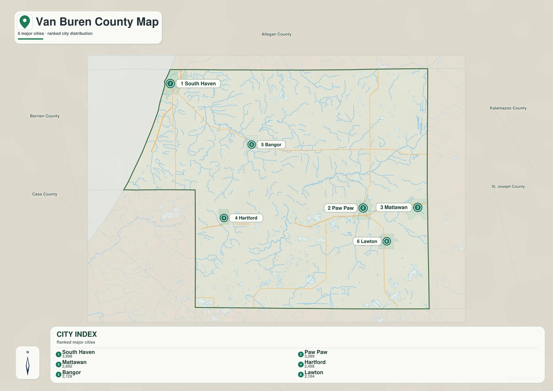
The city index ranks six selected communities. South Haven is number 1 with a printed value of 3,998, followed by Paw Paw at 3,289, Mattawan at 2,692, Hartford at 2,458, Bangor at 2,129, and Lawton at 2,104. These are the values printed in the city index itself and should not be treated as newly calculated population estimates.
Their positions show a county with several separate local centers. South Haven is on the Lake Michigan side, Bangor is inland to the east, and Hartford occupies the southwestern interior. Paw Paw and Mattawan form an eastern pair close to the I-94 corridor, while Lawton lies south of Paw Paw. The ranked locations therefore reveal a much wider east–west spread than a single urban cluster would suggest.
There are no connector lines or mileage labels on the city index. It is a ranking and location graphic, not a distance chart. Use it to compare where the selected communities sit within the county, then refer to the general road map or a current routing service when actual driving mileage is needed.
The Paw Paw River system and the Black River side of the county
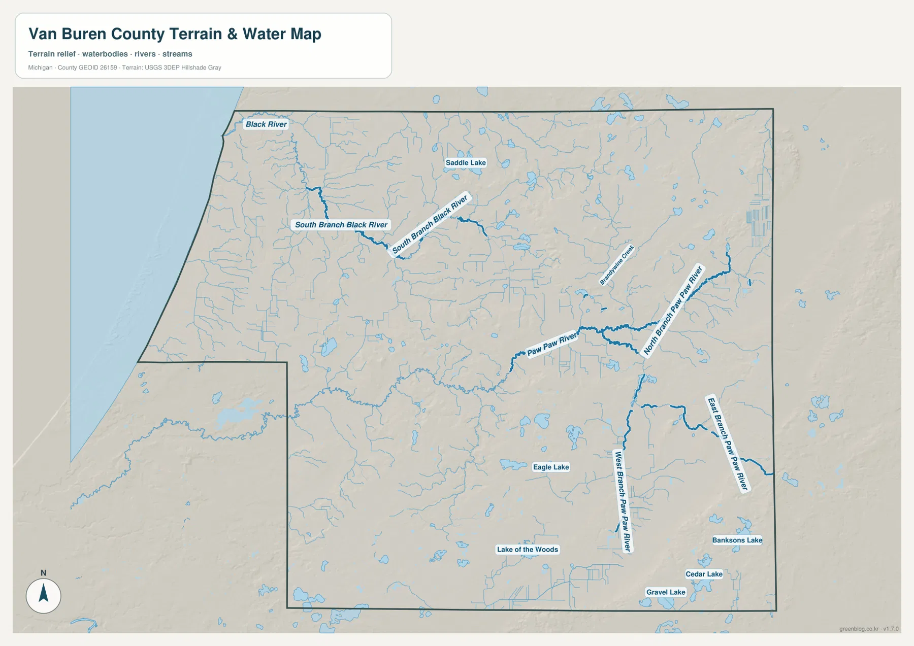
The Paw Paw River is one of the strongest water features in the county’s interior. Its main channel crosses the central and eastern area, while the North Branch Paw Paw River and East Branch Paw Paw River approach from the east and southeast. The West Branch Paw Paw River extends northward from the southern interior, giving the Paw Paw area a clear network of connected river valleys.
A different drainage pattern appears in the northwest. Black River and South Branch Black River occupy the South Haven side and head toward Lake Michigan rather than following the Paw Paw River system. This division helps explain why the western shoreline and the central-eastern interior have distinct water settings even though they belong to the same county.
Named lakes are scattered across the map. Saddle Lake appears in the north-central area, Eagle Lake lies farther south, and Lake of the Woods sits in the southern interior. Bankson Lake, Cedar Lake, and Gravel Lake are grouped closer to the southeastern side. Numerous smaller unnamed lakes and ponds fill the spaces around these larger labels, especially east of Paw Paw and south of Lawton.
Lake Michigan adds a much larger water feature to the county’s western edge. Michigan DNR’s Van Buren State Park, south of South Haven, has about a mile of sandy shoreline, dunes, and wooded trails. The park also connects to a paved spur leading toward South Haven and the longer Van Buren Trail, providing a practical example of how the county’s lakefront landscape differs from its inland river and lake country.
Use the water map for names, relative positions, and broad drainage relationships. It is not a flood-risk, navigation, parcel, or legal-boundary product, and it does not provide current water depth or property information. Those questions require current agency data designed for the specific decision.
Elevation rises from the western lowlands toward the east and southeast
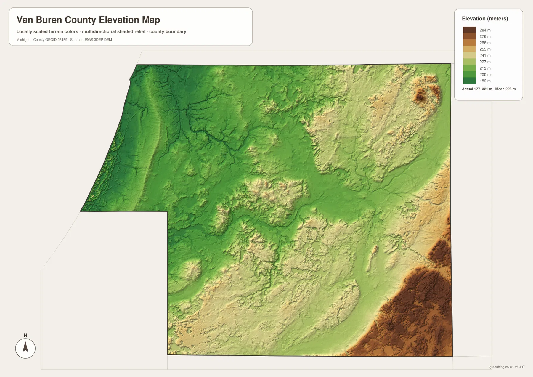
The elevation map reports an actual range of about 177 to 321 meters and a mean near 226 meters. The lowest greens dominate the Lake Michigan side, where the western county is broad and comparatively low. Elevation generally increases inland, and river valleys remain visible as lower corridors cutting through the higher ground.
Central Van Buren County mixes low flats with scattered rolling uplands. The Paw Paw River corridor across the eastern-middle section remains relatively gentle, but higher terrain becomes much more common toward the northeast. Small knobs and ridges appear there in tan and brown, creating a rougher surface than the low shoreline side.
The strongest high ground appears near the southeastern edge. Dark brown relief south and southeast of Lawton reaches the upper end of the county’s mapped elevation range, with other elevated patches along the eastern boundary. From the low Lake Michigan side to these inland hills, the total difference is roughly 144 meters.
That amount of relief is modest compared with mountainous regions, yet it is enough to shape the look of local streams and lake basins. The Paw Paw River branches occupy lower corridors, while many small lakes are set among rolling eastern and southern terrain. The elevation surface is intended for county-scale comparison, not survey, construction, drainage, or engineering work that requires precise site measurements.
Why South Haven, Paw Paw, and Lawton feel like different parts of the same county
South Haven is defined first by Lake Michigan, the I-196 and US-31 corridor, and the Black River side of the drainage network. It is also among the lowest parts of the county on the elevation map. Moving inland along M-43 toward Bangor replaces the open lakeshore setting with smaller lakes, rural roads, and a more gently rolling interior.
Paw Paw presents a different combination. I-94 and M-40 create a major road junction, several branches of the Paw Paw River cross the surrounding area, and higher terrain begins to appear farther east. Mattawan is positioned even closer to the Kalamazoo County side of the I-94 corridor, while the countryside south of Paw Paw contains an especially dense mix of small lakes.
Lawton and the southeastern corner show the county’s highest relief. The road network is less dominated by the lake shore, and the landscape includes several named lakes beneath noticeably higher surrounding ground. Hartford and Decatur occupy an intermediate setting between those eastern hills and the lower western side, which helps explain why Van Buren County changes character so much over a relatively short distance.
These maps are useful for general county orientation, school work, local-history presentations, and trip preparation. They do not replace parcel records, zoning documents, flood-regulation products, legal surveys, or real-time road information, so specialized decisions should rely on current county, state, or federal sources.
Frequently Asked Questions
Why does the landscape change so much between South Haven and Paw Paw?
South Haven is on the low Lake Michigan side of the county, while Paw Paw sits inland near I-94 and the Paw Paw River system. Elevation rises toward the east, and the interior contains many more small lakes and rolling uplands, so the road, water, and relief maps show noticeably different settings.
Are the numbers in the city index current population estimates?
The values described here are the numbers printed in the city-index map. For the latest population figures, use current U.S. Census Bureau or local-government statistics rather than treating the map values as a new estimate.
Can the 177–321 meter elevation range be used for construction or surveying?
No. The elevation layer is suitable for broad comparison of higher and lower terrain, but precise construction, drainage, engineering, or survey work requires more detailed official elevation data and field verification.
Map File Information
A ZIP containing the high-resolution A3 JPG originals for the Van Buren County map, city index, water map, and elevation map.
- Included Files: county map, city index map, water map, elevation map
- File Type: JPG
Related Maps
Sources and references
- U.S. Census Bureau TIGER/Line Shapefiles – official geographic files for county boundaries, roads, and place references.
- USGS National Hydrography – federal source for rivers, streams, lakes, and other hydrographic features.
- USGS 3D Elevation Program – official U.S. elevation and terrain data resources.
- Van Buren County official website – county government, local information, visitor resources, and official contacts in Paw Paw.
- Michigan DNR – Van Buren State Park – official information about the Lake Michigan shoreline, beach, trails, and park access south of South Haven.
Green Map creates custom-edited map images using open geographic data sources such as geoBoundaries, Natural Earth, OpenStreetMap, and government open data. These maps are edited visual materials, not raw data files, and are provided for education, documents, presentations, and graphic reference.