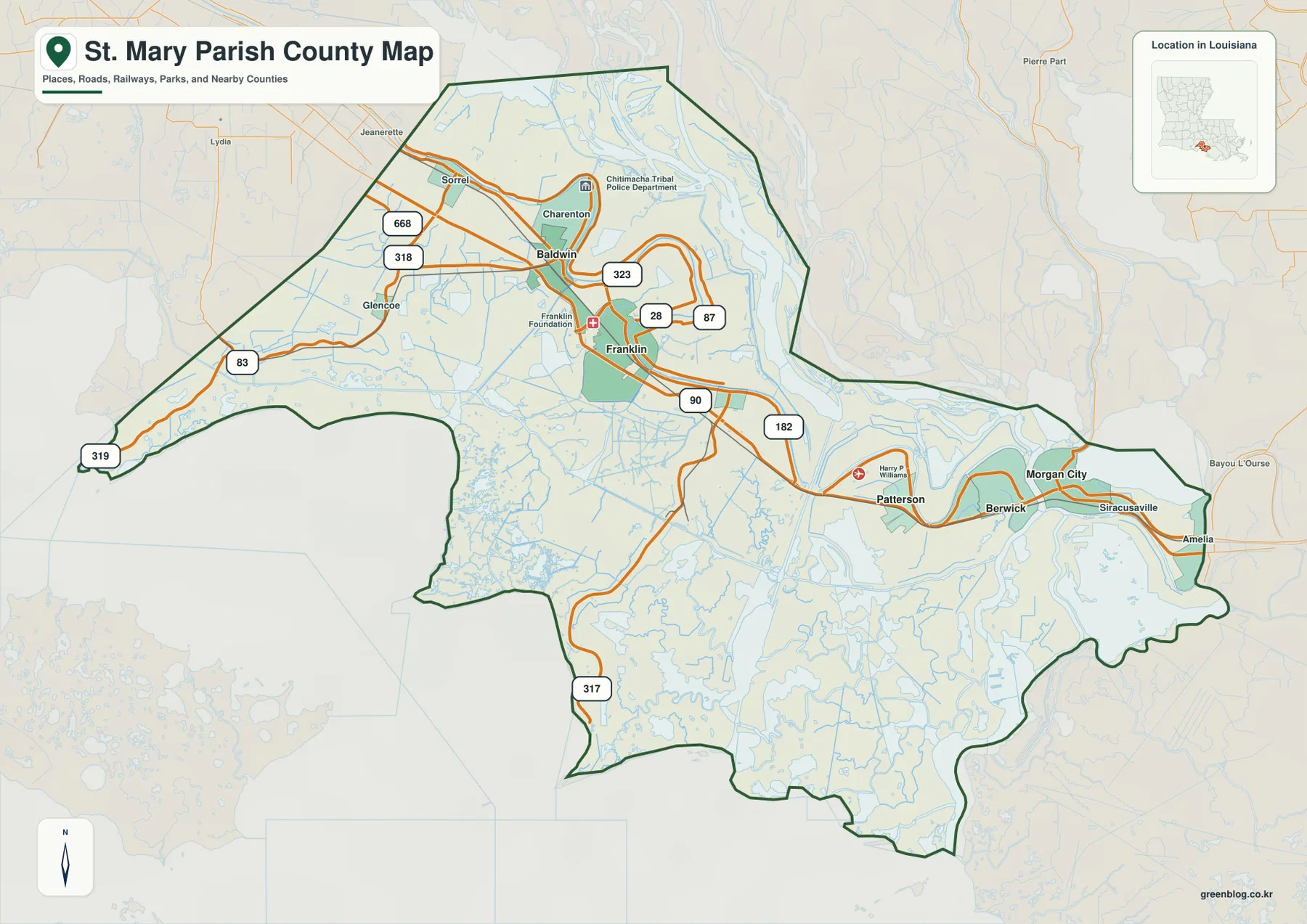
St. Mary Parish in southern Louisiana has two very different geographic faces. Franklin, Baldwin, Patterson, Berwick, and Morgan City form a long inhabited corridor along U.S. 90, while the land to the south opens into an extensive maze of marshes, bayous, coastal bays, and Gulf-facing wetlands. The contrast is visible immediately when the road map is compared with the terrain-and-water map. This page explains those settlement, highway, and coastal-water relationships, and the matching high-resolution JPG map files can be downloaded together in a ZIP.
Franklin is the parish seat. Louisiana’s official St. Mary Parish profile identifies Franklin as the seat, and St. Mary Parish Government operates from the courthouse in Franklin. The parish government’s history page notes that St. Mary was created in 1811 and highlights the early importance of communities such as Franklin, Baldwin, and Patterson. On the supplied map, starting at Franklin and following U.S. 90 east toward Morgan City or west toward Baldwin gives the clearest first view of the parish before attention shifts south into the wetlands.
Table of Contents
Franklin sits where the U.S. 90 corridor meets the Bayou Teche settlement belt
The general map places Franklin near the north-central part of the parish, with U.S. 90 running just south of the main developed area. LA 28, LA 87, and LA 323 are visible around Franklin, while LA 318 and LA 668 help connect the Baldwin side. The road pattern can look complicated at first, but U.S. 90 and Franklin provide a simple fixed reference from which the smaller state routes make sense.
Baldwin and Charenton sit northwest of Franklin, with Sorrel and Glencoe farther west. A Chitimacha Tribal Police Department label appears near Charenton, giving the western interior another recognizable landmark. The settlement pattern is not concentrated in a single metropolitan center; instead, towns and communities stretch along the Bayou Teche and highway corridor across much of the northern parish.
Patterson, Berwick, and Morgan City form the densest eastern urban cluster
Following U.S. 90 east from Franklin brings the map to Patterson and then the closely spaced Berwick–Morgan City area. Patterson is marked near Harry P. Williams Memorial Airport, while Berwick and Morgan City occupy opposite sides of major waterways and appear visually as one dense eastern cluster. Streets, roads, and water crossings are much more concentrated here than in the western half of the parish.
U.S. 90 continues through the eastern side toward Amelia, and LA 182 provides another useful reference around Patterson and Morgan City. Siracusaville appears east of Morgan City, with Amelia near the parish boundary. Rather than treating these names as isolated points, it is more helpful to see the area as a continuous U.S. 90 urban corridor interrupted and shaped by large channels and low-lying water.
The western extension and LA 317 lead away from the town corridor into open marsh
The western edge of St. Mary Parish has a very different road pattern from the Franklin–Morgan City corridor. LA 83 extends far west, and LA 319 appears close to the outer coastal side. Large town labels disappear quickly, leaving local roads and water features to define most of the landscape. This long western extension is one reason the parish looks much larger than its populated corridor suggests.
Farther south, LA 317 reaches deep into the wetland interior. The density of roads falls sharply as it moves away from the northern towns, while channels and marsh features become more numerous. LA 317 is therefore a useful visual clue for understanding how St. Mary Parish extends from settled sugar-country communities into the Gulf-facing coastal plain.
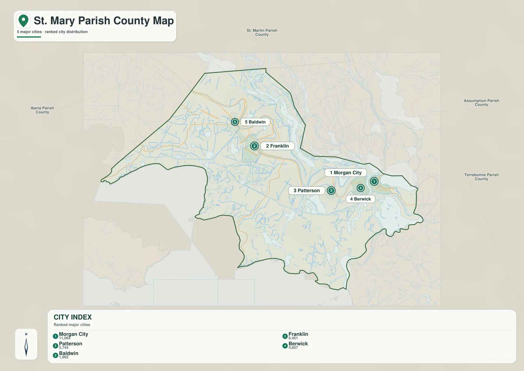
The ranked city index separates five major places into western and eastern groups
The city-index graphic ranks Morgan City number 1, Franklin 2, Patterson 3, Berwick 4, and Baldwin 5. These numbers are rankings, not straight-line or driving distances. Their positions are more informative than the numbers themselves: Morgan City, Berwick, and Patterson form a tight eastern group, while Franklin and Baldwin sit farther west along the long northern settlement corridor.
Charenton, Amelia, Siracusaville, and other labels visible on the general map are not part of the five-place index. The city view should therefore be used as a simplified comparison of the selected major communities rather than a complete list of settlements. It is especially useful for seeing the gap between the Franklin–Baldwin side and the Morgan City–Patterson–Berwick cluster.
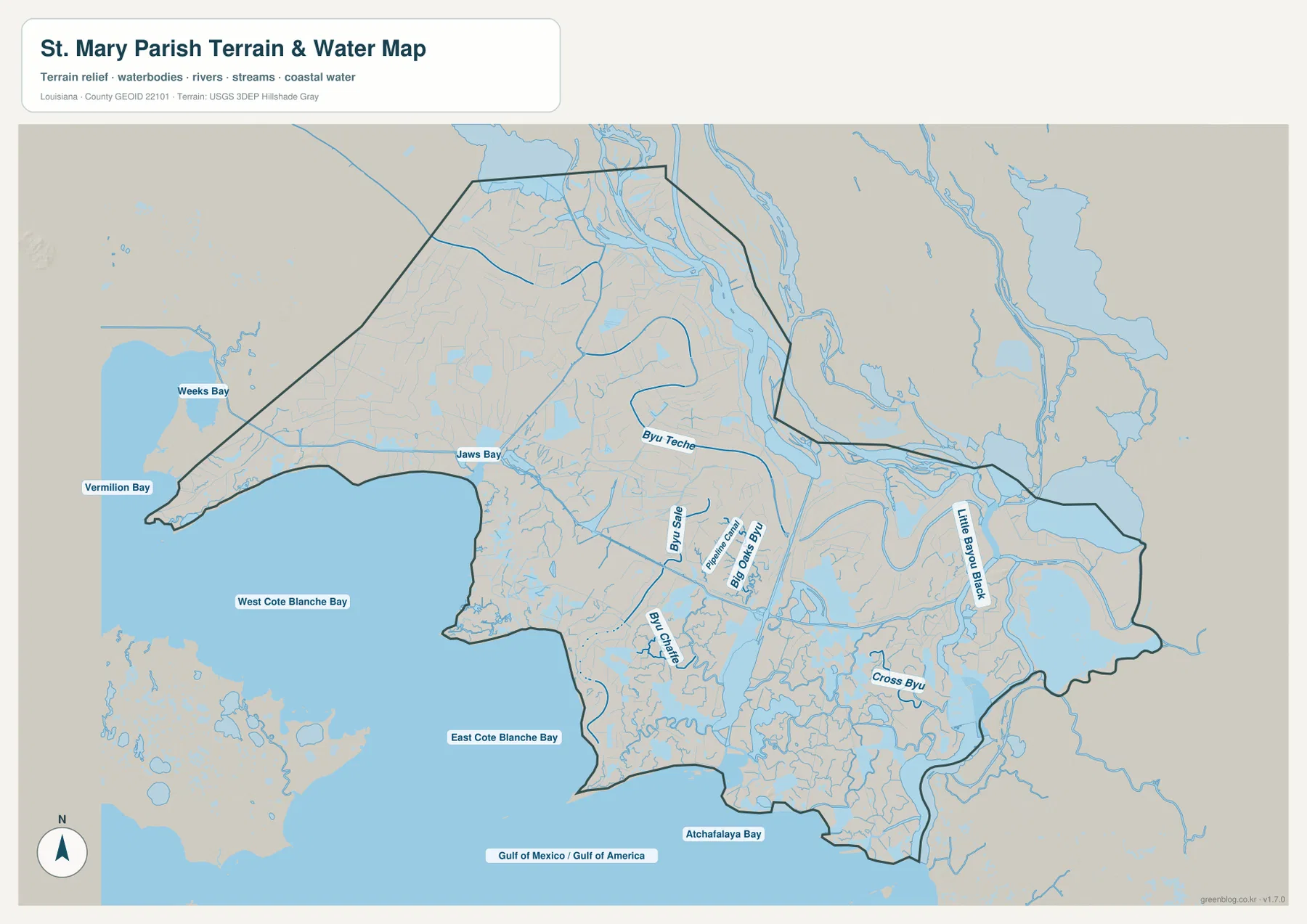
Bayou Teche and Bayou Sale connect the inhabited north with the marsh interior
The terrain-and-water map makes Bayou Teche one of the most useful inland references. It follows the populated northern belt around Franklin and the surrounding communities, while Bayou Sale lies farther south in a landscape with far fewer roads and many more channels. The two waterways help show the transition from the parish’s developed corridor into the marsh.
Big Oaks Bayou appears east of Bayou Sale, and Bayou Chene extends through the central-southern wetland network. Little Bayou Black and Cross Bayou are prominent farther east below the Morgan City side. Areas that look almost empty on the road map become densely patterned on the water map because dozens of channels, backwaters, and marsh passages occupy the southern parish.
Cote Blanche Bay and Atchafalaya Bay reveal the parish’s broad Gulf-facing coast
The southern water map is dominated by large coastal bays. West Cote Blanche Bay and East Cote Blanche Bay occupy much of the central-southern coast, while Atchafalaya Bay lies farther east. Vermilion Bay and Weeks Bay appear to the west, and Jaws Bay is labeled closer to the interior marsh. These open-water features create a completely different geographic setting from the U.S. 90 towns only a short distance north.
The Gulf of Mexico extends beyond the southern edge, where the boundary becomes a complex mixture of marsh, open water, islands, and channels instead of a simple shoreline. This terrain-and-water map is intended for general geographic reference. It does not show current flood risk, tidal depth, navigation clearance, wetland ownership, or legal parcel boundaries, so boating, engineering, or property decisions require current specialized sources.
Reading the U.S. 90 corridor first and the coastal waters second simplifies the parish
A practical first pass begins at Franklin and follows U.S. 90 west toward Baldwin and east toward Patterson and Morgan City. Berwick and LA 182 help organize the eastern urban cluster, while LA 83 and LA 317 provide useful references for the western and southern margins. The city-index map then simplifies the same pattern into five ranked places.
For water features, begin with Bayou Teche and Bayou Sale before moving south to the two Cote Blanche bays and east to Atchafalaya Bay. Little Bayou Black and Cross Bayou help with the eastern lowlands, while Big Oaks Bayou and Bayou Chene organize the central marsh. The general map is the better choice for towns and roads; the water map is much more informative when the question involves marshes, bayous, or the coast.
High-resolution JPG files preserve small bayou labels and coastal detail
The downloadable ZIP contains the original JPG files corresponding to the three previews on this page: the general parish map, the ranked city map, and the terrain-and-water map. Each original image is 3638 by 2572 pixels, providing more room to inspect route numbers, place names, bayou labels, and coastal-water names than the web preview. The larger files are especially useful around Morgan City and across the detailed Cote Blanche marshes.
Choose the general map when the Franklin–Morgan City road corridor and parish boundary need to appear together. Use the city index for a quick comparison of Morgan City, Franklin, Patterson, Berwick, and Baldwin. The water map is the better choice for Bayou Teche, Bayou Sale, Cote Blanche Bay, Atchafalaya Bay, and the dense southern channel network. These are general reference maps rather than legal boundary, survey, flood-risk, or real-time navigation products.
Frequently Asked Questions
What is the parish seat of St. Mary Parish?
Franklin is the parish seat. Louisiana’s official parish profile identifies Franklin as the seat, and St. Mary Parish Government operates from the courthouse there. On the map, Franklin also works well as a central reference between Baldwin to the west and Patterson and Morgan City to the east.
Do the numbers 1 through 5 on the city map show distance from Franklin?
No. They are rankings for Morgan City, Franklin, Patterson, Berwick, and Baldwin, not straight-line or driving distances. Actual travel mileage and time should be checked with the general road map and current navigation information.
Can the Cote Blanche Bay and Atchafalaya Bay map be used for boating or flood decisions?
No. It is a general geographic reference showing Bayou Teche, coastal bayous, Cote Blanche Bay, Atchafalaya Bay, and nearby marsh water. It does not provide tidal depth, navigation clearance, flood status, wetland ownership, or legal property boundaries. Those decisions require current specialized information.
Map File Information
The ZIP contains the original high-resolution JPG files corresponding to the general parish map, ranked city map, and terrain-and-water map shown on this page.
- Included Files: parish map JPG, ranked city map JPG, terrain-and-water map JPG
Related Maps
Sources and references
For parish-seat information, see the Louisiana.gov St. Mary Parish Profile. Local government and parish history are available from St. Mary Parish Government and its About the Parish page. Road information and maps are available from Louisiana DOTD, general boundary data from the U.S. Census Bureau TIGER/Line Shapefiles, and national water-feature data from USGS National Hydrography.
Green Map creates custom-edited map images using open geographic data sources such as geoBoundaries, Natural Earth, OpenStreetMap, and government open data. These maps are edited visual materials, not raw data files, and are provided for education, documents, presentations, and graphic reference.