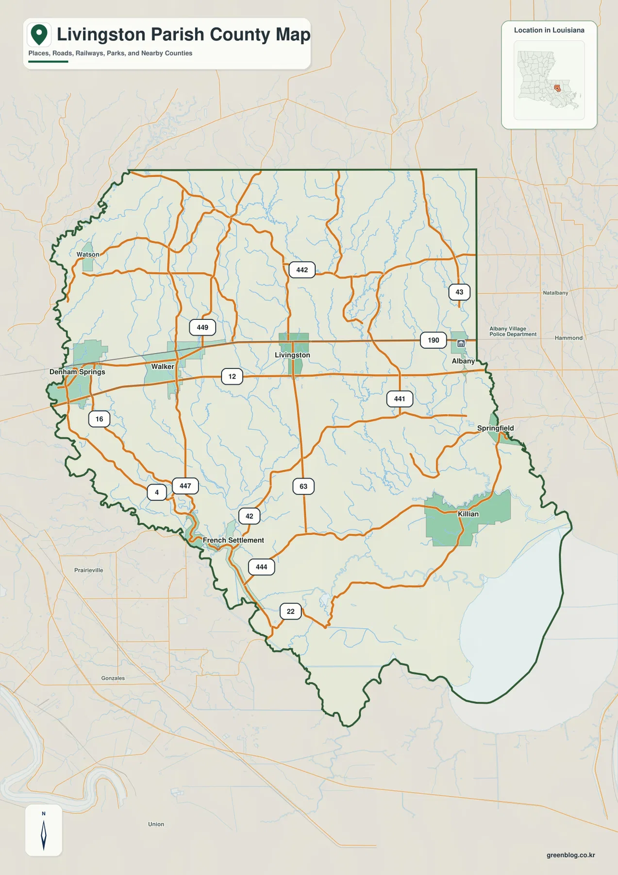
Livingston Parish in southeastern Louisiana has two very different map characters. Across the north-central section, Denham Springs, Walker, Livingston, and Albany line up around U.S. 190 and LA 12. Farther south, the pattern opens into a much more water-oriented landscape around French Settlement, Killian, Springfield, the lower river channels, and Lake Maurepas. This page explains those visible relationships using the supplied road-and-place, ranked-city, and terrain-and-water maps. The matching high-resolution JPG originals can also be downloaded together in a ZIP. High-resolution map files are available for download in the section below.
Livingston is the parish seat. Louisiana’s official parish profile identifies Denham Springs as a city, Livingston, Springfield, and Walker as towns, and Albany, French Settlement, Killian, and Port Vincent as villages; Watson is also labeled on the supplied general map as a community in the northwest. These places are not evenly distributed. The denser road-and-settlement corridor lies across the north-central portion of the parish, while the southern half contains much more open land, drainage, and lake-edge geography.
Table of Contents
U.S. 190 links Denham Springs, Walker, Livingston, and Albany
The strongest road pattern on the general map runs east-west through the upper middle of the parish. Denham Springs sits near the western edge of that corridor, followed by Walker and the parish seat of Livingston, with Albany close to the eastern boundary. U.S. 190 provides the clearest shared reference line, while LA 12 runs roughly parallel farther south. The developed footprints around Denham Springs and Walker are visibly larger than most of the surrounding communities, making the western end of the corridor easy to identify.
Several state routes branch away from this main strip. LA 442, 449, and 43 appear in the north, while LA 441, 63, 42, and 444 extend through the central and southern parts of the parish. LA 16 is prominent near Denham Springs, LA 447 continues through the southwest, and LA 22 crosses the lower section. Together these roads show a network in which a strong east-west corridor is connected to numerous north-south and diagonal local routes rather than a single highway serving the entire parish.
French Settlement, Killian, and Springfield mark the shift toward the watery south
South of Livingston and Albany, the spacing between labeled communities grows and the blue drainage network becomes much denser. French Settlement is near the southwestern side, close to the LA 16, 42, and 444 area. Killian sits farther southeast near the large lake-and-wetland section, while Springfield is positioned near the eastern boundary. These places provide useful landmarks for a part of Livingston Parish that cannot be understood as simply an extension of the U.S. 190 urban corridor.
The parish boundary also changes character in the south. The western edge bends along the Amite River area, while the southeastern outline expands around Lake Maurepas. As a result, the lower half of the map is shaped as much by water and irregular edges as by roads. Around Denham Springs or Walker, numbered routes are the fastest orientation tools; around French Settlement, Killian, and Springfield, rivers, lake margins, and the parish outline become just as useful.
The ranked city map puts Denham Springs and Walker at the top
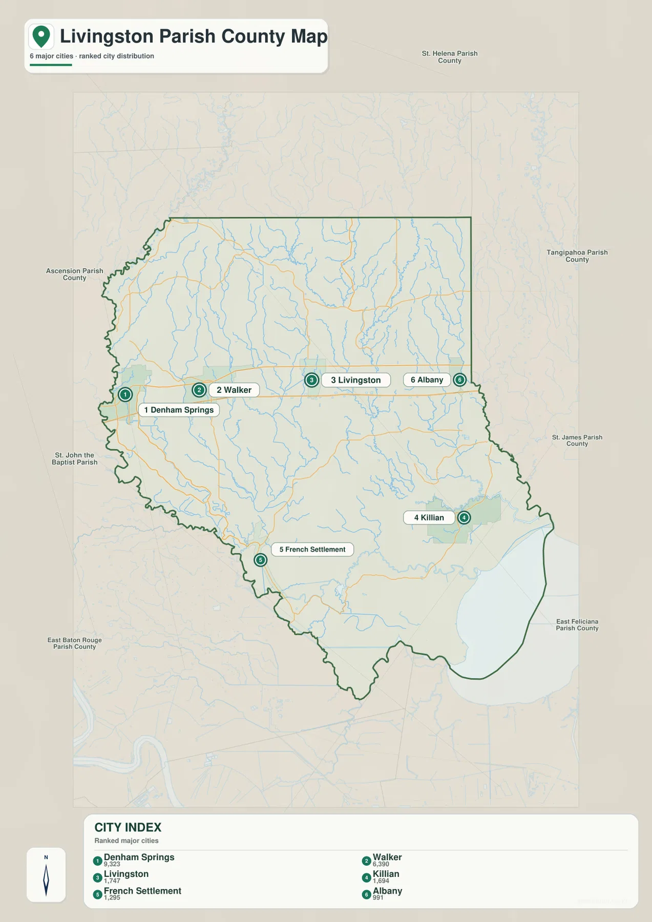
The city map is a ranked distribution graphic rather than a distance map. Denham Springs is numbered 1 and Walker 2, followed by Livingston, Killian, French Settlement, and Albany. Their positions reinforce the broader parish pattern: the top three are concentrated near the north-central road corridor, while Killian and French Settlement lie well to the south. Albany is separated toward the eastern boundary, giving the six selected places a wide geographic spread.
Springfield and Watson are visible on the general parish map but are not included in this six-place index. That is an important limitation when using the graphic. It is best treated as a simplified comparison of selected major communities rather than a complete settlement inventory. For broader place coverage, the general map is the better choice; for a quick visual comparison of the six ranked locations, the city graphic removes enough detail to make the distribution immediately clear.
The Amite River defines the west while smaller creeks fill the interior
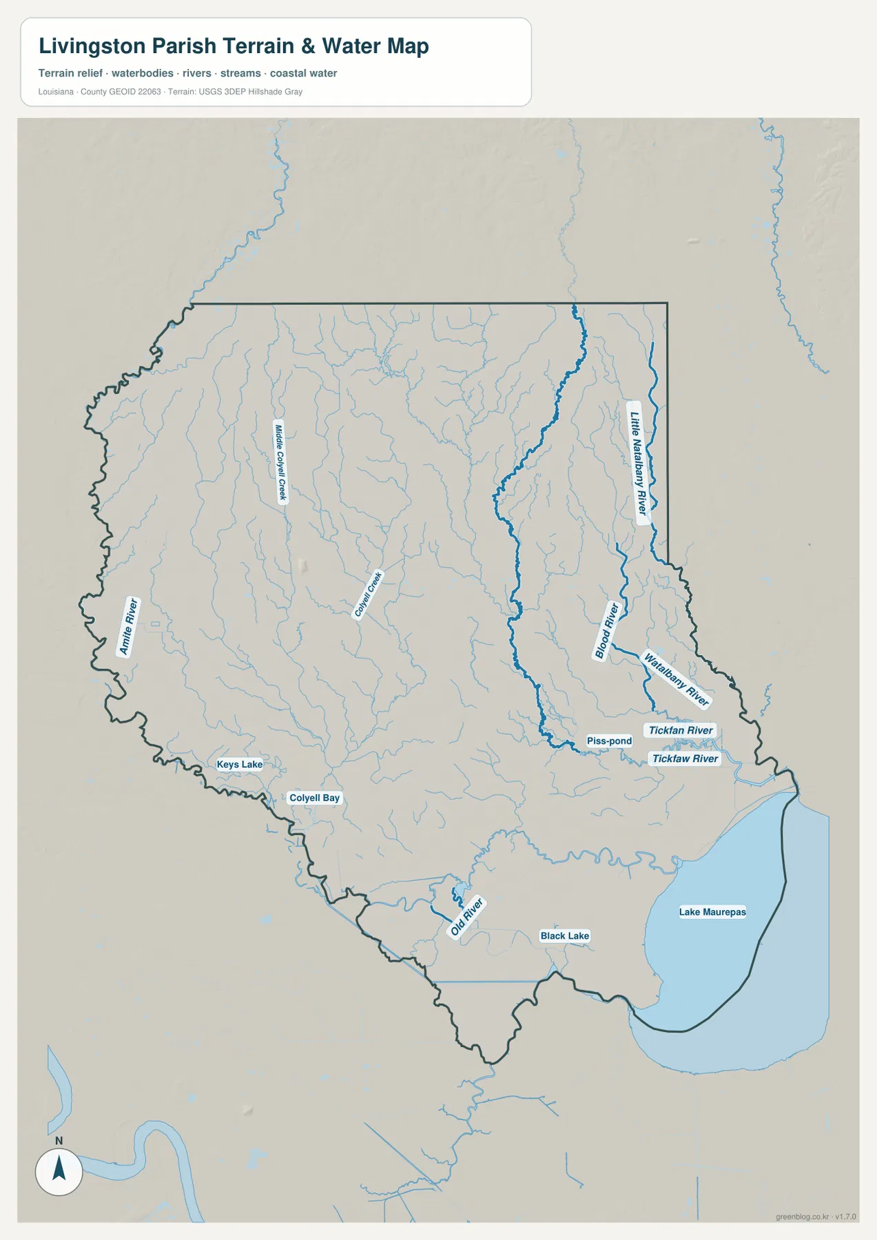
On the terrain-and-water map, the Amite River is the strongest feature along the western side of the parish. It follows a winding course near the boundary and continues toward the lower part of the map. Inside the parish, Middle Colyell Creek and Colyell Creek are among the labeled waterways crossing the central and western interior. Numerous smaller tributaries fill the spaces between them, revealing a drainage network that is easy to overlook when roads and town labels dominate the general map.
Keys Lake and Colyell Bay appear in the southwest as smaller named water bodies. They are not comparable in size to Lake Maurepas, but they help distinguish the lower western part of the parish from the northern road corridor. The water layer is intended to show location and relative connections. It does not provide streamflow, channel depth, flood-zone status, or legal water boundaries, so those questions require specialized current sources.
The Tickfaw and Natalbany rivers lead toward Lake Maurepas
The eastern half contains another major set of waterways. Little Natalbany River and Natalbany River descend through the northeast and east, while Blood River and Tickfaw River become prominent farther south. Several of these channels converge or run close together before reaching the broad lowland and lake-edge environment. Old River and Black Lake are labeled in the southern interior, adding larger water features to a landscape already crossed by many narrow tributaries.
Lake Maurepas dominates the southeastern corner of the water map. Its broad shoreline makes the lower parish look fundamentally different from the developed Denham Springs–Walker corridor. A Louisiana Coastal Protection and Restoration Authority parish fact sheet similarly describes Livingston Parish as ranging from rolling, forested terrain to cypress forests and marshes bordering Lake Maurepas and the Amite River. That context is useful, but flood and storm-surge decisions still require current hazard products rather than this general reference map.
Road landmarks work best in the north; water landmarks work best in the south
A simple way to orient yourself is to begin with the Denham Springs–Walker–Livingston–Albany sequence along U.S. 190. From there, add French Settlement in the southwest, Killian in the southeast, and Springfield near the eastern side. Watson serves as a useful northwestern reference. Once that settlement framework is established, the water map becomes easier to follow because the rivers and creeks can be tied back to familiar sections of the parish.
For waterways, use the Amite River and Lake Maurepas as the two largest anchors. Middle Colyell and Colyell creeks help organize the central-western area, while the Natalbany, Blood, and Tickfaw rivers define much of the east. The three map types answer different questions: the general map combines communities, roads, and boundaries; the ranked city graphic simplifies selected settlements; and the water map gives far more room to rivers, creeks, lakes, and the southern shoreline.
High-resolution JPG files make the smaller road and water labels easier to inspect
The downloadable ZIP contains the three original JPG files corresponding to the previews on this page: the general parish map, the ranked city map, and the terrain-and-water map. Each original image is 2572 by 3638 pixels, which gives more room to enlarge route numbers, community labels, creek names, and the intricate southern boundary than the web preview. The files are practical for printing, classroom material, presentation slides, or personal geographic reference.
Choose the general map when settlements, roads, and the parish boundary need to appear together. Use the city index for a quick comparison of Denham Springs, Walker, Livingston, Killian, French Settlement, and Albany. The terrain-and-water map is the better option for the Amite River, Tickfaw River, Lake Maurepas, and the smaller drainage network. These maps are general references rather than legal boundary, surveying, flood-hazard, or real-time navigation products.
Frequently Asked Questions
What is the parish seat of Livingston Parish?
Livingston is the parish seat. It lies in the north-central part of the parish along the same broad U.S. 190 corridor as Walker and Albany. Denham Springs has the largest visual footprint among the labeled communities, but the administrative seat is Livingston.
Does the ranked city map show every community in Livingston Parish?
No. The ranked graphic includes Denham Springs, Walker, Livingston, Killian, French Settlement, and Albany. Other places such as Springfield and Watson are labeled on the general parish map but are not part of the six-place city index, so use the general map when broader community coverage is needed.
Can the Lake Maurepas water map be used as a flood-risk map?
No. The terrain-and-water map is a general geographic reference showing Lake Maurepas, the Amite River, Tickfaw River, and other waterways. It does not provide flood-zone classifications, storm-surge depth, water depth, navigability, or legal property boundaries. Those decisions require current official hazard and jurisdiction data.
Map File Information
The ZIP contains the original high-resolution JPG files corresponding to the general parish map, ranked city map, and terrain-and-water map shown on this page.
- Included Files: parish map JPG, ranked city map JPG, terrain-and-water map JPG
Related Maps
Sources and references
For parish-seat and municipality information, see the Louisiana.gov Livingston Parish Profile and Livingston Parish Government. General boundary data are documented by the U.S. Census Bureau TIGER/Line Shapefiles, while national water-feature data are documented through USGS National Hydrography. Additional context for the southern wetland and Lake Maurepas environment is available in the Louisiana Coastal Protection and Restoration Authority Livingston Parish fact sheet.
Green Map creates custom-edited map images using open geographic data sources such as geoBoundaries, Natural Earth, OpenStreetMap, and government open data. These maps are edited visual materials, not raw data files, and are provided for education, documents, presentations, and graphic reference.