Jefferson Parish crosses several landscapes that do not look much alike on a single page. Kenner and Metairie sit along the urbanized southern edge of Lake Pontchartrain, while Gretna, Westwego, Marrero, and Harvey are arranged around the bends of the Mississippi River. South of that cluster, Jean Lafitte marks the entrance to a broad wetland zone, and Grand Isle lies at the coastal end of the parish. The downloadable ZIP on this page contains the three high-resolution JPG originals that correspond to the parish, city-distribution, and water maps shown below.
Reading Jefferson Parish only as part of the New Orleans metropolitan area misses most of its north-to-south extent. The road labels are dense near Lake Pontchartrain and the Mississippi River, then thin out as marsh channels and bays take over farther south. Louisiana’s official parish profile identifies Gretna as the parish seat, but the full parish boundary reaches far beyond the riverfront administrative center. The maps are therefore organized around three concrete questions: where the roads and communities sit, how the selected cities are distributed, and where the major water bodies appear between the lakefront and Grand Isle.
Table of Contents
The parish outline connects a dense lakefront urban area to a long southern wetland corridor
The general parish map is busiest at the northern end. Kenner is shown close to Lake Pontchartrain, with Metairie immediately to the east and the New Orleans area just beyond the parish boundary. Moving toward the Mississippi River brings Avondale, Bridge City, and Westwego into view, followed by the river communities around Gretna, Marrero, and Harvey. The concentration of roads and place names in this relatively small zone makes the northern end look much larger than it is when compared with the parish as a whole.
Several numbered routes cross this urban section, including U.S. 90 and state routes around the river bends. South of Marrero and Harvey, LA 45 provides a recognizable route toward Jean Lafitte. The visual change is abrupt: road labels become less crowded, settlement names are farther apart, and the parish boundary continues through a landscape where waterways occupy much more of the page. This transition is one reason a full-parish map is more informative than a cropped metropolitan map for anyone trying to locate Grand Isle within Jefferson Parish.
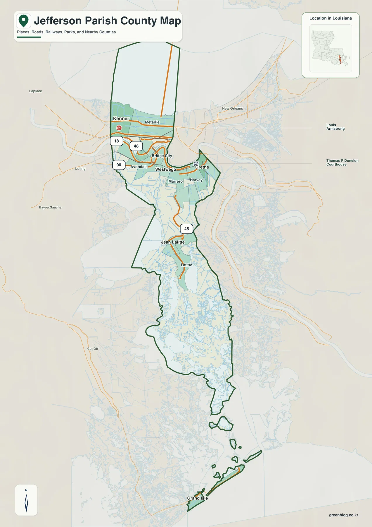
The same map also shows why nearby-looking communities are not always simple east-west neighbors. The Mississippi River curves through the northern part of the parish, so the waterway itself is essential when comparing Gretna, Westwego, Marrero, Harvey, and Bridge City. Their positions make more sense when the bends of the river are treated as the reference rather than a straight compass line. The map is intended for geographic orientation; current road closures, traffic conditions, and turn-by-turn travel should be checked with up-to-date transportation sources.
Gretna and the West Bank communities sit around the Mississippi River rather than on a simple grid
Gretna, the parish seat, appears near the Mississippi River in the northern urban portion of Jefferson Parish. Westwego lies farther west along the river, while Marrero and Harvey occupy the larger developed area to the south and southeast. Bridge City is positioned closer to the river on the northwestern side of this cluster. Because the river curves strongly, two places that look close in straight-line terms may be separated by the waterway and a limited set of crossings.
That river-centered arrangement also separates the parish’s administrative geography from its physical length. A visitor familiar with Gretna or Kenner could easily think of Jefferson Parish as a compact suburban jurisdiction, yet the boundary continues far south beyond the continuous street network. Jean Lafitte and Lafitte appear after a long decrease in road density, and Grand Isle is isolated near the bottom of the map. The full outline therefore links an urban riverfront to a coastal parish segment that is geographically and visually distinct.
The city index separates six named places without implying mileage between them
The city-distribution map strips away most of the road detail and marks six places with numbered symbols. The CITY INDEX lists Kenner as 1, Gretna as 2, Harahan as 3, Westwego as 4, Jean Lafitte as 5, and Grand Isle as 6. Those numbers are index positions used to match labels with locations on the page. They are not mile markers, route order, or a ranking of travel distance.
The northern four markers sit within the compact metropolitan end of the parish, although they are not all on the same side of the Mississippi River. Jean Lafitte is noticeably farther south, beyond the continuous urban cluster. Grand Isle is separated again at the coastal end of the parish, making the north-south spread especially obvious in this simplified version. The lack of secondary roads makes the map convenient when a presentation or classroom handout needs the main place names without the dense street network of the general map.
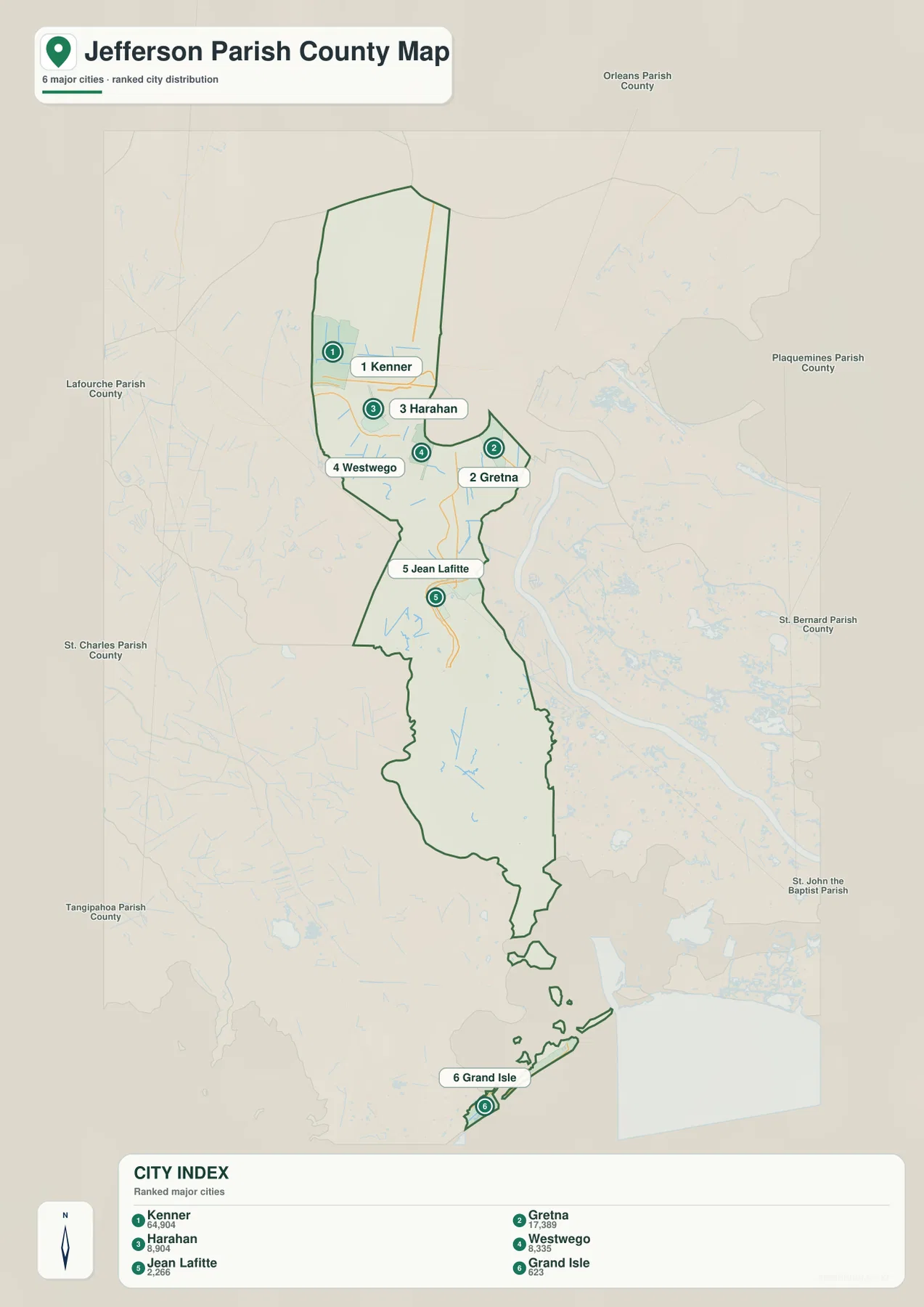
No connector lines or mileage figures are drawn between the six places, so the map should not be used to estimate driving time or straight-line distance. Its purpose is positional comparison within the parish outline. For travel planning, the numbered index should be paired with current routing information rather than treated as a distance scale.
Bayou Perot, Catahoula Bay, and neighboring waters dominate the southern half of the water map
The water map changes the emphasis from roads to named rivers, lakes, bayous, and bays. Lake Pontchartrain forms the large northern reference, while the Mississippi River cuts through the developed part of the parish. Farther south, Bayou Perot becomes a prominent feature, and Catahoula Bay, Turtle Bay, Bay Batiste, and smaller channels occupy much of the wetland interior. The repeated alternation of water and narrow land areas explains why the southern parish boundary looks irregular compared with the urban north.
Around Grand Isle, the map reaches the open coastal setting at the bottom of Jefferson Parish. Grand Isle is easier to understand here as part of a network of bays, marsh water, and coastal channels rather than simply as the last town on a north-south list. Jean Lafitte provides a useful midpoint between the developed river corridor and this southern water-dominated landscape. That relationship is visible without assuming anything about flood depth, navigability, property lines, or present water conditions.
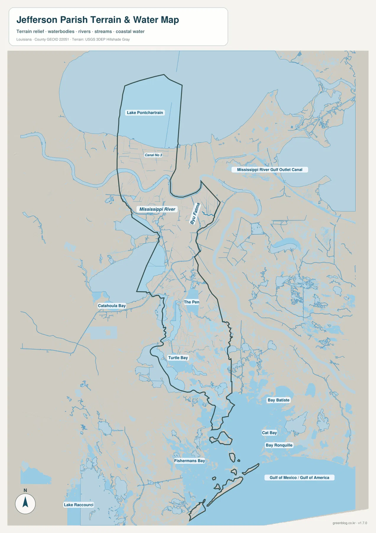
This water reference is not a navigation chart, flood-hazard product, parcel map, or legal boundary survey. It is best used to identify the relative positions of named water bodies and to compare them with the roads and settlements shown on the general map. When the two maps are viewed together, the north is defined largely by communities and transportation routes, while the southern portion is defined by the arrangement of bays, bayous, and marsh water.
Choosing the right file depends on whether the task is roads, place names, or water features
For a broad orientation to Jefferson Parish, the general map contains the most combined information because it keeps the boundary, roads, settlements, and major water features on one page. The city-distribution map is less crowded when only Kenner, Gretna, Harahan, Westwego, Jean Lafitte, and Grand Isle need to be identified. The water map is the better choice when the subject is Lake Pontchartrain, the Mississippi River, Bayou Perot, the southern bays, or the coastal setting around Grand Isle.
The ZIP archive contains the original JPG for each of those three maps. Every original is 2572 × 3638 pixels, which leaves more room for small labels when printing or enlarging the image than the web preview does. The files can be used for personal printing, classroom material, presentation slides, regional orientation, or general reference. Surveying, legal boundary work, navigation, flood determination, and engineering decisions require current authoritative products designed for those purposes.
Frequently Asked Questions
Where is the parish seat of Jefferson Parish?
Gretna is the parish seat. Louisiana’s official Jefferson Parish profile identifies Gretna as the administrative seat, and the general map places it beside the Mississippi River within the northern urban section. Kenner and Metairie are farther north near Lake Pontchartrain, so the parish seat is not at the geographic center of the parish’s long north-south outline.
What do the numbers 1 through 6 mean on the city map?
They match the six mapped places to the CITY INDEX: Kenner, Gretna, Harahan, Westwego, Jean Lafitte, and Grand Isle. The numbers do not represent mileage, driving order, or straight-line distance. The city map contains no distance connectors, so travel measurements should come from a current routing source.
Which file should I use to locate Grand Isle in relation to the southern wetlands?
Use the general parish map first to see Grand Isle at the southern end of Jefferson Parish, then use the water map to identify nearby bays, bayous, marsh channels, and coastal water. The water map is a geographic reference only and should not be treated as a navigation chart, flood map, legal survey, or real-time conditions source.
Map File Information
Download the three high-resolution JPG originals corresponding to the parish map, city-distribution map, and water map in one ZIP archive.
- Included Files: parish map JPG, city-distribution map JPG, water map JPG
Related Maps
Sources and references
- Louisiana.gov — Jefferson Parish Profile — official state profile identifying Gretna as the parish seat and listing local municipalities.
- Jefferson Parish Government — official parish government information and administrative resources.
- Louisiana DOTD — Jefferson Parish Official Map — an official parish reference for roads, place names, and the parish area.
- USGS National Hydrography — federal reference information for rivers, channels, and other hydrographic features.
- U.S. Census Bureau TIGER/Line — official geographic boundary and feature data used for mapping reference.
Green Map creates custom-edited map images using open geographic data sources such as geoBoundaries, Natural Earth, OpenStreetMap, and government open data. These maps are edited visual materials, not raw data files, and are provided for education, documents, presentations, and graphic reference.