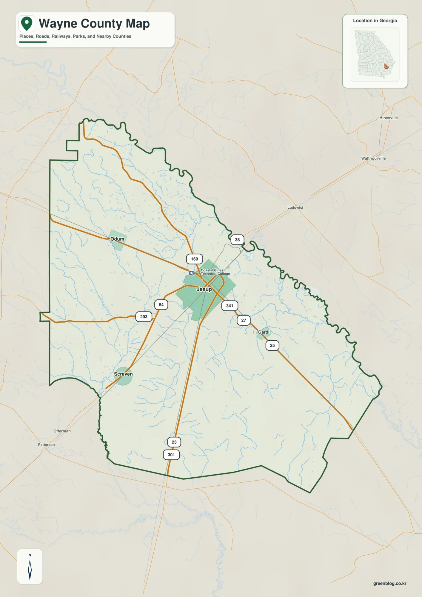
East Baton Rouge Parish combines the dense street network of Louisiana’s capital with a much broader landscape of smaller cities, river bends, bayous, and creeks. Baton Rouge occupies the southwestern part of the parish, while Zachary and Baker sit farther north, Central anchors the eastern side, and St. George lies southeast of the capital. This page includes a general parish map, a city-location map, and a terrain-and-water map. Matching high-resolution JPG files can be downloaded below as a single ZIP for print, study, presentations, or personal reference. High-resolution map files are available for download in the section below.
The parish is easier to understand when two large geographic references are kept in mind from the start: Baton Rouge and the Mississippi River. The city sits close to the western edge, where the river forms a series of broad bends, while the northern and eastern parts of the parish are crossed by the Comite River and a dense set of smaller waterways. Roads become more concentrated around Baton Rouge and the southern urban area, but the map opens up toward Zachary, Central, and the parish boundaries.
Table of Contents
A parish centered on Baton Rouge but spread far beyond downtown
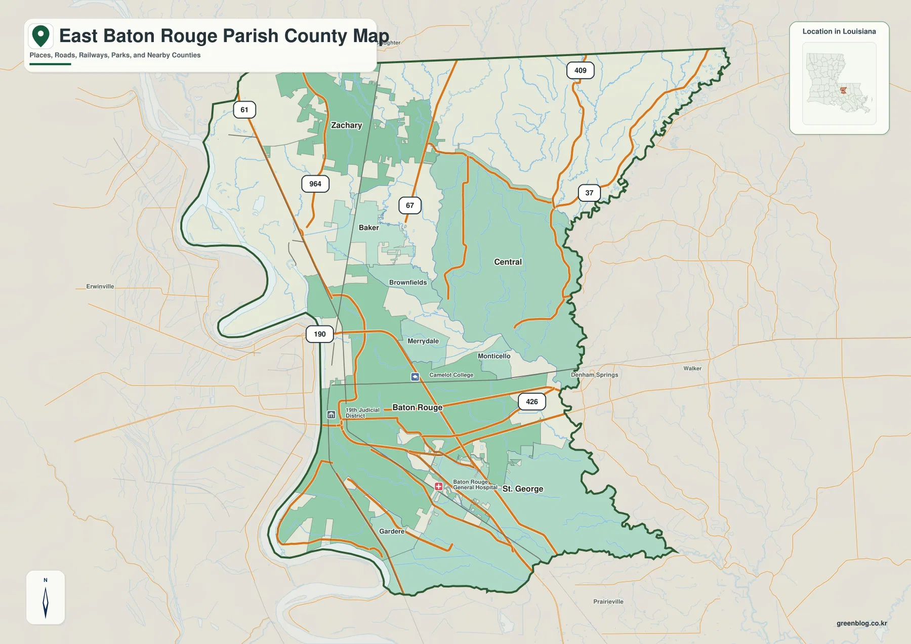
The general map makes the uneven distribution of development immediately visible. Baton Rouge is surrounded by the greatest concentration of roads and labeled places, and the network continues south toward Gardere and St. George. North of the capital, Merrydale and Brownfields lead toward Baker and Zachary. Central occupies a large area to the east, separated from the western cities by a broad interior crossed by roads and waterways rather than one continuous downtown grid.
This wider view is useful because East Baton Rouge Parish is not simply a map of Baton Rouge city. Its outline reaches north toward East Feliciana and Pointe Coupee parishes, east toward Livingston Parish, and south toward Ascension Parish. The western edge follows the Mississippi River opposite West Baton Rouge Parish. Seeing those neighboring areas together helps place the capital in its regional setting and shows why routes through the parish serve both local neighborhoods and trips to surrounding communities.
US 61 and US 190 provide the clearest road framework
For a quick orientation, US 61 is one of the easiest north-south references. It runs down the western side of the parish from the Zachary and Baker area toward Baton Rouge. US 190 forms a strong east-west reference north of central Baton Rouge and helps connect the western river side with Merrydale and communities toward the east. Together, the two highways give the reader a simple framework before the smaller urban roads are considered.
The map also labels routes 964, 67, 37, 409, and 426. Routes 964 and 67 are useful around the northwestern cities, while 37 and 409 help define the road pattern north and northeast of Central. Route 426 appears east of Baton Rouge and provides another reference near the parish’s eastern side. These lines are useful for understanding relative location, but the map is not intended to replace current navigation, construction notices, or live traffic information.
Five city anchors from Zachary to St. George
The city map strips away much of the background detail and focuses attention on five major location markers: Baton Rouge, Central, Zachary, Baker, and St. George. Baton Rouge sits in the southwestern half of the parish. Zachary is the northernmost of the five, Baker lies south of it, Central is shifted well to the east, and St. George occupies the southeastern urban area. Those points create a practical mental map for readers who are unfamiliar with the parish.
The spacing is as important as the names. Zachary and Baker form a northwestern pair, but they are distinct centers rather than one label on the same spot. Central is separated from them by the parish interior and is better understood as an eastern anchor. St. George is much closer to the Baton Rouge urban area but sits to the southeast. Louisiana’s official parish profile identifies Baton Rouge as the parish seat and lists Baker, Baton Rouge, Central City, and Zachary among its municipalities, while the current map also marks St. George as a separate city location.
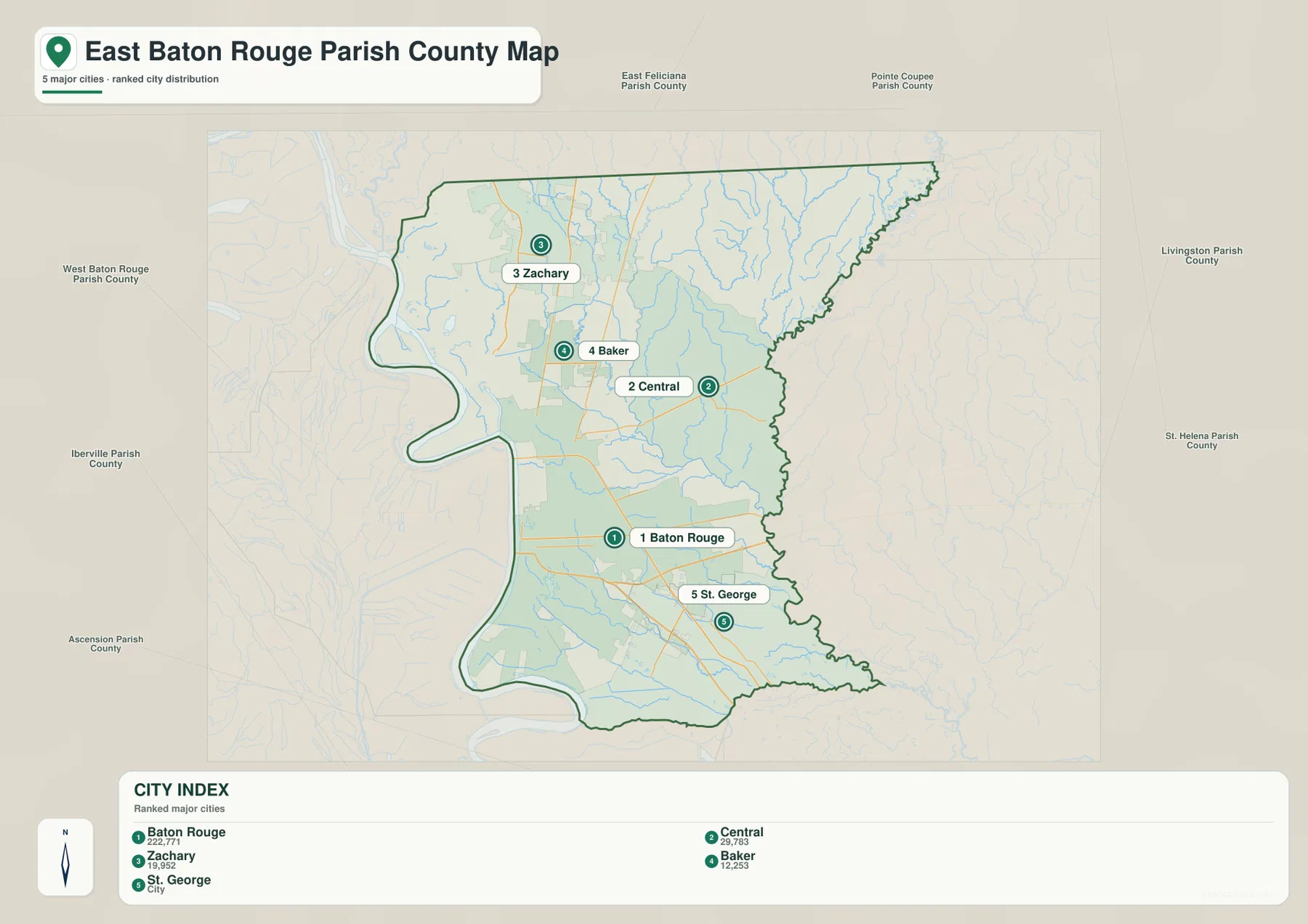
This city map is best treated as an orientation graphic, not a travel-time chart. The distance between two markers on the page does not account for traffic, bridge approaches, road design, or the actual route a driver would use. Its value is the clean view of direction and relative position, especially when the neighboring parishes are visible around the outer edge.
The Mississippi River defines the western frame
The terrain-and-water map changes the visual emphasis almost completely. The Mississippi River becomes the dominant feature along the western side, curving through several large bends beside Baton Rouge and the lower half of the parish. Because the parish boundary follows this river corridor for a substantial distance, the Mississippi is both a physical landmark and one of the simplest ways to recognize the western edge of East Baton Rouge Parish.
Several smaller water bodies appear near the river and urban area. Grand Bay, Red Lake, and Scott Lake are labeled toward the western side, while City Park Lake and University Lake sit inside Baton Rouge. The contrast is useful: the same map shows an enormous regional river and much smaller local lakes without confusing their scale. Lake Sherwood provides another recognizable point farther southeast, away from the main river corridor.
Comite River, Cypress Bayou, and the branching eastern drainage
North and east of Baton Rouge, the water pattern becomes more finely branched. The Comite River runs through the north-central part of the parish, while Sandy Creek follows a long line near the northeastern edge. White Bayou and Cypress Bayou are labeled farther into the interior. Moving south, Jones Creek and Ward Creek cross the more developed part of the parish and show how natural drainage continues through the urban landscape rather than stopping at city boundaries.
The number of smaller tributaries is just as important as the named streams. Thin blue lines spread through the northern and eastern sections and converge into larger channels, creating a very different visual pattern from the single broad Mississippi River on the west. Colyell Bay is labeled beyond the southeastern edge, helping place the lower drainage area in relation to the parish boundary. The map is useful for recognizing where streams, lakes, and bayous are located, but it is not a flood-hazard map, navigation chart, drainage-engineering plan, or legal water-boundary document.
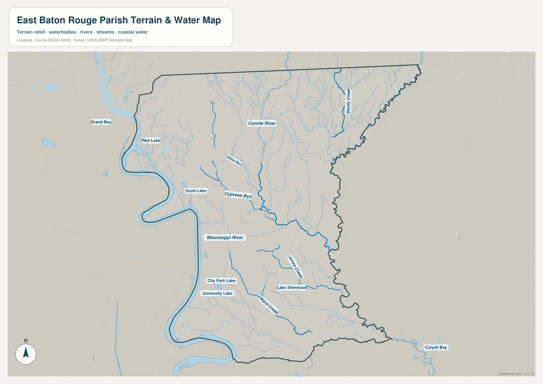
The shaded terrain underneath the waterways adds a general sense of low and higher ground, especially around stream corridors, but it should not be read as survey-grade elevation data. Its purpose is to make the drainage pattern easier to see. For precise elevation values or engineering work, the USGS 3D Elevation Program or another authoritative elevation source is more appropriate.
What changes when you switch between the three views
One map can make East Baton Rouge Parish look primarily urban, while another makes it look dominated by water. The general parish map emphasizes streets, highways, and labeled communities. The city map turns those details into a simpler set of anchors. The terrain-and-water map removes much of the road emphasis and reveals how the Mississippi River, Comite River, Cypress Bayou, Ward Creek, and many smaller channels fit around the same cities.
Central is a good example. On the city map it is an eastern city marker, but on the water map the surrounding streams become a major part of the picture. Baton Rouge is the strongest urban reference on the first two maps, yet the water map places the city in direct relation to the Mississippi River, City Park Lake, and University Lake. St. George becomes easier to place when the road network is compared with Ward Creek and Jones Creek. Moving between the maps adds context without crowding every type of information into a single image.
Choosing a map for print, study, or a presentation
The general map is the most practical first choice for a report or regional overview because it combines the parish outline, city names, and major roads. The city map is cleaner for explaining where Baton Rouge, Zachary, Baker, Central, and St. George sit relative to one another. The terrain-and-water map is the better option when the subject is the Mississippi River, local lakes, bayous, or drainage across the parish.
The downloadable ZIP contains the original JPG version of each map at 3638 by 2572 pixels. Those files are more suitable than the lighter webpage images when a map needs to be printed, cropped, placed on a slide, or used at a larger size. Because all three share the same pixel dimensions, they can be swapped within the same document layout without changing the frame or aspect ratio.
For smaller print sizes, the city map generally remains the easiest to read because it contains fewer labels. The water map benefits from a larger page or a close crop if the smaller creek names matter. If the goal is simply to show where the parish is and how the main cities connect, the general map provides the best balance between detail and readability.
Reference limits and the role of official data
These maps are designed for orientation and visual reference. They should not be used to establish property ownership, legal municipal limits, flood-zone status, engineering elevations, or current road restrictions. Census TIGER/Line data is appropriate for official geographic boundary work, Louisiana DOTD provides authoritative road and parish map resources, and USGS National Hydrography is a stronger reference for current named water features.
For ordinary reading, the simplified maps have a different advantage: they make the regional relationships visible quickly. A reader can use Baton Rouge as the starting point, move north toward Baker and Zachary, shift east to Central, then compare those places with the Mississippi River and the Comite River drainage. That broad geographic picture is often easier to remember than a list of street directions or isolated place names.
Frequently Asked Questions
Which map is best for comparing Baton Rouge, Zachary, Baker, Central, and St. George?
Use the city-location map for the cleanest comparison of the five city anchors. It shows their relative positions without the full road background. If you also need US 61, US 190, and the parish boundary, switch to the general parish map.
Where can I see both the Mississippi River and Comite River?
The terrain-and-water map shows both clearly. The Mississippi River follows the western side of the parish, while the Comite River crosses the north-central area. Cypress Bayou, Sandy Creek, Jones Creek, Ward Creek, and several lakes are also labeled on the same map.
What is included in the downloadable ZIP?
The ZIP contains three original high-resolution JPG files: the general parish map, the city-location map, and the terrain-and-water map. Each file can be used separately for printing, document layout, or presentation work.
Map File Information
The ZIP contains the original high-resolution JPG files corresponding to the general parish map, city-location map, and terrain-and-water map shown on this page.
- Included Files: parish map JPG, city map JPG, terrain and water map JPG
Related Maps
Sources and references
- Louisiana.gov – East Baton Rouge Parish Profile
- U.S. Census Bureau QuickFacts – East Baton Rouge Parish
- Louisiana DOTD – East Baton Rouge Parish Official Map
- U.S. Census Bureau TIGER/Line Shapefiles
- USGS National Hydrography
Green Map creates custom-edited map images using open geographic data sources such as geoBoundaries, Natural Earth, OpenStreetMap, and government open data. These maps are edited visual materials, not raw data files, and are provided for education, documents, presentations, and graphic reference.