Neosho County lies in southeastern Kansas, where Chanute and Erie provide the strongest town references on the supplied maps. Chanute is the largest city marker in the northwest, while Erie sits farther east near the middle of the county. St. Paul, Thayer, Galesburg, and Earlton fill in the southern and central areas. The road network is split between the US 169 corridor in the west and US 59 in the east, while the Neosho River and several major creeks create broad low valleys across the county. High-resolution map files are available for download in the section below.
The guide follows the landscape from Chanute toward Erie and St. Paul, using the creeks and Neosho River valley to connect roads with terrain instead of presenting a four-item inventory. WebP previews are available in the article, and the matching high-resolution JPG files can be downloaded together in one ZIP for printing, classroom use, or offline reference.
Table of Contents
Chanute and Erie anchor two different highway corridors
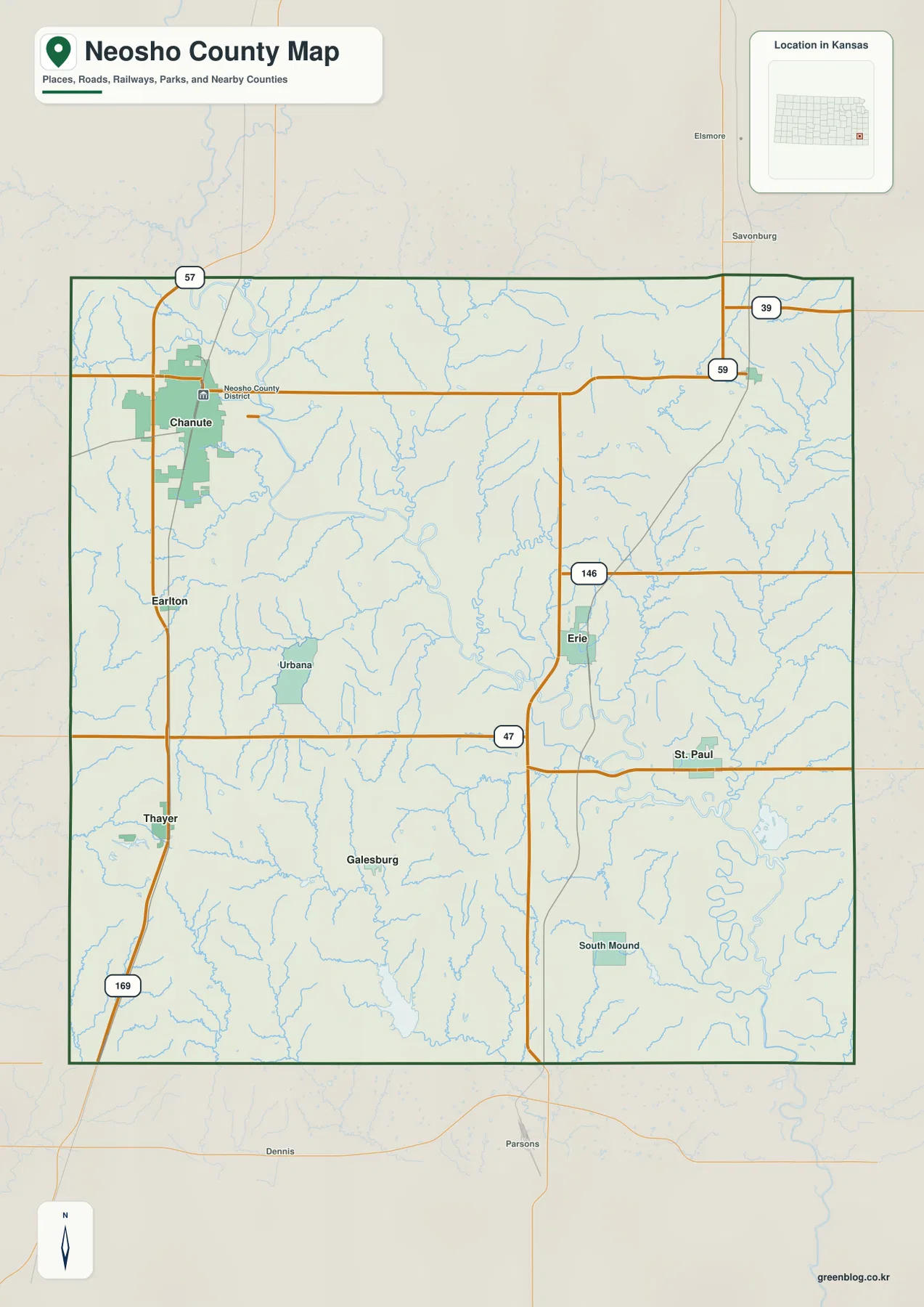
Chanute is the clearest road reference in western Neosho County. US 169 runs north–south through the city and continues toward Thayer, while K-57 approaches from the north. The city also contains rail lines, park areas, and the largest built-up footprint on the general map, making it the easiest place to orient the western half of the county.
Erie occupies the east-central interior near US 59 and K-146. Farther south, K-47 crosses toward St. Paul, while K-39 appears near the northeastern boundary. Because the western and eastern halves rely on different north–south routes, Chanute and Erie work better as paired reference points than as parts of a single continuous corridor.
Allen County is shown to the north, Crawford and Bourbon counties to the east, Montgomery County to the southeast, and Wilson and Woodson counties to the west and southwest. Parsons appears south of the county boundary. Those labels help place Neosho County within the wider southeastern Kansas road network.
Chanute dominates the six-city index, with Erie a distant second
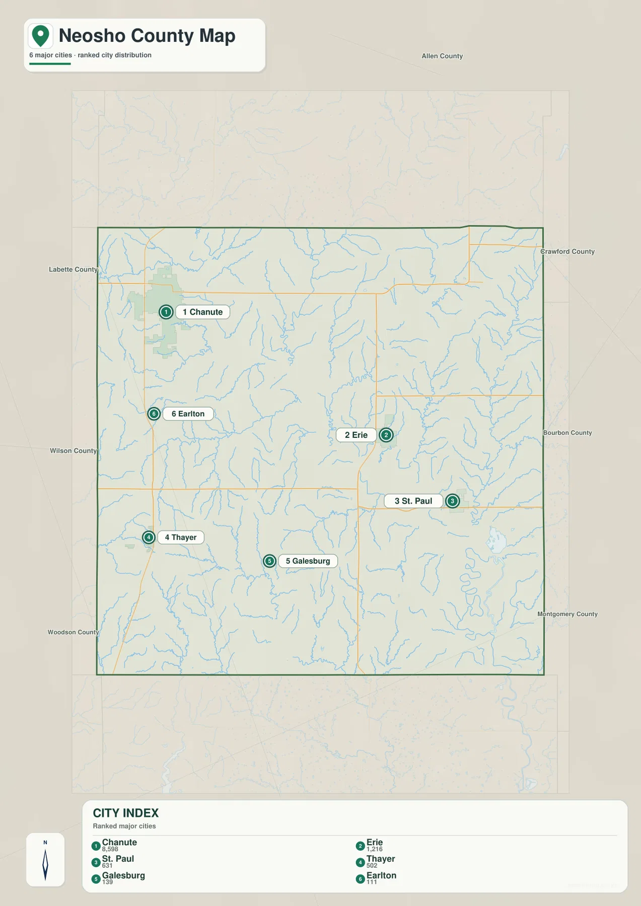
The city-distribution map lists Chanute at 8,598, Erie at 1,216, St. Paul at 631, Thayer at 502, Galesburg at 139, and Earlton at 111. These are index values printed on the supplied map rather than current official population estimates, but they make the settlement hierarchy immediately clear.
The six towns are widely spaced. Chanute is in the northwest, Erie is east of center, St. Paul is in the southeast, and Thayer is in the southwest. Galesburg lies in the south-central interior and Earlton is just south of Chanute. This arrangement makes the city map useful for dividing the county into several local areas before switching to the more detailed road layer.
Neosho County’s official website lists its courthouse in Erie and provides community links for several of these towns. That administrative role differs from the city-size pattern on the supplied map, where Chanute has by far the largest marker.
Big Creek and Canville Creek feed the central lowlands
Big Creek is one of the strongest waterways in the north-central part of the terrain-and-water map. It flows south through a long valley and is joined by smaller tributaries. Canville Creek occupies the central-eastern interior, while Elk Creek approaches from the west. Together these channels create a complex set of low corridors before water reaches the larger river system.
The Neosho River becomes the dominant feature in the southeast. It follows a broad, winding course toward the southern boundary, with Flat Rock Creek and Ogeese Creek joining the surrounding drainage network. On the elevation map, this same area forms one of the widest continuous lowlands in the county.
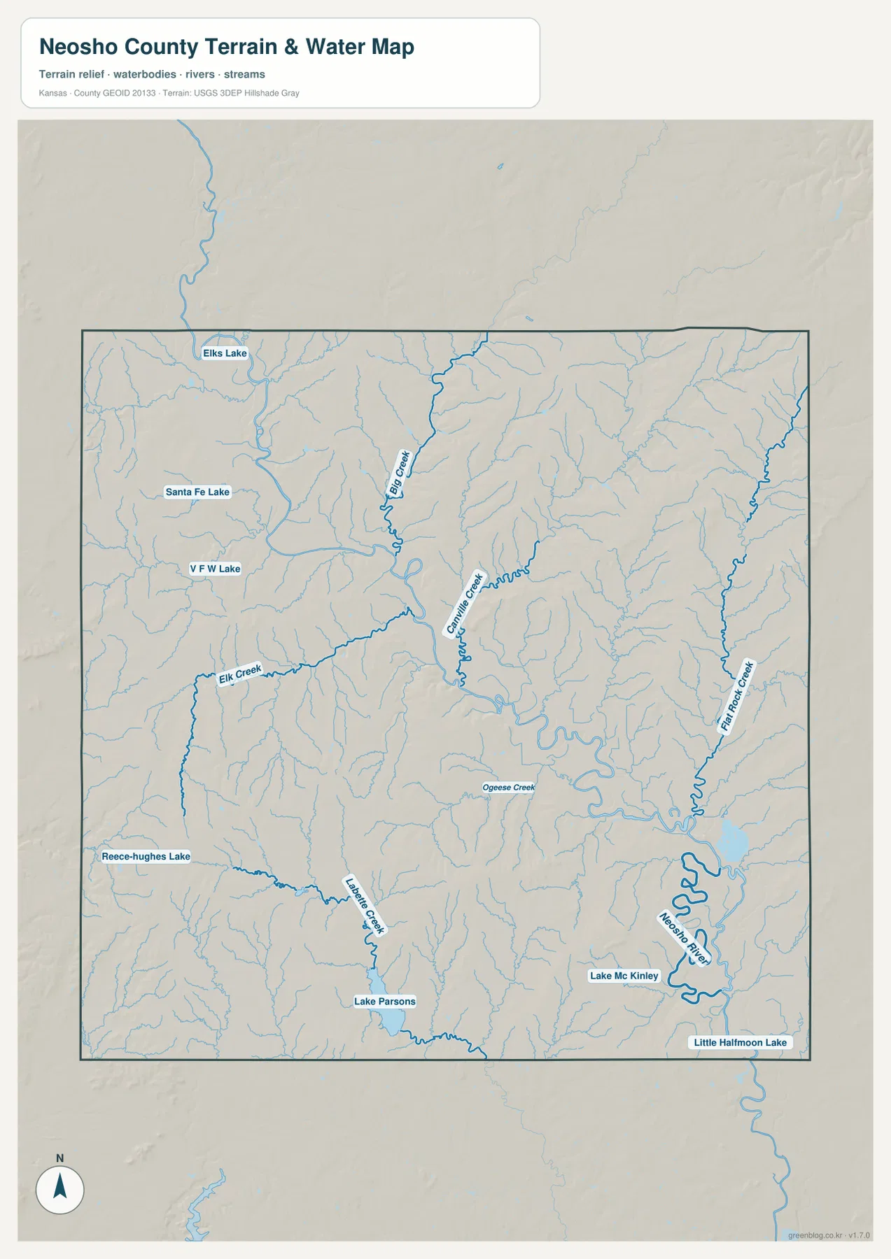
Several lakes are labeled across the county. Santa Fe Lake and V F W Lake are near the Chanute area, with Elks Lake farther north. Reece-Hughes Lake appears in the southwest, Lake Parsons near the southern edge, and Lake Mc Kinley and Little Halfmoon Lake are in the southeast. The City of Chanute describes Santa Fe Park as a large public park with boating and fishing among its amenities.
This layer is intended for geographic water reference, not flood-zone, navigation, water-quality, parcel, or legal-access decisions. Stream depth and flow can change, and a lake label does not establish current boating or recreation rules. Use current agency information when safety or facility status matters.
Elevation from about 250 to 336 meters separates river flats from higher ridges
The elevation map spans roughly 250 to 336 meters, with a mean near 289 meters. The lowest green terrain follows the Neosho River and several central creek valleys. Higher tan and brown ridges are especially prominent in the northeast and southwest, producing a stronger contrast than the road map alone suggests.
Big Creek and Canville Creek form long lower corridors through the middle of the county, while the Neosho River widens into an even broader lowland toward the southeast. Western Neosho County has a mix of rolling ground and drainage cuts around the Chanute area, and the southwestern hills rise sharply above nearby creek valleys.
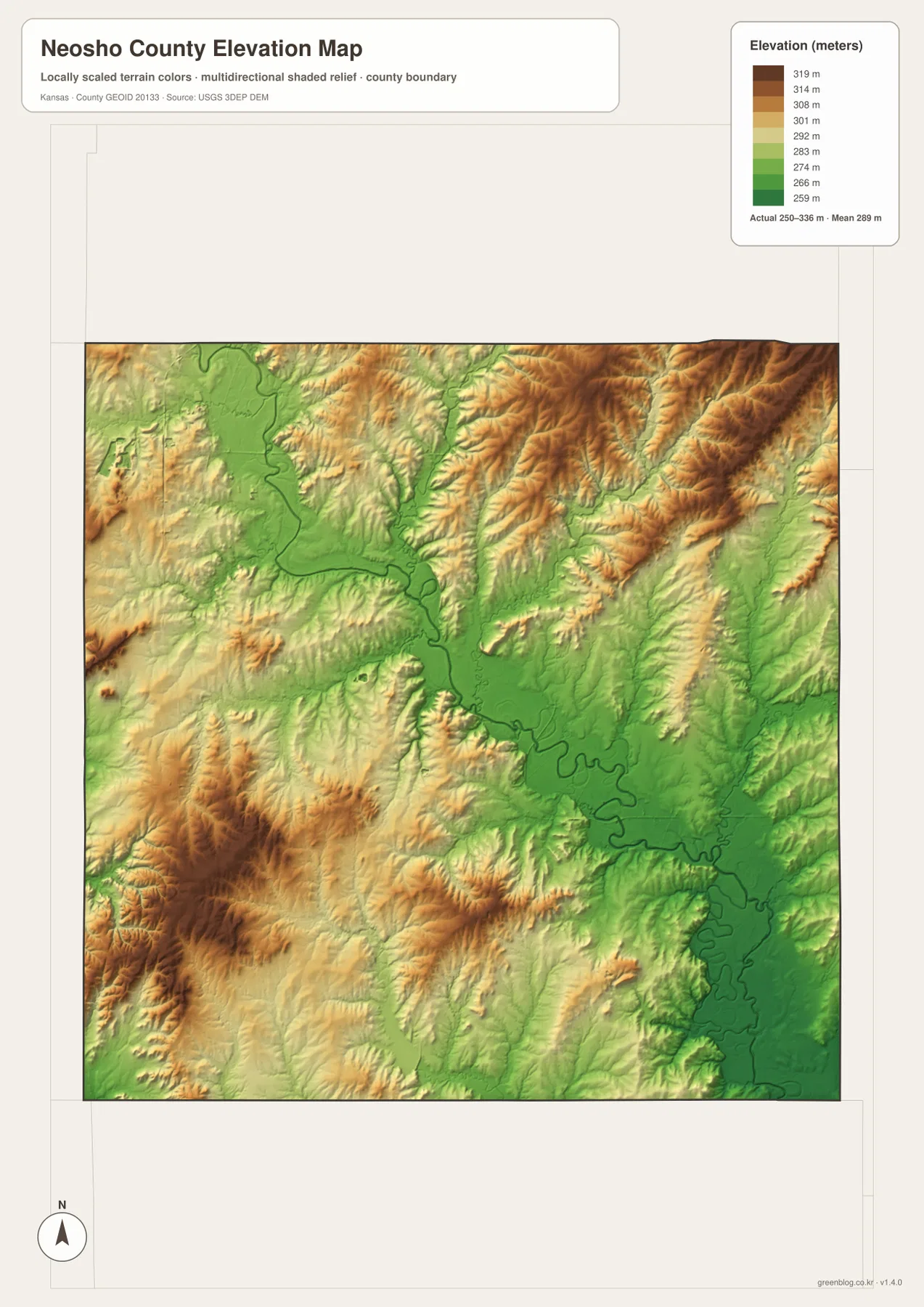
The water and elevation layers match closely. Flat Rock Creek descends through the eastern hills into lower ground, while Big Creek and Canville Creek follow green corridors through the center. In the southeast, the Neosho River occupies the county’s broadest low area, with repeated bends and tributary valleys visible around it.
This elevation surface is generalized for county-scale comparison. It should not be used to establish parcel elevations, construction grades, drainage design, or legal boundaries. Detailed site work requires more precise official elevation data and, where appropriate, professional field surveying.
Santa Fe Lake adds a clear water landmark near Chanute
Chanute is not only the largest city marker but also a useful reference for the western water features. Santa Fe Lake and V F W Lake appear near the city, while Elk Creek crosses farther south. The City of Chanute describes Santa Fe Park as a 249.3-acre public park and lists boating and fishing among its amenities.
The road map shows Chanute as a US 169 center, but the physical layers reveal a landscape broken by small creeks and low valleys. Moving from the city map to the water and elevation views gives a clearer picture of how local lakes, creek corridors, and the surrounding rolling terrain fit together.
Erie sits between the central creek network and the Neosho River lowlands
Erie is home to the Neosho County courthouse and provides the most convenient central-eastern reference on the map. US 59 and K-146 meet nearby, and St. Paul lies farther southeast along the K-47 corridor. Several smaller creeks cross the land between Erie and the Neosho River.
The elevation map shows the transition clearly. Around Erie, moderate uplands alternate with narrow creek valleys. Farther southeast, the terrain drops into the broad Neosho River lowland, where green colors occupy a much larger area. St. Paul therefore sits closer to the county’s major river corridor than Chanute or Thayer.
Following one corridor across the images explains more than a map-type checklist
For the Chanute-to-Erie corridor, begin with US 169 and US 59 and note where the two cities sit. Looking at the same area on the water image adds Big Creek and Canville Creek, which explain many of the lower corridors between them. The elevation image then shows those drainage routes below the surrounding ridges instead of treating the landscape as a flat road grid.
The same approach works around St. Paul and the Neosho River. Locate the town, trace Flat Rock Creek and the main river bend, and compare the broad green lowland with the higher ground nearby. Keeping the focus on one real place makes the differences between the supplied files easier to understand.
For posters, classroom prints, or presentation slides, the original JPG files in the download archive are preferable to enlarging the web previews. Small highway shields, creek labels, town names, and the elevation legend remain clearer at the higher resolution.
Frequently Asked Questions
Do Chanute and Erie sit on the same major highway?
No. Chanute is most easily located on US 169, while Erie sits near US 59 and K-146. The two towns anchor separate north–south road corridors on opposite sides of the county interior.
Is the Neosho River valley visibly lower than the rest of the county?
Yes. The southeastern Neosho River corridor appears as a broad green lowland, while higher ridges are more prominent in the northeast and southwest. Big Creek and Canville Creek also occupy lower valleys, but the main river corridor is wider.
Can the 250–336 meter elevation image be used for surveying?
No. It is a generalized county-scale terrain image for comparing valleys and uplands. Parcel elevations, engineering grades, drainage design, and legal boundary work require more precise official data and, where needed, professional surveying.
Map File Information
The archive contains the Neosho County general county map, city map, terrain-and-water map, and elevation map as original high-resolution JPG files.
- Included Files: Use only the versions confirmed in the article and supplied images
- File Type: Use the confirmed download contents
- Intended Use: Printing, education, presentations, and map-based projects
Related Maps
Sources and references
- Neosho County, Kansas official website — county government, courthouse, and community information
- City of Chanute: Santa Fe Park — Santa Fe Park, boating, fishing, and park amenities
- Erie, Kansas Tourism — Erie community and visitor information
- U.S. Census Bureau TIGER/Line Shapefiles — county boundary and geographic reference data
- USGS National Hydrography — river and stream reference data
- USGS 3D Elevation Program — elevation and terrain reference data
Green Map creates custom-edited map images using open geographic data sources such as geoBoundaries, Natural Earth, OpenStreetMap, and government open data.
These maps are edited visual materials, not raw data files, and are provided for education, documents, presentations, and graphic reference.